
Overview
Western Ghats rainshadow, Tamil Nadu winter rain, and Bay of Bengal cyclones
How one wind system produces a thirty-fold rainfall gradient from Mawsynram to the Thar Desert.
Previous Year UPSC-CSE Questions By the end you will be able to draft model answers for the following UPSC questions. Each question carries a collapsible framework showing how to approach it in the exam.
- UPSC Prelims 2004 General StudiesConsider the following Assertion (A) and Reason (R):
- Assertion (A): Bangalore receives much higher average annual rainfall than Mangalore.
- Reason (R): Bangalore has the benefit of receiving rainfall both from south-west and north-east monsoons.
Select the correct answer using the codes given below:
How to approach this Prelims question
Approach: Classical Assertion-Reason format testing Western Ghats orographic geography. Evaluate Assertion (A) independently against the rainfall data (Bangalore 970 mm vs Mangalore 3,800 mm), then evaluate Reason (R) independently (Bangalore does receive both monsoons). The two are evaluated separately for truth, then the explanation relationship is assessed.
Trap to watch: The trap is to read Reason (R) and conclude Bangalore must have MORE total rainfall because it receives both monsoons. In reality the rainshadow effect dominates: Mangalore's windward orographic rainfall (~3,800 mm) far exceeds Bangalore's dual-season total (~970 mm). Aspirants must check the actual rainfall numbers, not the seasonal count.
Key facts to recall:
- Mangalore (windward Western Ghats): 3,800 mm/year; SW monsoon dominant.
- Bangalore (Deccan rainshadow): 970 mm/year; both SW and NE contributions.
- Western Ghats orographic effect: windward 2,500-6,000 mm; leeward Deccan rainshadow 500-750 mm.
- Mechanism of rainshadow: dry-adiabatic warming on the leeward descent (~9.8 C/km) reduces relative humidity, suppresses precipitation.
- Bangalore NE share: approximately 25-30 per cent of annual rainfall; SW share 50-55 per cent.
Answer signal: (d) A is false but R is true
- UPSC Prelims 2017 General StudiesConsider the following statements:
- In India, the Himalayas are spread over five States only.
- Western Ghats are spread over five States only.
- Pulicat Lake is spread over two States only.
Which of the statements given above is/are correct?
How to approach this Prelims question
Approach: Pure factual recall on the spatial extent of three Indian geographical features. Each statement must be evaluated independently against the state-level mapping.
Trap to watch: Aspirants may casually accept Statement 1 (5 Himalayan states sounds plausible if you think of the visible mountain states like Jammu and Kashmir, HP, Uttarakhand, Sikkim, Arunachal Pradesh). The trap is forgetting the eastern Himalayan extension into Nagaland, Manipur, Mizoram, Meghalaya, and West Bengal (Darjeeling). Similarly, Western Ghats span 6 states, not 5; the inclusion of Gujarat (just the south-western tip) is the variable that turns 5 into 6.
Key facts to recall:
- Himalayan extent: 13 states/UTs (Jammu and Kashmir, Ladakh, HP, Uttarakhand, Sikkim, Arunachal, Nagaland, Manipur, Mizoram, Tripura, Meghalaya, Assam, West Bengal).
- Western Ghats extent: 6 states (Gujarat, Maharashtra, Goa, Karnataka, Kerala, Tamil Nadu).
- Pulicat Lake: 2 states (Andhra Pradesh and Tamil Nadu); India's second-largest brackish-water lagoon.
- Western Ghats UNESCO site: 39 component properties across Maharashtra, Karnataka, Kerala, Tamil Nadu (Goa pending); biodiversity hotspot.
- Pulicat Bird Sanctuary: critical flamingo wintering ground; declared in 1980.
Answer signal: (b) 3 only
- UPSC Mains 2014 GS-ITropical cyclones are largely confined to the South China Sea, Bay of Bengal and Gulf of Mexico. Why?
How to structure the answer in the exam
Introduction: Open by listing the five conditions for tropical cyclogenesis (warm SST, low wind shear, adequate Coriolis, moisture supply, pre-existing disturbance) and noting that these conditions co-occur with particularly favourable timing in three basins: South China Sea, Bay of Bengal, and Gulf of Mexico.
Body (sub-themes to develop):
- Warm SST: All three basins maintain SSTs above the 26.5 C cyclogenesis threshold across multi-month seasons. Bay of Bengal SSTs reach 28-30 C in pre-monsoon (April-May) and post-monsoon (October-December).
- Low wind shear: Tropical latitudes (5-25 deg) have weak upper-tropospheric westerlies, allowing the vertical structure of a developing cyclone to remain coherent. Mid-latitudes have strong westerly shear that disrupts cyclogenesis.
- Coriolis adequacy: Cyclogenesis requires latitudes >5 deg from the equator for sufficient planetary rotation. The three basins lie in the 5-25 deg latitude band.
- Moisture supply: South China Sea sits at the eastern end of the East Asian monsoon trough; Bay of Bengal sits at the eastern end of the Indian SW monsoon trough; Gulf of Mexico receives moisture from the Caribbean and the Intertropical Convergence Zone.
- Pre-existing disturbance: All three basins receive seed easterly waves or monsoon-trough lows that provide the initial convergence pattern for cyclogenesis.
- Bay of Bengal distinct features: (i) freshwater-stratified shallow warm layer (Ganga, Brahmaputra, Mahanadi discharge); (ii) eastward continuation of SW monsoon trough supplying disturbances; (iii) coastline funnel toward Tamil Nadu, Andhra, Odisha, West Bengal.
Conclusion: Conclude by noting that the three named basins simultaneously satisfy all five cyclogenesis conditions during favourable seasons, while basins like the South Atlantic (cold SST, inadequate Coriolis at low latitudes), the Mediterranean (cold SST in summer, high shear), and the south-eastern Pacific (cold Humboldt current) lack one or more conditions. Recent improvements in cyclone forecasting and pre-emptive evacuation (Phailin 2013, Fani 2019, Amphan 2020) have substantially reduced human-loss outcomes while the cyclones themselves remain confined to the same climatologically-favoured basins.
The Indian Monsoon displays sharp regional variation. The same planetary wind system delivers over 11,000 millimetres annually at Mawsynram and under 350 millimetres at western Rajasthan, a thirty-fold spatial gradient. Four mechanisms produce this gradient: the orographic effect on the Western Ghats and Khasi hills, the Deccan rain shadow, the east-to-west decay of Bay of Bengal depressions, and the north-east monsoon regime that brings October-November rainfall to the Coromandel coast. Andaman Sea cyclones add a destructive overlay in the post-monsoon season, targeting the Godavari, Krishna, and Kaveri deltas. The India Meteorological Department divides the country into 36 meteorological sub-divisions to track this variability.
Background and Historical Context
The regional variation of monsoon rainfall is the single most important determinant of Indian agriculture, water resources, and rural livelihoods. The 30-fold gradient between Mawsynram (over 11,000 mm) and Bikaner (under 350 mm) translates directly into the geography of paddy versus millet, of perennial rivers versus seasonal streams, and of canal irrigation versus groundwater dependence. UPSC Prelims questions on monsoon regional variation appear regularly, testing the windward-leeward asymmetry of the Western Ghats, the Tamil Nadu winter-monsoon anomaly, and the spatial spread of the Western Ghats and Himalayas. UPSC GS-I and GS-III Mains questions on tropical cyclones, agriculture, and disaster management anchor on these regional patterns.
What is the significance of mastering monsoon regional variation? The mechanism explains why
- Mangalore receives 3,800 mm annually while Bangalore, 350 kilometres east in the rainshadow, receives 970 mm.
- the Bengal delta receives 2,000 mm while western Rajasthan receives 350 mm despite both being on the Bay of Bengal branch’s track.
- Tamil Nadu receives 60 per cent of its annual rainfall from the Northeast monsoon (October-December) while the rest of India is then in the dry season.
- the Bay of Bengal generates approximately four times the cyclone frequency of the Arabian Sea.
Without this regional framework, students cannot reason through any of the agriculture, disaster-management, or climate-policy questions that dominate the modern UPSC pattern.
The India Meteorological Department now issues sub-divisional rainfall outlooks at the 36-division level with extended-range (10-30 day) forecasts under the Monsoon Mission framework. The Tamil Nadu Northeast monsoon outlook is released separately in late September, recognising the state's distinct climatological regime. The Mission Mausam expansion approved by the Union Cabinet in September 2024 commits approximately Rs 2,000 crore over two years for additional radar coverage in the south Indian peninsula, where the Western Ghats orographic effect and the NE monsoon's coastal-cyclone genesis create the most operationally demanding forecasting environment. Part 3 of this series develops the climate-change implications; Part 2 establishes the spatial-distribution mechanism on which the climate-change discussion rests.
Introduction: Why Identical Synoptic Flow Produces a 30-Fold Rainfall Gradient
The 30-fold spatial gradient: Mawsynram to Bikaner
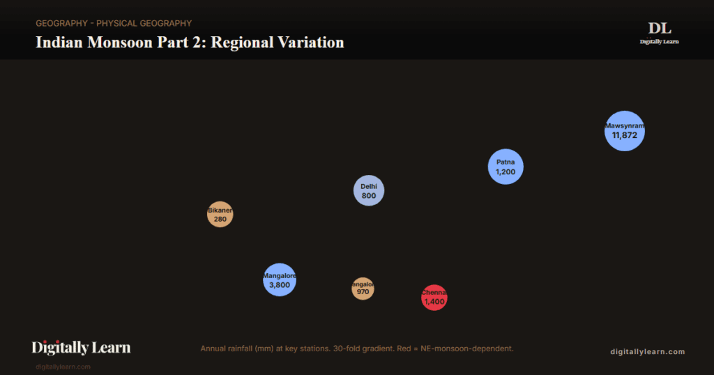
The Indian summer monsoon delivers wildly unequal rainfall across the subcontinent. Mawsynram in the Khasi Hills receives over 11,000 millimetres annually; nearby Cherrapunji receives 11,365 millimetres; the world's heaviest-recorded annual rainfall is in this orographic-funnel zone. At the other extreme, the western Rajasthan plain at Jaisalmer and Bikaner receives under 350 millimetres annually. The 30-fold gradient occurs across approximately 2,000 kilometres of horizontal distance, within the territory of a single planetary-scale wind system.
The mechanism rests on four geographic factors. The orographic effect of the Western Ghats and Khasi Hills concentrates rainfall on windward slopes and produces extensive rainshadows on leeward slopes. Differential routing of the Arabian Sea and Bay of Bengal branches creates distinct rainfall trajectories across the subcontinent.
The Bay of Bengal branch loses moisture along its westward track from the Khasi Hills to the western Indo-Gangetic plain. The Northeast monsoon regime delivers a substantial fraction of annual rainfall to a narrow zone (Tamil Nadu, south-coastal Andhra, Karaikal-Puducherry) that lies in rainshadow during the SW monsoon.
- Mawsynram: 11,872 mm/year (record); orographic funnel of Khasi Hills and Garo Hills.
- Cherrapunji: 11,365 mm/year; second-heaviest globally; 27 km from Mawsynram.
- Mangalore (windward): 3,800 mm/year; Western Ghats windward foot.
- Bangalore (leeward): 970 mm/year; Western Ghats rainshadow.
- Bengal delta: 1,800-2,200 mm/year; Bay-of-Bengal branch arrival zone.
- Delhi: 800 mm/year; Bay-of-Bengal branch terminal zone.
- Bikaner / Jaisalmer: 280-350 mm/year; rainshadow and far from moisture source.
| Rainfall tier | Annual amount | Indian regions |
|---|---|---|
| High rainfall | Over 200 cm | West coast, Western Ghats, sub-Himalayan NE, Meghalaya hills; Khasi-Jaintia hills exceed 1,000 cm |
| Medium rainfall | 100 to 200 cm | Southern Gujarat, eastern Tamil Nadu, NE Peninsula (Odisha, Jharkhand, Bihar), eastern MP, northern Ganga plain along sub-Himalayas, Cachar Valley, Manipur |
| Low rainfall | 50 to 100 cm | Western UP, Delhi, Haryana, Punjab, Jammu and Kashmir, eastern Rajasthan, Gujarat, Deccan plateau |
| Inadequate rainfall | Below 50 cm | Parts of Peninsula in AP, Karnataka, Maharashtra; Ladakh; most of western Rajasthan |
IMD 36 meteorological sub-divisions and their rainfall climatologies
The India Meteorological Department divides the country into 36 meteorological sub-divisions for operational forecasting and climatological summarisation. Each sub-division has a distinct rainfall climatology, monsoon-onset calendar, and seasonal share. The classification recognises that all-India aggregate statistics mask substantial spatial variability, and that policy applications (crop calendars, reservoir operation, drought declaration) operate at the state or district level.
The 36 sub-divisions are grouped into four broad zones for the seasonal outlook: North-West India (Punjab, Haryana, Delhi, West UP, Rajasthan), Central India (East UP, MP, Chhattisgarh, Maharashtra, Gujarat, Odisha), South Peninsula (Karnataka, Kerala, Tamil Nadu, AP, Telangana, Lakshadweep), and North-East India (West Bengal, Bihar, Jharkhand, Assam, Meghalaya, and the rest of the North-East). The Tamil Nadu sub-division receives a distinct climatological outlook because of its NE-monsoon dependence.
Mechanism Part 1: Western Ghats Orographic Effect, Windward Maxima, and Deccan Rainshadow
Orographic uplift over the Western Ghats windward slope
The Western Ghats form a 1,600-kilometre-long barrier running parallel to India's western coast from Gujarat to Kanyakumari. The range rises sharply from sea level to elevations of 1,500-2,500 metres within 30-50 kilometres of the coast. When the Arabian Sea branch of the SW monsoon strikes the windward (western) face, the moisture-laden air is forced to ascend, cool adiabatically, and release precipitation as orographic rainfall.
The lapse-rate calculation is straightforward. Surface air at 28 degrees Celsius and 80 per cent relative humidity, lifted from sea level to 1,500 metres, cools by approximately 10 degrees Celsius (dry-adiabatic lapse rate of 9.8 C/km plus moist-adiabatic effects after saturation).
The cooling drops the saturation vapour pressure, and the excess moisture condenses as cloud and rain. The result is the 2,500 to 6,000 mm annual rainfall band along the Western Ghats windward foot.
- Agumbe: 6,900-7,800 mm/year; called ‘Cherrapunji of the South’; on the Western Ghats windward escarpment in Karnataka.
- Mahabaleshwar: 6,200 mm/year; Maharashtra; one of the wettest hill stations.
- Munnar: 2,500-3,500 mm/year; Kerala; high-elevation tea region.
- Honnavar: 4,300 mm/year; coastal Karnataka; classic windward-foot station.
- Kerala coast (Kochi, Thiruvananthapuram): 2,500-3,000 mm/year.
Deccan rainshadow on the leeward slope
After releasing its moisture on the windward slope, the Arabian Sea branch descends the leeward (eastern) flank of the Western Ghats as dry, foehn-warmed air. The downsloping flow is adiabatically warmed at the dry-adiabatic lapse rate of approximately 9.8 degrees Celsius per kilometre, raising surface temperature and lowering relative humidity. The result is the Deccan rainshadow: a broad zone of 500 to 750 millimetres annual rainfall stretching across the Karnataka plateau, the Maharashtra Deccan, and the Telangana-Andhra Rayalaseema region.
The Bangalore-Mangalore contrast is the classical textbook example. Mangalore, on the windward foot at sea level, receives 3,800 mm annually. Bangalore, 350 kilometres east at an elevation of 920 metres on the Deccan plateau, receives only 970 mm annually. The ratio is approximately 4:1. The same contrast governs the cotton-yarn industry geography: cotton-growing Black Soil tracts sit in the Deccan rainshadow, requiring drought-tolerant cultivars or irrigation.
Mechanism Part 2: Bay of Bengal Branch and the East-to-West Rainfall Decay
Bay of Bengal branch deflection by eastern Himalayas
The Bay of Bengal branch of the SW monsoon enters the head of the bay around 5 June. The branch's natural south-westerly direction is rotated to the west by the eastern Himalayan wall (Patkai, Naga, Lushai hills, and the main Himalayan range). The deflected flow runs along the southern Himalayan front from Assam through Bihar to eastern Uttar Pradesh, then turns south-west across the Indo-Gangetic plain.
The first orographic obstacle the branch encounters is the Khasi Hills in Meghalaya. The hills face south, directly into the moisture-laden flow off the Bay of Bengal. The funnel-shaped topography (cliffs rising 1,200 to 1,800 metres in 20-30 kilometres) creates the world's most intense orographic precipitation. Mawsynram and Cherrapunji, 4 kilometres apart on the windward escarpment, each receive over 11,000 mm annually.
Rainfall decay from Khasi Hills to western Rajasthan
After releasing intense rainfall on the Khasi Hills, the Bay-of-Bengal branch continues westward along the southern Himalayan front. The flow loses moisture progressively as it travels, depositing rainfall on the Gangetic plain. The trajectory passes through Patna (~1,200 mm), Lucknow (~1,000 mm), Delhi (~800 mm), Punjab (~600 mm), and ends at western Rajasthan (~280-350 mm).
This east-to-west rainfall decay is the second great spatial gradient of the Indian monsoon, a textbook UPSC fact. The mechanism is moisture depletion along a continental-scale trajectory rather than orographic blocking. By the time the flow reaches western Rajasthan, much of the original moisture has been deposited upstream and the residual flow cannot sustain rainfall against the Thar Desert's strong surface heating.
| Station | Latitude (deg N) | Annual rainfall (mm) | Trajectory position |
|---|---|---|---|
| Mawsynram (Meghalaya) | 25.30 | 11,872 | Khasi Hills orographic funnel |
| Cherrapunji (Meghalaya) | 25.27 | 11,365 | Khasi Hills orographic funnel |
| Guwahati (Assam) | 26.14 | 1,800 | Lower Brahmaputra valley |
| Patna (Bihar) | 25.59 | 1,200 | Eastern Gangetic plain |
| Lucknow (UP) | 26.84 | 1,000 | Central Gangetic plain |
| Delhi | 28.61 | 800 | Indo-Gangetic plain terminal |
| Jaipur (Rajasthan) | 26.92 | 650 | Aravalli foreland |
| Bikaner (Rajasthan) | 28.02 | 280 | Thar Desert |
Mechanism Part 3: Northeast Monsoon Regime and Tamil Nadu Winter Rainfall
Northeast monsoon onset and the SW monsoon retreat
The Northeast monsoon (also called the winter monsoon or retreating monsoon) is the seasonal wind reversal that follows the SW monsoon. As the Asian landmass cools through September and October, the thermal contrast that drove the summer monsoon weakens and reverses. By October the ITCZ retreats southward to the equatorial Indian Ocean. Surface winds over the subcontinent revert to the north-east trades (Coriolis deflection of southward-bound air from the cool continent to the warm ocean).
The SW monsoon withdrawal begins from north-western India in early September, reaches the Indo-Gangetic plain by mid-September, and clears the southern peninsula by mid-October. The Northeast monsoon onset is typically declared by IMD when the north-easterly flow becomes established over the south-eastern peninsula, usually in mid-to-late October. The regime continues through November and December, with the seasonal maximum in late October and November.
Tamil Nadu and the Northeast monsoon: a distinct rainfall regime
Tamil Nadu is the only Indian state where the Northeast monsoon delivers more than half the annual rainfall. The state receives approximately 60 per cent of its annual rainfall (October-December) from the NE monsoon and only 30-35 per cent from the SW monsoon.
The mechanism rests on three factors:
- Rainshadow position: Tamil Nadu sits east of the Western Ghats, in the SW monsoon rainshadow.
- Bay of Bengal moisture: The NE flow picks up moisture from the warm Bay of Bengal as it crosses, delivering rainfall on the eastern coast.
- Tropical cyclones: Depressions and cyclones forming over the Bay of Bengal in October-December deliver concentrated rainfall to the Tamil Nadu coast.
The state-level rainfall climatology shows the regime's distinct character. Chennai receives approximately 1,400 mm/year, of which 800-900 mm arrives in October-December. Madurai receives 850 mm/year with the NE share approaching 50 per cent. Coimbatore, in the Western Ghats rainshadow, receives only 650 mm/year. The IMD-Chennai Regional Meteorological Centre issues a separate NE monsoon outlook in late September, distinct from the all-India SW monsoon outlook.
- Chennai: 1,400 mm/year; 60% from NE monsoon (October-December peak).
- Cuddalore: 1,300 mm/year; NE-dependent coastal station.
- Madurai: 850 mm/year; interior; NE share 50%.
- Tuticorin: 650 mm/year; rainshadow effect dominant.
- Karaikal-Puducherry: 1,400-1,600 mm/year; NE-dependent; cyclone-prone.
Mechanism Part 4: Bay of Bengal Tropical Cyclones in the Northeast Monsoon Regime
Bay of Bengal vs Arabian Sea cyclone frequency
Tropical cyclones in the post-monsoon retreating season (October and November) originate over the Andaman Sea and cross the eastern coast of the southern Peninsula. These cyclones are very destructive, accompanying high wind velocity and torrential rain. The thickly populated deltas of the Godavari, Krishna, and Kaveri are their preferred targets.
Every year cyclones bring disaster to this coast. A few cyclonic storms also strike the coast of West Bengal, Bangladesh, and Myanmar. The bulk of the Coromandel coast rainfall is derived from these depressions and cyclones during the retreating-monsoon season.
Such cyclonic storms are less frequent in the Arabian Sea than in the Bay of Bengal. The asymmetry reflects sea-surface temperatures and wind-shear conditions: the Arabian Sea is cooler and the upper-tropospheric easterly jet patterns less favourable to cyclogenesis over its waters.
Climate-change projections suggest a gradual rise in Arabian Sea cyclone frequency as SSTs warm. The trend is visible in the Tauktae (2021) and Biparjoy (2023) events that struck the Gujarat coast with intensities previously rare for the Arabian Sea.
- Bay of Bengal cyclones: Originate over Andaman Sea; cross eastern Peninsula coast; preferred targets are Godavari, Krishna, and Kaveri deltas.
- Arabian Sea cyclones: Less frequent historically; recent rise driven by warming SSTs.
- Coromandel rainfall: Bulk of annual rainfall on the Tamil Nadu coast derived from retreating-monsoon cyclonic depressions.
- October-November rainiest months: For Tamil Nadu, southern Andhra Pradesh, south-east Karnataka, and south-east Kerala.
Cyclone management: NDMA, IMD, and the Cyclone Warning Division
Cyclone management in India is co-ordinated by the National Disaster Management Authority (NDMA) with the India Meteorological Department Cyclone Warning Division as the operational forecast authority. The IMD operates Cyclone Warning Centres at Bhubaneswar (East Coast), Chennai (South-East Coast), Mumbai (West Coast), and Visakhapatnam (Central East Coast). Each centre issues colour-coded warnings (Green/Yellow/Orange/Red) at 96-hour, 72-hour, 48-hour, 24-hour, and 12-hour lead times.
The cyclone management response under NDMA SOP 2013 integrates IMD forecast outputs with the state-level emergency operations centres for evacuation, shelter, and post-impact rescue. The Cyclone-Prone Coastal States NDMA framework (2017) classifies Tamil Nadu, Andhra Pradesh, Odisha, West Bengal, Gujarat, Kerala, Karnataka, Goa, and Maharashtra as priority states for cyclone preparedness.
Cyclone Phailin (2013), Hudhud (2014), Fani (2019), and Amphan (2020) all benefited from improved forecast lead-time and pre-emptive evacuation, with Fani's Odisha evacuation of 1.2 million people in 24 hours becoming a global case study in disaster preparedness.
Monsoon Variability: Active-Break Cycles, Droughts, and Floods
Inter-annual variability and the drought-flood spectrum
Indian monsoon rainfall is one of the most variable rainfall regimes in the world. The coefficient of variation for all-India June-September rainfall is approximately 10 per cent over the long period, but rises to 25-30 per cent at the sub-divisional level in arid zones. The 1899, 1918, 1972, 1987, 2002, 2009, and 2015 monsoons were all severely deficient (over 10 per cent below LPA).
The 1917, 1933, 1956, 1959, 1961, 1988, and 1994 monsoons were severely surplus (>10 per cent above LPA).
The IMD drought classification distinguishes between meteorological drought (rainfall deficit greater than 25 per cent below LPA), agricultural drought (soil-moisture deficit affecting crops), and hydrological drought (reservoir and streamflow deficit). A meteorological drought year frequently produces a 4-6 per cent decline in agricultural GDP and a 1-2 per cent decline in overall GDP.
The 2002 monsoon (19 per cent below LPA) and the 2009 monsoon (22 per cent below LPA) are recent reference points; both triggered the National Calamity-Contingency Fund deployment.
- Meteorological drought: Rainfall deficit greater than 25 per cent below LPA at the sub-divisional level.
- Agricultural drought: Soil-moisture deficit affecting standing crops; correlates with mid-July to early-August break phase.
- Hydrological drought: Reservoir storage and streamflow below seasonal norm; lagging indicator that develops 1-2 months after meteorological drought.
- Coefficient of variation: All-India 10 per cent; sub-divisional 25-30 per cent in arid zones; predictability improves with multi-model ensemble forecasting.
Prelims MCQ practice
Each question below tests one specific concept on the topic. Click to reveal the answer and a full option-wise explanation.
Q1. Consider the following statements regarding the Western Ghats orographic effect:
- The windward (western) slope of the Western Ghats receives 2,500 to 6,000 mm of annual rainfall.
- The leeward (eastern) slope of the Western Ghats experiences foehn-warming at the dry-adiabatic lapse rate of approximately 9.8 degrees Celsius per kilometre.
- The Deccan rainshadow zone receives approximately 500 to 750 mm of annual rainfall.
Which of the statements given above is/are correct?
- 1 only
- 1 and 2 only
- 2 and 3 only
- 1, 2 and 3
Show answer and explanation
Answer: 1, 2 and 3
Explanation.
All three statements describe the canonical orographic effect. Statement 1: the windward annual rainfall band of 2,500-6,000 mm is observed at Agumbe, Mahabaleshwar, Honnavar, and across the Kerala coast. Statement 2: descending air on the leeward (eastern) slope is dry-adiabatically warmed at approximately 9.8 C/km, lowering relative humidity and suppressing precipitation. Statement 3: the Deccan rainshadow band of 500-750 mm characterises the Karnataka plateau, the Maharashtra Deccan, and the Telangana-Andhra Rayalaseema region. The correct answer is (d) 1, 2 and 3.
Q2. With reference to the Bay of Bengal branch of the Indian summer monsoon, consider the following statements:
- The branch enters the head of the Bay of Bengal around 5 June each year.
- The eastern Himalayas (Patkai, Naga, Lushai hills) deflect the south-westerly flow to the west.
- The Khasi Hills in Meghalaya generate over 11,000 mm of annual orographic rainfall through funnel-shaped topography.
Which of the statements given above is/are correct?
- 1 only
- 1 and 3 only
- 2 and 3 only
- 1, 2 and 3
Show answer and explanation
Answer: 1, 2 and 3
Explanation.
All three statements are correct. Statement 1: the IMD-tracked normal onset for the Bay of Bengal branch at the head of the bay is around 5 June. Statement 2: the eastern Himalayan wall (Patkai, Naga, Lushai, and main Himalayan range) turns the south-westerly flow back to the west, producing the southern-Himalayan-front trajectory. Statement 3: the Khasi Hills funnel produces the world's heaviest orographic precipitation; Mawsynram (11,872 mm) and Cherrapunji (11,365 mm) sit 4 km apart on the windward escarpment. The correct answer is (d) 1, 2 and 3.
Q3. Consider the following statements regarding the Indian Northeast monsoon:
- The Northeast monsoon delivers approximately 60 per cent of Tamil Nadu's annual rainfall.
- Chennai receives most of its NE monsoon rainfall in July-August.
- Tropical cyclones forming over the Bay of Bengal in October-December are the principal source of Tamil Nadu coastal rainfall.
Which of the statements given above is/are correct?
- 1 only
- 1 and 2 only
- 1 and 3 only
- 1, 2 and 3
Show answer and explanation
Answer: 1 and 3 only
Explanation.
Statement 1 is correct: Tamil Nadu receives approximately 60 per cent of its annual rainfall from the Northeast monsoon (October-December). Statement 2 is INCORRECT: Chennai's NE-monsoon rainfall is concentrated in October-December, not July-August; July-August is the SW monsoon season when Tamil Nadu is largely in the Western Ghats rainshadow. Statement 3 is correct: Bay-of-Bengal cyclones in October-December deliver concentrated coastal rainfall to Tamil Nadu; Phailin (2013), Vardah (2016), and Mandous (2022) are recent examples. The correct answer is (c) 1 and 3 only.
Sources and Further Reading
- NCERT Class 11 India: Physical Environment, Chapter 4 – Climate
- India Meteorological Department – Sub-divisional Rainfall
- IMD Chennai – Northeast Monsoon
- Wikipedia – Monsoon of South Asia
- Wikipedia – Northeast Monsoon
- Wikipedia – Western Ghats
- Wikipedia – Mawsynram
- Ministry of Earth Sciences – Monsoon Mission
- IITM Pune – Monsoon Mission research
- Wikipedia – Tropical cyclones in the North Indian Ocean
- IMD Cyclone Warning Division
Disclaimer
This article is an explainer for UPSC preparation and is not a substitute for primary sources. Rainfall figures, the IMD framework, and monsoon patterns are drawn from standard physical geography and IMD references. Readers should verify exact statistics against the latest official data.


