
Overview
Climate Change, Mission Mausam, and Agricultural Adaptation
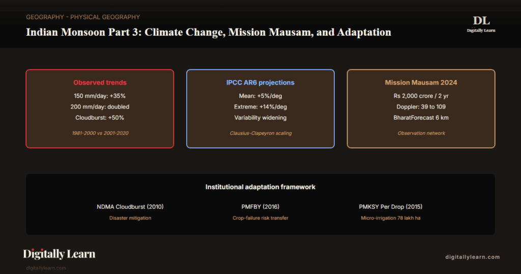
Observed monsoon trends, IPCC AR6 projections, cloudbursts, and the institutional adaptation framework.
Previous Year UPSC-CSE Questions By the end you will be able to draft model answers for the following UPSC questions. Each question carries a collapsible framework showing how to approach it in the exam.
- UPSC Mains 2024 GS-IWhat is the phenomenon of ‘cloudbursts’? Explain.
How to structure the answer in the exam
Introduction: Open with the IMD definition: a cloudburst delivers 100 millimetres or more of rain in one hour over an area of roughly 20 to 30 square kilometres.
Body (sub-themes to develop):
- Mechanism: convective instability over mountain terrain, orographic uplift, rapid ascent of warm moist air, and abrupt condensation releasing concentrated precipitation.
- Indian context: frequent over Himalayan states (Uttarakhand, Himachal Pradesh, Jammu and Kashmir, Sikkim) where the south-west monsoon flow is orographically enhanced.
- Recent events: Kedarnath 2013, Leh 2010, Amarnath 2022, and Wayanad 2024.
- Climate-change linkage: IPCC AR6 documents rising frequency of intense rainfall extremes consistent with the warming-driven rise in atmospheric moisture-holding capacity.
Conclusion: Close by linking management to the mechanism: NDMA cloudburst guidelines, IMD Doppler radar expansion under Mission Mausam, and real-time SMS alerts together reduce loss of life.
- UPSC Mains 2023 GS-IDiscuss the consequences of climate change on food security in tropical countries.
How to structure the answer in the exam
Introduction: State that climate change threatens food security in tropical countries through rising temperatures, shifting rainfall, intensifying extremes, and sea-level rise that erodes coastal cropland.
Body (sub-themes to develop):
- Temperature stress: heat waves cut paddy and wheat yields, with the Indian wheat belt losing about 5 to 7 per cent of yield per degree Celsius of rise.
- Monsoon shift: delayed onset and earlier withdrawal compress the kharif sowing window and lengthen mid-season break spells.
- Extreme events: more intense droughts, floods, and cyclones damage standing crops, while cloudbursts hit mountain agriculture.
- Sea-level rise: salinisation of coastal cropland in the Sundarbans and the Krishna-Godavari and Mahanadi deltas.
- Policy response: PMFBY crop insurance, ICAR climate-resilient cultivars, Mission Mausam forecasts, and the National Adaptation Fund.
Conclusion: Conclude that tropical countries need both domestic adaptation and global climate finance, citing India's positions at IPCC AR6 and recent COP negotiations.
- UPSC Mains 2022 GS-IIIExplain the mechanism and occurrence of cloudburst in the context of the Indian subcontinent. Discuss two recent examples.
How to structure the answer in the exam
Introduction: Define a cloudburst as a localised, intense convective rainfall event over mountain terrain, driven by orographic uplift of moist monsoon air, atmospheric instability, and latent heat from rapid condensation.
Body (sub-themes to develop):
- Mechanism: moist monsoon air forced to ascend steep terrain, rapid cooling and condensation, and concentrated precipitation release within a short window.
- Atmospheric instability: conditional instability, where lifted air becomes warmer than its surroundings and accelerates upward.
- Topographic concentration: narrow valleys channel runoff and create a downstream flash-flood multiplier.
- Indian distribution: Himalayan states such as Uttarakhand, Himachal Pradesh, Jammu and Kashmir, and Sikkim, with occasional Western Ghats events.
- Recent example one, Kedarnath 2013: a mass-casualty event combining a cloudburst with a glacial-lake outburst flood, with over 6,000 fatalities.
- Recent example two, Wayanad 2024: a Western Ghats landslide-cloudburst cascade in Kerala, showing the belt expanding beyond the Himalaya.
Conclusion: Conclude with the climate-change context (IPCC AR6 links rising intense-rainfall frequency to warming-driven moisture rise) and the management response of NDMA guidelines, Doppler radar expansion, and real-time alerts.
The Indian Monsoon under continued anthropogenic warming is undergoing three documented changes: a rising mean June-September rainfall, a faster-rising frequency of extreme single-day events, and a widening of inter-annual variability. The Clausius-Clapeyron scaling of atmospheric water vapour with temperature explains the extreme-precipitation surge; the IPCC Sixth Assessment Report assesses that heavy precipitation intensifies at roughly the Clausius-Clapeyron rate of about 7 per cent per degree of warming, while projecting an increase in South Asian summer-monsoon mean rainfall with high confidence in direction. Part 3 of the Indian Monsoon series examines the climate-change frontier of the monsoon: observed trends since 1950, IPCC AR6 projections, cloudbursts as the canonical extreme event, Mission Mausam and Monsoon Mission forecasting infrastructure, agricultural adaptation through PMFBY and PMKSY, and the policy framework for managing increased monsoon variability.
Background and Historical Context
The Indian Monsoon under climate change is the defining environmental risk for India's agricultural economy, urban infrastructure, and disaster preparedness over the coming decades. Approximately 55 per cent of India's net sown area remains rainfed; 600 million Indians depend on monsoon rainfall for their livelihood. A 10 per cent shift in mean monsoon rainfall translates to a 4-6 per cent agricultural GDP shift; a doubling of extreme single-day events stresses urban drainage, reservoir spill-management, and post-flood reconstruction budgets. UPSC GS-I Mains questions on monsoon climate-change appear regularly, and UPSC GS-III Mains questions on disaster management anchor on monsoon extremes including cloudbursts, flash floods, and tropical cyclones.
What is the significance of mastering the climate-change frontier of the monsoon? The mechanism explains why
- (a) mean June-September rainfall is projected to increase under continued warming, with high confidence in the direction of change under SSP2-4.5 and SSP3-7.0 scenarios though the magnitude remains uncertain.
- (b) extreme single-day precipitation events are projected to intensify at about 7 per cent per degree, near the Clausius-Clapeyron atmospheric water-vapour scaling rate.
- (c) cloudburst frequency over the Himalayan and Western Ghats foothills has risen approximately 50 per cent between 1981-2000 and 2001-2020, and.
- (d) inter-annual rainfall variability is widening, increasing the frequency of both severe-deficit and severe-surplus years.
Without this climate-change foundation, students cannot reason through any of the agriculture-policy, disaster-management, or urban-flooding questions that dominate the contemporary UPSC pattern.
The Mission Mausam framework approved by the Union Cabinet in September 2024 per Press Information Bureau release commits approximately Rs 2,000 crore over two years for an expanded monsoon-observation network: 87 additional Doppler weather radars taking the network from 39 to about 126 by 2026, 10 additional aircraft for upper-air observation, and a fivefold expansion of automatic weather stations toward a target of 250,000 by 2026. The framework also funds the indigenous BharatForecast System, a coupled global atmosphere-ocean model targeted at 6-kilometre resolution short-range forecasts.
The Pradhan Mantri Fasal Bima Yojana (PMFBY) launched in 2016 provides crop insurance against monsoon-driven crop failure. The Pradhan Mantri Krishi Sinchayee Yojana (PMKSY) Per Drop More Crop component, launched in 2015, expands drip and sprinkler irrigation to reduce monsoon-dependence for kharif crops. The South Asian Climate Outlook Forum (SASCOF) coordinated by IMD provides seasonal consensus outlooks for South Asian member states. Together these institutional layers form the climate-change adaptation framework.
Observed Trends Since 1950: Mean Rainfall, Extremes, and Variability
Mean June-September rainfall and the long-period climatology
The IMD long-period reference series for all-India June-September rainfall extends from 1901 to the present. The 1971-2020 long-period average is 868 millimetres; the prior 1961-2010 reference was 880 mm. The shift in the LPA itself reflects the slow downward drift in the mean over recent decades, even as inter-annual variability has widened.
Across the long period, two decadal trends are documented. The 1950-2000 era shows a slight declining trend in central Indian rainfall, attributed in part to aerosol-driven attenuation of solar heating over the Indian Ocean. The 2000-2024 era shows a partial recovery toward the long-period mean, with the 2019 and 2022 monsoons both delivering surplus rainfall.
Extreme precipitation events: the steeper rising trend
Extreme single-day precipitation events are rising at a much steeper rate than mean rainfall. IMD analysis of station data shows the frequency of days with rainfall above 150 millimetres has risen approximately 35 per cent between 1981-2000 and 2001-2020. The frequency of days above 200 millimetres has roughly doubled.
| Threshold | 1981-2000 | 2001-2020 | Change |
|---|---|---|---|
| 150 mm/day rainfall events | Baseline | Plus 35 per cent | Steeply rising |
| 200 mm/day rainfall events | Baseline | Doubled | Sharpest rise |
| Himalayan cloudburst events | Approximately 20 per year | Approximately 30 per year | Plus 50 per cent |
| Mean June-Sep rainfall | Slight decline (aerosol-attributed) | Partial recovery | Reversal |
- 150 mm/day frequency: Rose approximately 35 per cent (1981-2000 vs 2001-2020 baselines).
- 200 mm/day frequency: Roughly doubled across the same comparison.
- Mean rainfall trend: Slight decline 1950-2000 (aerosol-attributed), partial recovery 2000-2024.
- Mechanism: Clausius-Clapeyron scaling of atmospheric water vapour at approximately 7 per cent per degree of warming; IPCC AR6 assesses heavy precipitation intensifying at about this rate (assessed range 4 to 8 per cent per degree), with localised convective bursts able to exceed it.
- Operational consequence: Urban drainage infrastructure designed for 1981-2000 return periods is now under-sized for the post-2000 extreme regime.
IPCC AR6 Projections: Mean, Extremes, and Variability Under Continued Warming
AR6 Working Group I Chapter 8 monsoon projections
The IPCC Sixth Assessment Report Working Group I, released in 2021, dedicates Chapter 8 to water-cycle changes. For the South Asian summer monsoon under continued warming, AR6 projects three principal changes, with high confidence in the direction of each.
- (a) Mean seasonal rainfall: Projected to increase under continued warming, with high confidence in the direction of change under SSP2-4.5 and SSP3-7.0 scenarios; the magnitude remains uncertain and is not assessed as a fixed per-degree coefficient.
- (b) Extreme precipitation: Intensifies at about 7 per cent per degree of warming, near the Clausius-Clapeyron rate of atmospheric water-vapour scaling (assessed range 4 to 8 per cent per degree); localised convective bursts can exceed this rate.
- (c) Inter-annual variability: Widens, increasing the frequency of both severe-deficit and severe-surplus years even as the long-period mean rises.
The mechanism behind these projections is well-understood. A warmer atmosphere holds more water vapour at the same relative humidity, so precipitation falls in heavier bursts. The summer land-sea thermal contrast widens as land warms faster than ocean, strengthening the pressure gradient that drives monsoon flow. The Tibetan Plateau warms disproportionately, intensifying the elevated heat source identified in Part 1.
Aerosols, land-use change, and the regional projection uncertainty
Regional uncertainty in the IPCC AR6 projections is driven by aerosol interactions and land-use change. Aerosols over the Indian Ocean and the subcontinent reduce surface solar heating, weakening the land-sea thermal gradient and partly offsetting warming-driven monsoon intensification. As aerosol emissions decline under air-quality policy, the suppressed monsoon signal recovers.
Land-use change also affects monsoon dynamics. Conversion of forest to cropland alters surface albedo, evapotranspiration, and roughness; conversion to urban surfaces creates the urban heat-island that interacts with convective rainfall to intensify city downpours. Combined aerosol and land-use contributions add roughly 30 per cent to the AR6 regional projection envelope.
Cloudbursts: Mechanism, Recent Indian Events, and the Climate-Change Connection
Cloudburst definition and the IMD operational threshold
A cloudburst is an extreme convective rainfall event of very short duration and very high intensity, confined to a small geographical area. The India Meteorological Department operational definition specifies rainfall of 100 millimetres per hour or more over an area of approximately 20-30 square kilometres.
The mechanism rests on three atmospheric conditions that must coincide for the burst-scale rainfall to occur.
- Abundant low-level moisture: Typically supplied from the Bay of Bengal or Arabian Sea moisture transport during the south-west monsoon.
- Strong convective instability: Generated by surface heating over mountainous terrain or by orographic uplift on the windward slopes of the Himalayas and Western Ghats.
- Triggering mechanism: A small disturbance in the monsoon trough or a passing mid-tropospheric trough releases the latent instability and concentrates the precipitation.
Recent Indian cloudburst events: Uttarakhand, Himachal, Jammu and Kashmir, Sikkim
The Indian Himalayan region has seen repeated catastrophic cloudbursts in the contemporary era. Kedarnath (June 2013) produced flash floods that killed approximately 6,000 people and left 100,000 stranded. The Mandakini river surged to record levels after a cloudburst over the Chorabari glacier catchment. NDMA-led rescue operations evacuated 110,000 people across multiple districts.
Chamoli (February 2021) combined a cloudburst with a glacial-lake outburst flood, killing 200 people across the Rishiganga and Dhauliganga river valleys; the event led to the destruction of the Tapovan-Vishnugad hydroelectric facility. Amarnath cloudburst (July 2022) at the Jammu and Kashmir pilgrimage cave killed 16 yatris and demonstrated the vulnerability of high-altitude pilgrimage logistics to cloudburst risk.
- Kedarnath cloudburst (June 2013): ~6,000 deaths; Mandakini river flash flood; ~100,000 stranded; NDMA evacuated 110,000.
- Leh cloudburst (August 2010): ~250 deaths; widespread Ladakh flash flooding; first major contemporary Himalayan cloudburst.
- Chamoli (February 2021): ~200 deaths; combined cloudburst with glacial-lake outburst; Tapovan-Vishnugad hydro plant destroyed.
- Amarnath (July 2022): 16 deaths at the Jammu and Kashmir pilgrimage cave; high-altitude pilgrimage vulnerability exposed.
- Wayanad (July 2024): ~400 deaths in Kerala Western Ghats; landslide-triggered cascade from cloudburst rainfall.
Climate-change attribution: are cloudbursts becoming more frequent?
IMD Pune cloudburst-event records show approximately 30 declared events per year across the Himalayan and Western Ghats foothills in the 2001-2020 baseline, up from about 20 per year in the 1981-2000 baseline. This 50 per cent increase aligns with the Clausius-Clapeyron expectation under roughly 0.7 C of regional warming over the comparison window.
Direct attribution remains methodologically demanding because cloudbursts are short-duration, small-footprint events that may be under-recorded in the early baseline. Recent peer-reviewed studies, including Mukherjee et al. (2023) and Mehrotra et al. (2024), document statistically significant increases in Himalayan cloudburst frequency aligned with regional warming trends.
NDMA Cloudburst Guidelines and Disaster Management Framework
Pre-event mitigation, forecasting and early warning, and response and recovery phases
The National Disaster Management Authority (NDMA) Cloudburst Guidelines (2010) set the framework for cloudburst-event mitigation, response, and recovery across Uttarakhand, Himachal Pradesh, Jammu and Kashmir, Ladakh, Sikkim, and the rest of the Himalayan Indian states. The guidelines structure the response across three phases.
- (a) Pre-event mitigation: Hazard zonation mapping at sub-district level; structural retrofitting of bridges, schools, hospitals in cloudburst-prone zones; cloudburst-resilient land-use planning that excludes high-vulnerability infrastructure from flash-flood corridors.
- (b) Forecasting and early warning: IMD Cloudburst Forecast Cell at Pune issues 24-hour cloudburst potential outlooks; Doppler weather radar coverage in the Himalayan foothills (Mukteshwar, Kufri, Srinagar) provides 3-hour nowcasts; SMS-based last-mile warning through state emergency operations centres.
- (c) Response and recovery: NDRF (National Disaster Response Force) battalions stationed at Dehradun, Joshimath, Manali, Srinagar; helicopter-borne evacuation for cut-off populations; post-event reconstruction funded through the State Disaster Response Fund (SDRF) plus central assistance through the National Disaster Response Fund (NDRF).
Post-Kedarnath (2013) revisions tightened the framework. The cloudburst response timeline was compressed from 72 hours to 24 hours for initial damage assessment. Multi-agency coordination was formalised between NDMA, NDRF, IMD, ISRO, the Indian Army, and state administrations. The central Himalayan radar gap that left the Kedarnath catchment uncovered in 2013 was closed by new Doppler installations at Lansdowne, Mukteshwar, and Joshimath.
State-level cloudburst preparedness: Uttarakhand SDRF framework
Uttarakhand has institutionalised the most comprehensive state-level cloudburst response framework, given its history of catastrophic events. The State Disaster Response Force (SDRF) maintains permanent stations at Dehradun, Joshimath, Pithoragarh, and Gauchar. The Disaster Mitigation and Management Centre at Dehradun coordinates the multi-agency response.
Char Dham pilgrimage management across Kedarnath, Badrinath, Gangotri, and Yamunotri was substantially restructured after 2013. Pilgrim registration caps daily yatra numbers; QR-code identity tracking enables rapid evacuation when a cloudburst warning issues; pre-positioned NDRF teams at the four shrines cut response time to under three hours. The 2022 Amarnath response showed the framework's operational maturity.
Mission Mausam and Monsoon Mission: The Forecasting Infrastructure Frontier
Monsoon Mission (2012): the dynamical-ensemble forecasting framework
The Monsoon Mission, launched in 2012 by the Ministry of Earth Sciences, built the operational dynamical-ensemble long-range forecasting capability that now underpins IMD seasonal outlooks. The system couples ocean-atmosphere general circulation models with statistical regression on the ENSO, IOD, Eurasian snow cover, and North Atlantic SST signals.
Forecast skill at three-month lead has improved substantially. The IMD all-India seasonal-outlook hit rate rose from about 0.4 in the 1990s to roughly 0.6 in the 2010s with first-generation Monsoon Mission models, and to about 0.7 in the early 2020s with second-generation coupled models. Collaborating institutions include IITM Pune, NCMRWF Noida, and INCOIS Hyderabad.
Mission Mausam (2024): observation network expansion and BharatForecast
Mission Mausam approved by the Union Cabinet in September 2024 per PIB release commits approximately Rs 2,000 crore over two years. The plan has four pillars:
- (i) Doppler radar network expansion of 87 additional radars, taking the network from 39 to about 126 across India by 2026.
- Ten additional research aircraft for upper-air observation including dropsonde profiling.
- Automatic weather station grid expansion fivefold to a target of 250,000 by 2026.
- Indigenous BharatForecast System, a coupled global atmosphere-ocean model targeted at 6-kilometre resolution short-range forecasts.
- (i) Doppler radar expansion: 87 additional radars, from 39 (2024) to about 126 by 2026 (about 73 by 2025-26); priority deployment in Himalayan foothills, Western Ghats, and the Tamil Nadu NE-monsoon zone.
- (ii) Research aircraft: 10 additional dropsonde-equipped aircraft for upper-air observation; addresses the historic data gap in the central Indian troposphere.
- (iii) Automatic weather stations: Expansion from 50,000 (2024) to 250,000 (2026 target); 5x density increase enables sub-district-level rainfall mapping.
- (iv) BharatForecast System: Indigenous coupled global atmosphere-ocean model at 6 km resolution; targeted for operational deployment 2026; reduces dependence on imported NWP systems.
Agricultural Adaptation: PMFBY, PMKSY, Drought-Tolerant Cultivars, and Kharif/Rabi Shifts
Pradhan Mantri Fasal Bima Yojana (PMFBY, 2016): crop insurance against monsoon risk
Pradhan Mantri Fasal Bima Yojana (PMFBY), launched on 13 January 2016 by the Ministry of Agriculture, provides crop insurance against weather-driven failure, covering monsoon-deficit and monsoon-excess events. The farmer's premium is capped at 2 per cent for kharif, 1.5 per cent for rabi, and 5 per cent for commercial and horticultural crops; central and state governments bear the balance.
PMFBY coverage in the kharif 2023 season insured approximately 5.5 crore farmers across India. Cumulative claims paid from 2016 to 2023 exceeded Rs 1.50 lakh crore. The scheme's loss-trigger mechanism uses both crop-cutting experiments (traditional yield assessment) and remote-sensing-based vegetation indices (NDVI from Sentinel-2 and Indian RISAT satellites) for rapid claim assessment.
PMKSY Per Drop More Crop: irrigation expansion reduces monsoon dependence
Pradhan Mantri Krishi Sinchayee Yojana (PMKSY), launched on 1 July 2015, is the umbrella programme integrating the Accelerated Irrigation Benefit Programme, Har Khet Ko Pani, Per Drop More Crop, and Watershed Development. The Per Drop More Crop component specifically expands drip and sprinkler irrigation across rainfed districts.
Per Drop More Crop expanded micro-irrigation coverage to approximately 78 lakh hectares by 2024, led by sugarcane, cotton, banana, and horticultural crops. The Maharashtra black-soil sugarcane belt and the Tamil Nadu coastal coconut and banana belt are the largest contiguous micro-irrigation zones. By cutting reliance on flood irrigation, PMKSY moves kharif crops toward partial monsoon-independence.
ICAR-NICRA contingency calendars and drought-tolerant cultivars: Sahbhagi Dhan, DRR Dhan, HHB hybrids
Crop-calendar shifts are an adaptive response to changing monsoon timing. ICAR-NICRA maintains 151 KVK research stations developing region-specific contingency calendars. Kharif paddy transplantation has shifted 7-10 days later in north-western India to track a delayed monsoon onset; rabi wheat sowing has moved 5-7 days earlier in central India to escape late-winter heat stress.
Drought-tolerant cultivars are the second major adaptation lever. ICAR rice varieties include Sahbhagi Dhan (2010), DRR Dhan-44 (2014), and CR Dhan-200 (2017). Pearl-millet hybrids HHB-67 Improved (2014) and HHB-272 (2018) are widely deployed in the Rajasthan-Gujarat arid zone. ICRISAT pigeonpea varieties Asha (2007) and ICPL-87119 (2010) extend cultivation into shorter-rainfall regions.
Prelims MCQ practice
Each question below tests one specific concept on the topic. Click to reveal the answer and a full option-wise explanation.
Q1. Consider the following statements regarding the IMD operational definition of a cloudburst:
- The IMD operational threshold for a cloudburst is rainfall of 100 millimetres per hour or more.
- The event must be confined to an area of approximately 20 to 30 square kilometres.
- Cloudbursts in India are predominantly observed over the Himalayan foothills and Western Ghats.
Which of the statements given above is/are correct?
- 1 only
- 1 and 2 only
- 2 and 3 only
- 1, 2 and 3
Show answer and explanation
Answer: 1, 2 and 3
Explanation.
All three statements are correct per IMD operational definition. Statement 1: the 100 mm/hour threshold distinguishes cloudbursts from ordinary heavy rainfall. Statement 2: the 20-30 sq km footprint distinguishes cloudbursts from synoptic-scale heavy-rainfall systems. Statement 3: the Himalayan foothills and Western Ghats combine moisture supply (Bay of Bengal / Arabian Sea), orographic uplift (steep windward slopes), and convective instability to produce the canonical cloudburst conditions. The correct answer is (d) 1, 2 and 3.
Q2. Consider the following statements regarding the mechanism of cloudbursts in the Indian subcontinent:
- Cloudburst formation requires abundant low-level moisture supply, typically from Bay of Bengal or Arabian Sea monsoon transport.
- Strong convective instability is built primarily by upper-tropospheric subsidence rather than orographic uplift.
- A triggering disturbance such as a monsoon-trough perturbation releases the latent instability as concentrated rainfall.
Which of the statements given above is/are correct?
- 1 only
- 1 and 3 only
- 2 and 3 only
- 1, 2 and 3
Show answer and explanation
Answer: 1 and 3 only
Explanation.
Statement 1 is correct: abundant low-level moisture is the first cloudburst pre-condition, supplied by Bay of Bengal or Arabian Sea monsoon transport. Statement 2 is INCORRECT: convective instability is built by orographic uplift on windward slopes plus surface thermal heating, NOT by upper-tropospheric subsidence (which suppresses convection). Statement 3 is correct: a triggering perturbation in the monsoon trough or mid-tropospheric trough releases the built-up instability as concentrated rainfall. The correct answer is (b) 1 and 3 only.
Q3. With reference to the IPCC Sixth Assessment Report Working Group I (2021) projections for the South Asian summer monsoon, consider the following statements:
- Mean seasonal rainfall is projected to increase under continued warming, with high confidence in the direction of change though uncertain magnitude.
- Heavy precipitation intensifies at about 7 per cent per degree of warming, near the Clausius-Clapeyron rate.
- Inter-annual variability is projected to decrease, reducing the frequency of severe-deficit and severe-surplus years.
Which of the statements given above is/are correct?
- 1 only
- 1 and 2 only
- 2 and 3 only
- 1, 2 and 3
Show answer and explanation
Answer: 1 and 2 only
Explanation.
Statement 1 is correct: AR6 projects increasing South Asian summer-monsoon mean rainfall under warming, with high confidence in the direction of change while the magnitude remains uncertain (AR6 does not assign a fixed per-degree coefficient to the mean). Statement 2 is correct: AR6 WG1 Chapter 11 assesses heavy precipitation intensifying at about 7 per cent per degree, following the Clausius-Clapeyron scaling of atmospheric water vapour (assessed range 4 to 8 per cent per degree). Statement 3 is INCORRECT: AR6 projects WIDENING (not narrowing) inter-annual variability, INCREASING the frequency of both severe-deficit and severe-surplus years. The correct answer is (b) 1 and 2 only.
Q4. Consider the following statements regarding Mission Mausam approved by the Union Cabinet in September 2024:
- Mission Mausam commits approximately Rs 2,000 crore over two years.
- The plan adds 87 Doppler weather radars, expanding the network from 39 to about 126 across India by 2026.
- The indigenous BharatForecast System is a coupled global atmosphere-ocean model targeted at 6-kilometre resolution short-range forecasts.
Which of the statements given above is/are correct?
- 1 only
- 1 and 2 only
- 2 and 3 only
- 1, 2 and 3
Show answer and explanation
Answer: 1, 2 and 3
Explanation.
All three statements describe Mission Mausam pillars as announced by Press Information Bureau in September 2024. Statement 1: Rs 2,000 crore outlay over two years. Statement 2: 87 additional Doppler weather radars are planned, taking the network from 39 (currently installed) to about 126 by 2026 (about 73 operational by 2025-26). Statement 3: BharatForecast System is the indigenous coupled atmosphere-ocean model at 6 km resolution. The correct answer is (d) 1, 2 and 3.
Q5. With reference to the Pradhan Mantri Fasal Bima Yojana (PMFBY), consider the following statements:
- PMFBY was launched on 13 January 2016 by the Ministry of Agriculture and Farmers' Welfare.
- The farmer's premium is capped at 5 per cent for all kharif and rabi crops uniformly.
- The scheme uses both crop-cutting experiments and remote-sensing-based vegetation indices for loss assessment.
Which of the statements given above is/are correct?
- 1 only
- 1 and 2 only
- 1 and 3 only
- 2 and 3 only
Show answer and explanation
Answer: 1 and 3 only
Explanation.
Statement 1 is correct: PMFBY launched on 13 January 2016. Statement 2 is INCORRECT: farmer's premium is differentiated: 2 per cent for kharif, 1.5 per cent for rabi, 5 per cent for commercial and horticultural crops. Statement 3 is correct: PMFBY uses crop-cutting experiments (traditional yield assessment) PLUS remote-sensing-based NDVI from Sentinel-2 and Indian RISAT satellites for rapid claim assessment. The correct answer is (c) 1 and 3 only.
Q6. Consider the following statements regarding the Pradhan Mantri Krishi Sinchayee Yojana (PMKSY):
- PMKSY was launched in 2015 as the umbrella programme integrating multiple irrigation initiatives.
- The Per Drop More Crop component specifically expands drip and sprinkler micro-irrigation coverage.
- Micro-irrigation coverage has reached approximately 78 lakh hectares by 2024 under Per Drop More Crop.
Which of the statements given above is/are correct?
- 1 only
- 1 and 2 only
- 2 and 3 only
- 1, 2 and 3
Show answer and explanation
Answer: 1, 2 and 3
Explanation.
All three statements are correct per Ministry of Agriculture data. Statement 1: PMKSY was launched on 1 July 2015 as the umbrella programme integrating the Accelerated Irrigation Benefit Programme, Har Khet Ko Pani, Per Drop More Crop, and Watershed Development components. Statement 2: Per Drop More Crop specifically targets drip and sprinkler micro-irrigation expansion. Statement 3: micro-irrigation coverage has reached approximately 78 lakh hectares by 2024, with sugarcane, cotton, banana, and horticultural crops as leading beneficiaries. The correct answer is (d) 1, 2 and 3.
Sources and Further Reading
- NCERT Class 11 India: Physical Environment, Chapter 4 – Climate
- IPCC AR6 WG1 Chapter 8 Water Cycle Changes
- Ministry of Earth Sciences – Monsoon Mission
- India Meteorological Department – Long Range Forecast
- NDMA Cloudburst Guidelines
- PMFBY official portal
- PMKSY – Per Drop More Crop
- Wikipedia – Effects of climate change on the Indian monsoon
- Wikipedia – Cloudburst
- IITM Pune – Monsoon Mission research
- Wikipedia – Monsoon of South Asia
Disclaimer
This article is prepared for UPSC preparation by the Digitally Learn editorial team. Figures and policy details are drawn from IPCC, IMD, NDMA, and Ministry of Earth Sciences sources and may be revised as official data is updated. Readers should verify scheme specifics against the latest government notifications before relying on them.


