


Overview
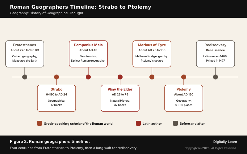
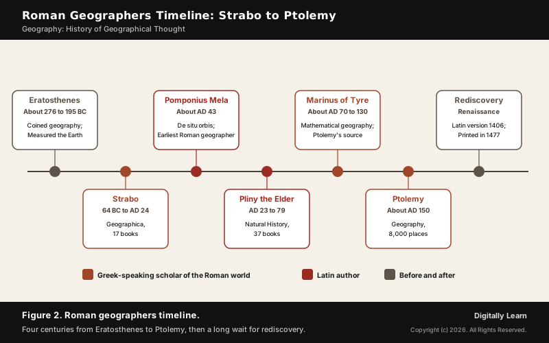
The Roman geographers are the scholars who described and mapped the world under the Roman Empire: the Latin authors Pomponius Mela and Pliny the Elder, and the Greek-speaking Strabo, Marinus of Tyre and Ptolemy. Strabo gave geography its descriptive, regional form; Ptolemy gave it latitude, longitude and map projections.
Roman Geographers: Geography in the Roman World
Who Were the Roman Geographers?
The Roman geographers were of two kinds. Some wrote in Latin, like Pomponius Mela, the earliest known Roman geographer, and Pliny the Elder. Others were Greek-speaking scholars living under Roman rule, like Strabo, Marinus of Tyre and Ptolemy of Alexandria.
The works of almost all earlier geographers are lost, and many are known only through quotations in Strabo. That makes the Roman period one of the most important sources for classical geography. As the empire spread across Europe and the Silk Road opened, knowledge reached the British Isles in the west and, for the first time, the far east.
| Geographer | Main work |
|---|---|
| Strabo (64 BC to AD 24) | Geographica, 17 books of regional description |
| Pomponius Mela (wrote about AD 43) | De situ orbis, a short Latin treatise on geography |
| Pliny the Elder (AD 23 to 79) | Natural History, 37 books; geography in Books 3 to 6 |
| Marinus of Tyre (about AD 70 to 130) | Founded mathematical geography; Ptolemy's main source |
| Ptolemy (about AD 100 to 170) | Geography, about AD 150: coordinates and projections |
Greek Foundations of Roman Geography: Eratosthenes and the Spherical Earth
Roman geography stood on Greek foundations. Eratosthenes of Cyrene, chief librarian at Alexandria, coined the words geography and geographer, was the first known person to calculate the Earth's circumference, and made the first global projection of the world with parallels and meridians.
- Measuring the Earth: At noon on the summer solstice the sun shone straight down a well at Syene (Aswan) and cast no shadow, while at Alexandria a column cast a shadow of about 1/50th of a circle, 7.12 degrees. Knowing the distance between the two cities, he worked out the whole circle.
- A spherical Earth: Pythagoras was perhaps the first to propose it, and Aristotle gave evidence: the curved shadow of the Earth in a lunar eclipse.
- Three continents: The Greeks divided the world into Europe, Asia and Libya (Africa), with a narrow habitable band from the Atlantic to a sea east of India.
Strabo's Geographica: Descriptive and Regional Geography
Strabo's Geographica: 17 Books of Regional Description
Strabo was a Greek geographer from Amaseia in Asia Minor who lived from 64 or 63 BC to about AD 24. He studied in Rome from 44 BC and took notes from the works of his predecessors in the library at Alexandria. His Geographica is an encyclopedia of geographical knowledge in 17 books, written in Greek; a first edition appeared in 7 BC and a final one no later than AD 23.
- Description, not calculation: He cited the astronomers Eratosthenes and Hipparchus, but held that a descriptive approach was more practical, and wrote for statesmen interested in the character of countries and regions.
- Travel as evidence: He wrote that perhaps no geographer had visited more places than he had, from Etruria in the west to the Black Sea and the borders of Ethiopia.
- What survives: The work is almost completely extant, which is why it preserves so much of the lost earlier geography.
- What he rejected: He accepted the narrow band of habitation and dismissed the voyages of Hanno and Pytheas as fables.
Strabo on Land, Sea and India
Strabo defined geography through the coastline: it is the sea above all, he wrote, that gives the land its shape, forming gulfs, straits, isthmuses, peninsulas and promontories, while rivers and mountains assist. From these features we gain a clear idea of continents, nations and the positions of cities.
- A moving Earth: Discussing marine shells found far inland, he argued that the same land is sometimes raised and sometimes depressed, and the sea with it, an idea that the geologist Charles Lyell later admired.
- The Danube: He was the first known to state that the Danouios and the Istros were the upper and lower parts of one river, the Danube.
- India: He never visited it, and mixed fact with fable; his flying reptiles match the Indian flying lizard, but he also wrote of winged scorpions.
- Taprobane: He noted that Sri Lanka sent great amounts of ivory, tortoise-shell and other goods to the markets of India.
Latin Roman Geographers: Pomponius Mela and Pliny the Elder
Pomponius Mela and De Situ Orbis: The First Roman Geographer
Born in southern Spain, Pomponius Mela was the earliest known Roman geographer. He wrote around AD 43 and died about AD 45. His short work, De situ orbis, fills less than a hundred printed pages, yet it stayed in use until nearly 1500 and, apart from the geographical parts of Pliny, is the only formal treatise on geography in classical Latin.
- Five zones: He divided the Earth into five zones, of which only two were habitable, and was unique in asserting people, the antichthones, living in the southern temperate zone, cut off by the heat of the torrid zone.
- A coastal tour: He described the world by following its coasts, from Spain and Gaul round to India, then back through Persia, Arabia and Ethiopia.
- Old errors kept: Like most classical geographers except Ptolemy, he took the Caspian Sea to be an inlet of the Northern Ocean, and he placed India in the south-eastern corner of Asia after Eratosthenes.
Pliny the Elder's Natural History and Its Geography
A Roman author, naturalist and naval and army commander, Pliny the Elder lived from AD 23 to 79. He died at Stabiae while trying to rescue people from the eruption of Vesuvius. His Natural History is the largest single work to survive from the Roman Empire: 37 books, the first 10 published in AD 77.
- Geography in Books 3 to 6: Book 3 covers the Iberian peninsula and Italy, Book 4 Europe, Book 5 Africa and Asia, and Book 6 the Black Sea, India and the Far East.
- A compiler: The work gathers information from other ancient authors and names them, and its list of contents made it a model for later encyclopedias.
- The drain to India: Pliny complained that India, China and the Arabian peninsula took one hundred million sesterces a year from the empire, the cost of Roman luxuries.
Ptolemy and Mathematical Geography
Ptolemy's Geography: Coordinates, Gazetteer and Map Projections
Claudius Ptolemy was a Greco-Roman mathematician, astronomer and geographer who lived in or around Alexandria. His Geography, written in Greek around AD 150, is at once a gazetteer, an atlas and a treatise on cartography, and it revised the lost atlas of Marinus of Tyre, the founder of mathematical geography.
- Book 1: A treatise on cartography: how to assemble the data, why astronomical observations come before travellers’ reports, and how to draw a world map.
- Books 2 to 7: A gazetteer of about 8,000 places, some 6,300 with latitude and longitude, the largest such database from antiquity; Book 7 covers India, China and Sri Lanka.
- End of Book 7: Three projections for drawing the world map, of differing complexity and fidelity.
- Book 8: An atlas of regional maps; the Western standard set had 26: 10 of Europe, 4 of Africa and 12 of Asia.
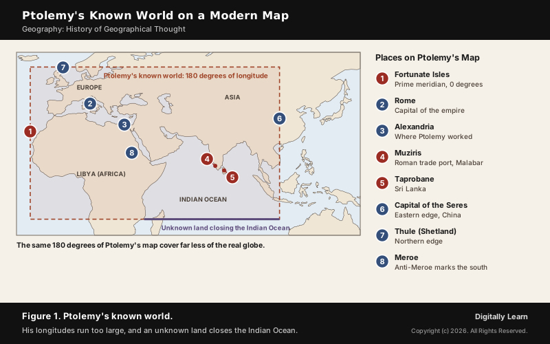
Latitude was measured from the equator, as it is today, and the prime meridian, 0 degrees of longitude, ran through the Fortunate Isles (the Canary Islands), the westernmost land he knew. His known world spanned 180 degrees of longitude to China and about 80 degrees of latitude, and he knew it was only about a quarter of the globe. The equidistant, or simple, conic projection goes back to a prototype by Ptolemy of about AD 150.
Errors in Ptolemy's World Map
Ptolemy's grid was a leap forward, but his numbers carried errors, and they still shaped European maps when his work was printed in 1477.
- Too small an Earth: Instead of Eratosthenes’ 252,000 stadia for the circumference, he used 180,000 stadia, with 500 stadia to a degree.
- Stretched longitudes: The longitudes of well-known cities are too large by a factor of about 1.43, which visibly stretches the shape of Italy on his map.
- An enclosed Indian Ocean: Relying on Hipparchus, he closed the Indian Ocean with an unknown eastern and southern land, making it an inland sea like the Mediterranean.
- A misplaced coast: The coast of China was made to look like an eastern shore of the Indian Ocean.
He also underestimated the width of the oceans. When his work reached Europe, readers understood the world to have three continents, Europe, Asia and Africa, and had no idea how far they would have to sail; Columbus later reckoned that Asia lay much nearer westward than it does.
Ptolemy's Legacy: Arabic Translation and Renaissance Revival
Ptolemy's Geography travelled through three civilisations. Its Arabic translation by al-Khwarizmi in the 9th century shaped the geography and map-making of the Islamic world, and his Almagest reached Arabic scholars through the House of Wisdom in Baghdad.
- Byzantium: The monk Maximus Planudes searched for a copy in 1295, and maps were redrawn from the coordinates in the text.
- Latin: The first Latin translation was made in 1406 or 1407 in Florence.
- Print: In 1477 the Geography, written 1,300 years earlier, became available in print and was widely read.
Roman Practical Geography: Roads, Surveyors and Maps
Roman Road Network, the Groma and Centuriation Grids
The Romans made far more practical use of geography and maps than the Greeks. At its peak, 29 great military highways radiated from Rome, and 372 great roads linked the 113 provinces: more than 400,000 km of road, of which over 80,500 km were paved with stone.
- Gromatici: The cursus publicus, the state transport department, employed full-time surveyors to gather topographical information and find the straightest possible route for a road.
- The groma: A surveying instrument for projecting right angles and straight lines; it is the only Roman surveying tool of which examples survive.
- Centuriation: Land laid out as a regular square grid of roads, canals and plots, often given to army veterans in new colonies.
- Four kinds of surveyor: Land surveyors divided fields and laid out towns, cartographical surveyors made maps, military surveyors measured rivers for crossings, and engineering surveyors prepared the way for roads, canals, aqueducts, tunnels and mines.
Itinerary Maps and the Peutinger Table
Romans travelled with itineraries, lists and diagrams of stations and distances along roads. The Antonine Itinerary is a register of stations and distances along the roads of the empire, possibly based in part on a survey carried out under Augustus.
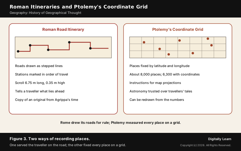
- Peutinger Table: An illustrated road map of the cursus publicus, a parchment scroll 6.75 m long and 0.35 m high in 11 sections, copied around 1200 from a Late Antique original.
- Agrippa’s map: It probably descends from the world map prepared under Marcus Vipsanius Agrippa, engraved in stone and displayed in Rome in the reign of Augustus.
- Not a true map: It leaves out the sea and runs west to east; its aim was to show the road network, like the diagram of an underground railway today.
- India on the scroll: It shows India and the Ganges, Sri Lanka as Insula Taprobane, and a Temple of Augustus at Muziris on the Malabar coast.
- UNESCO: It was inscribed on the Memory of the World Register in 2007.
Roman Geographers and India: Trade, Ports and Contributions
India in Roman Geography: The Periplus, Muziris and Indo-Roman Trade
Roman geographers knew India mainly through trade. The Periplus of the Erythraean Sea, composed by an anonymous Greek sailor in the first century CE, lists what ships took from the Malabar coast: pepper, fine pearls, ivory, silk cloth, diamonds, sapphires and tortoise shell, in exchange for coin, coral, glass, copper, tin and lead.
- The monsoon route: The Periplus says that Hippalus discovered the direct sailing route from the Red Sea across the open ocean to India; merchants chose the times of year that would catch the monsoon winds.
- Scale: By the time of Augustus up to 120 ships sailed each year from Myos Hormos to India.
- Muziris: The Chera port near present Kodungallur appears in the Periplus and in Sangam literature as Muchiri; excavations at Pattanam since 2003-04 have found Roman amphora pieces, Chera coins and pearls.
- Barygaza: Present Bharuch in Gujarat, a harbour the Periplus describes at length, one of a chain of ports that ran from Barbaricum (Karachi) to Arikamedu in Tamil Nadu.
The trade did not last. It declined from the mid-3rd century during a crisis in the Roman Empire, and Tamil-speaking south India turned to Southeast Asia for its international trade, where Indian culture left a much deeper mark.
Contributions of Roman Geographers to Geography
The contributions of the Roman geographers can be grouped under five heads, and each still shapes geography today. Together they turned scattered Greek ideas into a body of knowledge that the Arabs and the Renaissance could inherit.
- Regional geography: Strabo’s description of each land as a whole, its people, places and resources.
- Encyclopedic compilation: Pliny’s gathering of earlier knowledge with named sources and an index.
- Mathematical geography: Marinus and Ptolemy’s latitude, longitude, gazetteer and projections, the base of modern cartography.
- Practical survey: Roads, the groma, centuriation and itineraries, geography put to work for administration.
- Knowledge of Asia: Records of India, Sri Lanka and the trade routes, preserved in the Periplus, Pliny and Ptolemy’s Book 7.
| Point | Strabo | Ptolemy |
|---|---|---|
| Language and base | Greek, Rome and Alexandria | Greek, Alexandria |
| Main work | Geographica, 17 books | Geography, 8 books |
| Method | Description of regions | Coordinates and projections |
| Evidence | Travel and earlier writers | Astronomy before travellers' reports |
| Legacy | Regional geography | Mathematical geography, cartography |
Ptolemy's prime meridian through the Fortunate Isles has since moved to Greenwich; how longitude sets the world's clocks today is explained in time zones and the International Date Line.
Previous Year UPSC-CSE Questions
Previous Year UPSC-CSE Questions By the end you will be able to draft model answers for the following UPSC questions. Each question carries a collapsible framework showing how to approach it in the exam.
- UPSC Prelims 1999 Prelims-GSFrom the third century AD when the Hun invasion ended the Roman Empire, the Indian merchants relied more and more on the
How to approach this Prelims question
Approach: Ask where Indian sea trade went once the Roman market weakened.
Trap to watch: Middle Eastern and West European trade were the old Roman-linked routes, not the new ones.
Key facts to recall:
- Trade declined from the mid-3rd century
- South India turned to Southeast Asia
Answer signal: Southeast Asian trade, option (c).
Sources
- NCERT: Practical Work in Geography Part I (Class XI), Introduction to Maps
- NCERT: Themes in World History (Class XI)
- NCERT: Themes in Indian History I (Class XII), Kings, Farmers and Towns
- UNESCO Memory of the World: Tabula Peutingeriana
- USGS: Map Projections poster
- NOAA National Ocean Service: The History of Geodesy
- Kerala Department of Archaeology: Explorations and Excavations (Muziris, Pattanam)
- Wikipedia: Strabo
- Wikipedia: Geographica
- Wikipedia: Pomponius Mela
- Wikipedia: Pliny the Elder
- Wikipedia: Natural History (Pliny)
- Wikipedia: Ptolemy
- Wikipedia: Geography (Ptolemy)
- Wikipedia: Ptolemy world map
- Wikipedia: Marinus of Tyre
- Wikipedia: Eratosthenes
- Wikipedia: History of geography
- Wikipedia: Tabula Peutingeriana
- Wikipedia: Antonine Itinerary
- Wikipedia: Roman roads
- Wikipedia: Groma (surveying)
- Wikipedia: Centuriation
- Wikipedia: Periplus of the Erythraean Sea
- Wikipedia: Indo-Roman trade relations
- Wikipedia: Taprobane
- UPSC: Civil Services Examination question papers
Editorial Disclaimer
This article draws on the NCERT textbooks, UNESCO, the US Geological Survey, NOAA, the Kerala Department of Archaeology and the other sources listed on this page. Ancient dates are approximate.


