
Overview
Ten biogeographic zones of India
India's only Sundaland territory, its endemic wildlife, and the Rodgers-Panwar classification.
Previous Year UPSC-CSE Questions By the end you will be able to draft model answers for the following UPSC questions. Each question carries a collapsible framework showing how to approach it in the exam.
- UPSC Prelims 2018 General StudiesConsider the following statements:
- The Barren Island volcano is an active volcano located in the Indian territory.
- Barren Island lies about 140 km east of Great Nicobar.
- The last time the Barren Island volcano erupted was in 1991 and it has remained inactive since then.
Which of the statements given above is/are correct?
How to approach this Prelims question
Approach: Three-statement evaluation testing knowledge of Barren Island's geological status and its position within the Andaman-Nicobar archipelago.
Trap to watch: Aspirants may accept Statements 2 and 3 because they sound plausible. The trap is that Barren Island is in the Andaman group (NOT Nicobar) and has erupted repeatedly since 1991.
Key facts to recall:
- Barren Island: India's only active volcano; located in the Andaman group, NOT Nicobar.
- Distance: Approximately 138 km north-east of Port Blair, NOT 140 km east of Great Nicobar.
- Activity: Multiple eruptions after 1991 including 2005, 2017, and later.
- Geological setting: On the Indo-Burma plate boundary, separate from Sundaland.
Answer signal: 1 only
- UPSC Prelims 2013 General StudiesConsider the following fauna of India:
- Gharial
- Leatherback turtle
- Swamp deer
Which of the above is/are endangered?
How to approach this Prelims question
Approach: Three-species evaluation testing recognition of threatened-status across crocodilians, marine reptiles, and ungulates.
Trap to watch: Aspirants may exclude leatherback turtle because of perceived abundance from migratory range. The trap is that leatherback populations have collapsed across the Indo-Pacific.
Key facts to recall:
- Gharial: Gavialis gangeticus; Critically Endangered; Chambal and Mahanadi rivers.
- Leatherback turtle: Dermochelys coriacea; Vulnerable; Galathea Bay nesting.
- Swamp deer: Rucervus duvaucelii; Vulnerable; Dudhwa, Kanha, Kaziranga grasslands.
- Conservation usage: All three are protected under Wildlife Protection Act 1972 Schedule I.
Answer signal: 1, 2 and 3
- UPSC Mains 2019 GS-IAssess the impact of global warming on coral life system with examples.
How to structure the answer in the exam
Introduction: Open by defining the coral life system: a calcified symbiosis between coral animals (Anthozoa) and photosynthetic zooxanthellae algae that builds tropical reef habitats sustaining approximately 25 per cent of marine biodiversity on under 1 per cent of ocean area. Climate change is the primary contemporary threat to this symbiosis.
Body (sub-themes to develop):
- Thermal bleaching: Sustained sea-surface temperatures above 30 degrees Celsius force zooxanthellae expulsion; bleached corals starve and die. Andaman-Nicobar 2010 and 2016 bleaching events documented.
- Ocean acidification: Atmospheric CO2 dissolves into surface ocean and lowers pH, reducing aragonite saturation; coral skeletons calcify slower.
- Sea-level rise: Drowns shallow reef flats; reduces light reaching reef community; alters wave energy balance.
- Cyclone intensification: Stronger cyclones cause increased mechanical damage to coral skeletons.
- Altered current regimes: Disrupt coral larval recruitment and connectivity between reef patches.
- Indian reef examples: Andaman-Nicobar reefs (Sundaland affinity), Gulf of Mannar, Lakshadweep, Gulf of Kachchh (northernmost Indian reefs at thermal edge).
Conclusion: Conclude by noting that India's reef commitments under the Convention on Biological Diversity and the Sustainable Development Goals (SDG 14 Life Below Water) require active management including marine protected area expansion, runoff and sediment control, and global emissions mitigation. Local protective action cannot offset global warming, but it can buy adaptation time for the coral life system to evolve thermal tolerance.
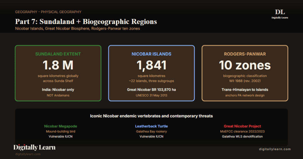
The Sundaland Biodiversity Hotspot is one of the 36 global biodiversity hotspots designated by Conservation International. It spans approximately 1.6 million square kilometres across the Sunda Shelf, covering the Malay Peninsula, Sumatra, Java, Borneo, Bali, and the southernmost Indian territory of the Nicobar Islands. India's Nicobar group consists of approximately 22 islands across a land area of 1,841 square kilometres, organised into Northern, Central, and Southern subgroups. The Andaman Islands are excluded from Sundaland and fall instead within the Indo-Burma hotspot. The Indian Sundaland component centres on the Great Nicobar Biosphere Reserve, declared a UNESCO World Network Biosphere Reserve on 28 May 2013, covering 103,870 hectares and incorporating Campbell Bay National Park and Galathea National Park. The hotspot supports critical leatherback turtle nesting beaches, the Nicobar megapode, and significant coral reef ecosystems threatened by the 2004 tsunami legacy and the proposed Galathea Bay infrastructure development.
Background and Historical Context
The Nicobar Islands hold the highest concentration of biodiversity per unit area of any Indian territory, sit at the geopolitical apex of Indian maritime reach into the Malacca Strait, and host the Shompen and Nicobarese indigenous communities whose welfare is constitutionally guaranteed under the Sixth Schedule equivalent regime for Andaman and Nicobar tribal areas. Beyond the hotspot framing, India's terrestrial biodiversity is organised under the Rodgers-Panwar (1988) classification into ten biogeographic zones, the framework that guides the country's protected-area network design under the Wildlife Institute of India. UPSC has examined Nicobar, Sundaland, and biogeographic-region topics in Prelims 2013, 2014, 2018, 2019, and 2023; recurring GS-I Mains themes include archipelago formation, coral life systems, and tribal community welfare.
What is the significance of the Indian Sundaland component? Three structural features distinguish it. The Nicobar group is geologically isolated from peninsular India by the Andaman Sea but biogeographically tied to South-east Asia through the Sunda Shelf during Pleistocene sea-level lowstands; this drives the Sundaland endemism profile of the islands. The 2004 Indian Ocean tsunami of 26 December caused unprecedented coastal habitat destruction across Nicobar, drowned the southern tip of Indira Point by approximately 4.25 metres, and disrupted indigenous Nicobarese settlements; ecological recovery has been monitored under the WII Nicobar tsunami impact assessment programme. The proposed Great Nicobar development project, centred on the Galathea Bay international container transhipment terminal, an international airport, and a township, ranks among the largest infrastructure decisions affecting an Indian biodiversity hotspot.
The Great Nicobar Development Project received in-principle clearance from MoEFCC in November 2022 and stage-1 forest clearance in October 2023. The Galathea Bay Wildlife Sanctuary, established 1997 specifically for leatherback turtle protection, was denotified by the National Board for Wildlife in January 2021 to free the site for the port. Critics including former environment-secretary EAS Sarma and ecologist Madhav Gadgil have flagged severe ecological costs; supporters cite strategic-maritime priorities in the Bay of Bengal. The Rodgers-Panwar ten-zone framework continues to guide MoEFCC protected-area designation; the Wildlife Institute of India's 2002 revision retained the ten zones with sub-zone refinements rather than overhauling the scheme.
Sundaland Hotspot: Global Extent and India's Component
From the Malay Peninsula to the Nicobar Islands
The Sundaland Biodiversity Hotspot extends across approximately 1.6 million square kilometres of the Sunda Shelf, the shallow continental shelf that emerged as a single landmass during Pleistocene sea-level lowstands. The hotspot covers most of the Malay Peninsula, the major Indonesian islands of Sumatra, Java, Borneo, and Bali, and at its north-western edge, India's Nicobar Islands. The Andamans, geologically distinct and tied to the Burmese arc, fall within the Indo-Burma hotspot examined in Part 4 of this series, not within Sundaland.
The Nicobar group lies geographically closer to Sumatra than to mainland India: Indira Point at the southern tip of Great Nicobar sits only about 150 kilometres from Banda Aceh in Sumatra, while the Indian peninsular mainland is over 1,300 kilometres distant. This proximity drives the Nicobar's Sundaland affinity through migratory bird routes, marine current connectivity, and shared Indo-Pacific reef communities.
Nicobar Islands: Geography and Endemic Wildlife
Twenty-two islands across three groups; 1,841 square kilometres
The Nicobar Islands cover a land area of 1,841 square kilometres across approximately 22 islands organised into three subgroups. The Northern group centres on Car Nicobar, the most populous Nicobar island. The Central group includes Camorta, Katchal, Nancowry, and Trinkat. The Southern group is dominated by Great Nicobar, the largest island and the location of the Galathea National Park, Campbell Bay National Park, and the southernmost tip of India at Indira Point.
- Car Nicobar: Most populous; administrative centre of Nicobar district; tropical evergreen forest with coastal littoral.
- Camorta, Katchal, Nancowry, Trinkat: Central group; significant Nicobarese settlements; affected severely by 2004 tsunami.
- Great Nicobar: Largest Nicobar island (approximately 1,045 sq km); hosts Indira Point, Campbell Bay NP, Galathea NP, and the proposed Great Nicobar Development Project.
- Indira Point: Southernmost tip of India; on Great Nicobar; submerged by approximately 4.25 metres during the 2004 tsunami.
- Barren Island: India’s only active volcano; located approximately 138 kilometres north-east of Port Blair (Andamans, NOT Nicobars); last eruption activity recorded recently.
Iconic endemic fauna: megapode, leatherback turtle, tree shrew
The Nicobar Islands harbour several globally significant endemic vertebrates. The Nicobar megapode (Megapodius nicobariensis) is a chicken-sized ground bird that incubates its eggs in large mounds of decomposing leaf litter rather than by body warmth, and is restricted to the Nicobar group. The leatherback turtle (Dermochelys coriacea) nests across Great Nicobar and Little Nicobar, with the Galathea Bay rookery among the world's most important nesting sites.
- Nicobar megapode: Megapodius nicobariensis; Vulnerable IUCN; restricted to Nicobar group; uses leaf-litter incubation mounds.
- Leatherback turtle: Dermochelys coriacea; Vulnerable IUCN globally; Galathea Bay is among the world’s most important nesting beaches.
- Nicobar tree shrew: Tupaia nicobarica; Endangered; endemic to Nicobar group.
- Nicobar pigeon: Caloenas nicobarica; Near Threatened; widespread across the Sundaland archipelagos.
- Crab-eating macaque: Macaca fascicularis umbrosus; Nicobar subspecies; arboreal and coastal habitat.
Protected Areas and the Great Nicobar Biosphere Reserve
Two national parks core to a UNESCO biosphere reserve
The Indian Sundaland component centres on the Great Nicobar Biosphere Reserve, designated by UNESCO under the World Network of Biosphere Reserves on 28 May 2013. The reserve covers 103,870 hectares and holds two national parks as its core area: Campbell Bay National Park in the north and Galathea National Park in the south. It protects tropical wet evergreen forest, coastal mangroves, and the Galathea Bay leatherback nesting beaches.
| Protected area | Location | Year | Notable feature |
|---|---|---|---|
| Great Nicobar Biosphere Reserve | Great Nicobar Island | UNESCO 28 May 2013 | 103,870 hectares; world network biosphere |
| Campbell Bay National Park | Northern Great Nicobar | Notified 1992 | Tropical wet evergreen forest core area |
| Galathea National Park | Southern Great Nicobar | Notified 1992 | Leatherback turtle nesting beaches |
| Galathea Bay Wildlife Sanctuary | Galathea Bay | Notified 1997; denotified 2021 | Leatherback turtle rookery; denotified for the port project |
| Indira Point Lighthouse | Southernmost tip of India | Active since 1972 | Submerged 4.25 m during 2004 tsunami |
Rodgers-Panwar (1988) Ten Biogeographic Zones of India
The framework that guides Indian protected-area planning
Beyond the hotspot framing, India's terrestrial biodiversity is classified under the Rodgers and Panwar (1988) biogeographic scheme, developed at the Wildlife Institute of India for protected-area network planning. The scheme divides India into ten biogeographic zones, each with distinctive climate, vegetation, soil, and fauna. The 2002 WII revision kept the ten zones and added sub-zone refinements, and MoEFCC uses them to ensure protected-area designation covers every biogeographic unit.
- Trans-Himalayan: Cold desert zones of Ladakh and Spiti north of the main Himalayan range; alpine pastures and barren high-altitude plateau.
- Himalayan: Eastern and Western Himalaya south of the Trans-Himalayan zone; covered in Biodiversity Part 3 of this series.
- Indian Desert: Thar Desert of Rajasthan and adjacent Gujarat; arid grassland, sand dunes.
- Semi-arid: Aravalli foothills, parts of Punjab-Haryana-Gujarat-Maharashtra-Karnataka; scrub forest and rain-shadow Deccan.
- Western Ghats: Sahyadri chain along peninsular India’s western edge; covered in Biodiversity Parts 5 and 6 of this series.
- Deccan Plateau: Largest biogeographic unit; tropical dry deciduous forest; teak-dominated landscapes.
- Gangetic Plain: Indo-Gangetic alluvial flats; agricultural transformation has eliminated most natural vegetation.
- North-East: Seven sister states excluding Sikkim; tropical wet evergreen forest; Indo-Burma hotspot covered in Part 4.
- Coastal: East and west coast strips with mangroves, estuaries, beaches; Sundarbans, Mahanadi delta, Cauvery delta included.
- Islands: Andaman and Nicobar groups plus Lakshadweep; coral reefs, island endemism, marine biodiversity.
Threats: 2004 Tsunami Legacy and the Great Nicobar Project
Coastal habitat destruction and indigenous community displacement
The 2004 Indian Ocean tsunami of 26 December, triggered by the magnitude 9.1 Sumatra-Andaman earthquake, caused unprecedented coastal habitat destruction across the Nicobar Islands. Indira Point, the southernmost tip of India, subsided by approximately 4.25 metres, coastal villages were destroyed, and the Nicobarese community lost over a thousand members.
- Reef damage: Coral reefs suffered both direct wave damage and later bleaching from the warming pulse that followed.
- Nesting disruption: The submergence reshaped beach geometry, disturbing leatherback turtle nesting sites.
- Slow recovery: Wildlife Institute of India monitoring recorded partial vegetation recovery over the following decade, but lasting coastal change.
Great Nicobar Development Project: the largest contemporary biodiversity-policy contest
The Great Nicobar Development Project is the largest infrastructure decision affecting an Indian biodiversity hotspot. It envisages an international container transhipment terminal at Galathea Bay, a greenfield airport, a township, and supporting works across roughly 16,610 hectares of Great Nicobar. The site was freed by the January 2021 denotification of the Galathea Bay Wildlife Sanctuary, the leatherback rookery protected since 1997.
- Clearances: In-principle MoEFCC clearance in November 2022; stage-1 forest clearance in October 2023.
- Conservation cost: Loss of the dedicated leatherback turtle sanctuary and reef habitat along the south coast.
- Tribal concern: The Shompen, a particularly vulnerable hunter-gatherer group, hold constitutionally protected interests in the affected interior.
- Expert critique: Former environment-secretary EAS Sarma and ecologist Madhav Gadgil have flagged severe and irreversible ecological costs.
Prelims MCQ practice
Each question below tests one specific concept on the topic. Click to reveal the answer and a full option-wise explanation.
Q1. Consider the following statements regarding the Sundaland Biodiversity Hotspot:
- The hotspot covers approximately 1.6 million square kilometres.
- India's Nicobar Islands form the north-western edge of the hotspot.
- The Andaman Islands are part of the Sundaland hotspot.
Which of the statements given above is/are correct?
- 1 only
- 1 and 2 only
- 2 and 3 only
- 1, 2 and 3
Show answer and explanation
Answer: 1 and 2 only
Explanation.
Statement 1 is correct: Sundaland covers approximately 1.6 million sq km across the Sunda Shelf. Statement 2 is correct: Nicobar Islands form the hotspot's north-western edge. Statement 3 is INCORRECT: the Andaman Islands fall within the Indo-Burma hotspot, NOT Sundaland; Andamans are geologically tied to the Burmese arc, NOT to the Sunda Shelf. The correct answer is option two.
Q2. With reference to the Nicobar Islands, consider the following:
- Total land area is approximately 1,841 square kilometres.
- The islands are organised into Northern, Central, and Southern groups.
- Indira Point on Great Nicobar is the southernmost tip of India.
Which of the statements given above is/are correct?
- 1 only
- 1 and 2 only
- 2 and 3 only
- 1, 2 and 3
Show answer and explanation
Answer: 1, 2 and 3
Explanation.
All three statements are correct. Statement 1: total area approximately 1,841 sq km. Statement 2: three subgroups (Northern, Central, Southern). Statement 3: Indira Point on Great Nicobar is the southernmost tip of India. The correct answer is option four.
Q3. Consider the following statements about the Great Nicobar Biosphere Reserve:
- UNESCO designated it under the World Network of Biosphere Reserves on 28 May 2013.
- It covers approximately 103,870 hectares.
- Campbell Bay National Park and Galathea National Park are the core areas of the reserve.
Which of the statements given above is/are correct?
- 1 only
- 1 and 2 only
- 2 and 3 only
- 1, 2 and 3
Show answer and explanation
Answer: 1, 2 and 3
Explanation.
All three statements are correct per UNESCO and MoEFCC records. Statement 1: UNESCO designation 28 May 2013. Statement 2: 103,870 hectares. Statement 3: Campbell Bay NP and Galathea NP form the core area. The correct answer is option four.
Q4. With reference to the Rodgers-Panwar biogeographic classification of India, consider the following:
- The scheme divides India into ten biogeographic zones.
- It was developed at the Wildlife Institute of India.
- Andaman and Nicobar Islands fall within the Islands zone.
Which of the statements given above is/are correct?
- 1 only
- 1 and 2 only
- 2 and 3 only
- 1, 2 and 3
Show answer and explanation
Answer: 1, 2 and 3
Explanation.
All three statements are correct. Statement 1: ten biogeographic zones. Statement 2: developed at the Wildlife Institute of India. Statement 3: Andaman and Nicobar plus Lakshadweep all fall within the Islands zone. The correct answer is option four.
Q5. With reference to the 2004 Indian Ocean tsunami impact on Nicobar Islands, consider the following:
- The tsunami was triggered by a magnitude 9.1 Sumatra-Andaman earthquake on 26 December 2004.
- Indira Point at the southernmost tip of India submerged by approximately 4.25 metres.
- The Nicobarese indigenous community lost over a thousand members.
Which of the statements given above is/are correct?
- 1 only
- 1 and 2 only
- 2 and 3 only
- 1, 2 and 3
Show answer and explanation
Answer: 1, 2 and 3
Explanation.
All three statements are correct. Statement 1: magnitude 9.1 earthquake; 26 December 2004. Statement 2: Indira Point submerged by approximately 4.25 m. Statement 3: Nicobarese community lost over a thousand members. The correct answer is option four.
Q6. Consider the following statements about the Great Nicobar Development Project:
- The project envisages an international container transhipment terminal at Galathea Bay.
- MoEFCC granted in-principle clearance in November 2022 and stage-1 forest clearance in October 2023.
- It is built on land freed by the 2021 denotification of the Galathea Bay Wildlife Sanctuary, established 1997 for leatherback turtle protection.
Which of the statements given above is/are correct?
- 1 only
- 1 and 2 only
- 2 and 3 only
- 1, 2 and 3
Show answer and explanation
Answer: 1, 2 and 3
Explanation.
All three statements are correct per MoEFCC clearances and official records. Statement 1: international transhipment terminal at Galathea Bay. Statement 2: MoEFCC in-principle November 2022; stage-1 forest October 2023. Statement 3: the Galathea Bay Wildlife Sanctuary, established 1997 for leatherback turtle protection, was denotified by the National Board for Wildlife in January 2021 ahead of the port. The correct answer is option four.
Sources and Further Reading
- NCERT Class 11 India: Physical Environment, Chapter 5 – Natural Vegetation
- Wikipedia – Sundaland
- Wikipedia – Nicobar Islands
- Wikipedia – Great Nicobar Biosphere Reserve
- Wikipedia – Biogeographic classification of India
- Wikipedia – Nicobar megapode
- Wikipedia – Leatherback sea turtle
- Wikipedia – Shompen people
- Wikipedia – 2004 Indian Ocean earthquake and tsunami
- Wikipedia – Galathea National Park
- Wikipedia – Biodiversity hotspot
Disclaimer
This article is intended for UPSC preparation. Conservation statuses, areas, and clearances may change with official notifications, so verify time-sensitive figures against primary sources before the examination.


