


Overview
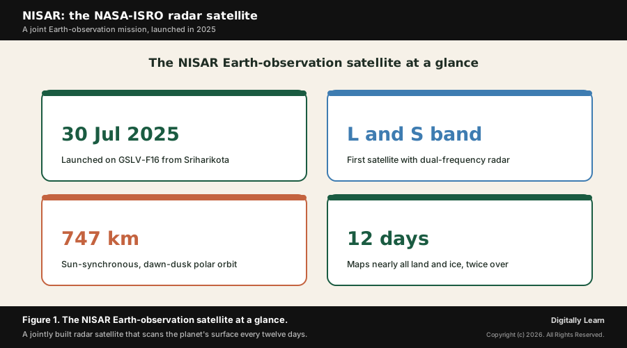
NISAR, short for the NASA-ISRO Synthetic Aperture Radar, is an Earth-observation satellite built jointly by the Indian Space Research Organisation and the United States space agency NASA. Launched on 30 July 2025 on the GSLV-F16 rocket from Sriharikota, it is the first satellite to carry a dual-frequency radar, working in both the L-band and the S-band. From a polar orbit about 747 km high, NISAR scans nearly all of the planet's land and ice surfaces every twelve days, measuring how the ground and the ice move, day and night and through cloud.
ISRO and NASA Launch a Joint Earth-Observation Radar
A dual-band radar satellite, launched on a GSLV
India and the United States have placed in orbit one of the most advanced Earth-observation satellites ever built. Known as NISAR, the NASA-ISRO Synthetic Aperture Radar, it was launched on 30 July 2025 aboard the GSLV-F16 rocket from the Satish Dhawan Space Centre at Sriharikota.
NISAR is described by ISRO as a first-of-its-kind mission, jointly developed by ISRO and NASA. It is the first satellite to carry radar in two frequencies at once, an L-band radar and an S-band radar, which together let it study the surface in finer and more varied detail than a single-band instrument could.
Weighing about 2,400 kilograms, the satellite carries a large folding antenna, draws around five kilowatts of power, and circles the Earth roughly fourteen times a day from a polar orbit about 747 km high. The figure below sets out the mission at a glance.
Why NISAR Is in the News: The Science Phase Begins
From commissioning to full science operations
Why it matters now is that NISAR has moved from launch into routine science. After lift-off the mission ran a roughly ninety-day commissioning phase, during which engineers unfolded the antenna, switched on the two radars and checked that the data met the required standard.
With commissioning complete, NISAR has begun its planned science mission, of at least three years, returning a steady stream of radar images of the world's land and ice. Because the data are open and free, scientists, planners and disaster managers in India and abroad can use them as soon as they are released, which is why the start of operations is closely watched.
Understanding the Significance of NISAR for India
A leap in observing capability and a milestone in cooperation
What is the significance of NISAR lies in the leap it gives India in observing its own land. A radar that can measure ground and ice motion to about a centimetre, in all weather, day and night, is a powerful tool for a country exposed to earthquakes, landslides, floods and the slow sinking of crowded cities.
The mission is also a landmark in India-US space cooperation, the most ambitious civil-space project the two countries have undertaken together. For ISRO it proves the maturity of its large unfurlable antenna, its boom and its S-band radar electronics, capabilities that strengthen India's wider Earth-observation programme.
How NISAR Works: Dual-Band SAR, SweepSAR and Interferometry
Synthetic aperture radar and the two frequencies
NISAR sees the surface using synthetic aperture radar, or SAR. Unlike an ordinary camera, a radar sends its own microwave pulses and listens for the echo, so it can image at night and see through cloud, smoke and light rain. By combining the echoes gathered as the satellite flies along, the radar behaves as if it had a far larger antenna, which sharpens the image.
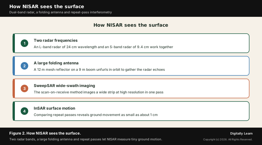
What makes NISAR unusual is that it carries two radars at once. The L-band radar, with a wavelength of about 24 cm, penetrates vegetation and soil and is well suited to forests, biomass and ground motion. The S-band radar, with a wavelength of about 9.4 cm, contributed by ISRO, is more sensitive to lighter vegetation and crops. Reading the surface in two wavelengths reveals features that one band alone would miss.
| Radar band | Wavelength | Built by | Best suited to |
|---|---|---|---|
| L-band SAR | About 24 cm | NASA | Forests, woody biomass, soil and ground deformation |
| S-band SAR | About 9.4 cm | ISRO | Lighter vegetation, crops and agricultural monitoring |
Read together, the two rows show why a dual-band radar is more powerful than a single-band one: the longer L-band and the shorter S-band respond to different features, so the mission captures a fuller picture of the same surface.
The folding antenna and the SweepSAR wide-swath method
To collect enough radar energy, NISAR carries a 12 m mesh reflector, a folding dish-like antenna that unfurled in orbit at the end of a 9 m boom. A large reflector lets a radar see a wide strip of ground in a single pass while keeping the detail fine.
The mission uses a technique called SweepSAR, a scan-on-receive method that images a wide swath without sacrificing resolution. In effect the radar listens across the whole width of the beam as it sweeps, so each pass covers a broad band of the surface. This is how NISAR can map nearly all of the planet's land and ice in just twelve days.
Interferometry: measuring motion between repeat passes
The most striking capability comes from comparing images of the same place taken on different passes, a method called radar interferometry, or InSAR. Tiny differences between two radar images reveal how much the ground has risen or sunk in between, down to roughly one centimetre.
Because NISAR repeats its coverage every twelve days, it builds a steady record of how the surface deforms over time. This is exactly what is needed to watch a fault before an earthquake, a slope before a landslide, a volcano as it inflates, or a city as it sinks over pumped-out groundwater. The figure below summarises how the radar works.
What NISAR Will Observe: Ecosystems, Ice, Earthquakes and Cities
Four domains the mission was built to study
NISAR was designed around a few clear scientific goals, each of direct use to India. Together they cover the living surface, the frozen surface, the moving solid Earth and the hazards that affect people, so the satellite reads the planet as a single changing system.
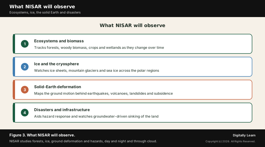
- (a) Ecosystems and biomass. Tracking forests, woody and above-ground biomass, crop extent and wetlands, which supports forestry, agriculture and the carbon account.
- (b) Ice and the cryosphere. Watching ice sheets, mountain glaciers and sea ice, of close interest for the Himalaya and for India’s Antarctic research.
- (c) Solid-Earth deformation. Mapping the ground motion behind earthquakes, volcanoes, landslides and the rise or fall of the land.
- (d) Disasters and infrastructure. Supporting hazard response, and watching the slow subsidence of cities as groundwater is drawn down.
Read together, these uses make NISAR a working tool for disaster management and planning, not only a research instrument. The figure below names the four domains.
Why these capabilities matter for India
For India the applications are immediate. The country sits across active seismic belts, faces frequent landslides in the Himalaya and the Western Ghats, and loses ground each year to floods and to land that sinks as aquifers are emptied. A radar that maps these changes every twelve days, in any weather, is a genuine advance for early warning and response.
In farming, the two radar bands help map crop area and growth and monitor soil moisture and wetlands, feeding better estimates of production. In the high mountains, repeat radar images track glaciers and glacial lakes, where sudden outburst floods threaten downstream valleys. The figure below sets out what NISAR will observe.
NISAR in Context: India-US Space Cooperation and ISRO's Fleet
Open data, a growing Earth-observation fleet and a partnership
Contemporary linkages tie NISAR to several wider stories. It is the flagship of a deepening India-US space partnership, in which NASA built the L-band radar and ISRO built the S-band radar, the spacecraft bus and the launch, and the two agencies share the science.
NISAR also joins ISRO's wider Earth-observation fleet, alongside the RISAT radar satellites, the Cartosat mapping satellites and the Resourcesat series, deepening India's ability to watch its own territory. Where earlier radar satellites carried a single band, NISAR's two bands and its open, free data set it apart.
The open-data policy connects to a broader shift in which space agencies release Earth-observation data freely so that the widest possible community, in research, government and industry, can put it to use. For India it complements the push to use space technology for governance and development, from crop insurance to flood mapping.
Finally, NISAR sits within the long arc of India's space programme, which has moved from launch vehicles and communication satellites to deep-space missions and now to a frontier Earth-observation mission built shoulder to shoulder with a leading space power.
UPSC Relevance and Exam Focus
Where this fits in the UPSC-CSE syllabus
This topic maps to General Studies Paper III: science and technology, developments in space, and disaster management, with links to the application of technology in governance and to India's foreign relations in the field of space.
For Prelims, hold the high-yield facts: NISAR is a joint NASA-ISRO mission, the first satellite with dual L-band and S-band synthetic aperture radar, launched on a GSLV from Sriharikota, in a sun-synchronous polar orbit, with a twelve-day repeat and open data.
For Mains, the recurring framing is how space-based remote sensing strengthens disaster management, agriculture and resource monitoring, and how international cooperation advances India's technological capability. NISAR is a ready example of all three.
Recurring linked concepts an aspirant should keep in working memory:
- Synthetic aperture radar (SAR): An active radar that images day and night and through cloud by synthesising a large antenna.
- Interferometry (InSAR): Comparing repeat radar passes to measure ground motion to about a centimetre.
- Sun-synchronous orbit: A near-polar orbit that crosses each place at a fixed local solar time, ideal for steady Earth observation.
- Hazard zonation mapping: Classifying terrain by its risk of landslides or other hazards as a basis for preparedness.
A common Prelims trap is to assume an optical satellite, which needs sunlight and a clear sky. NISAR is a radar mission: it provides its own illumination and sees through cloud, so it works in any weather, day or night.
A common Mains trap is to treat NISAR only as a science satellite. Its real exam value is as an applied tool for disaster preparedness, hazard mapping and agriculture, the very themes the disaster-management questions reward.
Previous Year UPSC-CSE Questions By the end you will be able to draft model answers for the following UPSC questions. Each question carries a collapsible framework showing how to approach it in the exam.
- UPSC Mains 2019 GS-IIIDisaster preparedness is the first step in any disaster management process. Explain how hazard zonation mapping will help disaster mitigation in the case of landslides.
How to structure the answer in the exam
Body (sub-themes to develop):
- Disaster preparedness is the first, proactive step: it shifts disaster management from reaction to anticipation, the framing of the current government approach.
- Hazard zonation mapping divides terrain into zones of high, moderate and low landslide susceptibility using slope, geology, rainfall and past failures.
- For landslides, zonation guides land-use control, slope stabilisation, drainage works, early-warning siting and the routing of roads and settlements away from high-risk zones.
- Modern Earth-observation radar such as NISAR strengthens zonation by measuring slow slope deformation to about a centimetre on a twelve-day repeat, flagging unstable slopes before failure.
- Open, all-weather, day-and-night radar data feed continuously updated hazard maps and early-warning systems for vulnerable hill regions.
Sources and Further Reading
- ISRO: GSLV-F16 / NISAR mission page
- NASA Science: NISAR mission overview
- NASA Science: NASA-ISRO's NISAR mission by the numbers
- NASA: NASA-ISRO satellite lifts off to track Earth's changing surfaces
- NASA JPL: NISAR mission
- Wikipedia: Synthetic-aperture radar
- Wikipedia: Interferometric synthetic-aperture radar
- Wikipedia: Sun-synchronous orbit
Editorial Disclaimer
This briefing is for UPSC preparation. Verify the figures and mission details against the official ISRO and NASA sources before relying on them.


