


Overview
India's first geosynchronous imaging satellite
EOS-05, also called GISAT-1A, is an Indian Earth observation satellite launched on GSLV-F17 on 4 September 2026. It is India's first imaging satellite built to watch the Earth from geosynchronous orbit, about 36,000 km up, from where it can image a selected area every five minutes and the whole of India every 30 minutes.
EOS-05 Launch on GSLV-F17: Why It Is in the News
GSLV-F17 Mission: Launch Date, Satellite Mass and Transfer Orbit
The rocket lifted off from the Second Launch Pad of the Satish Dhawan Space Centre and placed the 2,367 kg satellite in the intended orbit about 18 minutes later. It was the 19th flight of the Geosynchronous Satellite Launch Vehicle (GSLV) and the 107th launch from Sriharikota. EOS-05 is also the heaviest satellite a GSLV has carried: the first GSLV, D1, flew with a payload of 1,536 kg, and ISRO Chairman V. Narayanan credited the gain to a lighter structure and better propulsion.
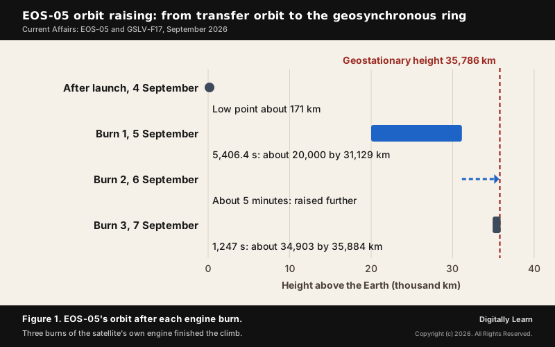
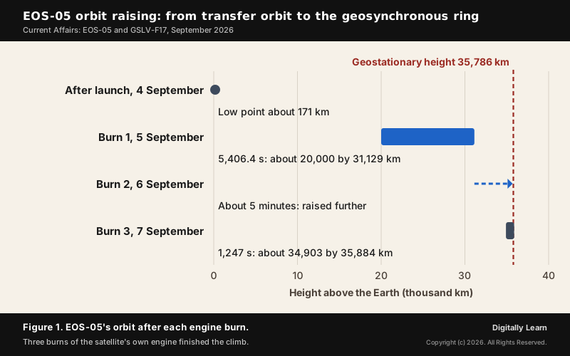
The rocket did not take the satellite all the way. It released EOS-05 into a sub-geosynchronous transfer orbit (sub-GTO), a long ellipse whose low point was only about 171 km above the Earth and whose high point lay far out towards the geosynchronous ring. Finishing the climb was the satellite's own job, and the first data from orbit showed its valves working and its solar panel deployed.
Orbit Raising: Three Liquid Apogee Motor Burns to Geosynchronous Orbit
A satellite raises its own orbit with an onboard engine, here the Liquid Apogee Motor (LAM). Each burn changes the far side of the ellipse, so the satellite climbs in steps rather than in one go.
- First burn, 5 September: The LAM fired for 5,406.4 seconds, about 90 minutes, and finished at 8.19 p.m. It lifted the orbit to roughly 20,000 km by 31,129 km.
- Second burn, 6 September: A short firing of about five minutes raised the orbit further, towards the geostationary height of about 35,786 km.
- Third burn, 7 September: The LAM fired for 1,247 seconds and left EOS-05 in an orbit of about 34,903 km by 35,884 km. Its health was to be checked for some days before the imaging systems were switched on.
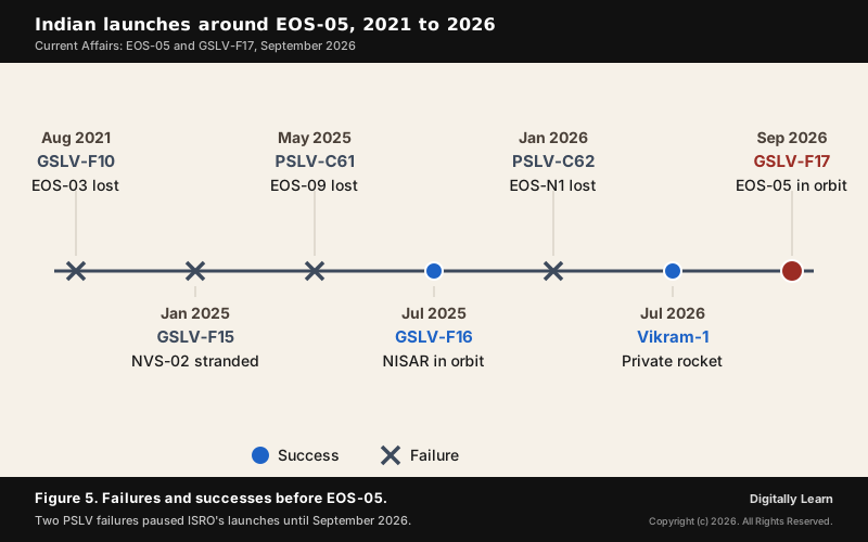
ISRO's stated target is the 85.5 degrees East orbital slot, a point on the equator south of the Bay of Bengal from which the satellite keeps the whole of India in view. The burns matter as much as the launch. In January 2025 the navigation satellite NVS-02 reached its transfer orbit safely but was stranded there, because the valves that admit oxidiser to its main engine did not open.
Why the Launch Matters: First Success After the PSLV Failures
ISRO had not launched since 12 January 2026, when PSLV-C62 failed while carrying the EOS-N1 Earth observation satellite. That was the second failure of its workhorse rocket in a row: PSLV-C61, carrying EOS-09, had failed on 18 May 2025, and both were traced to anomalies in the third stage. Seven missions planned for the first quarter of 2026, EOS-05 among them, did not fly while the agency took a cautious approach.
The launch also closed an older chapter. EOS-05 is the replacement for EOS-03, or GISAT-1, which was lost on 12 August 2021 when the cryogenic third stage of GSLV-F10 failed to ignite. The same kind of upper stage that ended the first attempt carried the second one to orbit, which is why the success was read as a vote of confidence in the cryogenic stage.
The pause was ISRO's alone: Skyroot Aerospace's privately built Vikram-1 rocket was launched successfully on 18 July 2026. Even so, two successive PSLV failures show that a record of dependability is not a guarantee, and a space agency is finally judged by how often it flies and how useful its satellites are.
What EOS-05 (GISAT-1A) Carries: Telescope, Sensors and Revisit
I-2K Bus and the 700 mm Ritchey-Chretien Telescope
EOS-05 is built on ISRO's I-2K satellite bus, a proven platform, so the new part of the mission is the camera it carries. That camera is a 700 mm Ritchey-Chretien telescope based on the design used on Cartosat-2A, with detector arrays in the visible and near-infrared and in the short-wave infrared.
A telescope sees less detail the farther it is from its target. From 36,000 km the same mirror covers a far larger patch of ground than it would from a few hundred kilometres, so from geosynchronous orbit the size of the mirror sets how much ground detail the camera can show.
Multispectral and Hyperspectral Imaging: Six, 158 and 256 Channels
Unlike an ordinary camera, the sensors measure how strongly the ground reflects light at different wavelengths. Vegetation, water and other kinds of land cover each reflect light in their own pattern, so splitting the light into bands is what lets an image tell them apart.
| Sensor set | Channels | Wavelength range | Ground resolution |
|---|---|---|---|
| Multispectral, visible and near-infrared | 6 | 0.45 to 0.875 micrometres | 42 m |
| Hyperspectral, visible and near-infrared | 158 | 0.375 to 1.0 micrometres | 318 m |
| Hyperspectral, short-wave infrared | 256 | 0.9 to 2.5 micrometres | 191 m |
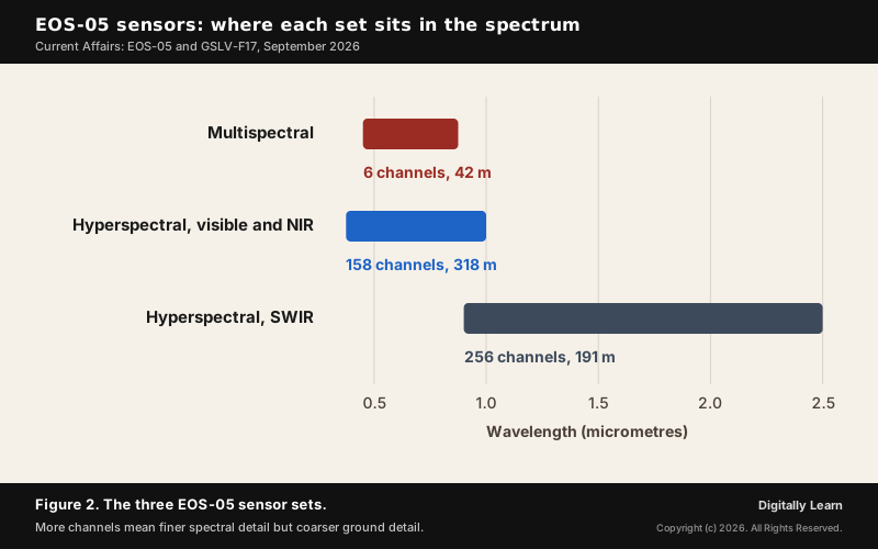
A multispectral sensor records a few broad bands; a hyperspectral sensor records hundreds of narrow ones. Materials that look the same in a broad band can be separated when their reflectance is sampled in many narrow slices, because each absorbs light at its own wavelengths. This is how the sensors help distinguish vegetation, water and other land cover, which is the basis of every use described below.
Revisit Time: a Selected Area Every Five Minutes, India Every Thirty
The mission is designed to image a selected area about every five minutes and the entire Indian landmass about every 30 minutes at 42 m resolution. Those two figures are the reason the satellite exists.
A low-orbit satellite photographs a strip as it passes, moves on, and returns to the same place only after days. If cloud covers the target on that pass, the next clear image may be days away, and a cyclone, a flood crest or a fire front can change completely in that gap. A satellite that looks every half hour turns imaging from a survey into a watch.
Geostationary vs Geosynchronous Orbit: The Difference Explained
Geosynchronous Orbit and Geostationary Orbit: Meaning and Height
A geosynchronous orbit is any orbit whose period equals one rotation of the Earth, one sidereal day. A satellite in such an orbit returns to the same position in the sky at the same time each day, but the orbit may be tilted to the equator or slightly oval.
A geostationary orbit is the special geosynchronous orbit that is circular and lies in the plane of the equator. Only then does the satellite appear fixed over one point on the ground. Its height works out to about 35,786 km, which is 22,236 miles, usually rounded to 36,000 km, and its radius from the Earth's centre is 42,164 km.
- Every geostationary orbit is geosynchronous: It has the one-day period.
- Not every geosynchronous orbit is geostationary: A tilted or oval one-day orbit makes the satellite trace a small path in the sky each day instead of staying still.
- Three conditions make an orbit geostationary: A one-day period, a circular shape, and a position in the equatorial plane.
ISRO calls EOS-05 a geosynchronous imaging satellite, and its orbit after the third burn, about 34,903 km by 35,884 km, was close to the geostationary ring but not exactly on it. UPSC has tested the conditions above more than once. The questions have been solved completely, with explanations, in the Previous Year Questions section.
Geosynchronous Satellite vs Low Earth Orbit Satellite: Resolution and Revisit
Most imaging satellites fly in low orbits a few hundred kilometres up, many of them in a sun-synchronous orbit, which crosses each place at the same local time so that successive images have similar light. A polar satellite 500 to 800 km up takes about 100 minutes per orbit, so it sees the Earth strip by strip, one strip a pass.
| Feature | Sun-synchronous (low orbit) | Geostationary |
|---|---|---|
| Height | About 700 to 900 km | About 36,000 km |
| Coverage | A strip on each pass; 81 degrees north to 81 degrees south | About one-third of the globe at once |
| Orbital period | About 14 orbits a day | 24 hours |
| Resolution | Fine | Coarse |
| Typical uses | Earth resources | Telecommunication and weather |
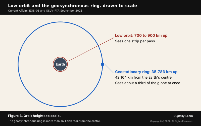
EOS-05 changes the last row of that table: it puts an Earth-resources instrument in the orbit that was used for weather and communication. Its 42 m is coarse beside the sharpest low-orbit imagery, but it is far finer than the kilometre-scale pixels of a weather imager, and it can look again within minutes.
India's Geostationary and Geosynchronous Satellites: INSAT and NavIC
India has watched the Earth from geostationary orbit for decades, but with weather satellites, the INSAT-3D series, and with the INSAT communication satellites used for telecommunications and broadcasting. Its dedicated imaging satellites, from the IRS series onward, have all flown in low, polar or sun-synchronous orbits.
The navigation system NavIC, the Indian Regional Navigation Satellite System, shows why an orbit may be geosynchronous without being geostationary. Its design places three satellites in geostationary orbit and four in inclined geosynchronous orbits. The inclined ones swing north and south of the equator each day, which spreads the satellites across the sky over India and improves a position fix. NavIC serves India and a region up to 1,500 km beyond its borders. As of March 2026 only three NavIC satellites could provide positioning service, below the four needed for an accurate fix, because atomic clocks had failed and NVS-02 never reached its orbit.
Uses of EOS-05: Disasters, Agriculture, Stubble Fires and Security
Cyclones, Floods, Cloudbursts and Glacial Hazards
The satellite's first uses are hazards that change within hours: cyclones, floods, cloudbursts and forest fires. From 85.5 degrees East the whole Bay of Bengal, the Arabian Sea and the Himalayan arc lie in view at once, so a storm or a rising river can be followed through the day instead of being pieced together from occasional passes.
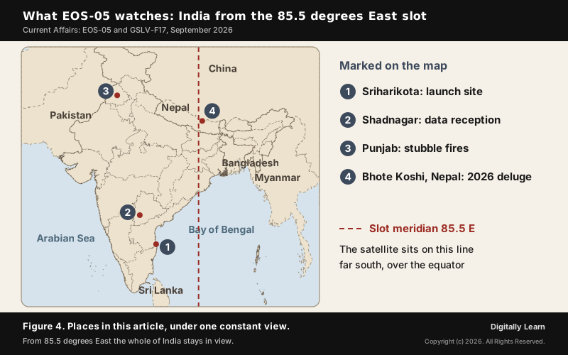
The timing of the launch made the point. A glacial and mountain collapse on the China-Nepal border on 26 August 2026 set off the Bhote Koshi deluge in Nepal, which had claimed 1,344 lives by 7 September. Frequent images of the same slopes can show changes in landforms that may come before glacier breaks and avalanches, which is the kind of early sign a satellite that returns only after days can miss.
Crops, Water Bodies and the Stubble-Burning Timing Problem
Slower changes matter too: crop condition, forest cover, the extent of water bodies and patterns of land use. During the monsoon, cloud defeats optical satellites, and a sensor that looks every 30 minutes has a far better chance of catching a clear moment over a district than one that passes every few days.
Stubble burning in Punjab shows the problem exactly. Fire counts have come from satellites in polar orbits that pass over India during the day, and a study by ISRO's Space Applications Centre found that peak burning shifted from about 1.30 p.m. in 2020 to around 5 p.m. in 2024, after those passes. On 3 September 2026 the Commission for Air Quality Management said it was working with ISRO on better ground-truthing of farm fires.
Maritime Awareness and Strategic Data From a Constant View
ISRO describes EOS-05 as a strategic satellite, a word that stretches from security to weather. A constant view over the northern Indian Ocean helps track activity at sea in a way that periodic passes cannot: knowing within the hour that something has changed over a wide area tells a sharper satellite or patrol where to look.
All of this depends on the data reaching enough analysts who can turn images into forecasts and decisions. Under the Indian Space Policy 2023, ISRO data with a ground sampling distance of 5 m or coarser is to be made available on a free and open basis, so imagery at EOS-05's 42 m falls in the open category. In India, satellite data is received at the earth station at Shadnagar near Hyderabad, corrected for errors and then interpreted into maps and tables for users.
India's Earth Observation Satellites and Launch Vehicles
From IRS to the EOS Series: Cartosat, RISAT and Oceansat
Indian Earth observation began with the Indian Remote Sensing (IRS) satellites; the programme to send polar satellites into space began in the late 1980s. The later families each specialise: Cartosat carries high-resolution cameras for mapping, RISAT carries synthetic aperture radar that images in all weather, through cloud, and Oceansat observes the sea.
ISRO now names its Earth observation satellites in one EOS sequence across these families, so the name no longer tells you the instrument. EOS-01 was RISAT-2BR2, EOS-04 was RISAT-1A and EOS-06 is Oceansat-3; EOS-05 carries the older name GISAT-1A, for Geo Imaging Satellite. Earlier families also had IRS numbers: Oceansat-1 was IRS-P4, Cartosat-1 was IRS-P5 and Cartosat-2 was IRS-P7.
PSLV vs GSLV vs LVM3: Roles, Stages and the Cryogenic Upper Stage
India's launch vehicles divide the work by orbit. The Polar Satellite Launch Vehicle (PSLV) has carried Earth resources and remote sensing satellites to low and sun-synchronous orbits, while the GSLV was built mainly to put communication satellites into geosynchronous transfer orbit. The division is a tendency, not a rule: GSLV-F16 carried the joint ISRO-NASA radar satellite NISAR to a sun-synchronous orbit on 30 July 2025.
| Vehicle | Stages | Typical job |
|---|---|---|
| PSLV | Four stages, solid and liquid used alternately | Low and sun-synchronous orbits |
| GSLV | Three stages, with a cryogenic upper stage | Geosynchronous transfer orbit; heavier low-orbit payloads |
| LVM3 (earlier GSLV Mk III) | Two S200 solid boosters, an L110 liquid core and a C25 cryogenic upper stage | Heaviest Indian payloads; chosen for the Venus Orbiter Mission |
A cryogenic stage burns liquid hydrogen and liquid oxygen, propellants that must be kept extremely cold, and it has been the hardest stage for ISRO to master. On GSLV-F10 in 2021 a low hydrogen tank pressure at ignition made the stage's fuel booster turbo pump misbehave, and the stage never fired properly.
ISRO After the Indian Space Policy 2023: Reforms and the Staff Debate
Roles of ISRO, NSIL, IN-SPACe and the Department of Space
The Indian Space Policy 2023 divides the work of the space sector among four public bodies and opens the whole value chain to private firms. Its central instruction to ISRO is to move away from manufacturing operational systems and hand mature systems to industry.
| Body | Role under the Indian Space Policy 2023 |
|---|---|
| ISRO | Research and development of new space technologies and applications; human spaceflight; transfers mature systems to industry and stops manufacturing operational systems; open access to remote sensing data |
| NSIL (NewSpace India Limited) | Public sector undertaking under the Department of Space; commercialises space technologies and platforms built with public money |
| IN-SPACe | Autonomous single-window agency that promotes and authorises space activities by government and non-government entities |
| Department of Space | Nodal department for the policy; ensures continuous Earth observation capability and resolves disputes |
The split matters for a mission like EOS-05. ISRO designs and proves new systems; once a system is mature, its production is meant to pass to industry, with NSIL selling it and IN-SPACe licensing private operators, while the Department of Space keeps the duty to ensure that the country never runs short of Earth observation data.
ISRO Employee Associations' Letter and the Privatisation Debate
On the day of the launch, 4 September, nine ISRO employee associations wrote to the ISRO Chairman asking whether the government means to transfer the agency's launch-vehicle and satellite manufacturing to private firms. They cited a remark by IN-SPACe chairman Pawan Kumar Goenka on 21 August that ISRO would eventually not make launch vehicles, and asked about sanctioned posts, recruitment over the next five to ten years, and consultation before irreversible decisions.
Dr. Goenka replied on 6 September, followed by a longer clarification from ISRO. He said ISRO's role was "by no means diminishing" and that industry would scale mature rockets and satellites while ISRO concentrated on advanced research and missions such as the Bharatiya Antariksh Station by 2035 and a crewed lunar mission by 2040. ISRO called talk of privatisation baseless, said ownership of critical space infrastructure would stay with the government, and pointed to over 450 space start-ups and a plan to grow the roughly $8.4 billion space economy to $44 billion by 2033.
Neither reply addressed the narrower worry about posts and recruitment. Department of Space employees cannot form trade unions, because they are exempt from the statutory definition of industry; they organise instead as service associations recognised under the Central Civil Services (Recognition of Service Associations) Rules, 1993.
Space Technology for Development or Prestige: The Larger Question
The dispute raises an older question about what the space programme is for. It was founded to use space technology for social development rather than to join space races, and EOS-05's stated uses, from disaster warning to crop monitoring, sit inside that tradition.
The shift is clearly inspired by NASA, which has itself shrunk since the 1960s: from 0.7 per cent of American GDP in 1966 to 0.1 per cent now, and from 36,000 civil servants at the peak of Apollo to about 14,000. Its budget of $24.4 billion is 16 times that of the Department of Space, ₹13,705 crore. Unlike early NASA, ISRO has always built with private manufacturers such as Walchandnagar and L&T.
India in Global Space Cooperation and the Limits of EOS-05
International Space Summit in Paris: ESA, CNES and India
Days after the launch, India's space leadership was at the International Space Summit in Paris. The European Space Agency already has a Technical Implementing Plan with ISRO to give ground-station support to Gaganyaan, which aims to fly a crew of three to a 400 km orbit for three days, and the two agencies were exploring cooperation on lunar exploration and the Venus Orbiter Mission. That mission, approved at ₹1,236 crore, is to leave the Earth on 29 March 2028 on an LVM3 and reach Venus on 19 July 2028 after 112 days.
France's space agency CNES said it still fully trusts ISRO despite the PSLV failures; the joint TRISHNA satellite, which will map the Earth's surface temperature, is due to fly on a PSLV next year. Prime Minister Narendra Modi told the summit that more than 430 satellites from 34 countries have flown on Indian rockets, citing Chandrayaan-3, Aditya-L1 and an Indian astronaut's visit to the International Space Station in 2025, and set the goals of an Indian space station by 2035 and an Indian on the Moon by 2040.
Limits of EOS-05: Resolution, Data Use and Launch Cadence
Geostationary imaging is not new worldwide. China has flown Gaofen 4, an optical imaging satellite in geostationary orbit with 50 m visible resolution, since 28 December 2015. What is new is India placing a land-imaging instrument there rather than a weather sensor.
- Coarse detail: At 42 m a building is invisible and a small field is a single pixel, so tasks that need to identify objects stay with low-orbit satellites, and seeing through cloud stays with radar.
- Data use: A picture of India every 30 minutes is useful only if it is processed and reaches forecasters, disaster managers and farm departments before the next one arrives.
- Launch cadence: One clean GSLV flight after two PSLV failures settles little on its own; the test of the coming year is how many missions fly and reach their orbits.
EOS-05 for UPSC: Syllabus Links and Exam Angles
EOS-05 in the UPSC Syllabus: GS Paper III Space Technology
EOS-05 belongs to General Studies Paper III, awareness in the field of space, and to disaster management in the same paper. The staff debate and the Indian Space Policy 2023 add a governance angle, and state PCS papers ask the same facts on launch vehicles and orbits.
- Facts to fix: 4 September 2026; GSLV-F17, the 19th GSLV flight; 2,367 kg; GISAT-1A; the 85.5 degrees East slot; six multispectral channels at 42 m; a selected area every five minutes, India every 30.
- Concepts to explain: Geosynchronous against geostationary orbit, the transfer orbit and orbit raising, multispectral against hyperspectral sensing, and resolution against revisit.
- Mains uses: Space technology for disaster management and agriculture, the stubble-fire timing problem, and the roles of ISRO, NSIL and IN-SPACe.
Previous Year UPSC-CSE Questions By the end you will be able to draft model answers for the following UPSC questions. Each question carries a collapsible framework showing how to approach it in the exam.
- UPSC Mains 2016 GS-IIIDiscuss India’s achievements in the field of Space Science and Technology. How the application of this technology has helped India in its socio-economic development?
Answer outline: how to structure the answer
What the question asks, the main arguments, relevant examples and the direction of the conclusion. This is not a full model answer.
Introduction: Open with the founding aim of the Indian space programme, space technology for social development rather than prestige, and cite EOS-05 (4 September 2026) as its latest instance.
Body (sub-themes to develop):
- Launch capability: PSLV for low and sun-synchronous orbits; GSLV with a cryogenic upper stage for geosynchronous transfer orbit (EOS-05, 2,367 kg, its heaviest payload); LVM3 for the heaviest.
- Satellites: IRS to the EOS series (Cartosat mapping, RISAT radar, Oceansat sea); INSAT weather and communication; NavIC navigation; EOS-05 imaging India every 30 minutes.
- Exploration and cooperation: Chandrayaan-3, Aditya-L1, Gaganyaan; over 430 foreign satellites launched on Indian rockets.
- Development uses: cyclone and flood warning, crop and water monitoring, the stubble-fire timing problem, maritime awareness; open data at 5 m and coarser under the 2023 policy.
- Delivery: Space Policy 2023 roles of ISRO, NSIL and IN-SPACe; over 450 start-ups; the debate on keeping development at the centre.
Conclusion: Conclude that India's space programme has turned technical gains into public services, and that its value now depends as much on getting data to users as on launching satellites.
- UPSC Prelims 2011 Prelims-GSSatellites used for telecommunication relay are kept in a geostationary orbit. A satellite is said to be in such an orbit when:
- The orbit is geosynchronous.
- The orbit is circular.
- The orbit lies in the plane of the Earth’s equator.
- The orbit is at an altitude of 22,236 km.
Select the correct answer using the codes given below:
How to approach this Prelims question
Approach: Step 1: statement 1, the orbit is geosynchronous: correct, a geostationary orbit has the one-day period. Step 2: statement 2, the orbit is circular: correct. Step 3: statement 3, the orbit lies in the equatorial plane: correct. Step 4: statement 4, an altitude of 22,236 km: incorrect, 22,236 is the height in miles; in kilometres it is about 35,786. So 1, 2 and 3 only.
Trap to watch: The number 22,236 is real, but it is in miles. Read the unit before marking a height correct.
Key facts to recall:
- (a) 1, 2 and 3 only: right. A geostationary orbit is geosynchronous, circular and equatorial.
- (b) 1, 3 and 4 only: wrong. It leaves out the circular shape and includes the wrong altitude.
- (c) 2 and 4 only: wrong. It leaves out two true conditions and keeps the wrong altitude.
- (d) 1, 2, 3 and 4: wrong. Statement 4 gives the height in miles as kilometres.
Answer signal: 1, 2 and 3 only: option (a), the official answer.
- UPSC Prelims 2018 Prelims-GSWith reference to the Indian Regional Navigation Satellite System (IRNSS), consider the following statements:
- IRNSS has three satellites in geostationary and four satellites in geosynchronous orbits.
- IRNSS covers entire India and about 5500 sq. km beyond its borders.
- India will have its own satellite navigation system with full global coverage by the middle of 2019.
Which of the statements given above is/are correct?
How to approach this Prelims question
Approach: Step 1: statement 1, three geostationary and four geosynchronous satellites: correct, that is the design. Step 2: statement 2, about 5500 sq. km beyond the borders: incorrect, the service area extends about 1,500 km, a distance, beyond the borders. Step 3: statement 3, full global coverage: incorrect, the system is regional by design. So 1 only.
Trap to watch: The word Regional in the system's name settles statement 3, and a service area is given as a distance from the border, not as square kilometres.
Key facts to recall:
- (a) 1 only: right. Only the orbit split is correct.
- (b) 1 and 2 only: wrong. The coverage beyond the borders is about 1,500 km, not 5500 sq. km.
- (c) 2 and 3 only: wrong. Both statements are incorrect, and statement 1, which is correct, is left out.
- (d) None: wrong. Statement 1 is correct.
Answer signal: 1 only: option (a), the official answer.
- UPSC Prelims 2018 Prelims-GSWith reference to India's satellite launch vehicles, consider the following statements:
- PSLVs launch the satellites useful for Earth resources monitoring whereas GSLVs are designed mainly to launch communication satellites.
- Satellites launched by PSLV appear to remain permanently fixed in the same position in the sky, as viewed from a particular location on Earth.
- GSLV Mk III is a four-staged launch vehicle with the first and third stages using solid rocket motors; and the second and fourth stages using liquid rocket engines.
Which of the statements given above is/are correct?
How to approach this Prelims question
Approach: Step 1: statement 1, PSLV for Earth resources and GSLV mainly for communication satellites: correct. Step 2: statement 2, PSLV satellites appear fixed in the sky: incorrect, only a geostationary satellite appears fixed; PSLV payloads in low orbits cross the sky in minutes. Step 3: statement 3, GSLV Mk III is four-staged: incorrect, it has two solid boosters, a liquid core and a cryogenic upper stage. So 1 only.
Trap to watch: Four stages belong to the PSLV, not to GSLV Mk III, and appearing fixed in the sky is a property of the geostationary orbit, not of a launch vehicle.
Key facts to recall:
- (a) 1 only: right. Only the division of roles is correct.
- (b) 2 and 3: wrong. PSLV satellites do not appear fixed, and LVM3 is not four-staged.
- (c) 1 and 2: wrong. Statement 2 is incorrect.
- (d) 3 only: wrong. Statement 3 is incorrect and statement 1 is correct.
Answer signal: 1 only: option (a), the official answer.
Sources
- ISRO: GSLV-F17/EOS-05 Mission
- ISRO: Orbit manoeuvring of EOS-05 spacecraft (5 September 2026)
- PIB: Prime Minister lauds ISRO for the successful launch of GSLV-F17 carrying EOS-05
- Department of Space: Indian Space Policy 2023
- PIB: Indian Space Policy 2023 opens the sector to non-government entities
- NCERT: Physics Part I (Class XI), Chapter 8, Gravitation: Geostationary and Polar Satellites
- NCERT: Practical Work in Geography Part I (Class XI), Chapter 7, Introduction to Remote Sensing
- The Hindu, Delhi, 4 September 2026: Air quality panel taps ISRO to improve tracking of Punjab, Haryana farm fires
- The Hindu, Delhi, 5 September 2026: ISRO launches advanced imaging satellite EOS-05
- The Hindu, Delhi, 6 September 2026: Why does India need a common time reference? (IST Rules, 2026)
- The Hindu, Delhi, 7 September 2026: Steady gaze (editorial); ISRO's role is by no means diminishing: space officials
- The Hindu, Delhi, 8 September 2026: Ground control (editorial)
- The Hindu, Delhi, 9 September 2026: Have complete trust in ISRO: French space agency
- The Hindu, Delhi, 10 September 2026: ESA to hold talks with ISRO on human spaceflight and lunar exploration
- The Hindu, Delhi, 11 September 2026: Focus on cooperation over confrontation in space: PM
- Wikipedia: EOS-05
- Wikipedia: List of GSLV launches
- Wikipedia: Geostationary orbit
- Wikipedia: Geosynchronous orbit
- Wikipedia: Indian Regional Navigation Satellite System
- Wikipedia: NVS-02
- Wikipedia: PSLV-C62
- Wikipedia: EOS-09
- Wikipedia: NISAR (satellite)
- Wikipedia: Vikram (rocket)
- Wikipedia: LVM3
- Wikipedia: Polar Satellite Launch Vehicle
- Wikipedia: Geosynchronous Satellite Launch Vehicle
- Wikipedia: Gaofen
- Wikipedia: EOS-01
- Wikipedia: EOS-04
- Wikipedia: Oceansat-3
- Wikipedia: Oceansat-1
- Wikipedia: Cartosat-1
- Wikipedia: Cartosat-2
- UPSC: Civil Services Examination question papers
Editorial Disclaimer
This article draws on the ISRO mission pages, the Indian Space Policy, NCERT and the other sources listed on this page.


