


Overview
Weather-ready and climate-smart India
Mission Mausam is India's national mission to make the country weather-ready and climate-smart. Approved by the Union Cabinet on 11 September 2024 with ₹2,000 crore over two years and launched on 14 January 2025, it is run by the Ministry of Earth Sciences through the India Meteorological Department, IITM Pune and NCMRWF, and expands India's radars, supercomputers, forecast models and warnings.
Mission Mausam: Approval, Launch, Outlay and Aims
Cabinet Approval, Outlay and Implementing Institutes
The Union Cabinet approved the mission on 11 September 2024 with an outlay of ₹2,000 crore over two years, and the Prime Minister launched it on 14 January 2025. Its goal is to make India a weather-ready and climate-smart nation, by greatly expanding how the country observes, understands, models and forecasts weather and climate.
- Ministry: The Ministry of Earth Sciences (MoES) implements it.
- Lead institutes: The India Meteorological Department (IMD), the Indian Institute of Tropical Meteorology (IITM), Pune, and the National Centre for Medium Range Weather Forecasting (NCMRWF), Noida.
- Supporting institutes: The Indian National Centre for Ocean Information Services (INCOIS), the National Centre for Polar and Ocean Research and the National Institute of Ocean Technology, with academia and industry.
- Mission period: The first phase was set for 2024‑26; the government told Parliament in March 2026 that the mission runs in phases until 2031.
As approved by the Cabinet, the mission covers monsoon forecasts, alerts for air quality, extreme weather and cyclones, weather interventions for managing fog, hail and rain, and capacity building and awareness. Its critical elements are next-generation radars and satellite systems, high-performance supercomputers, improved Earth system models and a GIS-based automated Decision Support System for real-time dissemination.
Targets and Progress: Radars, Profilers, Testbeds and Weather Management
The mission set out its observation targets in September 2024: 50 Doppler Weather Radars, 60 radiosonde and radiowind stations, 100 disdrometers, 10 wind profilers, 25 radiometers, an urban testbed, a process testbed, an ocean research station and 10 marine automatic weather stations with upper-air observation.
By July 2026 IMD was receiving data from 50 Doppler radars run by IMD, other MoES institutes and ISRO, and the network was being expanded with 29 C‑band, 45 X‑band and 12 S‑band radars, 19 wind profilers, 25 microwave radiometers and 60 new GPS radiosonde stations. In January 2026, with 47 radars working, 87 per cent of the country's area was under radar coverage.
- Mahabaleshwar radar: On 24 April 2026 IITM opened an X‑band dual-polarisation Doppler radar at about 1,400 m in the Western Ghats, giving nowcasts up to three hours ahead over Satara, Pune and parts of Konkan.
- Atmospheric Research Testbed: An observatory at Silkheda in Sehore district, Madhya Pradesh, in the monsoon core zone, studies monsoon convection, cloud microphysics and rainfall variability.
- Weather management: The mission develops technologies and protocols to manage fog, hail and rain. Cloud seeding, one such method, disperses substances such as silver iodide into the air to serve as nuclei for cloud droplets or ice, to change the amount or type of precipitation.

Weather Forecasting in India: Timescales, Models and Radars
Types of Weather Forecasting and Numerical Weather Prediction
Weather forecasts are grouped by how far ahead they look, and the mission works on every range.
- Nowcast: The present weather and a forecast for the next few hours, issued district by district on a map and renewed about every three hours.
- Short and medium range: Forecasts for the coming days; IMD issues district warnings five days ahead.
- Extended range and seasonal: Outlooks further ahead, up to the whole monsoon season.
Modern forecasts come from numerical weather prediction, which uses mathematical models of the atmosphere and oceans to predict the weather from current conditions. Observations are first fed into the model through data assimilation, and the calculations need some of the world's most powerful supercomputers. IMD's global forecast system and NCMRWF's Mithuna system run at a 12 km grid.
The Bharat Forecast System (BharatFS), developed by IITM Pune and dedicated on 26 May 2025, runs at 6 km on a Triangular Cubic Octahedral grid, finer than the 9 to 14 km of typical global models. It was built to give forecasts for a cluster of panchayats and to predict extremes better, and in research mode it forecast extreme rainfall about 30 per cent more accurately than the previous model.
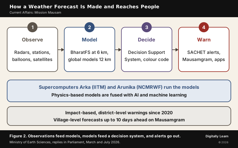
The Arka supercomputer at IITM and Arunika at NCMRWF have raised the ministry's computing power, cutting the BharatFS runtime from about 12 hours to 3 to 6 hours so that it can run in real time, and the mission fuses physics-based models with artificial intelligence and machine learning. The accuracy of severe-weather forecasts has improved by 40 per cent over the previous decade.
Doppler Weather Radars and the Observation Network
A Doppler weather radar locates precipitation, calculates its motion and estimates its type, whether rain, snow or hail. Most modern weather radars are pulse-Doppler radars, which detect the motion of rain droplets as well as how intense the rain is, so they show the structure of a storm as it develops.
- Dual polarisation: Shows cloud microphysics, such as drop size and the structure of a storm, and sharpens estimates of how much rain is falling.
- Blind spots in mountains: A radar works by sending out and receiving beams, and mountains block them, so the rugged areas most prone to cloudbursts are often poorly covered.
- Non-weather targets: Insects carried by the wind and migrating birds also return echoes, which is why radar is used to study bird migration.
Radars are one part of a wider network. Between the end of 2014 and the end of 2025, automatic weather stations grew from 675 to 1,008, rain gauge stations from 3,500 to 6,726 and runway visual range systems at airports from 20 to 186, while a lightning location network was built at 104 places. Satellites add the view from above.
Impact-Based Forecasting and IMD's Colour-Coded Warnings
IMD Colour Codes: Green, Yellow, Orange and Red Warnings
Since 2020 IMD has issued impact-based forecasts and risk-based warnings at the district level, using colour codes. An impact-based forecast tells people not only what the weather will be but what harm it may do, so that district authorities can act before it arrives.
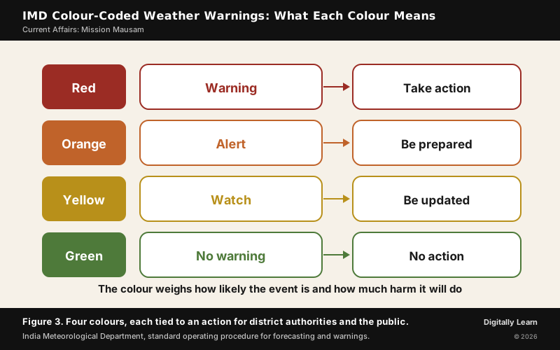
The colour is not set by the amount of rain alone. Forecasters weigh the probability of the event together with its likely impact, and a district already in flood can be given orange or red for rain that would be yellow elsewhere. IMD's own Decision Support System, built in India and in use since 2023, issues these warnings on a GIS platform; by April 2026 its impact-based warnings reached nearly 80 per cent of the population, and the system had halved the time needed to prepare a forecast and made its forecasts about 30 per cent more accurate.
Reaching People: SACHET Alerts, Mausamgram and Weather Apps
A warning saves lives only if it reaches people in time. IMD generates alerts in the Common Alerting Protocol, and state disaster management authorities send them by SMS to people in the affected area through SACHET, the platform of the National Disaster Management Authority; Google and Apple also carry the feeds.
- Scale: By January 2026, 9,342 crore SMS alerts had been sent since August 2021, 77.64 crore of them during cyclone Montha.
- Mausamgram: Village-level forecasts by PIN code or gram panchayat, hourly for 36 hours, three-hourly for five days and six-hourly for 10 days.
- Other channels: The MAUSAM, MEGHDOOT and DAMINI mobile apps, television, radio and social media, with sector-specific advisories for farmers and disaster managers.
The results show in the death toll. About 7,000 people died in the 1999 Odisha super cyclone; in recent years the death toll from tropical cyclones has fallen below 100. The government estimates that an accurate forecast of one cyclone saves about ₹1,100 crore in ex gratia, evacuation and losses to sectors such as power, shipping, aviation and railways.
Cloudbursts and the Limits of Weather Forecasting
Cloudburst Meaning, Formation and Why It Is Hard to Forecast
IMD defines a cloudburst as 10 cm or more of rain in an hour over a small area of about 20 to 30 sq km. Because so much water falls so fast, the ground cannot absorb it and sudden floods follow; some scientists also use the term "mini-cloudburst" for 5 cm in an hour.
- Formation: Warm, moist air rises fast; in mountains the monsoon winds are forced up the slopes, which is orographic lifting. The rising air cools and condenses into cumulonimbus clouds up to 15 km tall.
- The burst: Strong updrafts hold the raindrops aloft until their weight is too great or the updrafts weaken, and the water falls at once.
- Where and when: Most strike the Himalaya during the monsoon, when moist clouds from the Bay of Bengal or the Arabian Sea are driven against the mountains. Uttarakhand, Himachal Pradesh, and Jammu and Kashmir have reported a surge of such events, especially in July and August.
- Frequency: IMD recorded only about 30 cloudbursts between 1970 and 2016, an undercount because most occur in remote, high places with few gauges; a warming atmosphere holds more moisture and is making them more frequent.
Cloudbursts are among the hardest events to forecast. A model's grid cell is larger than the area of a cloudburst, the event builds within hours, and mountains block radar beams and have few weather stations. Nowcasting and the mission's denser radar network and AI aim to narrow the gap, though a cloudburst will remain harder to predict than an ordinary storm. The label itself needs care. In the 2025 Dharali floods in Uttarakhand the rain rate was later found to be below the cloudburst threshold, and construction on riverbeds, deforestation and poor drainage did much of the damage.
Mission Mausam and Disaster Management: From Relief to Preparedness
Three Stages of Disaster Management and the NDMA
Disaster management has three stages. Before a disaster it means data on hazards, vulnerability maps, awareness, planning, preparedness and prevention; during a disaster, rescue and relief such as evacuation, shelters, food, water and medical aid; and after it, rehabilitation, recovery and capacity building for the next event.
The earlier approach, which UPSC calls reactive, concentrated on the second stage, relief after the event. The Disaster Management Act, 2005, set up the National Disaster Management Authority (NDMA), headed by the Prime Minister, to frame policies and guidelines and work with the state authorities, and the stress has since moved to the first stage. Forecasting is the backbone of that stage, and the need is large, since about two-thirds of India's area, and a similar share of its people, are vulnerable to disasters.
| Stage | Earlier stress | Present stress, with Mission Mausam |
|---|---|---|
| Before the event | Little advance warning | District colour-coded warnings five days ahead; nowcasts for storms |
| During the event | Rescue and relief | Evacuation planned from cyclone landfall forecasts; SMS alerts to the area |
| After the event | Rehabilitation only | District hazard and vulnerability maps for planning and capacity building |
The benefits reach well beyond disasters. The Cabinet named agriculture, defence, environment, aviation, water resources, power, tourism, shipping, transport, energy and health; INCOIS's ocean advisories and potential fishing zone maps serve fishermen, and better monsoon forecasts guide crop planning and irrigation.
Mission Mausam in the UPSC Syllabus: GS Paper III and Disaster Management
Weather Services and Disaster Management in the UPSC and PCS Syllabus
Mission Mausam belongs to General Studies Paper III, under science and technology and disaster management, and to the climate topics of Paper I. State PCS papers ask about the same national missions and IMD warnings.
- Prelims facts: Ministry of Earth Sciences; Cabinet approval 11 September 2024; ₹2,000 crore over two years; launched 14 January 2025; IMD, IITM and NCMRWF; BharatFS at 6 km; four warning colours.
- Concepts: Nowcast, numerical weather prediction, data assimilation, Doppler and dual-polarisation radar, impact-based forecasting, cloud seeding, cloudburst.
- Mains analysis: The shift from relief to preparedness, early warning and the last mile, and the limits of forecasting in mountains.
Previous Year UPSC‑CSE Questions
Each Prelims question is explained option by option, and each Mains question comes with an answer outline.
- UPSC Prelims 2026Which of the following statements with regard to India's indigenous new high resolution weather model, the 'Bharat Forecast System,' is/are correct?
- Its objective is to generate forecasts at the Panchayats cluster level.
- It was developed by IIT Delhi.
Select the answer using the code given below:
How to approach this Prelims question
Approach: Test each statement against the model's stated aim and its developer.
- Step 1: Statement 1: BharatFS was developed to generate forecasts at the level of a cluster of panchayats; correct.
- Step 2: Statement 2: It was developed by the Indian Institute of Tropical Meteorology, Pune, not IIT Delhi; wrong.
Only statement 1 is correct.
Trap to watch: IITM Pune and IIT Delhi sound alike; the model came from IITM, an institute of the Ministry of Earth Sciences.
Why each option is right or wrong:
- (a) 1 only: Correct. Its aim is forecasts for a cluster of panchayats, and IITM Pune developed it.
- (b) 2 only: Wrong. IIT Delhi did not develop it, and statement 1 is true.
- (c) Both 1 and 2: Wrong. Statement 2 is false.
- (d) Neither 1 nor 2: Wrong. Statement 1 is true.
Answer: (a) 1 only.
- UPSC Mains 2024 GS‑IWhat is the phenomenon of 'cloudbursts'? Explain.
Answer outline
The outline sets out what the question asks, the main arguments, relevant examples and the direction of the conclusion; it is not a full model answer.
Introduction: A cloudburst is 10 cm or more of rain in an hour over about 20 to 30 sq km, as IMD defines it.
Body (sub-themes to develop):
- Formation: Rapid rise of warm, moist air; orographic lifting on mountain slopes; cumulonimbus up to 15 km; updrafts hold drops until they fall at once.
- Where: The Himalaya in July and August; Uttarakhand, Himachal Pradesh and Jammu and Kashmir.
- Forecasting: Smaller than a model grid cell, builds within hours, radar blind spots in mountains; nowcasting and Mission Mausam's radars help.
Conclusion: Land use and drainage decide how much damage a cloudburst does.
- UPSC Mains 2022 GS‑IDiscuss the meaning of colour-coded weather warnings for cyclone prone areas given by India Meteorological Department.
Answer outline
Introduction: Since 2020 IMD has issued impact-based forecasts and risk-based warnings at the district level, in four colours.
Body (sub-themes to develop):
- The four colours: Green, no warning, no action; yellow, watch, be updated; orange, alert, be prepared; red, warning, take action.
- How a colour is chosen: The probability of the event weighed with its impact; a flooded district can get orange or red for rain that is yellow elsewhere.
- For cyclone-prone areas: Warnings guide evacuation planning and the SACHET SMS alerts sent to the area; cyclone deaths have fallen sharply since 1999.
Conclusion: The colours turn a forecast into a clear instruction for authorities and the public.
- UPSC Mains 2020 GS‑IIIDiscuss the recent measures initiated in disaster management by the Government of India departing from the earlier reactive approach.
Answer outline
Introduction: Disaster management runs in three stages, before, during and after an event, and about two-thirds of India's area is vulnerable to disasters.
Body (sub-themes to develop):
- Law and institutions: The Disaster Management Act, 2005, and the NDMA headed by the Prime Minister, with state authorities.
- Early warning: Mission Mausam (₹2,000 crore, 2024), 50 Doppler radars by July 2026, BharatFS at 6 km, impact-based colour-coded district warnings since 2020.
- Last mile: SACHET alerts (9,342 crore SMS, August 2021 to January 2026), Mausamgram village forecasts, hazard and vulnerability maps.
- Results: Cyclone deaths down from about 7,000 in 1999 to fewer than 100 in recent years; about ₹1,100 crore saved per accurate cyclone forecast.
- Limits: Mountain blind spots, cloudbursts too small for model grids, and warnings that must reach the most vulnerable.
Conclusion: India now acts before disasters strike; forecasting and the last mile decide how far that shift reaches.
Sources
- Press Information Bureau: Cabinet approves Mission Mausam, 11 September 2024
- Press Information Bureau: Mission Mausam unveiled, 13 September 2024
- Press Information Bureau: Mission Mausam backgrounder, 23 December 2024
- Press Information Bureau: Parliament reply on the upgradation of the observation network, 29 January 2026
- Press Information Bureau: Parliament reply on Mission Mausam, 11 March 2026
- Press Information Bureau: Parliament reply on the implementation of Mission Mausam, 23 July 2026
- Press Information Bureau: Parliament reply on weather forecasting and early warnings, 23 July 2026
- Press Information Bureau: Parliament reply on the early warning system, 1 April 2026
- Press Information Bureau: India's Multi-Hazard Early Warning Decision Support System, 2 April 2026
- Press Information Bureau: X‑band Doppler Weather Radar at Mahabaleshwar, 26 April 2026
- Press Information Bureau: Bharat Forecast System dedicated to the nation, 26 May 2025
- Press Information Bureau: Parliament reply on the Bharat Forecast System, 7 August 2025
- India Meteorological Department: Weather Forecasting and Warning Services, standard operating procedure
- India Meteorological Department: Integrated Urban Meteorological Services, Delhi
- NCERT: India Physical Environment (Class XI), Chapter 6, Natural Hazards and Disasters
- Wikipedia: Numerical weather prediction
- Wikipedia: Weather radar
- Wikipedia: Cloud seeding
- Wikipedia: Cloudburst
- Wikipedia: National Disaster Management Authority (India)
- Wikipedia: Project Mausam
- The Hindu: Why cloudbursts are hard to forecast (31 July 2026)
- UPSC: Civil Services Examination question papers
Editorial Disclaimer
This article draws on the Press Information Bureau, the India Meteorological Department, the current NCERT geography textbook, The Hindu and Wikipedia.
See more of our UPSC articles in Google Search
Add to Preferred Sources

