


Overview
The 2023 Sikkim disaster and India's mitigation response
A glacial lake outburst flood, or GLOF, is the sudden release of a glacial lake when its natural moraine or ice dam fails, a climate-driven mountain hazard now central to India's disaster management.
A Glacial Lake Outburst Flood (GLOF) is the sudden, catastrophic release of water from a glacial lake when the natural dam holding it back gives way. The dam may be a wall of loose rock and debris, a moraine left behind by a retreating glacier, or a barrier of ice. Its failure can be set off by an avalanche or landslide crashing into the lake, by ice breaking from a glacier, by a moraine collapse, an earthquake or an intense cloudburst, sending a fast, sediment-laden flood racing down the valley. As climate change shrinks Himalayan glaciers, their meltwater lakes are growing in number and size, so the risk to downstream dams, roads and settlements is rising. The South Lhonak Lake disaster in Sikkim in October 2023 brought this danger into sharp national focus.
What Is a Glacial Lake Outburst Flood: Dam Types and Triggers
A glacial lake, a fragile dam and a sudden release
A Glacial Lake Outburst Flood, or GLOF, is the sudden release of a large volume of water from a lake fed by glacier meltwater. As a glacier retreats, it leaves a hollow that fills with water, held in place by a natural barrier. When that barrier fails, the lake empties in minutes rather than days, and the water surges downstream as a destructive flood.
The barrier is of two main kinds. A moraine-dammed lake sits behind a wall of loose rock and debris bulldozed up by the glacier; this material is unconsolidated and can give way once water seeps through or overtops it. An ice-dammed lake is held by a wall of glacier ice, which can melt, float or collapse. Neither barrier was built to hold water safely, which is why both can fail without warning.
What sets off the failure of a glacial lake dam
A GLOF usually needs a trigger, a sudden event that pushes the dam past its limit. The most common is a mass of rock, ice or earth falling into the lake. The chief triggers, recognised in disaster-management literature, are these:
- (a) Avalanche or landslide. A mass of snow, ice or rock plunges into the lake, sending a wave over the dam that scours and breaches it.
- (b) Ice fall or glacier calving. A block of ice breaks from the glacier into the lake, raising the water level abruptly and overtopping the barrier.
- (c) Moraine collapse or seepage. Water working through the loose moraine weakens it from within until the dam fails.
- (d) Earthquake. Ground shaking destabilises the dam or shakes loose the rock and ice above the lake.
- (e) Cloudburst or intense rain. A sudden downpour fills the lake or loosens a slope above it, forcing the dam to overtop.
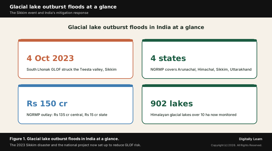
Whatever the trigger, the outcome is similar: a breach in the dam releases the lake at speed, and the flood carries huge quantities of rock and sediment that magnify the damage far downstream. The figure below sets the disaster in context.
Why GLOFs Are in the News: South Lhonak and the National Project
A Sikkim disaster and a national mitigation project
Why it matters now is that GLOFs have moved from a specialist concern to a front-line disaster-management priority. On the night of 3 to 4 October 2023, a GLOF from South Lhonak Lake in North Sikkim sent a wall of water down the Teesta river, causing severe destruction in the valley below and a tragic loss of life. It was among the most damaging mountain disasters India has seen in recent years.
The event forced a national response. To reduce the risk of a repeat, the Central Government approved the National GLOF Risk Mitigation Project, and agencies began urgent work to assess high-risk lakes and install early-warning systems. The disaster also sharpened a wider debate about building dams, roads and townships in a young and unstable mountain range as the climate warms.
Understanding the Significance of GLOFs for India
A climate-change disaster that tests proactive risk management
What is the significance of glacial lake outburst floods lies first in what they reveal about a warming Himalaya. As glaciers retreat, their meltwater lakes grow in number and size, so a slow, almost invisible change in the high mountains can turn, in minutes, into a sudden flood that reaches towns and dams far below. The hazard is a direct, downstream expression of climate change.
Their second significance is what they demand of the State. GLOFs strike remote, high-altitude valleys with little warning, so relief alone is never enough. They force a move from reacting after a disaster to anticipating it, through lake monitoring, early warning and risk-informed planning, the heart of modern disaster management.
Their third significance is the hard question they pose for development. Hydropower dams, highways and tourism have spread up the Himalayan valleys, placing more people and assets directly in the path of a possible flood, which makes the balance between growth and ecological safety a live policy choice.
How a GLOF Happens: Moraine and Ice Dams, Triggers and the Third Pole
The chain from a dammed lake to a downstream flood
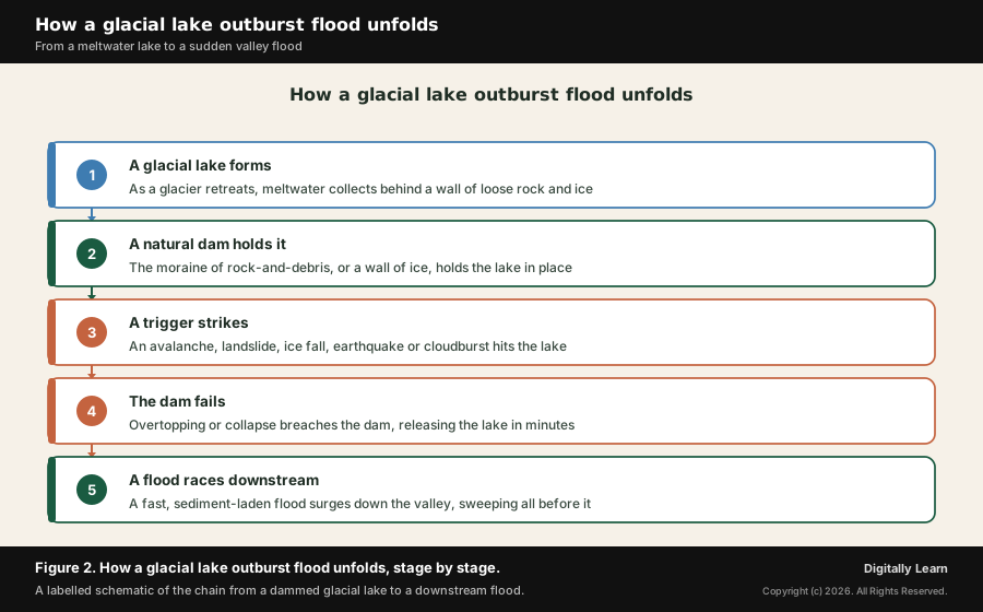
A GLOF is best understood as a chain of events. First, a glacier retreats and its meltwater gathers in a hollow, forming a lake held back by a moraine of rock and debris or by a wall of ice. Over years, as the glacier shrinks further, the lake grows larger and deeper, and the pressure on its fragile natural dam rises.
Then a trigger arrives: an avalanche or rockfall into the lake, a calving block of ice, an earthquake or a cloudburst. The disturbance either sends a wave over the dam or weakens it directly. Once the dam is overtopped or collapses, the breach widens fast, and the stored water escapes in a single, violent surge rather than a gradual outflow.
The escaping flood is not clear water but a sediment-laden torrent, picking up rock, boulders and debris as it tears down the steep valley. This bulked-up flow is what destroys bridges, roads and settlements kilometres downstream. The figure below traces the stages of this chain.
Climate change and the Third Pole driver
The deeper driver of rising GLOF risk is climate change. The Himalaya and the wider Hindu Kush Himalaya hold the largest body of ice outside the two poles, which is why the region is called the Third Pole and the water tower of Asia. As global temperatures rise, these glaciers are melting and retreating at an accelerating pace.
Retreating glaciers do two things that raise the danger. They release more meltwater, and they expose hollows that fill to form new glacial lakes while existing lakes expand. India's official assessments record glaciers in the Chandra basin retreating at roughly 13 to 33 metres a year and a steady growth in the number and area of glacial lakes across the high Himalaya.
More lakes, larger lakes and more meltwater together mean more potential GLOF sources and more energy behind any future flood. The hazard is therefore not static but growing with the warming climate, which is why monitoring and early warning have become so urgent for the Himalayan states.
The South Lhonak Event and the Urgent Early-Warning Response
The October 2023 Sikkim GLOF and its downstream impact
The clearest recent example is the South Lhonak Lake GLOF in North Sikkim. In the early hours of 4 October 2023, the lake burst through its moraine dam and emptied into the Teesta river system. Satellite analysis by India's National Remote Sensing Centre found that about 105 hectares of the lake's area had drained out within days, a measure of the sheer volume of water released.
The flood that followed was devastating. The Teesta rose sharply, by tens of feet in places, and the surge swept down the valley, washing away long stretches of National Highway 10, several bridges and the Chungthang dam of the Teesta-III hydropower project. Towns and army installations along the river suffered heavy damage, and there was a grievous loss of life, with many people swept away or left missing.
The disaster exposed how exposed the valley had become. A single GLOF, high in a remote glacial basin, cascaded into a downstream catastrophe for infrastructure and communities, precisely because dams, roads and settlements lay in the river's path. It became the reference point for India's GLOF policy.
The urgent push for early-warning systems
The South Lhonak disaster triggered an urgent response on early warning. The immediate lesson was that the high-risk lakes feeding India's mountain rivers were not adequately watched, and that a few minutes of warning could let people downstream move to safety before a surge arrives.
Agencies began installing Early Warning Systems and Automatic Weather Stations in the Himalayan states, with two automatic weather stations set up in Sikkim and further deployments planned. These systems are being developed in collaboration with technical partners, including C-DAC, ISRO and the Space Applications Centre in Ahmedabad, so that sensors and satellite monitoring can flag a dangerous lake before it fails.
Mitigation and Institutions: The NGRMP, NDMA and the CoDRR
The National GLOF Risk Mitigation Project and its measures
India's central response is the National GLOF Risk Mitigation Project, or NGRMP. The Central Government approved it for four Himalayan states, Arunachal Pradesh, Himachal Pradesh, Sikkim and Uttarakhand, at a financial outlay of about Rs 150 crore, of which roughly Rs 135 crore is the central share from the National Disaster Mitigation Fund and about Rs 15 crore is contributed by the states.
The project's aim is to prevent loss of life and reduce damage to critical infrastructure from GLOFs. It begins by building a scientific inventory of glacial lakes and identifying the high-risk ones using satellite analytics and expert validation, so that scarce effort is focused where the danger is greatest.
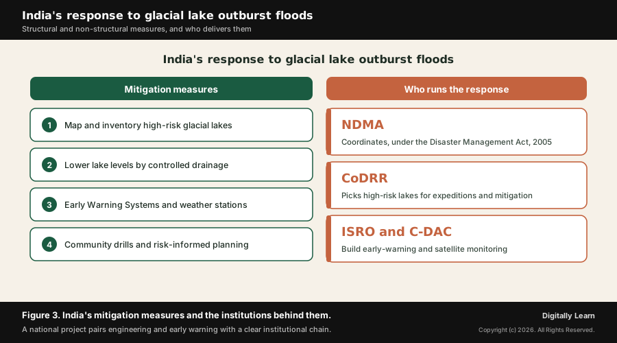
The measures it funds fall into two families. Structural measures physically reduce the danger, for instance by lowering a lake's level through controlled drainage so less water is stored behind the dam. Non-structural measures reduce harm without altering the lake, through Early Warning Systems, automatic weather stations, community drills and risk-informed land use. The figure below pairs the measures with the bodies that deliver them.
| Type of measure | What it does | Examples |
|---|---|---|
| Structural | Physically lowers the hazard at the lake | Lowering lake levels by controlled drainage, channel works |
| Non-structural | Reduces harm without altering the lake | Early warning systems, weather stations, community drills |
Read together, the two rows show the logic of mitigation: where engineering can safely reduce the water held behind a dam it is used, and everywhere else the emphasis falls on watching the lake and warning the people below in time.
Who runs the response: NDMA, the CoDRR and partners
The institutional spine of the response is the National Disaster Management Authority, the NDMA, which works under the Disaster Management Act, 2005 and coordinates disaster policy across ministries and states. The NDMA issued dedicated Guidelines for the Management of Glacial Lake Outburst Floods, with a standard operating procedure covering preparedness, real-time response and recovery.
To focus the effort, the NDMA set up a Committee on Disaster Risk Reduction, the CoDRR, with representatives from the Himalayan states and union territories. The committee identifies a set of high-risk glacial lakes and sends expeditions to assess them directly and design mitigation, whether early-warning systems or structural works, lake by lake.
The work draws in scientific and technical partners. The Central Water Commission has framed criteria to rank glacial lakes by risk, while ISRO, the National Remote Sensing Centre and the Space Applications Centre supply satellite monitoring, and C-DAC helps build the warning systems. Together this chain turns a national project into action on the ground.
Challenges, Development-versus-Ecology and the UPSC Context
The hard problems in managing GLOF risk
Managing GLOF risk is genuinely difficult, and a balanced view must weigh the challenges. The first is the sheer scale of monitoring: there are hundreds of glacial lakes high in remote, hard-to-reach terrain, with about 902 lakes larger than ten hectares now tracked by remote sensing, and watching every one in real time is a formidable task.
A second challenge is the cost and engineering of mitigation. Lowering a lake or installing equipment at extreme altitude is expensive, technically hard and slow, and the high mountains are seismically active and prone to landslides, which makes the structures themselves vulnerable. Data and forecasting limits add to the difficulty, since the exact moment a dam will fail is very hard to predict.
A further dimension is trans-boundary. Many Himalayan rivers and their glacial basins cross international borders, so a lake or a flood may originate beyond India's territory, which means effective warning and risk reduction often need cooperation with neighbouring countries.
The development-versus-ecology debate in the Himalaya
GLOFs sit at the centre of a wider development-versus-ecology debate in the mountains. The Himalaya is a young, rising and unstable range, yet it has seen rapid building of hydropower dams, highways and tourist towns, often in narrow valleys directly downstream of glacial lakes. This places more people and assets in harm's way.
Those who favour development point to the region's need for clean hydropower, road connectivity and tourism income, and to the livelihoods these support. They argue that careful siting and engineering can manage the risk rather than forgo the benefits altogether.
Those who urge caution stress the fragility of the range and the cascading nature of mountain disasters, as the Teesta valley showed, where a glacial flood and a hydropower dam compounded each other. The fair conclusion is that development in the Himalaya must be risk-informed: not halted, but guided by hazard mapping, honest environmental assessment and respect for the mountains' ecological limits.
The Cryosphere, the Disaster-Management Cycle and Mountain Development
Contemporary linkages tie GLOFs to several larger stories. They are part of the wider crisis of the cryosphere, the frozen part of the Earth, whose retreat under global warming also threatens water security for the great Himalayan rivers on which hundreds of millions depend.
They connect, too, to the disaster-management cycle of prevention, mitigation, preparedness and response, and to India's stated shift from a reactive, relief-centred approach towards proactive, technology-driven risk reduction. GLOF mitigation is a textbook case of that shift in practice.
Finally, they link to debates on sustainable mountain development, on the carrying capacity of fragile hill states, and on the role of space technology and remote sensing in watching hazards that no ground team could monitor alone.
UPSC Relevance and Exam Focus
This topic maps to General Studies Paper I: geography, important geophysical phenomena, and especially to General Studies Paper III: disaster and disaster management, with strong links to climate change and the protection of fragile ecosystems.
For Prelims, hold the high-yield facts: a GLOF is the sudden release of a glacial lake when its moraine or ice dam fails; the South Lhonak Lake GLOF struck Sikkim and the Teesta valley in October 2023; the National GLOF Risk Mitigation Project covers four states; and the NDMA works under the Disaster Management Act, 2005.
For Mains, the recurring framing is GLOFs as a climate-change-induced disaster and as a test of proactive disaster management, alongside the balance between development and ecological safety in the Himalaya. A strong answer treats the hazard, its driver and the State's response as a single connected argument.
Recurring linked concepts an aspirant should keep in working memory:
- Moraine-dammed lake: A glacial lake held by a wall of loose rock and debris, prone to sudden failure.
- The Third Pole: The Himalayan and Hindu Kush region, the largest store of ice outside the poles and the water tower of Asia.
- Disaster-management cycle: The sequence of prevention, mitigation, preparedness and response that frames modern disaster policy.
- Disaster Management Act, 2005: The law under which the NDMA coordinates India’s disaster response and risk reduction.
A common Prelims trap is to treat a GLOF as an ordinary flood. It is specifically the failure of a natural ice or moraine dam holding a glacial lake, not a rain-fed river flood, though a cloudburst can trigger it.
A common Mains trap is to describe the disaster without naming the response. The exam value lies in connecting the hazard and its climate driver to concrete measures, the NGRMP, early warning and the CoDRR, and to the proactive shift in India's disaster management.
Previous Year UPSC-CSE Questions By the end you will be able to draft model answers for the following UPSC questions. Each question carries a collapsible framework showing how to approach it in the exam.
- UPSC Mains 2020 GS-IIIDiscuss the recent measures initiated in disaster management by the Government of India departing from the earlier reactive approach.
How to structure the answer in the exam
Body (sub-themes to develop):
- The old approach was reactive: the State acted mainly after a disaster struck, focusing on rescue, relief and compensation rather than on reducing risk in advance.
- The proactive shift rests on the Disaster Management Act, 2005 and the NDMA, which place prevention, mitigation and preparedness ahead of response in the disaster-management cycle.
- Recent measures include the National GLOF Risk Mitigation Project for four Himalayan states, with structural works such as lowering lake levels and non-structural early-warning systems and weather stations.
- Risk is now assessed in advance: scientific inventories and satellite analytics identify high-risk glacial lakes, the CoDRR sends expeditions, and the Central Water Commission ranks lakes by risk.
- Technology and early warning are central: ISRO and remote sensing watch hazards, and warning systems built with C-DAC aim to give downstream communities time to move, departing from purely reactive relief.
Sources and Further Reading
- PIB: Glacial Lake Outburst Flood Mitigation
- PIB: GLOF Mitigation Project
- PIB: Impact of Glacial Lake Outburst Floods
- PIB: Committee on Disaster Risk Reduction (CoDRR)
- NDMA: National Disaster Management Authority, Government of India
- ISRO: Satellite image-based studies of South Lhonak Lake
- DST: River runoff, glacier melt and seasonality of flow in Himalayan rivers
- MoES: Strategy on glacier and climate protection (Parliament answer)
- Wikipedia: Glacial lake outburst flood
Editorial Disclaimer
This briefing is for UPSC preparation. Verify the figures and event details against the official NDMA, PIB and ISRO sources before relying on them.


