
Overview
Hazard mapping, the Himalayan gaps, and microzonation
How the BIS IS 1893 four-zone map encodes India's earthquake risk, which regions sit in the highest Zone V, where the Himalayan seismic gaps lie, and how microzonation refines hazard at city scale.
Previous Year UPSC-CSE Questions By the end you will be able to draft model answers for the following UPSC questions. Each question carries a collapsible framework showing how to approach it in the exam.
- UPSC Mains 2021 GS-IIIDiscuss about the vulnerability of India to earthquake related hazards. Give examples including the salient features of major disasters caused by earthquakes in different parts of India during the last three decades.
How to structure the answer in the exam
Introduction: India's earthquake vulnerability is driven by its position at the active leading edge of the Indian Plate's northward collision with the Eurasian Plate. The Himalayan thrust system is the country's primary seismic belt; intraplate stresses produce additional hazards in peninsular and Bhuj-Kachchh regions. Approximately 59 per cent of India's land area lies in BIS Zones III, IV, and V combined.
Body (sub-themes to develop):
- Himalayan-belt thrust events: 1991 Uttarkashi Mw 6.8, 1999 Chamoli Mw 6.8, 2005 Kashmir Mw 7.6 (~80,000 regional deaths), 2011 Sikkim Mw 6.9, 2015 Nepal Gorkha Mw 7.8 (India-Nepal border impact).
- Western intraplate Bhuj-Kachchh event: 2001 Bhuj Mw 7.7 killed approximately 20,000 people, destroyed over 400,000 houses, demonstrated stable-continental-region hazard, triggered creation of ISR Gandhinagar.
- Peninsular intraplate surprise: 1993 Latur Mw 6.2 killed approximately 9,800 people in a region not previously considered earthquake-prone; exposed the gap in disaster preparedness in 'safe' zones.
- Salient features as vulnerability markers: building-stock failure (Latur), large-scale fatality numbers (Bhuj, Kashmir), trans-border response coordination (Nepal), and the role of microzonation in differentiating actual risk within a single zone.
- Contemporary frame: NCS 161 stations 2024 and ISR Gandhinagar and Mission Mausam integration and Central Seismic Gap monitoring and city-level microzonation.
Conclusion: India's earthquake vulnerability is therefore not uniform but spatially segmented. The Himalayan belt carries Zone V hazard; Bhuj-Kachchh is a stable-continental-region anomaly; the peninsular shield contains rare but consequential intraplate sources. Recognising this diversity is the foundation for the NDMA disaster-management framework discussed in Part 3.
- UPSC Prelims 2008 General StudiesIn the year 2007, an earthquake led to massive radioactive water leakage in the largest nuclear plant in the world. In which country did it occur?
How to approach this Prelims question
Approach: The 2007 Niigata-Chuetsu-Oki earthquake (Mw 6.6) damaged the Kashiwazaki-Kariwa Nuclear Power Plant in Japan, the world's largest nuclear-power facility at the time. The correct answer is (c) Japan. The question tests awareness of earthquake-nuclear-safety intersection, relevant to India's Zone-III nuclear-plant siting decisions.
Trap to watch: Options (a) Germany and (d) USA both have nuclear plants but neither experienced a major earthquake in 2007 that damaged a nuclear facility. Option (b) Canada has nuclear plants but in seismically stable regions.
Key facts to recall:
- 2007 Niigata-Chuetsu-Oki earthquake: Mw 6.6, July 16, Japan; damaged Kashiwazaki-Kariwa nuclear plant.
- Kashiwazaki-Kariwa: world's largest nuclear power facility at the time (7 reactor units, ~8.2 GWe capacity).
- Indian nuclear plants and BIS zones: Kakrapar (Zone III), Tarapur (Zone III), Kudankulam (Zone II), Kalpakkam (Zone III), Narora (Zone IV).
- Atomic Energy Regulatory Board (AERB) issues design and operational criteria for Indian nuclear plants under IS 1893 plus additional safety margins.
Answer signal: (c) Japan
- UPSC Prelims 2001 General StudiesA great landslide caused by an earthquake killed hundreds of people in January 2001 near
How to approach this Prelims question
Approach: The January 13, 2001 El Salvador earthquake (Mw 7.7) triggered a major landslide at Santa Tecla near San Salvador, killing hundreds. The correct answer is (a) San Salvador. The earthquake also damaged areas in El Salvador, Guatemala, and Honduras. Note: this is two weeks BEFORE the unrelated 2001 Bhuj earthquake of January 26.
Trap to watch: Many candidates may confuse 2001 January with 2001 Bhuj (also January 2001). Bhuj was Mw 7.7 on January 26 in Gujarat, India; this PYQ is about a DIFFERENT event on January 13 in El Salvador. The PYQ options are all Central American capitals, ruling out any confusion with India.
Key facts to recall:
- January 13, 2001 El Salvador earthquake: Mw 7.7; triggered Santa Tecla landslide near San Salvador; approximately 600-700 deaths from the landslide alone.
- January 26, 2001 Bhuj earthquake: Mw 7.7; UNRELATED separate event; approximately 20,000 deaths in Gujarat, India.
- Earthquake-triggered landslides in India: 1991 Uttarkashi, 1999 Chamoli, 2005 Kashmir, 2011 Sikkim, 2015 Nepal events all produced cascading slope failures in the Himalaya.
- Hazard implication: landslide risk multiplies Himalayan-earthquake casualty figures; microzonation maps integrate landslide-susceptibility data.
Answer signal: (a) San Salvador
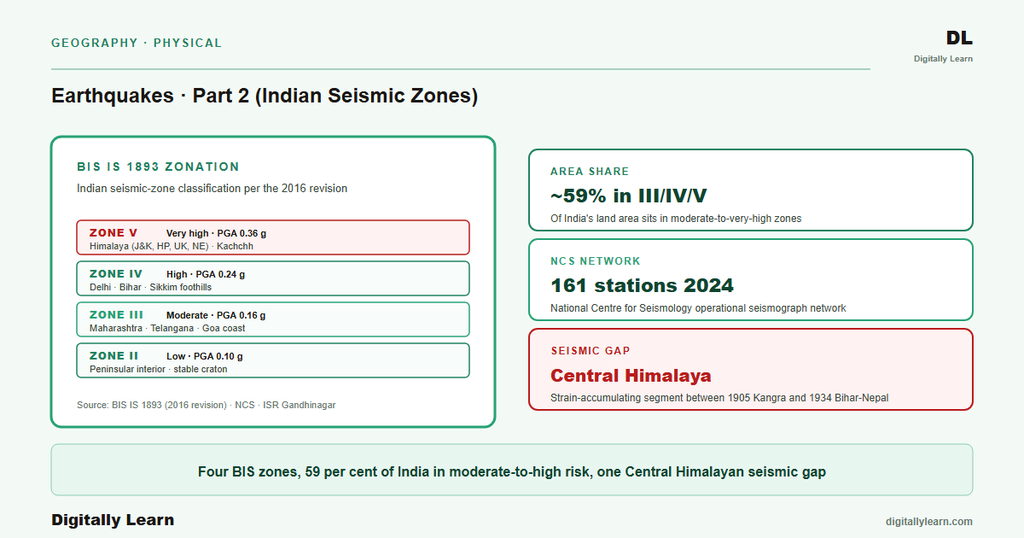
Indian seismic-zone mapping divides the country into four hazard categories under Bureau of Indian Standards code IS 1893. Zone II is low hazard, Zone III is moderate, Zone IV is high, and Zone V is the highest. The classification is based on peak ground acceleration (PGA) ranges expected during the 475-year return-period earthquake. Approximately 59 per cent of India's land area lies in Zones III, IV, and V combined. The Himalayan front, the Bhuj-Kachchh region of Gujarat, parts of the North-Eastern states, and the Andaman-Nicobar Islands sit in Zone V. Most of peninsular India lies in Zone III, with smaller pockets of Zone II in the deep interior.
Background and Historical Context
India sits at the active leading edge of the Indian Plate's collision with the Eurasian Plate. The collision drives the Himalayan thrust system and produces the country's primary seismic belt. Approximately 59 per cent of India's land area lies in moderate-to-high seismic hazard zones under Bureau of Indian Standards IS 1893. UPSC Prelims and Mains repeatedly anchor on BIS zone classification, the 2001 Bhuj earthquake, the 1993 Latur intraplate event, the Himalayan seismic gap, and the contemporary microzonation programmes for major Indian cities.
Indian seismicity has been documented since 1819, when the Kutch earthquake destroyed Bhuj and altered the lower Indus drainage. Modern instrumental seismology began with the establishment of the Calcutta observatory in 1898. The Bureau of Indian Standards first issued seismic-design code IS 1893 in 1962; the code has been revised six times, most recently in 2016. The Institute of Seismological Research (ISR) Gandhinagar was established after the 2001 Bhuj earthquake; the National Center for Seismology operates the dense modern instrumental network from Delhi.
Part 1 of this series covered the science foundation: plate tectonics, fault mechanics, seismic waves, and the magnitude-intensity measurement framework. Part 2 (the current part) maps that science onto India: the BIS IS 1893 zoning, the historical earthquake roster, the seismic-gap hypothesis, and city-level microzonation. Part 3 will close the cluster with the NDMA disaster-management framework, the Disaster Management Act 2005, India's implementation of the Sendai Framework, and the earthquake-resistant construction code family.
Bureau of Indian Standards IS 1893: Four-Zone Classification, Peak Ground Acceleration, and Revision History
Four-zone classification
Bureau of Indian Standards (BIS) IS 1893 is the foundational seismic-design code for India. The code divides the country into four hazard zones based on expected peak ground acceleration (PGA) during the 475-year return-period earthquake. The classification provides the design-load envelope every structural engineer in India must use when sizing reinforcement, bracing, and foundations.
- Zone II (Low hazard): PGA approximately 0.10 g; expected MSK intensity VI or lower in the design event. Covers interior peninsular India and parts of central Madhya Pradesh and Rajasthan.
- Zone III (Moderate hazard): PGA approximately 0.16 g; expected MSK intensity VII. Covers most of peninsular India, parts of Maharashtra and the southern plateau.
- Zone IV (High hazard): PGA approximately 0.24 g; expected MSK intensity VIII. Covers Delhi NCR, northern parts of the Indo-Gangetic plain, parts of Maharashtra (around Latur), and the foothill segments of the Himalayan belt.
- Zone V (Very high hazard): PGA approximately 0.36 g; expected MSK intensity IX or higher. Covers the North-Eastern states, the Bhuj-Kachchh region of Gujarat, parts of Uttarakhand-Himachal-Jammu, and the Andaman-Nicobar Islands.
Revision history of IS 1893
IS 1893 was first issued by the BIS in 1962. The code has been revised six times since: in 1966, 1970, 1984, 2002, and 2016. Each revision incorporates new historical-earthquake data and updated PGA estimates. The 2002 revision (Part 1) introduced the four-zone classification used today; the 2016 revision (Part 1) updated PGA values, refined site-class definitions, and added performance-based design provisions.
Earlier versions of IS 1893 used a five-zone system (Zones I through V) that was reduced to four zones in 2002 by merging the old Zone I into Zone II. The current four-zone map reflects this consolidation. The 2015 Nepal earthquake triggered fresh scientific debate on the adequacy of the present zoning along the central Himalayan belt; revision discussions are ongoing but no formal change has been issued.
State-wise Zone Allocation: Zone V Hotspots, Zone IV Corridor, and the Peninsular-Shield Distribution
State-wise zone allocation
What is the significance of state-wise zone allocation? The BIS zoning translates the abstract seismic-hazard map into actionable design constraints state by state and district by district. A municipal corporation in Delhi (Zone IV) must enforce a stricter ductile-detailing standard than one in Bangalore (Zone II). The state-wise allocation also drives state-level disaster management plans and the targeting of National Disaster Response Force pre-positioning.
Zone V (very high hazard) covers the entire North-Eastern region (Assam, Arunachal Pradesh, Nagaland, Manipur, Mizoram, Tripura, Meghalaya, Sikkim), the Bhuj-Kachchh region of Gujarat, parts of Uttarakhand (Garhwal-Kumaon Himalaya), parts of Himachal Pradesh, parts of Jammu and Kashmir-Ladakh, and the Andaman and Nicobar Islands. Zone IV (high hazard) covers Delhi NCR, north Bihar, Maharashtra (around Latur and Koyna), parts of Punjab and Haryana, and the trans-Himalayan foothills. Zone III (moderate hazard) covers most of peninsular India, including Mumbai, Chennai, Kolkata, Hyderabad, Bangalore (Bengaluru is straddling Zone II/III boundary), and large parts of Madhya Pradesh and Odisha. Zone II (low hazard) covers interior central India, parts of southern Karnataka, southern Tamil Nadu, and pockets of Rajasthan.
| City | State / UT | Zone | Expected PGA |
|---|---|---|---|
| Delhi | Delhi NCR | Zone IV | ~0.24 g |
| Mumbai | Maharashtra | Zone III | ~0.16 g |
| Kolkata | West Bengal | Zone III | ~0.16 g |
| Chennai | Tamil Nadu | Zone III | ~0.16 g |
| Bengaluru | Karnataka | Zone II | ~0.10 g |
| Hyderabad | Telangana | Zone II / III boundary | ~0.10-0.16 g |
| Guwahati | Assam | Zone V | ~0.36 g |
| Srinagar | J&K | Zone V | ~0.36 g |
| Bhuj | Gujarat | Zone V | ~0.36 g |
| Patna | Bihar | Zone IV | ~0.24 g |
| Dehradun | Uttarakhand | Zone IV | ~0.24 g |
| Shimla | Himachal Pradesh | Zone IV | ~0.24 g |
Indian Historical Earthquakes: Himalayan-Belt Events, Peninsular Intraplate Anomalies, and the Bhuj Edge Case
Distinguishing features of Indian historical earthquakes
Indian historical earthquakes fall into three distinguishing classes by tectonic setting. Each class produces a characteristic magnitude range, depth distribution, and recurrence interval.
- Himalayan-belt thrust events: Shallow earthquakes along the Main Himalayan Thrust system. Magnitudes range from moderate (around Mw 6) to great (around Mw 8.5). Recent examples include the 1934 Bihar-Nepal Mw 8.0, the 1950 Assam Mw 8.6, the 1991 Uttarkashi Mw 6.8, the 1999 Chamoli Mw 6.8, the 2005 Kashmir Mw 7.6, the 2011 Sikkim Mw 6.9, and the 2015 Nepal Gorkha Mw 7.8.
- Intraplate peninsular-shield events: Rare but consequential earthquakes in the stable continental region of peninsular India. The 1967 Koyna Mw 6.5 (reservoir-induced) and 1993 Latur Mw 6.2 events are the canonical Indian intraplate cases. Both occurred far from any active plate boundary; the Latur event was particularly damaging because the region was not previously considered earthquake-prone and the building stock had no seismic reinforcement.
- Intraplate Bhuj-Kachchh and Andaman-Nicobar events: The 2001 Bhuj Mw 7.7 was the largest stable-continental-region earthquake in India in recorded history. The 2004 Sumatra-Andaman Mw 9.1, although offshore Indonesia, produced significant Andaman-Nicobar damage and the Indian Ocean tsunami that killed approximately 230,000 people across multiple countries.
Historical earthquake roster
| Year | Event | Magnitude (Mw) | Casualties (approx.) | Current BIS Zone |
|---|---|---|---|---|
| 1819 | Kutch (Allah Bund) | ~7.8 | ~1,500 | Zone V |
| 1897 | Shillong | ~8.1 | ~1,500 | Zone V |
| 1905 | Kangra | ~7.8 | ~20,000 | Zone V |
| 1934 | Bihar-Nepal | ~8.0 | ~10,700 | Zone V |
| 1950 | Assam | ~8.6 | ~1,500 | Zone V |
| 1967 | Koyna (reservoir-induced) | ~6.5 | ~180 | Zone IV |
| 1991 | Uttarkashi | ~6.8 | ~770 | Zone IV/V |
| 1993 | Latur (intraplate) | ~6.2 | ~9,800 | Zone III/IV |
| 1999 | Chamoli | ~6.8 | ~100 | Zone V |
| 2001 | Bhuj | ~7.7 | ~20,000 | Zone V |
| 2004 | Sumatra-Andaman (offshore) | ~9.1 | ~230,000 (regional) | Zone V (A&N) |
| 2005 | Kashmir | ~7.6 | ~80,000 (regional) | Zone V |
| 2011 | Sikkim | ~6.9 | ~111 | Zone V |
| 2015 | Nepal (Gorkha) | ~7.8 | ~9,000 (regional) | Zone IV/V (border) |
The 2001 Bhuj earthquake of January 26 killed approximately 20,000 people and destroyed over 400,000 houses across Kachchh district and adjoining areas. Bhuj was classified as a stable-continental-region (intraplate) event by tectonic-setting analysis, but its location in Zone V reflects the recognised historical seismicity of the Kachchh-Saurashtra region. The Bhuj event triggered the creation of the Institute of Seismological Research at Gandhinagar and accelerated India's adoption of comprehensive earthquake-disaster management governance.
Seismic Gap Hypothesis: Observable Outcomes for Central Himalayan, Kashmir, and Assam-Myanmar Segments
Observable seismic-gap segments
The seismic-gap hypothesis applies the elastic-rebound theory (Part 1) to identifiable segments of a plate boundary. If strain is accumulating at a measured GPS rate and no large earthquake has ruptured the segment for many decades, the strain budget is approaching the threshold where rupture becomes increasingly probable. The hypothesis is statistical, not deterministic. It identifies most-probable future-earthquake locations, not exact dates.
- Central Seismic Gap (Uttarakhand-western Nepal segment): The Himalayan-arc segment between the 1905 Kangra and 1934 Bihar-Nepal rupture zones has not produced a great earthquake in instrumental times. GPS geodesy measures approximately 18 to 20 millimetres per year of convergence accumulating along this segment, implying a strain budget consistent with a future M8 or larger event. This is the most actively studied gap in the world.
- Kashmir Seismic Gap: The segment between the 1555 Kashmir earthquake and the 2005 Kashmir earthquake-rupture zone retains accumulated strain. Estimates suggest a sub-segment may rupture in a Mw 7 to 8 event.
- Assam-Myanmar Seismic Gap: The segment east of the 1950 Assam rupture along the Indo-Myanmar arc shows accumulated strain. Earthquakes in this region are deep and often intermediate-focus, complicating the gap analysis.
Hazard Mapping and Microzonation: City-Level Vulnerability Atlases, Soil Amplification, and PGA Contours
City-level microzonation programme
Seismic microzonation refines the BIS-zone classification at the city block scale by mapping local soil conditions, basement-rock depth, and site-amplification factors. The same PGA event produces very different ground motion on hard rock versus soft alluvium; microzonation captures this variation to inform building-by-building risk planning.
The Ministry of Earth Sciences and the Geological Survey of India coordinate the national microzonation programme. Completed microzonation studies include Delhi (under the Indian Institute of Technology Roorkee), Bangalore, Guwahati, Kolkata, Sikkim, and Chennai. Mumbai, Patna, Dehradun, Shillong, and Srinagar are under active study. The Indo-Gangetic plain receives particular attention because its thick alluvial fill produces strong site amplification and liquefaction risk during distant Himalayan earthquakes.
Soil amplification can multiply surface PGA by factors of 2 to 5 over the bedrock motion. Liquefaction occurs when saturated loose sand layers lose strength during strong shaking, behaving like a fluid. The Indo-Gangetic plain south of the Himalayan front carries both risks. The 1934 Bihar-Nepal earthquake produced widespread liquefaction across northern Bihar; modern microzonation maps these zones to guide development restrictions and foundation-design requirements.
Contemporary Linkages: NCS Operational Monitoring, ISR Gandhinagar Institutional Role, and Mission Mausam Integration
Contemporary linkages
India's seismic-hazard infrastructure rests on three institutional pillars in 2026. The National Center for Seismology (NCS Delhi) operates 161 seismic stations nationwide as of 2024 and issues real-time earthquake bulletins within 7 to 10 minutes of every M3.5 or larger event in or near India. Bulletins feed NDMA and state disaster authorities; the same data feeds the seismic-gap analysis and the central Himalayan strain-budget studies.
The Institute of Seismological Research (ISR) Gandhinagar in Gujarat operates a dense regional network covering western India. ISR was established by the Government of Gujarat after the 2001 Bhuj earthquake and coordinates with NCS on microzonation studies, instrumental records, and post-earthquake field response. GPS-geodesy networks, operated by institutions such as CSIR-NGRI and the Wadia Institute of Himalayan Geology, measure the steady strain accumulation along the Himalayan front that the seismic-gap analysis in Section 4 tracks.
Mission Mausam announced by the Ministry of Earth Sciences in September 2024 integrates atmospheric and seismic monitoring with a unified data pipeline. The integration supports compound climate-disaster risk assessment. For example, Himalayan earthquakes increasingly intersect with Glacial Lake Outburst Floods, monsoon-triggered landslides, and ENSO-modulated rainfall. The BhooKamp mobile app launched by MoES in 2021 delivers earthquake alerts to citizens; integration with the National Earthquake Early Warning System is under build-out. Part 3 of this series carries the seismic-hazard map established here into the NDMA disaster-management policy framework, the Disaster Management Act 2005, and the earthquake-resistant construction code family.
Prelims MCQ practice
Each question below tests one specific concept on the topic. Click to reveal the answer and a full option-wise explanation.
Q1. Consider the following statements about the Bureau of Indian Standards (BIS) seismic zoning of India under IS 1893:
- The code currently divides India into four seismic zones, numbered II to V, with Zone V being the highest-hazard zone.
- The four-zone system replaced an earlier five-zone system in 2002, when the lowest zone was merged into Zone II.
- Zone II represents the highest seismic hazard and covers the Himalayan belt.
Which of the statements given above is/are correct?
- 1 and 2 only
- 2 and 3 only
- 1 and 3 only
- 1, 2 and 3
Show answer and explanation
Answer: 1 and 2 only
Explanation.
Statements 1 and 2 are correct. IS 1893 uses four zones (II to V), with Zone V the highest hazard; the five-zone system was reduced to four in 2002 by merging the old Zone I into Zone II. Statement 3 is wrong: Zone II is the lowest-hazard zone (the stable interior peninsula), not the highest, and the Himalayan belt lies in Zones IV and V.
Q2. With reference to areas classified under BIS Seismic Zone V (very high hazard), consider the following:
- The entire North-Eastern region
- The Kachchh region of Gujarat
- The interior Deccan plateau
Which of the above lie largely in Zone V?
- 1 only
- 1 and 2 only
- 2 and 3 only
- 1, 2 and 3
Show answer and explanation
Answer: 1 and 2 only
Explanation.
1 and 2 only. The entire North-East and the Kachchh region of Gujarat fall in Zone V. The interior Deccan plateau is part of the stable peninsular shield and lies mostly in the lowest-hazard Zone II.
Q3. Consider the following statements about the 2001 Bhuj earthquake:
- It struck the Kachchh region, which lies in seismic Zone V.
- It is best described as an intraplate earthquake, away from a plate boundary.
- It occurred along the Main Himalayan Thrust.
Which of the statements given above is/are correct?
- 1 only
- 1 and 2 only
- 2 and 3 only
- 1, 2 and 3
Show answer and explanation
Answer: 1 and 2 only
Explanation.
1 and 2 only. The 2001 Bhuj earthquake struck Kachchh (Zone V) and killed about 20,000 people; it is a classic intraplate earthquake within the peninsular shield, not on a plate boundary. Statement 3 is wrong: it was not a Himalayan-thrust event.
Q4. With reference to the seismic-gap hypothesis as applied to the Himalaya, consider the following statements:
- A seismic gap is a segment of a plate boundary that has not ruptured in a great earthquake for a long time and is accumulating strain.
- The Central Seismic Gap lies between the rupture zones of the 1905 Kangra and 1934 Bihar-Nepal earthquakes.
- The hypothesis is an application of the elastic-rebound theory.
Which of the statements given above is/are correct?
- 1 and 2 only
- 2 and 3 only
- 1 and 3 only
- 1, 2 and 3
Show answer and explanation
Answer: 1, 2 and 3
Explanation.
All three are correct. A seismic gap is an un-ruptured, strain-accumulating boundary segment; the Central Seismic Gap sits between the 1905 Kangra and 1934 Bihar-Nepal ruptures; and the hypothesis applies elastic-rebound theory to flag overdue segments.
Q5. Consider the following statements about seismic microzonation and soil amplification:
- Microzonation refines the BIS zone classification at the scale of a city or block.
- Soft soils can amplify surface ground acceleration several times relative to the underlying bedrock motion.
- Liquefaction occurs mainly in dry, compacted rock.
Which of the statements given above is/are correct?
- 1 only
- 1 and 2 only
- 2 and 3 only
- 1, 2 and 3
Show answer and explanation
Answer: 1 and 2 only
Explanation.
1 and 2 only. Microzonation maps local soil and site response at block scale, and soft soils can amplify surface PGA roughly two to five times. Statement 3 is wrong: liquefaction occurs in saturated, loose sediments, not dry compacted rock, where shaking causes a temporary loss of strength.
Q6. Consider the following statements about India's seismic-monitoring institutions:
- The National Center for Seismology (NCS) operates under the Ministry of Earth Sciences.
- The Institute of Seismological Research (ISR) is located in Gujarat.
- Mission Mausam integrates atmospheric and seismic monitoring.
Which of the statements given above is/are correct?
- 1 and 2 only
- 2 and 3 only
- 1 and 3 only
- 1, 2 and 3
Show answer and explanation
Answer: 1, 2 and 3
Explanation.
All three are correct. The NCS is the nodal earthquake-monitoring agency under the Ministry of Earth Sciences; the ISR is located at Gandhinagar, Gujarat; and Mission Mausam (announced 2024) integrates atmospheric and seismic monitoring under a unified MoES data framework.
Sources and references
- National Center for Seismology, Ministry of Earth Sciences
- Ministry of Earth Sciences
- National Disaster Management Authority: earthquake risk
- Bureau of Indian Standards: IS 1893 earthquake-resistant design
- Geological Survey of India: seismotectonic atlas
- Press Information Bureau: BhooKamp app launch 2021
- Wikipedia: 2001 Bhuj earthquake
- Wikipedia: 1993 Latur earthquake
- Wikipedia: 1934 Nepal-Bihar earthquake
- Wikipedia: 2005 Kashmir earthquake
- Wikipedia: 2011 Sikkim earthquake
- Wikipedia: 2015 Nepal earthquake (Gorkha)
- Wikipedia: 2001 El Salvador earthquakes
- Wikipedia: 2007 Niigata-Chuetsu-Oki earthquake (Kashiwazaki-Kariwa nuclear plant)
- Wikipedia: Seismic zoning of India / BIS IS 1893
Disclaimer and notes
This article is compiled from the reference materials listed in the Sources section. It is an explainer for UPSC preparation and is not a substitute for primary documents (NCERTs, GoI ministry releases, IMD bulletins, RBI / CEA / MoEFCC publications, and Standing-Committee reports).


