


Overview
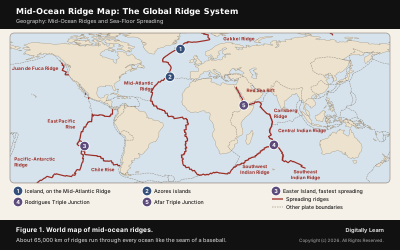
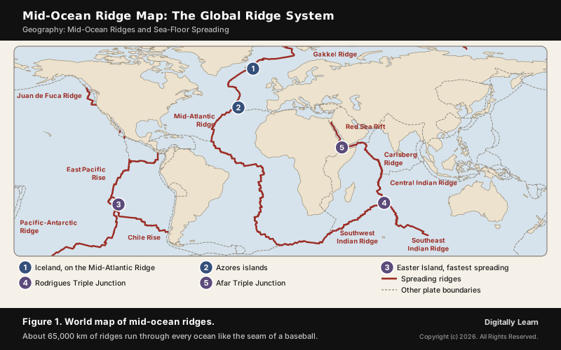
A mid-ocean ridge is an undersea mountain chain that forms where two tectonic plates move apart. Molten rock rises between the separating plates and erupts as basalt, creating new ocean floor, so a ridge is the place where sea-floor spreading happens. Joined together, the ridges form a continuous chain about 65,000 km long that runs through every ocean, the longest mountain range on Earth, with more than 90 per cent of it under water.
Mid-Ocean Ridge: Meaning, Length and Global Map
What Is a Mid-Ocean Ridge?
A mid-ocean ridge is a mountain system on the sea floor, formed by plate tectonics at a divergent plate boundary, where two plates move away from each other. It is an interconnected chain of mountains within the ocean and the longest mountain chain on the surface of the Earth, though it is submerged under the oceanic waters.
The numbers show why it is often called the longest relief feature in the world. The continuous chain runs for nearly 65,000 km, with more than 90 per cent of it in the deep ocean and an average depth of 2,500 m to the top of the ridge. The ridge rises about 2,000 m above the deepest part of an ocean basin, and the whole oceanic ridge system is about 80,000 km long.
- Plate boundary: A divergent, or constructive, boundary where new crust is created as plates pull apart.
- Rock: The new crust is basalt, erupted as lava from magma rising beneath the crest.
- Earthquakes: Frequent but shallow: quake foci under the ridges lie at shallow depths, unlike the deep-seated earthquakes of ocean trenches.
- Name: The first ridge found, the Mid-Atlantic Ridge, runs down the middle of its ocean; most other spreading centres do not, but are still called mid-ocean ridges.
Mid-Ocean Ridge Map: Where the Ridges Run
Most mid-ocean ridges are connected, and traced across the ocean floor they look like the seam of a baseball. The Mid-Atlantic Ridge runs down the Atlantic from the Arctic to the far South Atlantic, then turns east round Africa into the Indian Ocean, where the system branches. In the Pacific the chain continues as the East Pacific Rise and the Pacific-Antarctic Ridge.
Earthquakes trace the same pattern. A line of earthquake points runs through the middle of the Atlantic, almost parallel to the coastlines, and extends into the Indian Ocean, where it bifurcates a little south of India, one branch moving into East Africa and the other meeting a similar line from Myanmar to New Guinea. That line of dots coincides with the mid-oceanic ridges.
Structure of a Mid-Oceanic Ridge: Rift Valley, Plateau and Flank Zone
Parts of a Mid-Oceanic Ridge: Central Rift, Fractionated Plateau and Flank Zone
A mid-oceanic ridge has a central rift system at the crest, a fractionated plateau and a flank zone all along its length. The rift at the crest is the zone of intense volcanic activity, and its eruptions are known as mid-oceanic volcanoes. Seen in profile, the ridge is two chains of mountains separated by a large depression, with peaks as high as 2,500 m, some of which reach above the ocean's surface, as in Iceland.
- Central rift valley: The depression along the crest where the two plates separate and magma reaches the sea floor. Within it a zone only 1 to 2 km wide, the neovolcanic zone, holds the active volcanism.
- Fractionated plateau: The raised ground on either side of the central rift, between the rift and the flank zone.
- Flank zone: The long slopes on either side that descend towards the abyssal plains; the farther from the crest, the older and deeper the sea floor.
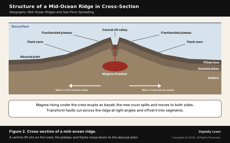
The mid-ocean ridge diagram in Figure 2 shows these parts in cross-section. The flanks slope down because the rock cools as it moves away. Close to the axis, hot, light mantle holds the crust up; as the plate cools it becomes thicker and denser, so older sea floor sits deeper. The depth of the sea floor is roughly proportional to the square root of its age, a balance explained by Pratt isostasy.
Transform Faults and Fracture Zones Across the Ridge
A ridge is not one straight line. It is broken into segments by transform faults, planes of separation that run generally perpendicular to the mid-oceanic ridges. Along a transform fault the plates slide past each other horizontally, so crust is neither produced nor destroyed; that is why transform boundaries are also called conservative boundaries.
- Why they form: Eruptions do not take place all along the crest at the same time, so parts of a plate move away at different rates; the rotation of the Earth also affects the separated blocks.
- Who named them: The Canadian geophysicist J. Tuzo Wilson recognised transform faults as a new class of fault; slip along one does not increase the distance between the ridge segments it joins.
- Fracture zones: Beyond the active part, the inactive scars of transform faults run across the ridge flanks as fracture zones.
- On land: A few transform faults cross continents, such as the San Andreas Fault in California.
One offset is dramatic enough to know by name. Near the equator the Romanche Trench, reaching 7,758 m, divides the Mid-Atlantic Ridge into the North Atlantic Ridge and the South Atlantic Ridge and is one of the deepest places in the Atlantic.
Oceanic Crust Made at the Ridge: Basalt, Pillow Lava and Gabbro
Every piece of ocean floor was once made at a ridge. Magma of basalt composition forms under the axis by decompression melting: mantle rock rising beneath the separating plates melts as the pressure on it falls. It cools into a new crust of basalt known as MORB, mid-ocean ridge basalt, with gabbro below it in the lower crust.
| Layer of oceanic crust | What it is |
|---|---|
| Pillow lava | Rounded lava bodies, commonly up to a metre across, formed when lava erupts under water |
| Sheeted dikes | Sheets of rock that carried magma up to feed the lava above |
| Gabbro | The lower oceanic crust, below the dikes |
Oceanic crust is thin, generally less than 10 km thick, but denser than continental crust. Slices of it are sometimes pushed up onto land as ophiolites: sections of oceanic crust and upper mantle exposed on a continent, such as Troodos in Cyprus and Semail in Oman. Ophiolites also occur in the Himalaya, including western Ladakh.
How a Mid-Ocean Ridge Forms: Sea-Floor Spreading
Mid-Ocean Ridge Formation: From Rising Magma to New Sea Floor
A mid-ocean ridge is formed when two plates pull apart and hot mantle rises into the gap. The process can be followed in five steps:
- Plates separate: Two oceanic plates move apart at a divergent boundary.
- Mantle rises and melts: Mantle rock wells up beneath the gap and partly melts as the pressure falls.
- Magma erupts: Magma rises through the weak zone between the plates and erupts on the sea floor as basalt lava.
- New crust forms: The lava cools into new oceanic crust, which is youngest along the axis.
- Crust moves away: The new crust is carried away on both sides, cooling, thickening and sinking, while fresh magma fills the gap.
What pulls the plates apart is still debated. Two forces are thought to drive spreading: ridge push, the gravitational sliding of the plate off the raised, hot ridge, and slab pull, the weight of the plate sinking at a subduction zone dragging the rest behind it. Slab pull is considered to contribute more. The older explanation, first proposed by Arthur Holmes in the 1930s, is slow convection currents in the hot, softened mantle below the rigid plates.
Sea-Floor Spreading Theory: Harry Hess and the Evidence
The sea-floor spreading theory was given by Harry Hess of Princeton University, who proposed it in 1960 and published it in his History of Ocean Basins in 1962; Robert Dietz introduced the term spreading of the seafloor in 1961. NCERT gives 1961 as the date of Hess's hypothesis. Hess argued that constant eruptions at the crest of the ridges rupture the oceanic crust, new lava wedges into it and pushes the older crust to either side, so the ocean floor spreads.
Hess's idea rested on facts that Wegener did not have. Five of them came from mapping the ocean floor and studying the magnetism of its rocks:
- Volcanic ridges: Eruptions are common all along the mid-oceanic ridges and bring huge amounts of lava to the surface.
- Symmetric rocks: Rocks equidistant on either side of the crest are remarkably similar in age, chemistry and magnetism; rocks closest to the crest are the youngest and have normal polarity.
- Young ocean floor: No oceanic crust is more than 200 million years old, while some continental rocks are 3,200 million years old.
- Thin sediments: Ocean-floor sediments are unexpectedly thin, and none is older than 200 million years.
- Shallow and deep earthquakes: Quakes are shallow at the ridges and deep-seated at the trenches.
Since one ocean could spread without another shrinking, Hess also asked where the crust goes. His answer was that the ocean floor pushed away from the crest sinks at the oceanic trenches and is consumed. Sea-floor spreading then fed directly into the theory of plate tectonics and continental drift, set out in 1967.
Magnetic Stripes and Geomagnetic Reversals: The Proof
The strongest evidence for sea-floor spreading is written in the rock. Basalt contains magnetite, a strongly magnetic mineral. When lava cools, its magnetite grains line up with the Earth's magnetic field and are locked in, recording the field's direction, normal or reversed, at that moment.
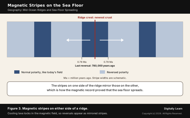
From the 1950s, magnetometers towed across the oceans found a zebra-like pattern: alternating stripes of normal and reversed polarity laid out in rows on either side of the ridge, the stripes on one side the mirror image of those on the other. In 1963 Frederick Vine and Drummond Matthews, and independently Lawrence Morley, explained the pattern: as new crust forms and spreads, it records every reversal of the Earth's field, so the ridge crest acts like a twin-headed tape recorder.
- How often the field flips: At least 183 reversals in the last 83 million years, on average about once every 450,000 years.
- The latest reversal: The Brunhes-Matuyama reversal, 780,000 years ago.
- Measuring spreading: Dating a stripe and measuring its distance from the crest gives the spreading rate, which is how plate speeds are calculated.
Spreading Rates: Slow, Fast and Ultraslow Ridges
Ridges spread at very different speeds, and speed decides their shape. Slower spreading gives steep, irregular topography, while faster spreading gives much wider profiles and gentler slopes. Slow ridges generally have large rift valleys, sometimes 10 to 20 km wide, with rugged relief of up to 1,000 m; fast ridges have none.
| Type of ridge | Spreading rate | Example and shape |
|---|---|---|
| Ultraslow | Under 2 cm a year | Gakkel Ridge, Southwest Indian Ridge; long stretches with no volcanism |
| Slow | Under 4 cm a year | Mid-Atlantic Ridge; deep rift valley |
| Intermediate | 4 to 9 cm a year | Southeast Indian Ridge |
| Fast | Over 9 cm a year | East Pacific Rise; smooth crest, no rift valley |
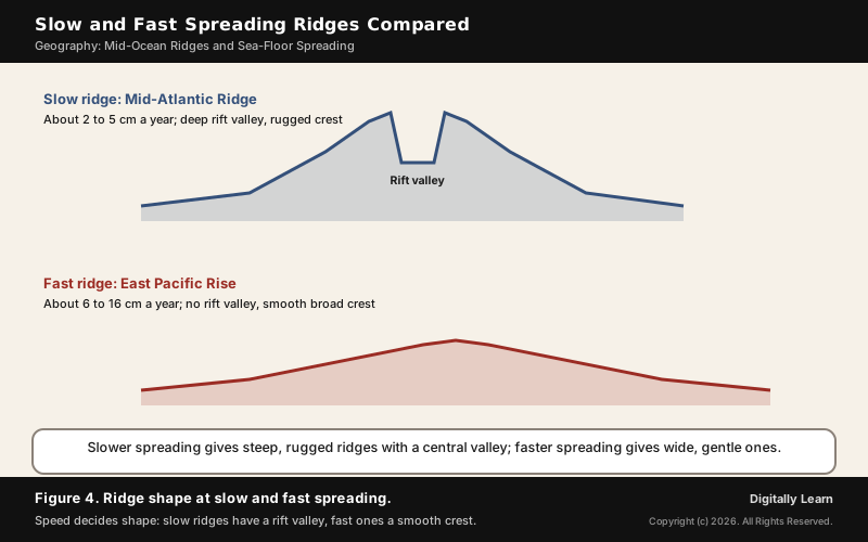
Two extremes are worth remembering: the Arctic Ridge spreads slowest, at less than 2.5 cm a year, and the East Pacific Rise near Easter Island, about 3,400 km west of Chile, spreads fastest, at more than 15 cm a year. The fastest rate ever known, over 20 cm a year, was on the East Pacific Rise in the Miocene.
Major Mid-Ocean Ridges of the World: Examples
Mid-Atlantic Ridge and Iceland: The Ridge Above Sea Level
The Mid-Atlantic Ridge is the best-known divergent boundary. It runs from a junction with the Gakkel Ridge north-east of Greenland south to the Bouvet triple junction in the South Atlantic. In the North Atlantic it separates the North American plate from the Eurasian and African plates; in the South Atlantic it separates the African and South American plates. It spreads at about 2.5 cm a year, and its rift valley is about the depth and width of the Grand Canyon.
- Discovery: First inferred by Matthew Fontaine Maury in 1853, confirmed by HMS Challenger in 1872 and by sonar in 1925.
- Mapping: In the 1950s Marie Tharp and Bruce Heezen produced the first scientific map of the Atlantic floor, which showed the ridge’s central valley.
- Islands on or near the ridge: Jan Mayen, Iceland, the Azores, Ascension Island, Saint Helena, Tristan da Cunha and Bouvet Island.
- A growing ocean: Spreading over the past 100 to 200 million years has turned the Atlantic from a narrow inlet into the ocean it is today.
Iceland is where the Mid-Atlantic Ridge can be walked on. The ridge runs through the island, which is splitting along the spreading centre as North America moves west relative to Eurasia. At Thingvellir a rift valley marks the crest of the ridge and the boundary between the two plates. Around Krafla Volcano, rifting episodes between 1975 and 1984 opened the ground by about 7 m. Iceland stands above the sea because it also sits over a hotspot, the Iceland plume, which is believed to have formed the island.
East Pacific Rise: The Fastest-Spreading Ridge
The East Pacific Rise is a mid-ocean ridge on the floor of the Pacific that runs south from the Gulf of California to about 55° S, where it joins the Pacific-Antarctic Ridge. It is called a rise rather than a ridge because its high spreading rate gives it gentler relief. It separates the Pacific plate to the west from the North American, Rivera, Cocos, Nazca and Antarctic plates.
- Speed: Over 15 cm a year near Easter Island, the fastest in the world, but only about 6 cm a year at its northern end, a range of 6 to 16 cm a year.
- No rift valley: Fast spreading leaves only a smooth volcanic summit with a small crack along the crest.
- Link to the Andes: On its eastern side the Cocos and Nazca plates move east and are subducted under the Americas, which is why volcanoes line the Andes and Central America.
- Black smokers: The hydrothermal vents called black smokers were first discovered on the East Pacific Rise in 1979.
Indian Ocean Ridges: Carlsberg, Central, Southwest and Southeast Indian Ridges
The Indian Ocean ridges branch, and their three arms meet at the Rodrigues Triple Junction, where the African, Indo-Australian and Antarctic plates meet. All three boundaries there are spreading ridges, so it is a ridge-ridge-ridge junction.
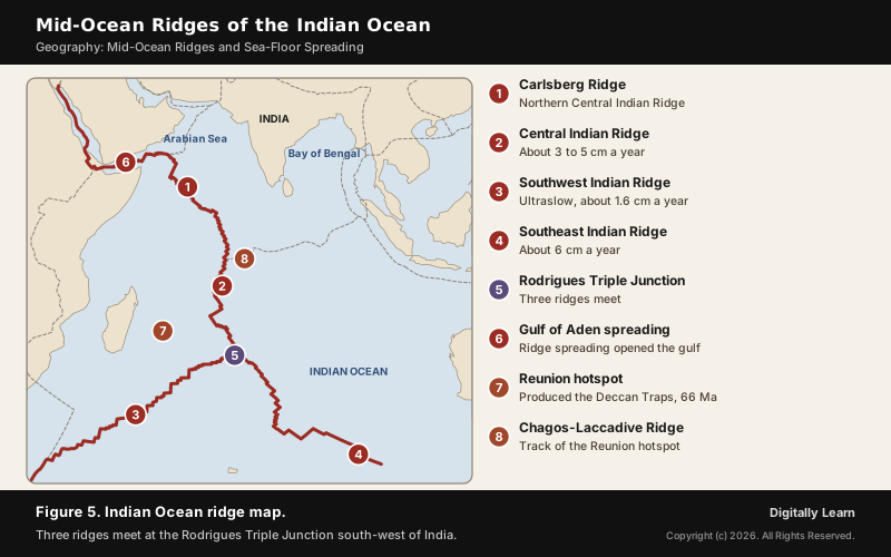
- Central Indian Ridge and Carlsberg Ridge: The Central Indian Ridge runs north through the western Indian Ocean between the African and Indo-Australian plates, spreading at about 3 cm a year near the equator and 5 cm near the triple junction. Its northern section, the Carlsberg Ridge, was found by the Danish Dana expedition of 1928 to 1930; its westward growth opened the Gulf of Aden.
- Southwest Indian Ridge: Between the Somali and Antarctic plates; one of the slowest ridges on Earth, about 1.6 cm a year at the triple junction, with 100 km stretches that have no volcanic activity.
- Southeast Indian Ridge: Almost 6,000 km long, between the Australian and Antarctic plates, spreading at about 6 to 7.5 cm a year.
These ridges carry India's own story. The western margin of the Indian plate follows the Kirthar Mountains and the Makran coast to the spreading site running from the Red Sea rift south-eastward along the Chagos Archipelago, and an oceanic ridge separates India from the Antarctic plate. India began its northward journey about 200 million years ago when Pangaea broke up; palaeomagnetic study of rocks from the Nagpur area traces its position, and it collided with Asia about 40 to 50 million years ago.
Mid-Ocean Ridges, Mantle Plumes and Changing Ocean Basins
Mantle Plumes and Hotspots at Ridges: Iceland and Réunion
A mantle plume is a proposed column of super-heated material that forms at the core-mantle boundary and rises through the mantle, first proposed by Jason Morgan in 1971 and 1972. When its head nears the surface it partly melts and feeds a hotspot. Plumes are invoked to explain hotspots such as Hawaii and Iceland and huge floods of basalt called large igneous provinces, such as the Deccan Traps.
- Tracking plate motion: A plume is thought to stay fixed while the plate moves over it, leaving a chain of volcanoes that gets older away from the hotspot, such as the Hawaiian-Emperor seamount chain.
- Iceland: The Iceland plume adds magma to the Mid-Atlantic Ridge, which is why Iceland stands above the sea while the rest of the ridge is mostly submerged. Some scientists think it helped rift Pangaea and open the North Atlantic.
- Réunion and India: The newborn Réunion hotspot produced the Deccan Traps in north-west India about 66 million years ago; its track includes the Chagos-Laccadive Ridge, and it later interacted with the Central Indian Ridge.
- Speeding up India: One suggestion, made in 2007, is that the plume that broke up Gondwana also melted the lower part of the Indian plate, letting it move faster and farther; its remains are thought to form the Marion, Kerguelen and Réunion hotspots.
How Ridges Change the Shape and Size of Oceans and Continents
Because ridges add crust and trenches remove it, ocean basins are always changing size. The Earth's size has not changed significantly for at least 600 million years, so crust must be destroyed at about the same rate as it is made. Hess saw the result: the Atlantic Ocean is widening while the Pacific Ocean is shrinking, as its floor sinks into the trenches of the Ring of Fire.
- Birth of an ocean: Spreading usually starts as a rift in a continent. The Red Sea and East Africa show this now: spreading has already torn Arabia from Africa to form the Red Sea, which is opening at about 1 cm a year on each side.
- A triple junction: At the Afar Triple Junction the Red Sea Rift, the Aden Ridge and the East African Rift meet. If spreading continues, the Indian Ocean may flood the area and make the Horn of Africa a large island.
- Young to old oceans: The Red Sea shows an ocean being born, the Atlantic a widening ocean, and the Pacific an ocean closing at its trenches.
- Oceans that closed: The Tethys Sea separated India from Asia until about 225 million years ago; India then moved north and collided with Asia about 40 to 50 million years ago and raised the Himalaya.
- Sea level: Faster spreading builds broader, shallower ridges that take up more space in the ocean basins, which has raised global sea level over millions of years.
Hydrothermal Vents, Seabed Minerals and India at the Ridges
Black Smokers and Chemosynthetic Life at Mid-Ocean Ridges
Mid-ocean ridge volcanoes heat the sea water around them, and hydrothermal vents are a common feature of spreading centres. Water from below the crust, heated to temperatures that can exceed 400 °C and rich in dissolved minerals, bursts through the ocean floor. The best-known vents are black smokers, named for the dark, sulphide-rich particles they emit.
- Where they are: Most often 2,500 to 3,000 m deep, in fields hundreds of metres wide.
- What they build: Sulphides of copper, iron and zinc settle in the chimneys, and over time the metal sulphides can become massive sulphide ore deposits.
- Polymetallic sulphides: These deposits contain iron, copper, zinc, silver, gold and platinum, and are precipitated from hot fluids of magma rising from deep in the oceanic crust and discharged through mineralised chimneys.
- Life without sunlight: Bacteria and archaea around the vents make food by chemosynthesis, using chemicals in the vent fluid, and support giant tube worms, clams, limpets and shrimp.
Polymetallic Sulphides and India's Seabed Exploration Contracts
Minerals on the deep seabed beyond national waters are managed by the International Seabed Authority (ISA), based in Kingston, Jamaica. It was set up under the 1982 UN Convention on the Law of the Sea and its 1994 Implementation Agreement, and it grants contracts to explore areas of the deep seabed for minerals such as cobalt, nickel and manganese.
- India’s first sulphide contract: A 15-year contract signed on 26 September 2016 for 10,000 sq km along the Central Indian Ridge and Southwest Indian Ridge. China, Korea and Germany were also active in the Indian Ocean at the time.
- India’s second sulphide contract: A 15-year contract announced in September 2025 for 10,000 sq km of the Carlsberg Ridge, making India the first country to hold two sulphide exploration contracts with the ISA and the holder of the largest sulphide exploration area on the international seabed.
- Nodules first: India was the first country to receive an area for polymetallic nodule exploration in international waters and was designated a Pioneer Investor.
- Deep Ocean Mission: The Ministry of Earth Sciences links the new contract to the Deep Ocean Mission, which focuses on seabed mineral exploration, mining technology and the Blue Economy.
- No mining yet: The ISA has not authorised any commercial mining contract while it deliberates over regulations amid calls for a moratorium.
Previous Year UPSC-CSE Questions
Previous Year UPSC-CSE Questions By the end you will be able to draft model answers for the following UPSC questions. Each question carries a collapsible framework showing how to approach it in the exam.
- UPSC Mains 2025 GS-IDiscuss how the changes in shape and sizes of continents and ocean basins of the planet take place due to tectonic movements of the crustal masses.
How to structure the answer in the exam
Introduction: Open with plate tectonics: crust is made at mid-ocean ridges and destroyed at trenches, so continents and ocean basins keep changing shape.
Body (sub-themes to develop):
- Divergence: sea-floor spreading at ridges widens oceans; the Atlantic has grown from a narrow inlet.
- Continental rifting: the Red Sea and the East African Rift show a new ocean forming at the Afar Triple Junction.
- Convergence: subduction at trenches shrinks the Pacific; the Tethys closed as India moved north.
- Collision: India met Asia 40 to 50 million years ago and the Himalaya rose; transform faults offset ridges without changing size.
- Evidence: magnetic stripes, the young age of the ocean floor and palaeomagnetic tracks of India.
Conclusion: Conclude that the continents and oceans are temporary arrangements of moving plates, still changing today.
- UPSC Mains 2018 GS-IDefine mantle plume and explain its role in plate tectonics.
How to structure the answer in the exam
Introduction: Define a mantle plume as a column of hot material rising from the core-mantle boundary, first proposed by Jason Morgan in 1971.
Body (sub-themes to develop):
- Hotspots: the plume head melts and feeds volcanism such as Hawaii and Iceland.
- Plate motion: a fixed plume under a moving plate leaves a chain of volcanoes that age away from it.
- Flood basalts: the Réunion plume produced the Deccan Traps about 66 million years ago.
- Rifting: plumes may help split continents, as the Iceland plume may have done in the North Atlantic.
Conclusion: Conclude that plumes both mark and may help drive plate motion, though their depth and role are still debated.
- UPSC Prelims 2021 Prelims-GSConsider the following statements:
- The Global Ocean Commission grants licences for seabed exploration and mining in international waters.
- India has received licences for seabed mineral exploration in international waters.
- ‘Rare earth minerals’ are present on seafloor in international waters.
Which of the statements given above are correct?
How to approach this Prelims question
Approach: Name the body that actually grants seabed licences, then check India's contracts.
Trap to watch: The Global Ocean Commission is not a licensing body; the ISA is.
Key facts to recall:
- The ISA, set up under UNCLOS, grants exploration contracts
- India holds ISA contracts for nodules and for polymetallic sulphides on the Indian Ocean ridges
Answer signal: Statements 2 and 3, option (b).
- UPSC Prelims 1995 Prelims-GSThe palaeomagnetic results obtained from India indicate that in the past, the Indian land mass has moved
How to approach this Prelims question
Approach: Recall where India lay before it met Asia.
Trap to watch: India was far south, near 50 degrees south, not east or west of its present position.
Key facts to recall:
- India began moving north about 200 million years ago
- It collided with Asia 40 to 50 million years ago
Answer signal: Northward, option (a).
Sources
- NCERT: Fundamentals of Physical Geography (Class XI), Distribution of Oceans and Continents; Water (Oceans)
- NOAA Ocean Exploration: What is a mid-ocean ridge?
- USGS: This Dynamic Earth, Developing the theory
- USGS: This Dynamic Earth, Understanding plate motions
- PIB (Ministry of Earth Sciences): India secures exclusive rights for polymetallic sulphides in the Carlsberg Ridge, 2025
- PIB (Ministry of Earth Sciences): India signs contract for exploration of polymetallic sulphides with ISA, 2016
- Wikipedia: Mid-ocean ridge
- Wikipedia: Mid-Atlantic Ridge
- Wikipedia: Seafloor spreading
- Wikipedia: East Pacific Rise
- Wikipedia: Carlsberg Ridge
- Wikipedia: Central Indian Ridge
- Wikipedia: Southwest Indian Ridge
- Wikipedia: Southeast Indian Ridge
- Wikipedia: Rodrigues Triple Junction
- Wikipedia: Transform fault
- Wikipedia: Vine–Matthews–Morley hypothesis
- Wikipedia: Geomagnetic reversal
- Wikipedia: Harry Hammond Hess
- Wikipedia: Marie Tharp
- Wikipedia: Mantle plume
- Wikipedia: Iceland hotspot
- Wikipedia: Geology of Iceland
- Wikipedia: Thingvellir
- Wikipedia: Red Sea Rift
- Wikipedia: Afar Triple Junction
- Wikipedia: Hydrothermal vent
- Wikipedia: Ophiolite
- Wikipedia: Pillow lava
- Wikipedia: Oceanic crust
- Wikipedia: Indian Plate
- Wikipedia: International Seabed Authority
- UPSC: Civil Services Examination question papers
Editorial Disclaimer
This article draws on the NCERT Class XI geography textbook, NOAA, USGS, the International Seabed Authority and the other sources listed on this page. Spreading rates are averages and vary along each ridge.


