


Overview
Ten biogeographic zones of India
Why only the Nicobar Islands are Sundaland, their wildlife, the Great Nicobar project and the ten biogeographic zones.
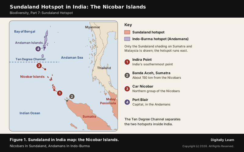
The Sundaland hotspot is the biodiversity hotspot of the Sunda Shelf: the Malay Peninsula, Sumatra, Java, Borneo and Bali, which were joined to mainland Asia whenever the sea fell in the ice ages. Sundaland in India means only the Nicobar Islands; the Andaman Islands, north of the Ten Degree Channel, belong to the Indo-Burma hotspot.
Biodiversity Hotspot Criteria and the Sunda Shelf Region
What Makes a Biodiversity Hotspot: Endemism and Habitat Loss
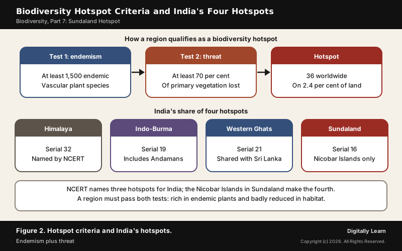
A biodiversity hotspot is a region rich in species found nowhere else that is losing its natural habitat fast. Norman Myers set out the idea in two articles in 1988 and 1990, and a revised analysis published in the journal Nature in 2000 fixed the two tests a region must pass.
- Endemism: At least 1,500 species of vascular plants found only there, more than 0.5 per cent of the world’s total.
- Threat: At least 70 per cent of its primary vegetation already lost.
- Result: 36 regions qualify; on 2.4 per cent of the planet’s surface they support nearly 60 per cent of the world’s plant, bird, mammal, reptile and amphibian species.
Hotspots are not only tropical. The list includes the Mediterranean Basin, the California Floristic Province, Japan, the Caucasus and the Mountains of Central Asia, alongside tropical regions such as Sundaland. Species richness counts, but only with the two tests: endemism and threat.
Sundaland Extent: Sunda Shelf, Ice-Age Land Bridges and the Wallace Line
Sundaland takes its name from the Sunda Shelf, a shallow extension of Southeast Asia's continental shelf that roughly follows the 120-metre depth line. It covers Bali, Borneo, Java and Sumatra with their small islands, and the Malay Peninsula on the mainland, about 1.8 million square kilometres in all.
The shelf was dry land again and again. When the sea fell by 30 to 40 metres or more, land bridges joined Borneo, Java and Sumatra to the Malay Peninsula and mainland Asia, and at the Last Glacial Maximum the sea fell about 120 metres and the whole shelf was exposed. This is why the islands still carry Asian mammals: elephants, monkeys, apes, tigers, tapirs and rhinoceros.
- Eastern edge: The Wallace Line, a deep-water channel never crossed by a land bridge; the islands east of it form Wallacea, a separate region.
- Western and southern edge: The deep Sunda Trench and the Indian Ocean.
- Climate: Most of Sundaland is everwet, with over 2,000 millimetres of rain a year and no predictable dry season.
- Forests: Lowland forest known for giant dipterocarp trees and orangutans.
Sundaland in India: Why Only the Nicobar Islands Qualify
The hotspot list names this region Sundaland, Indonesia and Nicobar Islands of India, number 16. The Nicobars lie about 150 kilometres northwest of Aceh on Sumatra and about 1,300 kilometres southeast of the Indian subcontinent, so where is Sundaland in India has a one-line answer: the Nicobar group, south of the Ten Degree Channel.
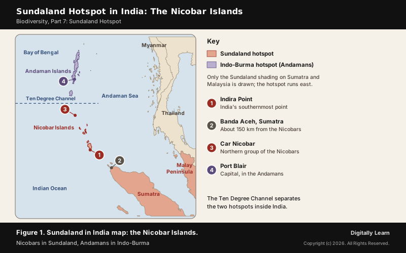
The Andamans fall in a different hotspot. They are counted in Indo-Burma, number 19, and in the ice ages they were linked to the Southeast Asian mainland. The Nicobars are not believed ever to have had a land bridge to the continent, though low seas joined Great Nicobar to Little Nicobar. The Ten Degree Channel, 150 kilometres wide and lying along the 10 degree north line of latitude, separates the two groups.
NCERT's Class XII Biology counts differently. On a list of 34 hotspots it names three for India: Western Ghats and Sri Lanka, Indo-Burma and Himalaya. The Nicobar share of Sundaland makes the fourth, which is why a question on how many biodiversity hotspots in India can be answered three or four depending on the list used. The Andamans' own hotspot is covered in Part 4 on Indo-Burma.
Nicobar Islands: Geography, Climate and Rainforest
Nicobar Islands Geography: Three Groups, Great Nicobar and Indira Point
The Nicobar Islands cover 1,841 square kilometres and had 36,844 people in the 2011 Census. They form the Nicobar district of the union territory of the Andaman and Nicobar Islands and fall into three groups.
| Group | Main islands | Note |
|---|---|---|
| Northern | Car Nicobar, Battimalv | Car Nicobar has an Air Force airstrip |
| Central | Chowra, Teressa, Katchal, Kamorta, Nancowry, Trinket | Katchal lost about 4,600 people in 2004 |
| Southern | Great Nicobar, Little Nicobar, Kondul, Pulo Milo | Great Nicobar is the largest island |
At 922 square kilometres, Great Nicobar is the largest island. Its highest point is Mount Thuiller at 642 metres, and its southern tip, Indira Point, is India's southernmost point. The islands are part of an island arc raised by the collision of the Indo-Australian Plate with Eurasia, the arc that includes the Arakan Yoma of Myanmar and the islands off western Sumatra.
Nicobar Islands Climate, Rainforest and Mangroves
The climate is warm and wet all year. Temperatures range from 22 to 30 degrees Celsius and rainfall is about 3,000 to 3,800 millimetres a year, so the islands carry tropical evergreen forest, which needs more than 200 cm of rain. The islands have an equatorial type of vegetation, fed by convectional rain.
- Coastal mangroves: India’s mangroves are most highly developed in the Andaman and Nicobar Islands and the Sundarbans.
- Interior forest: Evergreen and deciduous tropical moist broadleaf forest.
- Grasslands: Extensive inland grasslands on several islands, thought to result from human intervention.
- Ecoregion: The Nicobar Islands rainforests, a distinct terrestrial ecoregion with many endemic species.
The same seas that isolate the islands also expose them. On 26 December 2004 a tsunami 10 to 15 metres high struck the Nicobar coast. Teressa Island was reported split in two, and Indira Point subsided 4.25 metres, damaging its lighthouse.
Endemic Wildlife of the Nicobar Islands
Nicobar Megapode, Nicobar Treeshrew and Long-Tailed Macaque
Isolation from the mainland gave the Nicobars species found nowhere else. Three show the pattern best: a bird that lets rotting leaves hatch its eggs, a small mammal that split from its relatives in the Miocene, and a monkey that belongs to a Southeast Asian species.
| Species | Where | Status and feature |
|---|---|---|
| Nicobar megapode (Megapodius nicobariensis) | Nicobar Islands only | Vulnerable; incubates eggs in a mound |
| Nicobar treeshrew (Tupaia nicobarica) | Great and Little Nicobar | Endangered on the IUCN Red List |
| Nicobar long-tailed macaque | Great Nicobar, Little Nicobar, Katchal | Schedule I, Wildlife (Protection) Act 1972 |
The Nicobar megapode builds a large mound of soil and vegetation and leaves its eggs to be warmed by the heat of decomposition; the chicks climb out fully feathered and able to fly. The Nicobars sit on the western edge of the megapode range. The 2004 tsunami cut its population by an estimated 66 to 75 per cent and submerged Megapode Island completely.
The Nicobar treeshrew lives only on Great Nicobar and Little Nicobar, up to their highest points, and diverged from its relatives about 12 to 19 million years back. The Nicobar long-tailed macaque is a subspecies of the crab-eating macaque of Southeast Asia, a Sundaland link in a single animal.
Leatherback Turtle, Saltwater Crocodile and Other Nicobar Fauna
The beaches matter as much as the forest. From February to December the leatherback turtle, the largest turtle in the world, nests in Galathea National Park; in the Indian Ocean, nesting populations are known from Sri Lanka and the Nicobar Islands. The species is Vulnerable, and some of its subpopulations are Critically Endangered.
- Saltwater crocodile: Crocodylus porosus, recorded in the Great Nicobar Biosphere Reserve.
- Robber crab: The giant robber or coconut crab, Birgus latro.
- Reptiles: The reticulated python, the Andaman water monitor and the Malayan box turtle.
- Birds: The edible-nest swiftlet and the Nicobar pigeon.
- Scale: More than 1,800 animal species are recorded in the biosphere reserve.
The coast has coral deposits and fine beaches. The leatherback nests in Galathea National Park, and the transhipment port is planned at Galathea Bay on the same southern coast.
Great Nicobar Biosphere Reserve and Its National Parks
Great Nicobar Biosphere Reserve: Zones, Area and UNESCO Recognition
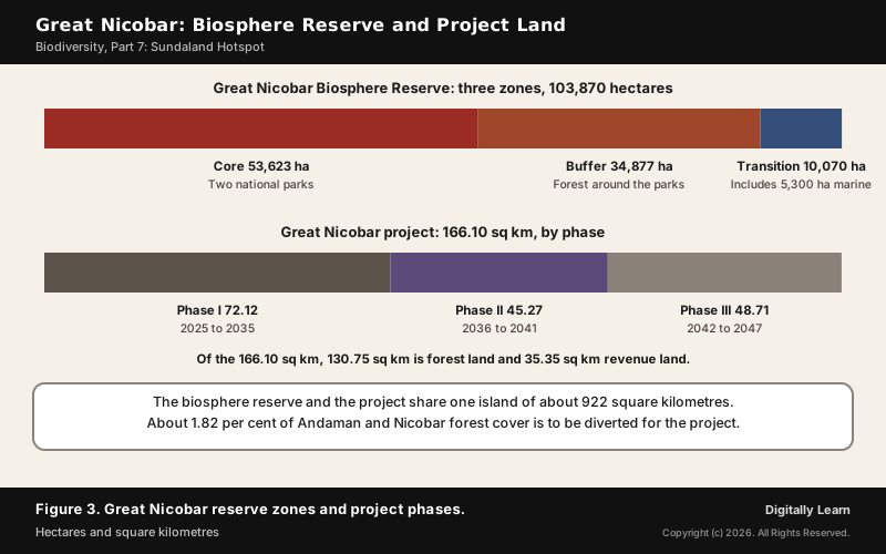
The Great Nicobar Biosphere Reserve was declared by the government in 1989 and added to UNESCO's World Network of Biosphere Reserves in 2013. It covers some 85 per cent of the island and includes the traditional lands of the Nicobarese and the Shompen.
| Zone | Area | What it holds |
|---|---|---|
| Core | 53,623 ha | Campbell Bay and Galathea national parks |
| Buffer | 34,877 ha | Forest land next to and between the two parks |
| Transition | 10,070 ha | Includes 5,300 ha of sea |
| Total of the zones | 103,870 ha | UNESCO's record: 104,400 ha terrestrial |
Both national parks were gazetted in 1992. Campbell Bay National Park, about 426 square kilometres in the north, is separated from the smaller Galathea National Park, about 110 square kilometres in the south, by a 12-kilometre forest buffer. Galathea is named after the Danish vessel that surveyed the island for minerals in 1845 to 1847.
The reserve spans tropical wet evergreen forest, mountain ranges and coastal plains. About 650 species of flowering plants, ferns, gymnosperms, mosses and lichens grow there, including rare endemics such as the tree fern Cyathea albosetacea and the orchid Phalaenopsis speciosa. UNESCO's record lists 14 mammal, 71 bird, 26 reptile, 10 amphibian and 113 fish species.
Shompen and Nicobarese: The People of the Nicobar Islands
Shompen and Nicobarese: PVTG Status and Island Life
Two indigenous peoples live on the Nicobars, the Nicobarese and the Shompen. Their six languages belong to the Austroasiatic family, which also includes Mon, Khmer, Vietnamese and India's Munda languages, another sign of the islands' Southeast Asian ties.
| Point | Shompen | Nicobarese |
|---|---|---|
| Status | Particularly Vulnerable Tribal Group | Scheduled Tribe |
| Where | Interior of Great Nicobar | Coastal settlements across the islands |
| Livelihood | Hunting and gathering | Mainly fishing |
| On Great Nicobar | About 237 | About 1,094 |
Contact with the Shompen has always been thin. They are among the most isolated peoples on earth, and most avoid outsiders; a polling station was first set up in their area for the 2014 election. The Shompen Policy of 2015 requires that large development proposals put the welfare and integrity of this Particularly Vulnerable Tribal Group first and follow a set consultation process.
The Nicobarese are the most significant tribal population of the whole territory, by their numbers and the wide area they occupy, larger than all the Andaman tribes together. Each island's people have their own name, but together they call themselves Holchu, which means friend. On Great Nicobar they once lived along the west coast; after the 2004 tsunami they moved to Afra Bay on the north coast and to Campbell Bay.
Great Nicobar Island Development Project: Plan and Debate
Great Nicobar Project Components: Transhipment Port, Airport, Power and Township
The Great Nicobar Project aims to turn the island into a maritime and economic hub. Its reasoning is geographic: Galathea Bay lies about 40 nautical miles from the East-West international shipping route and has natural water depth of over 20 metres, while India's own ports lack deep-water berths, so cargo is routed through Colombo, Singapore and Klang.
| Component | Scale |
|---|---|
| International Container Transhipment Terminal, Galathea Bay | 14.2 million TEU |
| Greenfield international airport | 4,000 peak-hour passengers |
| Gas and solar power plant | 450 MVA |
| Township | For the port-led workforce and services |
The project covers 166.10 sq km, of which 130.75 sq km is forest land and 35.35 sq km revenue land, and is phased: 72.12 sq km in 2025 to 2035, 45.27 sq km in 2036 to 2041 and 48.71 sq km in 2042 to 2047. A feasibility report was commissioned by NITI Aayog, and the Andaman and Nicobar Islands Integrated Development Corporation is developing it.
Environmental Clearance, Forest Diversion and Tribal Safeguards
The project was cleared under the EIA Notification, 2006 and the Island Coastal Regulation Zone Notification, 2019, after screening, scoping, public consultation and appraisal. The clearance carries 42 conditions covering air, water, noise, waste, marine ecology, health and disaster management.
- Forest diversion: 1.82 per cent of the forest cover of the Andaman and Nicobar Islands.
- Trees: About 18.65 lakh stand in the area; at most 7.11 lakh are to be felled, within 49.86 sq km, phase by phase.
- Green zones: 65.99 sq km kept free of tree felling.
- Compensatory afforestation: The islands already have over 75 per cent forest cover, so 97.30 sq km in Haryana compensates for the Phase I diversion of 48.65 sq km.
- Monitoring: Three independent committees, for pollution, biodiversity and the welfare of the Shompen and Nicobarese.
The tribal reserve is redrawn, not only reduced. Great Nicobar has 751.070 sq km notified as Tribal Reserve. Of the project land, 73.07 sq km of reserve is being de-notified and 76.98 sq km re-notified, a net addition of 3.912 sq km, and no relocation of tribal communities is proposed.
Great Nicobar Project Concerns: Ecology, Earthquakes and Indigenous Rights
The project has drawn scrutiny from environmental groups, researchers and opposition politicians. Their concerns are forest diversion, the effect on coastal and marine ecosystems, and the impact on the Shompen and the Nicobarese. The Zoological Survey of India's 2021 assessment noted that coral colonies in parts of the construction area would have to be translocated.
The island's geology adds a second risk. Great Nicobar lies in a seismically sensitive and cyclone-prone region, and in 2004 its southern tip sank as the tsunami washed away most coastal settlements. A risk assessment and a disaster management plan for tsunamis, earthquakes and cyclones are part of the clearance.
| Case for the project | Case for caution |
|---|---|
| Deep water close to the East-West shipping route | Rainforest, reefs and turtle beaches of a hotspot |
| Less dependence on Colombo, Singapore and Klang | About 7.11 lakh trees may be felled |
| Strategic and defence presence in the Andaman Sea | Shompen are among the most isolated peoples on earth |
| Airport and tourism connectivity | An active seismic zone that sank in 2004 |
Biogeographic Zones of India: Realms, Ten Zones and 27 Provinces
Biogeographic Realms of India: Indomalayan, Palearctic and Sundaland
Biogeography studies how species and ecosystems are spread over space and through time. At the widest level, the realm, all of India falls in the Indomalayan realm except the high Himalaya, which belongs to the Palearctic. Most of India lies in the Indian Subcontinent bioregion of that realm; the Nicobar Islands fall in its Sundaland bioregion.
The Himalaya is a biogeographic wall: the Hindu Kush, Karakoram and Himalaya divide the tropical and subtropical life of the subcontinent from the temperate Palearctic. Forests are classified separately. Champion drew up the first forest classification in 1936, revised by Seth in 1968, into five major groups, 16 type groups and over 200 types.
A third scheme works by habitat. The Worldwide Fund for Nature divides the world's land into 14 terrestrial biomes and 867 ecoregions, and 11 of those biomes occur in India. Its Global 200 list picks the ecoregions that are conservation priorities, and only two from India make it: the Western Ghats and the Eastern Himalayas.
Ten Biogeographic Zones of India by Rodgers and Panwar
How many biogeographic zones are there in India? Ten. W. A. Rodgers and H. S. Panwar of the Wildlife Institute of India drew up the scheme in 1988 while planning a protected area network, and divided the ten zones into 27 biogeographic provinces. No official scheme is mandated by the Government of India, but this one is the standard reference for the biogeographic regions of India.
| Zone | Key features |
|---|---|
| 1. Trans-Himalaya | Cold, arid, about 5.6 per cent of India; richest wild sheep and goat community in the world |
| 2. Himalaya | About 6.4 per cent of India; Palearctic in character |
| 3. Desert | Thar, 170,000 sq km in India, and the Rann of Kutch |
| 4. Semi-arid | Thorn forest between the desert and the Western Ghats |
| 5. Western Ghats | About 1,600 km from the tip of the Peninsula to the Tapi; 14 endemic caecilians |
| 6. Deccan Plateau | Largest unit of the Peninsular Plateau |
| 7. Gangetic Plain | Largest unit of the Great Plain |
| 8. North-East | Orchids, bamboos; wild relatives of banana, mango, citrus, pepper |
| 9. Coasts | West and east coast plains, deltas and mangroves |
| 10. Islands | Andaman and Nicobar, and Lakshadweep of coral origin |
The Islands zone joins two very different groups. The Arabian Sea islands such as Lakshadweep and Minicoy are the foundered remnants of an old landmass capped by coral formations, while the Bay islands belong to a mountain arc. The Rann of Kutch in the Desert zone holds the world's largest population of the Indian wild ass, in the Little Rann.
Biogeographic Zones and Hotspots: How Biodiversity Varies in India
Zones and hotspots answer different questions. A biogeographic zone covers all of India and sorts it by climate, landform and wildlife, so that the protected area network samples every kind of habitat. A hotspot picks out only the richest and most threatened places, for priority protection.
| Point | Biogeographic zone | Biodiversity hotspot |
|---|---|---|
| Covers | All of India, ten zones | Parts of India, in four hotspots |
| Basis | Climate, landform, flora and fauna | Endemic plants and habitat loss |
| Drawn up by | Wildlife Institute of India | Myers and Conservation International |
| Use | Planning protected areas | Setting global conservation priorities |
The law works at every level. The Biological Diversity Act, 2002 was passed to meet India's obligations under the Convention on Biological Diversity and provides for fair sharing of the benefits of biological resources and traditional knowledge. The National Biodiversity Authority, set up in 2003 at Chennai, must approve access by foreigners; Indian users go to their State Biodiversity Board, and local Biodiversity Management Committees work at the level of each local body.
Previous Year UPSC-CSE Questions
Previous Year UPSC-CSE Questions By the end you will be able to draft model answers for the following UPSC questions. Each question carries a collapsible framework showing how to approach it in the exam.
- UPSC Mains 2018 GS-IIIHow does biodiversity vary in India? How is the Biological Diversity Act, 2002 helpful in conservation of flora and fauna?
How to structure the answer in the exam
Introduction: India spans two biogeographic realms, ten zones and parts of four hotspots, so its biodiversity changes sharply over short distances.
Body (sub-themes to develop):
- Realms: Palearctic high Himalaya, Indomalayan rest of India, Sundaland bioregion in the Nicobars.
- Ten zones and 27 provinces: from the cold Trans-Himalaya to the coral islands.
- Hotspots: Himalaya, Indo-Burma, Western Ghats and Sri Lanka, Sundaland; endemism peaks there.
- Biological Diversity Act, 2002: NBA for foreign access, State Biodiversity Boards, local committees; benefit sharing.
Conclusion: Conclude that zone-wise protected areas and the Act's local committees together protect a biodiversity that varies zone by zone.
- UPSC Mains 2026 GS-IIIDiscuss how the contradiction between rapid infrastructure development and 'disaster-risk reduction' in ecologically-sensitive areas of India can be managed, with suitable examples.
How to structure the answer in the exam
Introduction: Infrastructure in fragile, hazard-prone areas raises exposure to disaster unless risk is built into the plan.
Body (sub-themes to develop):
- Example: the Great Nicobar Project in a seismically sensitive, cyclone-prone hotspot island.
- Hazard history: the 2004 tsunami; Indira Point subsided 4.25 metres.
- Tools: EIA Notification 2006, Island CRZ 2019, 42 conditions, risk assessment and disaster plan.
- Safeguards: phasing, green zones, independent monitoring committees.
Conclusion: Conclude that phasing, hazard mapping and independent monitoring can reconcile building with disaster-risk reduction.
- UPSC Mains 2025 GS-IVKeeping the national security in mind, examine the ethical dilemmas related to controversies over environmental clearance of development projects in ecologically sensitive border areas in the country.
How to structure the answer in the exam
Introduction: Projects in sensitive border areas pit national security against ecological and tribal rights.
Body (sub-themes to develop):
- Security and trade: deep water near the shipping route; less dependence on foreign ports.
- Ecology: rainforest, coral, leatherback beaches of the Sundaland hotspot.
- Rights: the Shompen Policy of 2015 and consultation with vulnerable tribes.
- Process ethics: transparency of clearance, independent monitoring, compensatory measures.
Conclusion: Conclude that security need not override due process: transparent clearance and tribal consent make the choice legitimate.
- UPSC Prelims 2011 Prelims-GSThree of the following criteria have contributed to the recognition of Western Ghats-Sri Lanka and Indo-Burma regions as hotspots of biodiversity:
- Species richness
- Vegetation density
- Endemism
- Ethno-botanical importance
- Threat perception
- Adaptation of flora and fauna to warm and humid conditions Which three of the above are correct criteria in this context?
How to approach this Prelims question
Approach: Keep only what the hotspot definition uses. A hotspot must hold at least 1,500 endemic vascular plants, which is endemism in a species-rich region, and must have lost at least 70 per cent of its primary vegetation, which is the threat. So species richness, endemism and threat perception are the criteria; vegetation density, ethno-botanical importance and adaptation to warm, humid conditions are not.
Trap to watch: Vegetation density and ethno-botanical value are not criteria.
Key facts to recall:
- (a) 1, 2 and 6: wrong. Vegetation density and adaptation to warm, humid conditions are not criteria.
- (b) 2, 4 and 6: wrong. None of these three is a hotspot criterion.
- (c) 1, 3 and 5: right. Species richness, endemism and threat perception.
- (d) 3, 4 and 6: wrong. Ethno-botanical importance and adaptation to climate are not criteria.
Answer signal: Species richness, endemism and threat perception, so option (c) is the answer.
- UPSC Prelims 2010 Prelims-GSConsider the following statements :
- Biodiversity hotspots are located only in tropical regions.
- India has four biodiversity hotspots i.e., Eastern Himalayas, Western Himalayas, Western Ghats and Andaman and Nicobar Islands.
Which of the statements given above is/are correct ?
How to approach this Prelims question
Approach: Check each statement against the hotspot list. Hotspots also exist outside the tropics, such as the Mediterranean Basin and Japan, so statement 1 fails. India's hotspots are the Himalaya, Indo-Burma, the Western Ghats and Sri Lanka, and Sundaland (which includes the Nicobar Islands); the Western Himalaya is not a separate hotspot, so statement 2 fails.
Trap to watch: The Western Himalaya is not a hotspot; the Mediterranean Basin and Japan are hotspots outside the tropics.
Key facts to recall:
- (a) 1 only: wrong. Temperate hotspots such as the Mediterranean Basin and Japan exist.
- (b) 2 only: wrong. The Western Himalaya is not listed as a hotspot of its own.
- (c) Both 1 and 2: wrong. Both statements are false.
- (d) Neither 1 nor 2: right. Both statements fail against the hotspot list.
Answer signal: Neither statement is correct, so option (d) is the answer.
- UPSC Prelims 2009 Prelims-GSConsider the following regions:
- Eastern Himalayas
- Eastern Mediterranean region
- North-western Australia
Which of the above is/are Biodiversity Hotspot(s)?
How to approach this Prelims question
Approach: Match each region to the hotspot list. The Eastern Himalayas fall in the Himalaya hotspot (number 32) and the Eastern Mediterranean in the Mediterranean Basin hotspot (number 14). Australia's hotspot is Southwest Australia (number 22), not the north-west.
Trap to watch: The Australian hotspot is Southwest Australia, not north-western Australia.
Key facts to recall:
- (a) 1 only: wrong. It leaves out the Eastern Mediterranean, part of the Mediterranean Basin hotspot.
- (b) 1 and 2 only: right. Both lie within listed hotspots.
- (c) 2 and 3 only: wrong. North-western Australia is not a hotspot, and the Eastern Himalayas are.
- (d) 1, 2 and 3: wrong. North-western Australia is not a hotspot.
Answer signal: Regions 1 and 2 are hotspots, so option (b) is the answer.
- UPSC Prelims 2017 Prelims-GSWhich of the following is geographically closest to Great Nicobar?
How to approach this Prelims question
Approach: Recall the nearest foreign land to the Nicobars. From Indira Point, the southern tip of Great Nicobar, to Rondo Island off Sumatra is about 145 km, and the Nicobars lie about 150 km north-west of Aceh. The other options are much farther.
Trap to watch: Java and Borneo are in Sundaland too, but much farther; Sri Lanka is across the Bay of Bengal.
Key facts to recall:
- (a) Sumatra: right. Rondo Island off Sumatra is about 145 km from Indira Point.
- (b) Borneo: wrong. It is part of Sundaland too, but much farther east.
- (c) Java: wrong. Also in Sundaland, but beyond Sumatra, farther away.
- (d) Sri Lanka: wrong. It lies across the Bay of Bengal, far to the west.
Answer signal: Sumatra is closest to Great Nicobar, so option (a) is the answer.
- UPSC Prelims 2009 Prelims-GSIn which one of the following places is the Shompen tribe found ?
How to approach this Prelims question
Approach: Place the tribe on its island. The Shompen, a Particularly Vulnerable Tribal Group, are hunter-gatherers of the interior of Great Nicobar, so the answer is the Nicobar Islands.
Trap to watch: The Shompen are not an Andaman tribe; they live on Great Nicobar.
Key facts to recall:
- (a) Nilgiri Hills: wrong. The Shompen do not live in the Western Ghats.
- (b) Nicobar Islands: right. They live in the interior of Great Nicobar.
- (c) Spiti Valley: wrong. It is a Himalayan valley, far from the Shompen's island home.
- (d) Lakshadweep Islands: wrong. These are in the Arabian Sea, not the Nicobars.
Answer signal: The Shompen live on Great Nicobar, so option (b) is the answer.
- UPSC Prelims 2008 Prelims-GSConsider the following statements:
- Salt-water crocodile is found in the Andaman and Nicobar Islands.
- Shrew and tapir are found in the Western Ghats of the Malabar region.
Which of the statements given above is/are correct?
How to approach this Prelims question
Approach: Test each animal against its real range. The saltwater crocodile is found in the Andaman and Nicobar Islands, including the Great Nicobar reserve: statement 1 holds. Tapirs are Sundaland mammals, not animals of the Western Ghats, so statement 2 fails as a whole.
Trap to watch: Tapirs are Sundaland mammals, not animals of the Western Ghats.
Key facts to recall:
- (a) 1 only: right. Saltwater crocodiles live in the Andaman and Nicobar Islands.
- (b) 2 only: wrong. Tapirs are not found in the Western Ghats.
- (c) Both 1 and 2: wrong. It includes the false statement 2.
- (d) Neither 1 nor 2: wrong. Statement 1 is true.
Answer signal: Only statement 1 is correct, so option (a) is the answer.
Sources and Further Reading
- NCERT: Biology (Class XII), Biodiversity and Conservation
- NCERT: India Physical Environment (Class XI), Physiography and Natural Vegetation
- PIB: Great Nicobar Project, Strategic Importance and Sustainable Development (1 May 2026)
- PIB: Great Nicobar Project, frequently asked questions
- PIB: Great Nicobar Project, strategic importance and sustainable development (document, May 2026)
- UNESCO: Great Nicobar Biosphere Reserve
- Wikipedia: Biodiversity hotspot
- Wikipedia: Sundaland
- Wikipedia: Nicobar Islands
- Wikipedia: Great Nicobar Biosphere Reserve
- Wikipedia: Great Nicobar Island Development Project
- Wikipedia: Biogeographic classification of India
- Wikipedia: Nicobar megapode
- Wikipedia: Shompen people
- Wikipedia: Biological Diversity Act, 2002
- UPSC: Previous year question papers
Editorial Disclaimer
This article is compiled from the reference materials listed in the Sources section. It is an explainer for UPSC preparation and is not a substitute for primary documents (NCERTs, GoI ministry releases, IMD bulletins, RBI / CEA / MoEFCC publications, and Standing-Committee reports).