


Overview
The satellite that watches the same ground continuously, and the orbit ISRO chose for it
ISRO placed the 2,367 kg EOS-05 into a sub-geosynchronous transfer orbit on 4 September 2026, then raised it towards a slot at 85.5 degrees East. It is India's first dedicated imaging satellite built for geosynchronous orbit, and the first ISRO launch after a pause of nearly eight months.
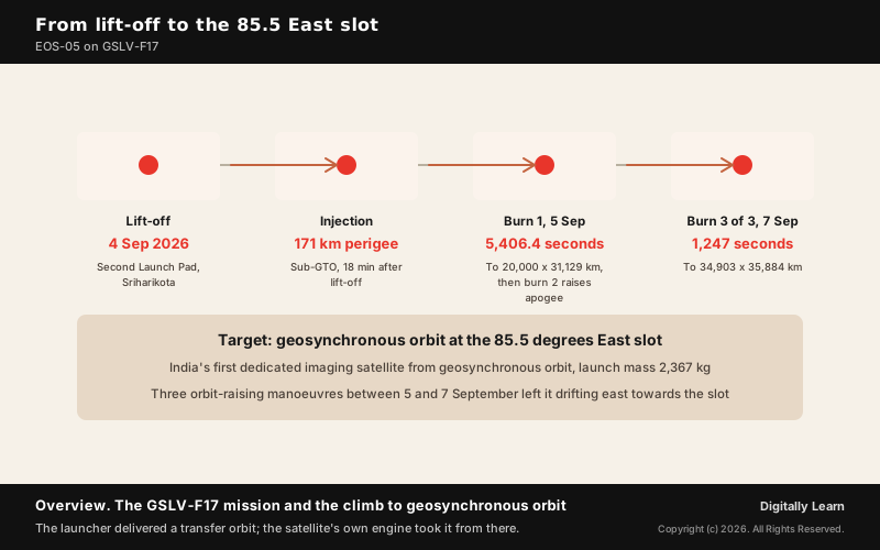
EOS-05, also designated GISAT-1A, is an Indian Earth observation spacecraft placed in orbit by the Geosynchronous Satellite Launch Vehicle GSLV-F17 on 4 September 2026. It is the first Indian imaging satellite intended to work from geosynchronous orbit, roughly 36,000 km above the Earth, where the satellite keeps pace with the rotation of the planet and can therefore watch the same broad region without the multi-day gaps that low-orbit imaging satellites cannot avoid.
The GSLV-F17 Mission: Launch, Sub-GTO Injection and Orbit Raising
Lift-Off From the Second Launch Pad at Sriharikota
GSLV-F17 lifted off at 2.55 a.m. IST on 4 September 2026 from the Second Launch Pad of the Satish Dhawan Space Centre at Sriharikota. ISRO records the flight as the nineteenth mission of the Geosynchronous Satellite Launch Vehicle.
The vehicle flew in its 4 metre diameter ogive configuration, a composite payload fairing shaped to carry a large satellite through the dense lower atmosphere. The spacecraft separated from the upper stage about eighteen minutes after lift-off.
ISRO describes EOS-05 as a state-of-the-art Earth observation spacecraft and as India's first ever imaging satellite from geosynchronous orbit, a capability the agency had attempted once before and lost. The satellite's launch mass is 2,367 kg.
Sub-GTO Injection and Why the Launcher Stops Short
The vehicle did not carry EOS-05 to its working altitude. It placed the satellite in a sub-geosynchronous transfer orbit, an elongated ellipse whose low point sits just above the atmosphere and whose high point reaches most of the way to the geosynchronous ring.
The achieved orbit had a perigee of about 171 km. The launcher's job ended there, because a medium-lift vehicle delivers a transfer orbit and leaves the circularisation to the spacecraft.
That division of labour is standard for geosynchronous missions and it matters for the fuel budget. Propellant saved during orbit raising is propellant available later for station keeping, which is what sets how many years a satellite can hold its assigned longitude against the drift imposed by lunar and solar gravity.
The Three Liquid Apogee Motor Burns and the Final Orbit
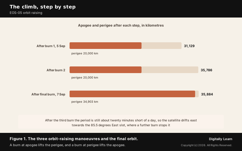
Raising the orbit fell to the satellite's own Liquid Apogee Motor. An engine burn changes the far side of an orbit rather than the point where it fires, so a burn at apogee lifts the perigee and a burn at perigee lifts the apogee. ISRO recorded the first manoeuvre as a burn of 5,406.4 seconds completed on 5 September 2026, which lifted the perigee from 171 km and left the orbit at about 20,000 km by 31,129 km.
Two more manoeuvres followed. The second raised the apogee to about 35,786 km, the altitude a circular orbit needs for a one-day period, and the third and final orbit-raising burn fired the engine for 1,247 seconds on 7 September, lifting the perigee again and leaving EOS-05 at about 34,903 km by 35,884 km. Station-keeping manoeuvres were still to come before the satellite could hold the 85.5 degrees East slot.
That sequence is worth separating from the launch. In the preceding year the navigation satellite NVS-02 reached transfer orbit safely and was then stranded when its orbit-raising operations could not be carried out. A launch is only half a mission when the spacecraft must finish the climb itself.
The Imaging Payload: Multispectral and Hyperspectral VNIR and SWIR
The I-2K Bus and the 700 mm Telescope
EOS-05 is built on the I-2K satellite bus, the two-tonne class platform ISRO has flown for communication and navigation spacecraft. Choosing a proven bus for a new kind of payload confines the novelty of the mission to the instrument it carries.
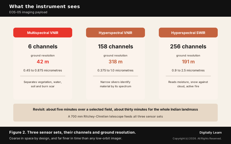
The instrument is built around a 700 mm Ritchey-Chretien telescope based on the design of the Cartosat-2A camera. That optical design folds a long focal length into a short tube using two hyperbolic mirrors, which is how an aperture of this size fits inside a satellite bound for a transfer orbit.
Aperture sets the limit on detail from 36,000 km. A larger mirror would resolve finer ground detail and would also add mass, and mass is the quantity a launch to geosynchronous transfer orbit is most constrained by, which is the trade that fixes this instrument's resolution.
Six Multispectral VNIR Channels at 42 Metre Resolution
Behind the optics sit detector arrays covering the visible and near-infrared region and the short-wave infrared region. The multispectral channel set uses the broadest bands of the three and returns the finest ground detail.
The multispectral channel set provides six bands between 0.45 and 0.875 micrometres at a ground resolution of 42 metres. Six broad bands are enough to separate vegetation from soil, water from cloud, and burnt ground from unburnt.
Forty-two metres is coarse beside the sub-metre imagery Indian low-orbit satellites return. The trade is deliberate, because resolution falls as distance grows and this instrument sits tens of times farther from the ground than a satellite in a few-hundred-kilometre orbit.
Hyperspectral Channels: Narrow Bands and Material Signatures
Beyond the six broad bands the payload carries two hyperspectral sensor sets. One covers the visible and near-infrared region in 158 channels between 0.375 and 1.0 micrometres at 318 metre resolution. The other covers the short-wave infrared in 256 channels between 0.9 and 2.5 micrometres at 191 metre resolution.
A hyperspectral sensor slices reflected light into hundreds of narrow slivers rather than a handful of wide ones. Materials that look alike in a broad band separate cleanly when their reflectance is sampled every few nanometres, because each substance absorbs at its own characteristic wavelengths.
The short-wave infrared set carries particular weight for Indian conditions. Water absorbs strongly in that region, so short-wave infrared bands read moisture in soil and vegetation, distinguish cloud from snow, and pick out active fire fronts that the visible bands render as smoke.
Revisit: Five Minutes for a Field, Thirty for India
The mission is specified to image a selected field of interest about every five minutes and to cover the whole Indian landmass about every thirty minutes. Those two numbers are the point of the entire mission.
A low-orbit imaging satellite passes over a given place, records a strip, and moves on. It returns after days, and if cloud covers the target on the pass, the next usable image may be a week away. A cyclone intensifies, a flood crest moves and a fire front spreads inside that gap.
What is the significance of this revisit rate is that it converts imaging from a survey into a watch. Thirty minutes is short enough to track a weather system as it develops and to see a flood advance while the water is still rising, which is the difference between a record of a disaster and a warning about one.
Geosynchronous Against Geostationary: The Orbit EOS-05 Uses
Eccentricity and Inclination: What Makes an Orbit Geostationary
A geosynchronous orbit is any orbit whose period equals one rotation of the Earth, about 23 hours and 56 minutes. That condition fixes the size of the orbit, its semi-major axis, at roughly 42,164 km from the centre of the Earth, but it leaves the shape and the tilt free.
A geostationary orbit is the special case in which the geosynchronous orbit is also perfectly circular and lies exactly in the plane of the equator. In the standard formulation it has an eccentricity of zero and an inclination of zero, and only then does its altitude sit uniformly at about 35,786 km with the satellite motionless above one point.
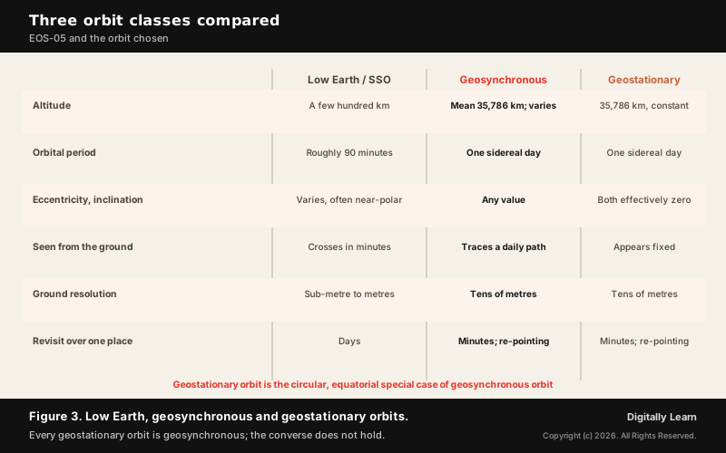
Every geostationary orbit is therefore geosynchronous, but the reverse does not hold. Give a geosynchronous orbit some tilt or some ellipticity and the satellite still returns to the same place once a day, yet it wanders north and south, or speeds up and slows down, in the course of that day.
The 85.5 Degrees East Slot and the Orbit Actually Chosen
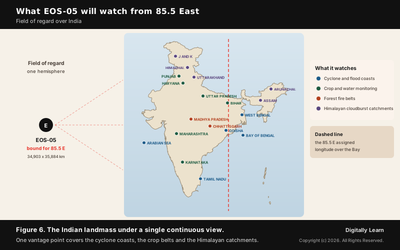
The assigned longitude is 85.5 degrees East, a position over the Bay of Bengal that puts the Indian landmass and a wide span of the Indian Ocean inside a single field of regard.
That orbit is close to the geosynchronous ring without yet being on it, and the article's own test shows why. Averaging the two altitudes and adding the radius of the Earth gives a semi-major axis of about 41,772 km, some 392 km short of the 42,164 km a one-day period requires.
A slightly smaller orbit is a slightly faster one. The period works out near 23 hours and 36 minutes, about twenty minutes short of a sidereal day, so the satellite gains on the rotating Earth and its ground track creeps roughly five degrees of longitude eastward each day. That is a drift orbit, and it is how a spacecraft walks to its assigned longitude before a final burn stops it there.
A slightly eccentric or inclined geosynchronous satellite is not stationary in the sky as seen from the ground. It traces a small closed path over the course of a day, which the pointing system must compensate for when the instrument is aimed at a fixed target.
Why a Geosynchronous Orbit Rather Than a Geostationary One
The reason for that choice has not been explained publicly. A scientist associated with the programme told the press only that each orbit is selected for a different purpose and that geosynchronous orbit was the one chosen here.
The silence is worth noticing, because a circular geostationary orbit is the more obvious fit for Earth observation. It holds the instrument over one point instead of letting the sub-satellite position wander, which is what an imaging mission would ordinarily want.
What can be said is what the record shows. Three burns left the satellite short of a period-matched orbit and still drifting, and station keeping was still to come. Whether the working orbit settles closer to circular is a question the operational record will answer rather than one the announcements have.
Why a Higher Orbit Trades Resolution for Persistence
Optical resolution falls as the distance from the target grows. A telescope that resolves well under a metre from a few hundred kilometres up resolves tens of metres from 36,000 km, because the same aperture now subtends a far larger patch of ground.
What the higher orbit buys is time. The satellite sees an entire hemisphere at once and never loses sight of it, so the limit on observation is how fast the instrument can be re-pointed rather than when the orbit next carries it overhead.
Why it matters is that the two capabilities are complements, not rivals. A coarse but continuous watch finds the event and tells an agency where to look, and a sharp but infrequent pass from a low-orbit satellite then supplies the detail. Neither replaces the other.
| Property | Low Earth / sun-synchronous | Geosynchronous (GSO) | Geostationary (GEO) |
|---|---|---|---|
| Altitude | A few hundred km | Mean about 35,786 km; varies if the orbit is eccentric | About 35,786 km, effectively constant |
| Orbital period | Roughly 90 minutes | One sidereal day | One sidereal day |
| Eccentricity and inclination | Varies; often near-polar | Any value | Both effectively zero |
| Apparent motion from ground | Crosses the sky in minutes | Traces a small closed path daily | Appears fixed |
| Ground resolution | Sub-metre to a few metres | Tens of metres | Tens of metres |
| Revisit over one place | Days | Minutes, set by re-pointing | Minutes, set by re-pointing |
Orbit Classes for Earth Observation: LEO, Sun-Synchronous and GEO
Low Earth and Sun-Synchronous Orbits and the Revisit Gap
Most imaging satellites fly in low Earth orbit, a few hundred kilometres up, and many of those use a sun-synchronous orbit. A sun-synchronous satellite crosses the equator at the same local solar time on every pass, so successive images of a place carry comparable illumination and shadow.
The cost of that consistency is coverage in time. The satellite images a narrow strip on each pass and the Earth turns beneath it, so the strip shifts westward from one orbit to the next. Returning to the same ground track takes days.
India's established imaging satellites sit in these orbits. The Cartosat series supplies cartographic detail, the RISAT series uses radar that sees through cloud and at night, and the Oceansat series observes ocean colour and winds. All of them trade cadence for detail.
India's Earlier Geostationary Payloads: The INSAT Weather Satellites
India has operated satellites in the geostationary ring for decades, but the ones that looked down were meteorological payloads of the INSAT series rather than dedicated imaging spacecraft. Their sensors were designed to watch cloud and temperature fields across a hemisphere.
A weather instrument and an Earth observation instrument ask different questions of the same light. The first wants broad thermal and moisture fields at modest spatial detail, while the second wants the surface itself, separated into vegetation, water, soil and built area.
EOS-05 is the first Indian spacecraft to carry the second kind of instrument to the first kind of orbit. That is the precise sense in which ISRO calls it India's first imaging satellite from geosynchronous orbit.
NavIC and the Mixed Geostationary and Geosynchronous Constellation
India's regional navigation system offers the clearest domestic illustration of the distinction. The Indian Regional Navigation Satellite System, operationally named NavIC, was designed with three satellites in geostationary orbit and four in inclined geosynchronous orbits rather than placing all of them on the equatorial ring.
The reason is geometric. A receiver fixing its position needs satellites spread across the sky, and a constellation parked entirely on the equatorial ring would leave users at northern latitudes looking at a line of transmitters low on the southern horizon.
Inclined geosynchronous satellites swing north and south of the equator each day, which lifts part of the constellation higher in the sky over India and improves the geometry of a fix. The system was built to serve India and a service area extending about 1,500 km beyond the country's borders, which is a regional footprint and not a global one.
India's Earth Observation Lineage: From IRS to the EOS Series
The Cartosat, RISAT and Oceansat Families
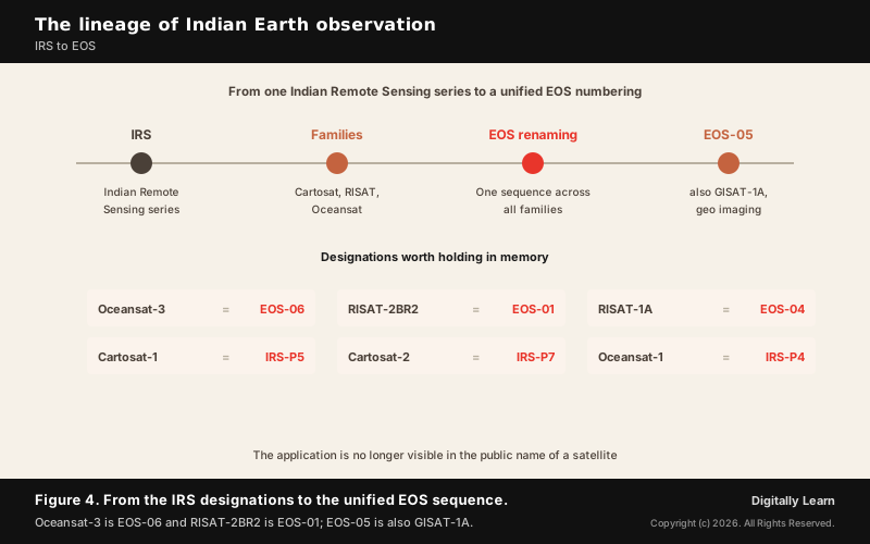
Indian Earth observation began with the Indian Remote Sensing programme, and the IRS designation ran underneath the later application-named families. Oceansat-1 carried the parallel designation IRS-P4, Cartosat-1 was IRS-P5 and Cartosat-2 was IRS-P7.
The families then specialised. Cartosat spacecraft carry high-resolution optical cameras for mapping, RISAT spacecraft carry synthetic aperture radar that works through cloud and darkness, and Oceansat spacecraft observe the sea surface.
Specialisation by application is why a single Indian imaging satellite never answered every question. Each family occupies a position in a trade space of resolution, swath, spectral range and revisit, and EOS-05 opens a corner of that space India had not occupied.
The EOS Renaming and Where EOS-05 Sits
ISRO later moved to a unified Earth Observation Satellite numbering that runs across the older families. RISAT-2BR2 became EOS-01, RISAT-1A became EOS-04 and Oceansat-3 became EOS-06, so a single EOS sequence now spans radar, optical and ocean instruments.
The renaming removes the application label from the public name of a satellite. A reader can no longer infer from the designation whether EOS-04 carries radar or a camera, which is why the mapping between the old and new names is worth holding in memory.
EOS-05 also carries the designation GISAT-1A, which places it in the Geo Imaging Satellite line rather than in the Cartosat or RISAT families. It is the second spacecraft of that line to be launched, and the first to reach orbit.
Beyond Earth Observation: Planetary Missions and Human Spaceflight
Earth observation is one arm of a wider record. The Mars Orbiter Mission, popularly called Mangalyaan, put an Indian spacecraft in orbit around Mars, and Chandrayaan-3 landed near the lunar south pole, a region no earlier mission had reached with a soft landing.
The programme has since extended in two directions. Aditya-L1 observes the Sun from the first Sun-Earth Lagrange point, and the Gaganyaan programme is developing an Indian human spaceflight capability, which is the exploratory work the 2023 policy directs the agency towards.
Cooperation runs through the same record. NISAR, built jointly by ISRO and NASA, was launched on 30 July 2025 on a GSLV and carries dual-frequency radar for measuring change in land and ice, which places the flagship Earth observation partnership alongside the national programme rather than outside it.
The GSLV and Its Cryogenic Upper Stage
The Cryogenic Upper Stage and Why It Is Hard
The GSLV is a three-stage vehicle whose final stage burns liquid hydrogen and liquid oxygen. Cryogenic propellants deliver more thrust per kilogram of fuel than the storable liquids used lower down, which is what allows a medium-lift rocket to reach transfer orbit with a two-tonne satellite.
They also impose the hardest engineering in the vehicle. Liquid hydrogen boils near 20 kelvin and liquid oxygen near 90 kelvin, so both must be held far below ordinary temperatures, pumped through turbomachinery without freezing the bearings, and ignited reliably in vacuum after a long coast.
The GSLV earned the informal reputation of a difficult vehicle across four failures in its flight record, the last of them the 2021 mission described below. The record since has been steadier, and the vehicle has carried payloads in the two-tonne class to both geosynchronous transfer and sun-synchronous orbits.
PSLV, GSLV and GSLV Mark III: Roles and Staging
India operates the two vehicles for different jobs. The Polar Satellite Launch Vehicle has long carried Earth resources and remote sensing satellites into low and sun-synchronous orbits, while the GSLV was developed mainly to place communication satellites into geosynchronous transfer orbit.
That division is a tendency rather than a rule, and the vehicle's recent record shows it. One flight earlier the same launcher carried NISAR, an Earth observation satellite, into a sun-synchronous orbit, so a GSLV had already flown an imaging payload away from the geosynchronous ring before EOS-05 flew one towards it.
It is also worth separating the vehicles by staging. The GSLV uses three stages with a cryogenic upper stage, whereas the larger LVM3, long known as GSLV Mark III, is a three-stage vehicle with two solid strap-on boosters, a liquid core and a cryogenic upper stage. Neither is a four-stage vehicle; the four-stage configuration belongs to the PSLV.
The 2021 GSLV-F10 Failure and the GISAT-1A Replacement
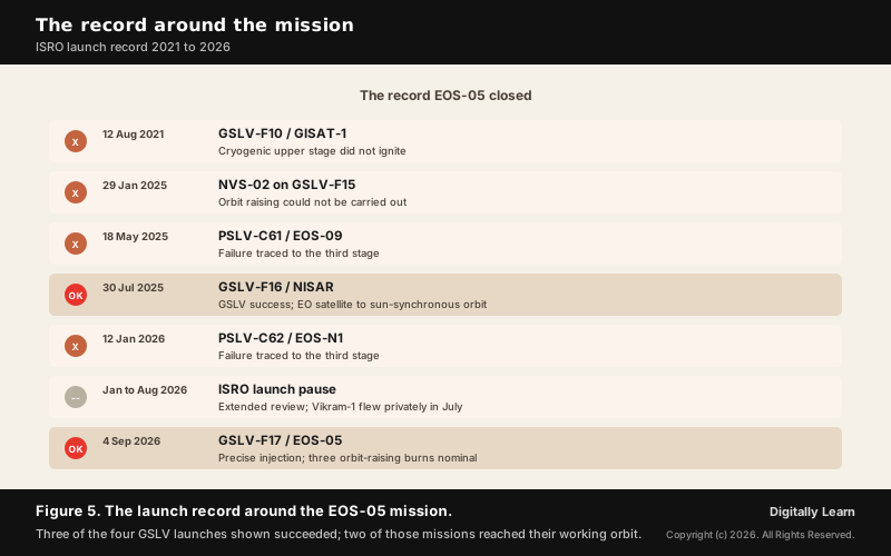
The first attempt at an Indian geo imaging satellite failed. On 12 August 2021 the GSLV-F10 mission carrying EOS-03, also known as GISAT-1, performed normally through its first and second stages, and then the cryogenic upper stage did not ignite because of a technical anomaly.
The satellite was lost, and with it the capability it was meant to establish. EOS-05 carries the designation GISAT-1A because it is the replacement for that spacecraft, built to deliver the same near real-time imaging from the geo platform.
The capability India set out to build in 2021 arrived five years later, on the nineteenth flight of the vehicle that had denied it. The same cryogenic stage that ended the first attempt carried the second one to orbit.
The 2025 and 2026 Failure Record and the Launch Pause
PSLV-C61, PSLV-C62 and the Third-Stage Anomalies
The workhorse failed twice in succession. PSLV-C61 carrying the EOS-09 satellite failed on 18 May 2025, and PSLV-C62 carrying EOS-N1 failed on 12 January 2026. Both failures were traced to the third stage of a vehicle that had flown reliably since the 1990s.
ISRO then slowed its launch cadence sharply. Missions scheduled for the first part of 2026 were held while the agency put subsequent vehicles through extended review, and the mission was reported in the press to have been ready months before it flew.
The pause cost ISRO most of a year of launch cadence and bought confidence in the next flight. It was not a pause in Indian launches: Skyroot's Vikram-1 reached orbit from Sriharikota on 18 July 2026, the first Indian private orbital launch, inside the same window.
The NVS-02 Orbit-Raising Failure and Why This Burn Mattered
A third failure belonged to the spacecraft rather than the launcher. The navigation satellite NVS-02, placed in transfer orbit by GSLV-F15 in January 2025, never reached its working orbit.
That history is why the three LAM burns on EOS-05 counted as a separate success from the launch. A satellite delivered correctly to transfer orbit is still a satellite in the wrong orbit until its own propulsion works.
Taken together the failures spread across two PSLV flights and one spacecraft, which is why a single clean flight settles less than it appears to. Dependability in launch is a property of a whole system, covering the vehicle, the upper stage and the satellite's own propulsion.
What EOS-05 Will Watch: Disasters, Agriculture and the Sea
Cyclones, Floods, Cloudbursts and Forest Fires
The stated applications begin with rapid-onset natural hazards: cyclones, floods, cloudbursts and forest fires. Each of these changes materially within hours, which is the timescale a low-orbit satellite cannot follow and a geosynchronous one can.
A cyclone in the Bay of Bengal is the clearest case. From 85.5 degrees East the whole basin lies in view continuously, so the track and the structure of the storm can be sampled repeatedly while it approaches the coast rather than reconstructed from occasional passes.
Fire detection works on a different principle. Burning ground radiates strongly in the short-wave infrared, so the hyperspectral short-wave sensor can pick out an active front through smoke that obscures the visible bands, and repeat the observation often enough to show which way the fire is moving.
- Cyclones: continuous tracking of a system across the Bay of Bengal and the Arabian Sea rather than snapshots.
- Floods: observation of an advancing crest while water levels are still rising.
- Cloudbursts and landslides: repeated looks at Himalayan catchments where terrain changes precede failures.
- Forest fires: short-wave infrared detection of active fronts and of burn scars after the event.
Crops, Forests, Water Bodies and Land Use
The slower applications matter as much. Crop condition, forest cover, the extent of water bodies and patterns of land use all change over weeks and seasons, and all of them are read from how the surface reflects light in different bands.
Frequent observation helps here for a reason particular to India. Cloud cover during the monsoon defeats optical satellites, and a sensor that looks every thirty minutes has far better odds of catching a clear window over a given district than one that looks every few days.
Stubble burning illustrates the timing problem directly. Burning that occurs outside the narrow window when a sun-synchronous satellite crosses overhead can be undercounted, and a sensor watching continuously through the day removes that particular blind spot from the estimate.
Maritime Domain Awareness and Strategic Surveillance
Security surveillance appears among the satellite's stated applications, and ISRO's chairman described EOS-05 in remarks to the press as providing important strategic data for the country. A permanent view across the northern Indian Ocean supports awareness of activity at sea in a way periodic passes cannot.
The value for a maritime service is persistence rather than sharpness. Knowing that something has changed in a broad area, and knowing it within the hour, is what allows a sharper asset to be directed to the right place.
The value depends on institutions as much as on the spacecraft. Continuous wide-area observation feeds the same bodies that run cyclone warning and coastal surveillance, and its usefulness rests on those agencies receiving and acting on the data.
Space Sector Governance: ISRO, NSIL and IN-SPACe After 2023
What the Indian Space Policy 2023 Assigns to Each Body
The Indian Space Policy of 2023 separated functions that had sat together in one organisation. ISRO is directed towards research, new technology and new systems, and away from routine operational and manufacturing work.
NewSpace India Limited, the commercial undertaking under the Department of Space, is tasked with commercialising space technologies and operating launch vehicles and infrastructure on a demand-driven basis. The Indian National Space Promotion and Authorisation Centre is the single-window body that authorises and supervises space activity by non-governmental entities.
The policy also opens end-to-end activity to private participants, including building satellites and launch vehicles and disseminating data, and allows them to use ISRO facilities. The intent is a sector in which the agency stops being the only actor.
| Body | Assigned role |
|---|---|
| ISRO | Research and development, new technologies and systems; transition away from routine operations and manufacturing |
| NSIL | Commercialisation of space technologies and platforms; operating launch vehicles and infrastructure, demand-driven |
| IN-SPACe | Single-window authorisation, promotion and supervision of non-governmental space activity |
| Private entities | End-to-end activity including satellites, launch vehicles and data services |
Staffing, Recruitment and the Outsourcing of Core Functions
The mission's success arrived alongside a public disagreement about what the policy means for the agency's own staff. Employee associations wrote to the ISRO chairman seeking clarity on staffing, recruitment and the outsourcing of core functions.
ISRO responded that the agency would not be privatised or reduced, and IN-SPACe said the agency would not be diminished and that the role of industry must grow. Neither formulation addresses the narrower question the associations asked, which concerns posts and recruitment rather than the survival of the organisation.
The question is genuinely open rather than merely institutional. An agency directed towards research and away from production has to decide what happens to the skills and the people that production employed, and a policy silent on posts and recruitment leaves the answer to be improvised.
Space Technology as a Tool of Social Development
The Indian space programme was founded on an unusual premise for its time. Rather than pursuing prestige in a space race, it justified itself by the application of space technology to the problems of a developing society, in communication, education, weather and resource survey.
EOS-05 sits comfortably inside that tradition. Its stated applications run from disaster monitoring to agricultural assessment, which are development functions before they are strategic ones, and its value is realised on the ground rather than in orbit.
The tension the current debate exposes is about which justification now governs. A sector measured by export earnings and startup counts answers to a different test from one measured by whether a flood warning reached a district in time.
India in the Global Space Order: Partnerships and Comparison
Cooperation on Human Spaceflight, Lunar and Venus Missions
The launch came during a period of active discussion between Indian and European space agencies on cooperation in human spaceflight and in lunar and Venus missions. Those are exactly the exploratory areas the 2023 policy directs ISRO towards.
Cooperation of this kind is a form of capability transfer in both directions. India brings a demonstrated record of low-cost planetary missions and a launch industry, and gains access to experience in crewed operations that no single national programme accumulates quickly.
The practical significance for the observation programme is indirect but real. An agency that carries international partners on exploratory missions has more reason to hand routine operational work, including satellite production, to industry at home.
Where a Geo Imaging Capability Places India
Continuous imaging from the geostationary ring is not new globally. Weather agencies have watched hemispheres from that altitude for decades, and China has operated Gaofen 4, a geostationary optical imaging satellite, since 2015. What is new for India is placing a land-observation instrument there rather than a meteorological one.
The comparison that matters for policy is with China, whose space programme operates at a scale and cadence India does not match. Cadence, meaning how many missions fly and how reliably, is the measure on which the ISRO launch pause of 2026 registers most sharply.
The commercial question is no longer hypothetical. Persistent wide-area imagery is a saleable data product as well as a public good, and the private orbital launch of July 2026 showed that the ecosystem the 2023 policy set out to build now reaches orbit on its own.
Limits and Open Questions: Resolution, Data Access and Cadence
Coarse Ground Resolution and What Persistence Cannot Replace
The instrument's finest ground resolution is 42 metres in the multispectral bands and coarser still in the hyperspectral sets. At that scale a building is invisible, a road is a hint, and a small field is a single sample.
Applications that need to identify objects therefore remain with the low-orbit satellites, and applications that need to see through cloud remain with radar. EOS-05 adds a dimension to the constellation rather than an upgrade to it.
The honest description of the mission is a change in what Indian Earth observation can do, not an improvement in how well it does what it already did. Claims that treat a coarse continuous sensor as a sharper eye misdescribe the capability.
Data Reception, Processing and the Route to Users
Imagery becomes useful when somebody turns it into a decision. A satellite returning a picture of the Indian landmass every thirty minutes generates a volume of data that has to be processed, interpreted and delivered before the next observation arrives.
That places the binding constraint on the receiving end rather than on the spacecraft. Reception, processing and dissemination of Indian satellite data run through the National Remote Sensing Centre, with meteorological and oceanographic data archived through MOSDAC at the Space Applications Centre, and public access mediated through platforms such as Bhuvan.
A third open question concerns cadence. One clean flight after three failures does not establish reliability, and the measure of the programme over the coming year is how many missions fly and how many reach their intended orbits.
UPSC Relevance: GS-III Space Technology and the Prelims Pointers
Syllabus Fit Across General Studies Papers II and III
The topic sits in the General Studies Paper III segment on awareness in the field of space, and it reaches Paper II through the governance question about how a public agency and private industry divide the work of a strategic sector.
For Prelims the reliable pointers are the launch date of 4 September 2026, the GSLV-F17 vehicle on its nineteenth flight, the 2,367 kg satellite mass, the 85.5 degrees East slot, the distinction between geosynchronous and geostationary orbits, and the EOS renaming of the older satellite families.
For Mains the productive framing is the application of space technology to development. EOS-05 supplies a concrete recent example for answers on disaster management, agriculture and resource monitoring, and the 2023 policy supplies the institutional half of the same answer.
The Traps This Topic Sets and the Mains Angles It Opens
Four traps recur on this material, and each has caught candidates before.
- Geosynchronous is not geostationary. Only a circular equatorial orbit holds a satellite over one point.
- The PSLV is the four-stage vehicle. The GSLV and LVM3 are three-stage.
- Orbit raising is the satellite’s own work. The launcher stops at the transfer orbit.
- The EOS numbers run across the older families. They did not replace any one of them.
EOS-05 supplies a worked example of the first trap. Its orbit after the third burn has a period about twenty minutes short of a day, so it drifts eastward rather than hanging over one place, which is the difference a question can be built on.
Two Mains angles open beyond the obvious one. The staffing dispute is a governance question about what a public agency does when policy moves production to industry, and the data-to-decision chain is an administrative capacity question rather than a technological one, since the binding constraint sits with the institutions that turn imagery into warnings.
Previous Year UPSC-CSE Questions By the end you will be able to draft model answers for the following UPSC questions. Each question carries a collapsible framework showing how to approach it in the exam.
- UPSC Mains 2016 GS-IIIDiscuss India’s achievements in the field of Space Science and Technology. How the application of this technology has helped India in its socio- economic development?
How to structure the answer in the exam
Introduction: Open with the founding orientation of the Indian space programme towards development applications rather than prestige, then state the two capabilities the answer will trace.
Body (sub-themes to develop):
- Launch capability: PSLV for low and sun-synchronous orbits, GSLV with its cryogenic upper stage for geosynchronous transfer.
- Satellite families: Cartosat for mapping, RISAT for all-weather radar, Oceansat for the sea, and now EOS-05 for continuous wide-area observation from geosynchronous orbit.
- Development applications: disaster warning for cyclones and floods, crop and forest monitoring, water resources, and communication and education services.
- Institutional delivery: the Indian Space Policy 2023 role split between ISRO, NSIL and IN-SPACe, and the dependence of value on data reaching users.
Conclusion: Close on the test that matters for a development-oriented programme, which is whether the capability changes outcomes on the ground rather than whether it adds to a list of firsts.
Relevance to this topic. The question asks for two things, a record of achievement and the development uses that record was put to. EOS-05 supplies a current instance of both halves: a capability India did not previously hold, and a set of declared applications in disaster warning, agriculture, forestry and water that are development functions rather than prestige ones. The founding premise of the Indian programme, that space technology exists to serve a developing society, is the thread the answer should follow.
- UPSC Prelims 2018With reference to the Indian Regional Navigation Satellite System (IRNSS), consider the following statements:
- IRNSS has three satellites in geostationary and four satellites in geosynchronous orbits.
- IRNSS covers entire India and about 5500 sq. km beyond its borders.
- India will have its own satellite navigation system with full global coverage by the middle of 2019.
Which of the statements given above is/are correct?
How to approach this Prelims question
Approach: Test each statement independently. Statement 1 describes the design of the constellation. Statement 2 gives the service area as about 5500 square kilometres beyond the borders, which is both the wrong unit and the wrong magnitude for a footprint measured in distance, not area. Statement 3 claims full global coverage, which conflicts with the word Regional in the system's own name.
Trap to watch: The word Regional in Indian Regional Navigation Satellite System settles statement 3 on its own, and a system built for a region does not acquire full global coverage on a date.
Key facts to recall:
- Three satellites sit in geostationary orbit and four in inclined geosynchronous orbits.
- Inclined geosynchronous satellites improve the geometry of a position fix over Indian latitudes.
- The service area extends about 1,500 km beyond India's borders, a distance rather than an area, and is regional rather than global.
Answer signal: Only the first statement survives testing.
Relevance to this topic. The first statement of this question turns on precisely the distinction EOS-05 forces a reader to make, between satellites placed in the geostationary ring and satellites placed in inclined geosynchronous orbits. A candidate who has understood why NavIC mixes the two, and why ISRO chose the broader geosynchronous orbit for EOS-05 rather than a strictly geostationary one, can settle statement 1 without recall.
- UPSC Prelims 2018With reference to India’s satellite launch vehicles, consider the following statements:
- PSLVs launch the satellites useful for Earth resources monitoring whereas GSLVs are designed mainly to launch communication satellites.
- Satellites launched by PSLV appear to remain permanently fixed in the same position in the sky, as viewed from a particular location on Earth.
- GSLV Mk III is a four-staged launch vehicle with the first and third stages using solid rocket motors; and the second and fourth stages using liquid rocket engines.
Which of the statements given above is/are correct?
How to approach this Prelims question
Approach: Separate the vehicle from the orbit. Statement 1 is about typical payloads and holds as a tendency. Statement 2 confuses the orbit a PSLV reaches with the geostationary ring. Statement 3 is a staging claim that can be checked against the configuration of LVM3.
Trap to watch: A satellite appears fixed in the sky only from a geostationary orbit. PSLV payloads in low and sun-synchronous orbits cross the sky in minutes, so statement 2 cannot stand.
Key facts to recall:
- PSLV has carried Earth resources and remote sensing satellites to low and sun-synchronous orbits.
- GSLV was developed mainly for communication satellites bound for geosynchronous transfer orbit, and uses a cryogenic upper stage.
- LVM3, earlier called GSLV Mark III, is a three-stage vehicle with two solid strap-on boosters, not a four-stage vehicle.
Answer signal: Only the first statement survives testing.
Relevance to this topic. EOS-05 is the exception that makes this question memorable. Statement 1 describes the usual division of labour between the two vehicles, and the EOS-05 mission departs from it because an Earth observation payload was bound for the geosynchronous ring, which is the GSLV's purpose. Statement 2 attributes a geostationary property to PSLV payloads, and statement 3 misstates the staging of LVM3, both of which the vehicle sections of this article address.
Sources
- GSLV-F17/EOS-05 Mission
- Indian Space Policy 2023
- Orbit manoeuvring of EOS-05 spacecraft
- Prime Minister lauds ISRO for successful launch of GSLV-F17 carrying EOS-05
- Indian Space Policy 2023 opens the sector to non-government entities across the value chain
- National Remote Sensing Centre
- Meteorological and Oceanographic Satellite Data Archival Centre
- Bhuvan
- Catalog of Earth Satellite Orbits
- EOS-05
- Indian Regional Navigation Satellite System
- Geosynchronous Satellite Launch Vehicle
- NISAR
- EOS-04
- Polar Satellite Launch Vehicle
- LVM3
- Oceansat-3
- Gaofen
- Chandrayaan-3
- Mars Orbiter Mission
- Aditya-L1
- Gaganyaan
- EOS-01
- EOS-09
- Cartosat-1
- Cartosat-2
- Oceansat-1
- NVS-02
- List of GSLV launches
- PSLV-C62
- Vikram (rocket)
- 2026 in spaceflight
- RISAT
- Liquid hydrogen
- Liquid oxygen
- Low Earth orbit
- Sun-synchronous orbit
Editorial Disclaimer
This briefing is prepared for examination preparation. Readers should consult the primary sources listed above for official details.


