

Overview
The Pacific Ring of Fire, also called the circum-Pacific belt, is a horseshoe-shaped belt of earthquakes and volcanoes about 40,000 km long around the Pacific Ocean. It holds about 90 per cent of the world's earthquakes and around two-thirds of its active or dormant volcanoes, because all round the Pacific, oceanic plates are sinking beneath their neighbours in a process called subduction.
Ring of Fire Meaning: Shape, Size and Key Figures
What Is the Pacific Ring of Fire?
The belt is up to about 500 km wide and is also known as the Rim of Fire or the Girdle of Fire. It is not one single structure but a chain of plate boundaries where oceanic plates sink beneath the plates next to them.
The belt is a horseshoe, not a closed ring. It runs from the southern tip of South America, along the west coast of North America, across the Bering Strait, down through Japan and into New Zealand. The south of the Pacific stays open because the plate boundaries there, the East Pacific Rise, the Pacific-Antarctic Ridge and the Chile Ridge, pull apart instead of colliding. The name comes from the many active volcanoes along the rim of the Pacific.
How Many Volcanoes: Why Counts Differ from 450 to 915
Sources give different numbers for the Ring's volcanoes, and the gap is about definition, not error. The narrowest count puts the Ring at more than 450 volcanoes. Broader counts put the number of active or dormant volcanoes between 750 and 915, around two-thirds of the world total; the exact figure depends on which regions are included. More than 350 of them have erupted in historical times.
Geologists agree on most of the Ring but differ on a few edges:
- Western Indonesia: Sumatra, Java and Krakatoa sit above a subduction zone in the Indian Ocean. News media and some geologists include them; many geologists place them in the Alpide belt instead.
- Antarctic Peninsula and South Shetland Islands: Some geologists include them, others do not.
- Izu, Bonin and Mariana Islands: Some geologists leave them out.
Circum-Pacific Belt and the Alpide Belt Compared
The world has two great belts of earthquakes, and the circum-Pacific belt is the larger. The second is the Alpide belt, also called the Alpine-Himalayan belt, which runs from the northern Atlantic through southern Europe and the Himalayas to central Indonesia and has 5 to 6 per cent of the world's earthquakes and 17 per cent of its largest ones. On a world map of earthquake epicentres, the two show up as bands, one along the Alpide belt and one along the rim of the Pacific.
| Feature | Ring of Fire | Alpide belt |
|---|---|---|
| Share of earthquakes | About 90 per cent | 5 to 6 per cent |
| Largest earthquakes | Most of them | 17 per cent |
| Main process | Oceanic plates subduct round the Pacific | Tethys Ocean closed; continents collide |
| Mountains | Andes, Cascades, island arcs | Alps, Hindu Kush, Himalayas |
| Link to India | None | Himalayas, Andaman and Nicobar |
Where Is the Pacific Ring of Fire Located? Map and Countries
Pacific Ring of Fire on the World Map
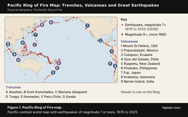
Earthquakes of magnitude 7 or more trace the Ring more clearly than any line drawn on a map. The US Geological Survey lists 696 earthquakes of that size worldwide from 1976 to 2025, and most of them crowd along the rim of the Pacific, from Chile round to New Zealand.
Pacific Ring of Fire Countries, Region by Region
The Ring runs past more than two dozen countries on both sides of the Pacific, and in each region a different oceanic plate is sinking to build their volcanoes.
| Region | Countries | Plates |
|---|---|---|
| South America | Chile, Argentina, Bolivia, Peru, Ecuador, Colombia | Nazca and Antarctic plates under the South American plate |
| Central America and Mexico | Guatemala, El Salvador, Honduras, Nicaragua, Costa Rica, Mexico | Cocos plate, and the Rivera plate in Mexico |
| North America | USA, Canada | Juan de Fuca and Pacific plates under the North American plate |
| North Pacific | Russia (Kamchatka, Kuril Islands), USA (Aleutians) | Pacific plate under the North American plate |
| East Asia | Japan, Taiwan, Philippines | Pacific, Philippine and Eurasian plates |
| Southwest Pacific | Papua New Guinea, Solomon Islands, Vanuatu, Fiji, Samoa, Tonga, New Zealand, eastern Indonesia | Pacific and Australian plates |
Japan alone holds about 10 per cent of the world's active volcanoes, formed by the Pacific plate and the Philippine plate sinking beneath it. Indonesia is a special case, because it lies where the Ring of Fire meets the Alpide belt, so its eastern islands belong to the Ring and its western islands are often placed in the Alpide belt.
Why the Ring of Fire Exists: Subduction at Convergent Plate Boundaries
How Subduction Causes Earthquakes and Volcanoes
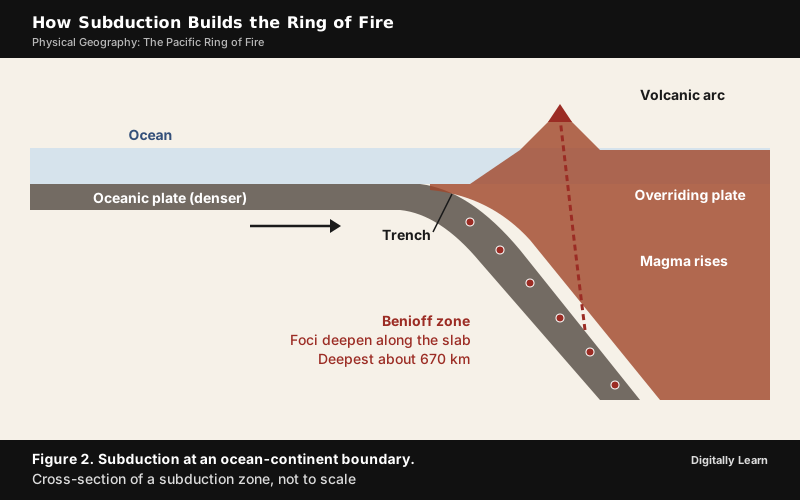
The Ring exists because the floor of the Pacific is being pushed beneath the plates around it. The place where one plate sinks under another is called a subduction zone. Cold oceanic lithosphere is slightly denser than the hot mantle below it, so once it starts to sink, the slab is pulled down largely by its own weight.
- The plates meet: An oceanic plate moves towards another plate at a convergent boundary.
- The ocean plate bends down: It sinks at a deep, narrow trench in the sea floor.
- Stress builds and breaks: The plates lock, stress builds up, and it is released in earthquakes, some of the largest on Earth.
- Water leaves the slab: Deep down, fluids from the sinking slab rise into the mantle above and lower its melting temperature. This is called flux melting.
- Magma rises: The magma is less dense than the rock around it, so it rises and feeds a line of volcanoes, the volcanic arc, on the plate above.
Plates can converge in three ways, between an oceanic and a continental plate, between two oceanic plates, and between two continental plates. The first two build the Ring of Fire. The third, a collision of continents, raised the Himalayas and belongs to the Alpide belt. Every kind of convergence produces earthquakes, and the two kinds with subduction also feed volcanoes, so most of the world's earthquakes and volcanoes occur where plates meet.
Oceanic Trenches of the Pacific Ring of Fire
Where the ocean plate bends down, it leaves a long, deep trench in the sea floor, and trenches line almost the whole Ring. The Mariana Trench in the western Pacific is the deepest oceanic trench on Earth, about 2,550 km long, with a maximum known depth of 10,935 m at the Challenger Deep.
| Trench | Ocean | Key fact |
|---|---|---|
| Aleutian | North Pacific | Pacific plate under the North American plate, closing at 7.5 cm a year |
| Kuril-Kamchatka | Northwest Pacific | Off Kamchatka and the Kuril Islands |
| Mariana | Western Pacific | Deepest trench: 10,935 m |
| Tonga, Kermadec | South Pacific | Kermadec runs about 1,000 km north from New Zealand |
| Peru-Chile | Eastern Pacific | About 5,900 km long; 8,065 m deep |
| Sunda | Indian Ocean | Indo-Australian plate under the Sunda and Burma plates |
| South Sandwich | South Atlantic | Not on the Ring; deepest trench of the South Atlantic |
Island Arcs, Continental Arcs and Fold Mountains
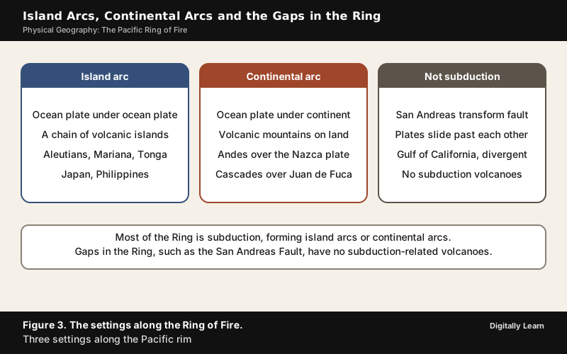
The volcanoes built by subduction take two forms, depending on what the ocean plate sinks under. When oceanic crust sinks beneath other oceanic crust, the volcanoes rise from the sea as a curved chain of islands, an island arc, like the Aleutians, the Marianas or Tonga. When it sinks beneath a continent, the volcanoes rise on land as a continental arc, such as the Andes above the Nazca plate and the Cascades above the Juan de Fuca plate.
The same squeeze explains why great fold mountains stand at the edges of continents. Where the sinking slab dips at a shallow angle, it drags on the plate above and causes crustal thickening, folding, thrust faulting and mountain building. The Rocky Mountains were raised this way when a slab sank at a shallow angle beneath North America. So fold mountains, earthquakes and volcanoes line the same belts, because all three come from plates converging there. Young fold mountains lie in two principal belts, the circum-Pacific and the Alpide, so the Andes and the Rockies belong to the circum-Pacific fold mountain system.
Wadati-Benioff Zone: Why Ring of Fire Earthquakes Are Deep
Earthquakes at a subduction zone do not all happen near the surface. Their foci follow the sinking slab downward and form a sloping band called the Wadati-Benioff zone, which can reach about 670 km deep. Elsewhere on Earth, earthquakes are typically less than 20 km deep.
A world map shows the contrast. Earthquake foci at the mid-ocean ridges are shallow, while along the Alpide belt and the rim of the Pacific the earthquakes are deep-seated. A statement that all Ring of Fire earthquakes are shallow is therefore wrong.
Gaps in the Ring of Fire and the Hawaii Hotspot
The subduction zones round the Pacific do not form a complete ring, and where subduction is absent, so are its volcanoes. The main gaps are these:
- San Andreas Fault: In California the Pacific and North American plates slide past each other along a transform fault about 1,210 km long, the fault behind the 1906 San Francisco earthquake. No plate sinks, so there are no subduction volcanoes; a divergent boundary in the Gulf of California carries the same gap into northern Mexico.
- Andean flat slabs: The Andean Volcanic Belt has four sections, and the gaps between them are thought to come from flat-slab subduction, where the slab sinks at a very shallow angle.
- South Pacific: The Pacific-Antarctic Ridge, the East Pacific Rise and the Chile Ridge pull apart, so the Ring does not close between New Zealand and South America.
Hawaii is not a gap but a point inside the ring. Its volcanoes lie over a hotspot in the middle of the Pacific plate, far from any subduction zone, so it is in the Pacific without being on the Ring of Fire.
Volcanoes, Earthquakes and Tsunamis of the Ring of Fire
Major Volcanoes of the Pacific Ring of Fire
Most of the world's active volcanoes that rise above sea level are in the Ring of Fire, and many are stratovolcanoes, like Mount St Helens, cones built from alternating explosive eruptions of ash and quieter flows of lava. The four largest eruptions of the last 11,700 years all happened in the Ring, and so did 20 of the 25 largest.
| Volcano, country | Key fact |
|---|---|
| Mount St Helens, USA | Cascade arc; the 1980 eruption killed 57 people, the most economically destructive in US history |
| Mount Rainier, USA | Active stratovolcano in the Cascade Range |
| Paricutin, Mexico | Rose from a farmer's cornfield in 1943 |
| Popocatepetl, Mexico | Second-highest peak in Mexico, in the Trans-Mexican Volcanic Belt |
| Cotopaxi, Ecuador | Andean stratovolcano about 50 km south of Quito |
| Ojos del Salado, Chile and Argentina | Highest active volcano in the world, 6,893 m |
| Pinatubo, Philippines | Second-largest eruption of the 20th century, in 1991, rated 6 on the Volcanic Explosivity Index |
| Taal, Philippines | Lake-filled caldera about 50 km south of Manila; 33 recorded eruptions since 1572 |
| Mount Fuji, Japan | Japan's highest and best-known volcano |
| Hunga Tonga-Hunga Ha'apai, Tonga | 2022, the largest eruption since Pinatubo, with a plume 58 km high |
| Ruapehu, New Zealand | One of New Zealand's most active volcanoes |
Not every famous volcano is on the Ring. Mount Etna in Sicily, Italy, sits above the convergent margin between the African and Eurasian plates, far from the Pacific. The 1883 eruption of Krakatoa in the Sunda Strait, which killed at least 36,417 people, happened in western Indonesia, where the Ring and the Alpide belt meet.
Great Earthquakes of the Ring of Fire: Valdivia, Alaska and Tohoku
The strongest earthquake ever recorded, the 1960 Valdivia earthquake in Chile, reached 9.4 to 9.6. Of the five earthquakes of magnitude 9 or more since 1950, all but the 2004 one happened on the Pacific rim.
| Earthquake | Magnitude | Key fact |
|---|---|---|
| 1952, Kamchatka, Russia | 9.0 | Severo-Kurilsk earthquake |
| 1960, Valdivia, Chile | 9.4 to 9.6 | Strongest ever recorded |
| 1964, Alaska, USA | 9.2 to 9.3 | Second most powerful ever recorded |
| 2004, Sumatra-Andaman | 9.2 to 9.3 | Indian Ocean, on the Sunda arc; second or third most powerful |
| 2011, Tohoku, Japan | 9.0 to 9.1 | Tsunami caused the Fukushima nuclear disaster |
The Tohoku earthquake shows how such a quake works. The Pacific plate, sinking beneath northern Honshu at 8 to 9 cm a year, pushed the upper plate down and stored elastic energy until the stress broke the boundary. The break lifted the sea floor by several metres, and that uplift is what sent the tsunami ashore.
How Tsunamis Form at Subduction Zones
A tsunami forms when an earthquake moves the sea floor suddenly and lifts the whole column of water above it. Subduction zones produce the largest tsunamis, because megathrust earthquakes can cause rapid deformation of the sea floor. Eruptions can do it too, as Krakatoa and Hunga Tonga showed. The waves then cross whole oceans.
- 2011, Japan: Waves may have reached 40.5 m at Miyako and ran up to 10 km inland near Sendai, where residents had only eight to ten minutes of warning. Over 3,40,000 people were displaced, and the tsunami caused the Fukushima Daiichi nuclear disaster.
- 2004, Indian Ocean: Set off on the Sunda arc, outside the Ring, the tsunami reached 14 countries, India among them.
- 2022, Tonga: The Hunga Tonga eruption, not an earthquake, sent a tsunami to the coasts of Japan and the Americas.
- 1883, Krakatoa: Most of the 36,417 or more deaths came from the tsunamis that followed the eruption.
Is India on the Ring of Fire? Andaman, Barren Island and the 2004 Tsunami
Is India Part of the Pacific Ring of Fire?
India is not on the Pacific Ring of Fire. Its nearest subduction zone lies in the Indian Ocean, at the Sunda arc, where the Indo-Australian plate sinks beneath the Sunda and Burma plates at 63 to 70 mm a year. The eastern edge of the Indian plate, the northern part of the Indo-Australian plate, runs through the Rakinyoma (Arakan Yoma) mountains of Myanmar to the island arc along the Java Trench.
A chain of volcanoes runs along this boundary from Sumatra to Myanmar, and India's Andaman and Nicobar Islands lie on it. News reports sometimes stretch the Ring of Fire this far, but geologists often place the western Indonesian islands in the Alpide belt instead. India's other great earthquake zone, the Himalayas, is a collision of two continents and also belongs to the Alpide belt.
Barren Island: India's Only Active Volcano
Barren Island, an uninhabited island in the Andaman Sea about 138 km north-east of Port Blair, holds the only confirmed active volcano in the Indian subcontinent.
- 1787: First recorded eruption, followed by eruptions in 1789, 1795, 1803‑04 and 1852.
- 1991: After nearly a century and a half of quiet, an eruption lasting six months.
- 1994‑95 and 2005‑07: Further eruptions; the later one is thought to be linked to the 2004 earthquake.
- 2017‑19: Eruptions seen again, first spotted by the National Institute of Oceanography in January 2017.
- 2025: Mild eruptions in September 2025, the most recent recorded.
The 2004 Sumatra-Andaman Earthquake and Tsunami
On 26 December 2004 a megathrust earthquake of magnitude 9.2 to 9.3 struck about 160 km off the west coast of northern Sumatra. It ruptured the boundary between the Burma plate and the Indian plate, and scientists call it the Sumatra-Andaman earthquake. It was on the Sunda arc of the Indian Ocean, not on the Pacific Ring of Fire.
The tsunami that followed was the largest earthquake-generated tsunami ever recorded. With waves up to 30 m high, it killed an estimated 2,27,898 people in 14 countries, especially in Aceh in Indonesia, Sri Lanka, Tamil Nadu in India and Khao Lak in Thailand.
Previous Year UPSC‑CSE Questions
Each Prelims question is explained option by option, and each Mains question comes with an answer outline.
- UPSC Prelims 2018Consider the following statements :
- The Barren Island volcano is an active volcano located in the Indian territory.
- Barren Island lies about 140 km east of Great Nicobar.
- The last time the Barren Island volcano erupted was in 1991 and it has remained inactive since then.
Which of the statements given above is/are correct ?
How to approach this Prelims question
Approach: Test the location and the eruption history separately. Barren Island is the only confirmed active volcano in Indian territory, so statement 1 holds. It lies about 138 km north-east of Port Blair, not 140 km east of Great Nicobar, so statement 2 fails. It erupted again from 1994 to 1995, from 2005 to 2007, from 2017 to 2019 and in 2025, so statement 3 fails.
Trap to watch: Statement 2 gives a believable distance from the wrong reference point: Barren Island is about 138 km north-east of Port Blair.
Why each option is right or wrong:
- (a) 1 only: Correct. Barren Island is India's only confirmed active volcano.
- (b) 2 and 3: Wrong. Both are false, because the location is wrong and the volcano erupted again after 1991.
- (c) 3 only: Wrong. Statement 3 is false; it has erupted several times since 1991.
- (d) 1 and 3: Wrong. It includes the false statement 3.
Answer: (a) 1 only. Barren Island lies north-east of Port Blair and has erupted several times since 1991.
- UPSC Prelims 2005Where is the volcanic mountain, Mount St. Helens located?
How to approach this Prelims question
Approach: Mount St Helens belongs to the Cascade volcanic arc of the Pacific Northwest of the United States, where its 1980 eruption killed 57 people.
Trap to watch: Japan, the best-known volcanic country of the Ring, tempts option (b).
Why each option is right or wrong:
- (a) Chile: Wrong. Chile is on the Ring of Fire, but Mount St Helens is not there.
- (b) Japan: Wrong. Japan is also on the Ring, but Mount St Helens is not there.
- (c) Philippines: Wrong. The Philippines, home to Taal, are also on the Ring, but Mount St Helens is not there.
- (d) United States of America: Correct. Mount St Helens is in the Cascade arc of the USA.
Answer: (d) United States of America. Mount St Helens stands in the Cascade arc of the United States.
- UPSC Prelims 2000Match List I with List II and select the correct answer using the codes given below the Lists:List I (Oceanic Trench)
- I. Aleutian
- II. Kermadec
- III. Sunda
- IV. S. Sandwich
List II (Location)
- A) Indian Ocean
- B) North Pacific Ocean
- C) South Pacific Ocean
- D) South Atlantic Ocean
Codes:
How to approach this Prelims question
Approach: Place each trench in its ocean. The Aleutian Trench is in the North Pacific (I‑B) and the Kermadec Trench in the South Pacific (II‑C). The Sunda Trench is in the Indian Ocean (III‑A) and the South Sandwich Trench in the South Atlantic (IV‑D). Only one code has all four.
Trap to watch: Sunda is in the Indian Ocean and South Sandwich in the South Atlantic, not the Pacific.
Why each option is right or wrong:
- (a) I‑B, II‑D, III‑A, IV‑C: Wrong. It swaps Kermadec and South Sandwich between the South Pacific and the South Atlantic.
- (b) I‑B, II‑C, III‑A, IV‑D: Correct. The Aleutian is in the North Pacific, the Kermadec in the South Pacific, the Sunda in the Indian Ocean and the South Sandwich in the South Atlantic.
- (c) I‑A, II‑C, III‑B, IV‑D: Wrong. It swaps Aleutian and Sunda.
- (d) I‑A, II‑D, III‑B, IV‑C: Wrong. All four pairs are misplaced.
Answer: (b) I‑B, II‑C, III‑A, IV‑D. The Kermadec lies in the South Pacific and the South Sandwich in the South Atlantic.
- UPSC Prelims 1999Match List I with List II and select the correct answer using the codes given below the Lists:List I (Volcanic Mountain)
- I. Mt. Rainier
- II. Etna
- III. Paricutin
- IV. Taal
List II (Country)
- A. Italy
- B. Mexico
- C. Philippines
- D. USA
Codes:
How to approach this Prelims question
Approach: Match each volcano to its country. Mount Rainier is in the USA (I‑D), Etna in Italy (II‑A), Paricutin in Mexico (III‑B) and Taal in the Philippines (IV‑C). Etna is the one volcano of the four outside the Ring of Fire.
Trap to watch: Option (a) swaps only Etna and Paricutin, so a student unsure of Etna's country picks it.
Why each option is right or wrong:
- (a) I‑D, II‑B, III‑A, IV‑C: Wrong. It swaps Etna and Paricutin between Italy and Mexico.
- (b) I‑D, II‑A, III‑B, IV‑C: Correct. Rainier is in the USA, Etna in Italy, Paricutin in Mexico and Taal in the Philippines.
- (c) I‑B, II‑A, III‑D, IV‑C: Wrong. It swaps Rainier and Paricutin between the USA and Mexico.
- (d) I‑D, II‑C, III‑B, IV‑A: Wrong. It swaps Etna and Taal between Italy and the Philippines.
Answer: (b) I‑D, II‑A, III‑B, IV‑C. Etna is in Italy and Paricutin in Mexico.
- UPSC Mains 2025 GS‑IWhat are Tsunamis? How and where are they formed? What are their consequences? Explain with examples.
Answer outline
The outline sets out what the question asks, the main arguments, relevant examples and the direction of the conclusion; it is not a full model answer.
Introduction: A tsunami is a series of ocean waves set off when an earthquake or an eruption suddenly moves the sea floor and lifts the whole column of water above it.
Body (sub-themes to develop):
- How: A megathrust earthquake lifts the sea floor by several metres, as in Tohoku in 2011; eruptions can do it too, as Krakatoa in 1883 and Hunga Tonga in 2022 showed.
- Where: Subduction zones of the Ring of Fire and the Sunda arc of the Indian Ocean produce the largest tsunamis.
- Consequences: The 2004 tsunami killed an estimated 2,27,898 people in 14 countries, Tamil Nadu among them; the 2011 tsunami displaced over 3,40,000 people and caused the Fukushima Daiichi nuclear disaster.
Conclusion: Tsunamis are born where plates sink, so the coasts that face subduction zones carry the greatest risk.
- UPSC Mains 2020 GS‑IDiscuss the geophysical characteristics of Circum-Pacific Zone.
Answer outline
Introduction: The circum-Pacific belt is a 40,000 km horseshoe of subduction zones round the Pacific Ocean.
Body (sub-themes to develop):
- Tectonics: Oceanic plates (Nazca, Cocos, Juan de Fuca, Pacific, Philippine) subduct at convergent boundaries.
- Relief: Deep trenches such as the Mariana (10,935 m); island arcs (Aleutians, Tonga) and continental arcs (Andes, Cascades).
- Seismicity: About 90 per cent of earthquakes; deep foci in the Wadati-Benioff zone to about 670 km; M9 megathrust events.
- Volcanism: 750 to 915 volcanoes, many explosive stratovolcanoes; andosol soils.
- Gaps: San Andreas transform, Andean flat slabs, divergent south Pacific; Hawaii is a hotspot outside the belt.
Conclusion: One process, subduction, explains all of the belt's features and its hazards.
- UPSC Mains 2014 GS‑IWhy are the world's fold mountain systems located along the margins of continents? Bring out the association between the global distribution of fold mountains and the earthquakes and volcanoes.
Answer outline
Introduction: Fold mountains rise where plates converge, and those boundaries lie along continental margins.
Body (sub-themes to develop):
- Why margins: Ocean-continent subduction and continent collision thicken and fold the crust.
- Circum-Pacific: Andes and Rockies with the Ring's volcanoes and deep earthquakes.
- Alpide belt: Alps and Himalayas, with 17 per cent of the largest earthquakes.
- Contrast: Mid-ocean ridges have shallow quakes and no fold mountains.
Conclusion: Fold mountains, earthquakes and volcanoes are three results of one process, plate convergence.
Sources
- NOAA Ocean Exploration: What is the Ring of Fire?
- NASA Earth Observatory: Plate Tectonics
- USGS Earthquake Catalog: Earthquakes of magnitude 7 or more, 1976 to 2025
- NCERT: Fundamentals of Physical Geography (Class XI), Distribution of Oceans and Continents
- Wikipedia: Ring of Fire
- Wikipedia: Subduction
- Wikipedia: Oceanic trench
- Wikipedia: Mariana Trench
- Wikipedia: Wadati–Benioff zone
- Wikipedia: Volcanic arc
- Wikipedia: Alpide belt
- Wikipedia: 1960 Valdivia earthquake
- Wikipedia: 1964 Alaska earthquake
- Wikipedia: 2011 Tōhoku earthquake and tsunami
- Wikipedia: 2004 Indian Ocean earthquake and tsunami
- Wikipedia: Barren Island (Andaman Islands)
- Wikipedia: Mount St. Helens
- Wikipedia: Mount Pinatubo
- Wikipedia: Krakatoa
- Wikipedia: Hunga Tonga–Hunga Haʻapai
- Wikipedia: San Andreas Fault
- Wikipedia: Sunda Arc
- Wikipedia: Andean Volcanic Belt
- Wikipedia: Cascade Volcanic Arc
- Wikipedia: Taal Volcano
- Wikipedia: Parícutin
- Wikipedia: Mount Rainier
- Wikipedia: Mount Etna
- Wikipedia: Aleutian Trench
- Wikipedia: Kermadec Trench
- Wikipedia: Peru–Chile Trench
- Wikipedia: South Sandwich Trench
- Wikipedia: Hawaiian–Emperor seamount chain
- UPSC: Previous year question papers
Editorial Disclaimer
This article explains the Pacific Ring of Fire for UPSC preparation, drawing on NOAA, NASA, the US Geological Survey and the NCERT geography textbooks. Magnitudes, depths and death tolls follow those sources.


