


Overview
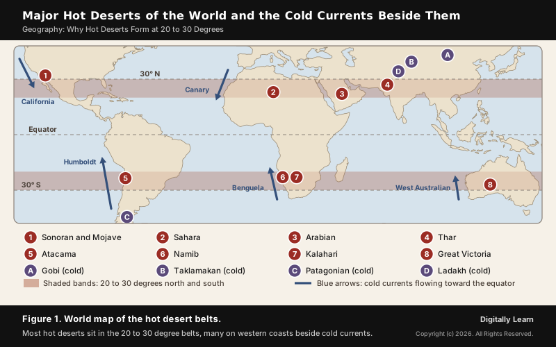
Hot deserts form in two belts between about 20 and 30 degrees north and south of the equator because the air over these latitudes is sinking. Air that rises and rains at the equator flows poleward high in the atmosphere and descends near 30 degrees as part of the Hadley cell. As it sinks it warms and dries, creating the subtropical high pressure belt, where skies stay clear and rain rarely falls. On the western sides of continents, cold ocean currents make the air drier still, which is why the Sahara, the Atacama and the Namib reach right down to the coast.
Hot Deserts of the World: How They Form and Where They Lie
Why Hot Deserts Form at 20 to 30 Degrees Latitude
Major hot deserts in the northern hemisphere lie between 20 and 30 degrees north and on the western side of the continents because the air above them is sinking, and sinking air does not produce rain. The same belt is dry on every continent from Mexico to Australia, which shows that the cause is global rather than local. To see how deserts form here, follow four factors; the first decides the belt and the rest decide how dry each place becomes:
- The subtropical high: Air that rose at the equator sinks near 30 degrees as part of the Hadley cell, warms as it descends and clears the sky of cloud.
- The trade winds: Winds blowing out of the subtropical high toward the equator are stable and dry, and a layer of warm air above them stops tall rain clouds from growing.
- Cold ocean currents: Along western coasts, cold currents cool the air from below, so it gives fog instead of rain.
- Relief and distance from the sea: Mountain barriers cast rain shadows, and the interiors of large continents lie beyond the reach of moist sea winds.
World Deserts Map: Major Hot Deserts of the World
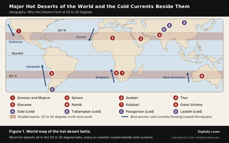
The Sahara is the world's largest hot desert, covering about 9.2 million square kilometres of North Africa. East of it the belt runs through the Arabian Desert into the Thar of India and Pakistan, the easternmost extension of the same Sahara-Arabian desert formation. The map shows how closely the other deserts of the world follow the two shaded belts, and how many sit on western coasts beside a cold current.
| Desert | Where it lies | Main causes of aridity |
|---|---|---|
| Sahara | North Africa, across the Tropic of Cancer | Subtropical high; dry trade winds; cool Canary Current on the Atlantic coast; Atlas Mountains in the north |
| Arabian | Arabian Peninsula, Asia | Subtropical high; continental interior |
| Thar | North-west India and Pakistan | Subtropical high; scanty and variable monsoon rain |
| Sonoran and Mojave | South-west USA and north-west Mexico | Subtropical high; cold California Current; rain shadow of the Sierra Nevada |
| Atacama | Coast of northern Chile, South America | Cold Humboldt Current; South Pacific high; rain shadow on both sides |
| Namib | Coast of Namibia, southern Africa | Cold Benguela Current; subtropical high |
| Kalahari | Botswana, Namibia and South Africa | Subtropical high; interior location |
| Great Victoria | Western and South Australia | Subtropical high; continental interior |
Hadley Cell and the Subtropical High Pressure Belt
Hadley Cell: Rising Air at the Equator, Sinking Air Near 30 Degrees
The Hadley cell is the loop of air that circulates between the equator and about 30 degrees of latitude in each hemisphere. It is named after George Hadley, who proposed it in 1735 to explain the trade winds. The loop works in four steps:
- Rising: Strong heating at the equator makes air rise. As it rises it cools, its water vapour condenses, and heavy rain falls, which is why the equatorial belt carries rainforest.
- Flowing poleward: The risen air, now dry, spreads toward the poles high in the atmosphere.
- Sinking: Near 30 degrees the air descends. It is compressed as it sinks and so warms, and warmer air can hold more moisture, so any cloud evaporates.
- Returning: At the surface the air flows back toward the equator as the trade winds, closing the loop.
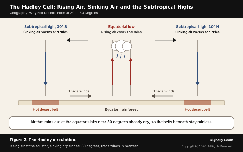
The sinking arm is what makes the deserts. Air reaches the surface near 30 degrees after losing its moisture over the equator, and it keeps warming on the way down. The result is a belt of clear skies, strong sunshine and very little rain.
Subtropical High Pressure Belt, Horse Latitudes and Trade Winds
Where the sinking air reaches the surface it forms the subtropical high pressure belt. These highs are semi-permanent and lie mainly over the oceans between about 20 and 40 degrees of latitude. Sinking air and a temperature inversion, a layer in which temperature rises with height, stop air from rising, so clouds cannot grow tall enough to rain. Fair, dry and hot weather goes with this high pressure band at about 30 degrees, which is why so many deserts line these latitudes around the globe.
Sailors called these calm, dry latitudes around 30 degrees north and south the horse latitudes. Their sunny, still weather under the subtropical ridge is the main reason the world's major hot deserts exist where they do: the Sahara, the Arabian and Syrian deserts, the Mojave and Sonoran in the north, and the Atacama, Namib, Kalahari and Australian deserts in the south.
From the subtropical highs, the trade winds blow toward the equator, from the north-east in the Northern Hemisphere and from the south-east in the Southern. Air sinking from the subtropical ridge above them forms a trade wind inversion, which keeps clouds shallow. Over the desert belt the trade winds therefore carry dust more readily than rain; Saharan dust carried on them sometimes reaches Florida.
Why Hot Deserts Lie on the Western Side of Continents
Cold Ocean Currents, Upwelling and Coastal Fog Deserts
The subtropical highs explain the latitude of the deserts; cold ocean currents explain why the driest of them sit on western coasts. In tropical and subtropical latitudes, the west coasts of continents are bordered by cool water, while warm currents run along the east coasts.
Two processes keep the western waters cold. The currents flow toward the equator from cooler latitudes; the Humboldt and California currents are eastern boundary currents of this kind. Winds blowing from the land toward the sea also drive warm surface water away from the coast, and cold water upwells from below to replace it.
Cold water chills the air just above it. Cool air lying under warmer air is stable and cannot rise, so it forms fog instead of rain. These coasts therefore have low average temperatures, a narrow daily and yearly range, and frequent fog, but almost no rainfall. Five cold currents line the coastal deserts:
- Canary Current: Along Morocco and Western Sahara; it cools the shore and leaves desert coastlines because the cool water suppresses convection.
- California Current: Along the Pacific coast of the USA and Baja California, beside the Sonoran Desert.
- Humboldt (Peru) Current: Along Peru and northern Chile, beside the Atacama.
- Benguela Current: Along Namibia and western South Africa, beside the Namib.
- West Australian Current: A cool current running north along the west coast of Australia.
Why East Coasts at the Same Latitudes Are Wet
The eastern sides of continents at the same latitudes are green. Florida, southern China and eastern Australia lie at much the same latitudes as the Sahara and the Kalahari, yet none of them is a desert. Three differences explain the contrast:
- Warm currents: Warm currents flow along the east coasts in tropical and subtropical latitudes, giving warm and rainy climates.
- Onshore winds: The trade winds blow from the east, so on east coasts they arrive from the sea. Onshore winds also pile warm water against the coast, which raises its temperature further.
- The side of the high: East coasts lie on the western margins of the subtropical anticyclones, where moist tropical air flows in. Weak tropical lows and occasional cyclones add summer rain.
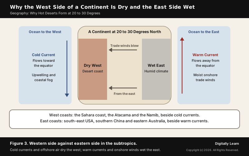
The result is the humid subtropical climate, found on the south-east side of every continent except Antarctica, generally between 25 and 40 degrees. In the middle latitudes the pattern reverses. There the westerlies blow from the west, and the west coasts of continents are bordered by warm water and have a mild marine climate.
Rain Shadow and Continentality: Deserts Beyond the Subtropical Belt
Some deserts owe more to relief than to latitude. When moist air meets a mountain range it is forced up, cools and drops its rain on the windward slope. It then descends the far side, warming and drying as it sinks, and leaves a rain shadow on the leeward side.
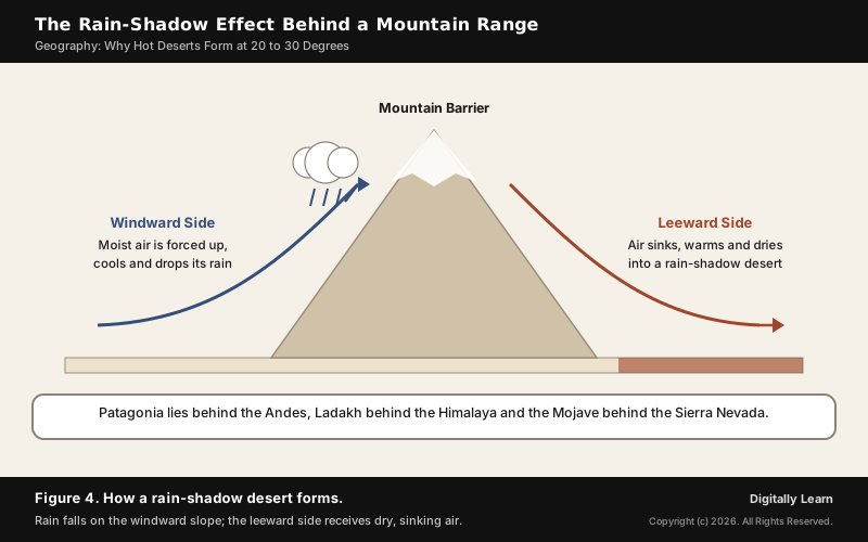
Four deserts show the effect clearly:
- Atacama: The Andes and the Chilean Coast Range block moisture from both the Pacific and the Atlantic, giving a two-sided rain shadow that the cold Humboldt Current and the South Pacific high reinforce.
- Mojave and Great Basin: Both lie in the rain shadow of the Sierra Nevada, which strips Pacific air of its moisture.
- Patagonian Desert: The Andes stop the moist westerlies from the Pacific. Although about half of it lies only some 200 miles from the ocean, it is the largest desert in Argentina.
- Northern Sahara: The Atlas Mountains of Morocco, Algeria and Tunisia add a rain shadow on their leeward side.
Distance from the sea, called continentality, makes the remaining deserts. The Gobi of Mongolia and northern China lies far inland, far to the north and on a plateau roughly 910 to 1,520 metres above sea level, which also makes it cold. The Taklamakan lies in the Tarim Basin of western China and covers about 337,000 square kilometres.
Hot Desert Climate (BWh): Temperature, Rainfall and Life
Hot Desert Climate Characteristics: Heat, Rainfall and Fog
In the Köppen classification a desert climate is one where evaporation far exceeds precipitation. The hot desert climate (BWh) is separated from the cold desert climate (BWk) by a mean annual temperature of 18 °C. BWh is the most extensive of all Köppen climate types, covering about 14.2 per cent of Earth's land area. Its main features are these:
- Scanty, erratic rain: Most deserts receive 25 to 200 millimetres a year. It comes in short, intense thundershowers that run off before they can build soil moisture, and the total varies greatly from year to year.
- Extreme heat: The world’s absolute heat records, above 50 °C, are generally set in hot deserts. The official record is 56.7 °C at Death Valley in the USA, measured on 10 July 1913.
- Cold nights: Clear skies let heat escape quickly after sunset, so night temperatures can fall to freezing or below. Both the daily and the yearly range of temperature are large.
- Near-rainless extremes: Kufra in the Libyan Sahara records about 0.86 millimetres of rain a year.
- Coastal fog: Fog is common in coastal deserts bordering cold currents, even where rain almost never falls.
Desert Plants and Animals: Adaptations to Heat and Drought
Plants that survive long dry periods are called xerophytes. Their adaptations serve one purpose, to lose as little water as possible:
- Leaves: Hard, waxy leaves resist drying. Many desert plants have fewer and smaller leaves or none at all, and in cacti the leaves are reduced to spines.
- Water storage: Cacti store water in thick, rounded stems.
- Roots: Deep, widely spreading roots collect what little water the soil holds.
In the Sahara the vegetation includes cactus, date palms and acacia. Where the wind scoops out a hollow and underground water reaches the surface, an oasis forms, and people settle to grow date palms and other crops. Camels, hyenas, jackals, foxes, scorpions, snakes and lizards are among the animals that live there.
Nomadic groups such as the Bedouins and Tuaregs rear goats, sheep, camels and horses for milk, hides and hair. The discovery of oil in Algeria, Libya and Egypt is now changing the Sahara's economy, and more herders are taking jobs in oil and gas operations.
Hot and Cold Deserts: Differences and Types
Hot Desert vs Cold Desert: Key Differences and Examples
A desert is defined by dryness, not by heat. A cold desert is as dry as a hot one, but its winters are cold. In the Köppen scheme cold deserts have a mean annual temperature below 18 °C, and they lie mainly between 35 and 60 degrees of latitude, in the interiors of continents where moist sea winds do not reach and in areas often surrounded by mountains.
About one-third of Earth's land surface is desert. Deserts may be hot or cold, sandy or rocky, but they are always dry. A widely accepted system by Peveril Meigs (1953) grades dry lands by rainfall: extremely arid land has at least 12 consecutive months without rain, arid land receives less than 250 millimetres a year, and semi-arid land receives 250 to 500 millimetres. Arid and extremely arid lands are deserts; semi-arid grasslands are usually called steppes.
| Basis | Hot deserts (BWh) | Cold deserts (BWk) |
|---|---|---|
| Mean annual temperature | Above 18 °C | Below 18 °C |
| Typical latitude | About 15 to 35 degrees, under the subtropical highs | About 35 to 60 degrees, in continental interiors |
| Main cause | Sinking air of the subtropical high, helped by cold currents | Distance from the sea, rain shadows and high altitude |
| Summers | Very hot | Hot or warm, but less hot than in hot deserts |
| Winters | Mild days, cold nights | Cold and dry |
| Examples | Sahara, Arabian, Thar, Kalahari, Great Victoria | Gobi, Taklamakan, Patagonian, Ladakh |
Deserts can also be grouped by what makes them dry. Five types cover the major deserts of the world:
- Subtropical (trade wind) deserts: Under the subtropical highs; the Sahara, Arabian, Thar, Kalahari and Australian deserts.
- Cold-current coastal deserts: On western coasts beside cold currents; the Atacama and the Namib.
- Rain-shadow deserts: Behind mountain barriers; Patagonia, the Mojave and the Great Basin.
- Interior (continental) deserts: Far from any sea; the Gobi and the Taklamakan.
- Polar deserts: Most of the interior of Antarctica, which receives very little precipitation.
Deserts of India: The Thar and Ladakh
Thar Desert and Ladakh: India's Hot and Cold Deserts
The Thar, or Great Indian Desert, lies in north-western India and Pakistan and is the easternmost extension of the Sahara-Arabian desert formation. It is bordered by the Aravalli Range to the east, the Indus plains to the west and the Rann of Kutch to the south. Its climate is tropical desert, with extremely hot summers and cooler winters.
Unlike the Sahara, the Thar receives monsoon rain in summer, but little of it. Most of its rain comes from the south-west monsoon, and the amount varies widely from year to year, with long spells of drought. Most of western Rajasthan receives less than 50 centimetres of rain a year, and NCERT places extreme western Rajasthan in the hot desert climate. The Luni is the only major river system of the region.
Ladakh is India's cold desert. It lies in the Great Himalayas at heights from about 3,000 metres at Kargil, and in the rain shadow of the Himalaya, so it receives as little as 10 centimetres of rain a year. The air is so thin and dry that a person sitting in the sun with their feet in the shade can suffer sunstroke and frostbite at the same time.
Desertification: How It Differs from Natural Deserts
Desertification: Land Degradation Beyond the Desert Belt
Natural deserts develop over long periods of time through the circulation of the atmosphere. Desertification is different. The UN Convention to Combat Desertification (UNCCD) defines it as land degradation in arid, semi-arid and dry sub-humid regions, resulting from various factors including climatic variations and human activities. Because the definition includes dry sub-humid land, desertification is not confined to the 20 to 30 degree belts. The Convention was established in 1994 and has 197 Parties, 196 countries and the European Union; the United Nations marks the World Day to Combat Desertification and Drought on 17 June.
Its immediate cause is the loss of most of the vegetation, driven by these factors, alone or in combination:
- Drought and climatic shifts
- Tillage for agriculture
- Overgrazing by livestock
- Deforestation for fuel or construction materials
Drylands cover about 40 to 41 per cent of Earth's land area and are home to more than 2 billion people. The areas most affected are the Sahel in Africa, the Gobi and Mongolia in Asia and parts of South America, and the effects include sand and dust storms, food insecurity and poverty. The Sahel lies south of the Sahara and the Gobi is a mid-latitude cold desert, so desertification clearly crosses the boundaries of the hot desert belt.
Hot Deserts in UPSC Previous Year Questions
UPSC Questions on Hot Deserts, Pressure Belts and Currents
UPSC has asked about this topic in both papers. The Mains question of 2013 is the whole topic in one line, and the objective questions test its parts.
| Year and paper | What was asked | The point tested |
|---|---|---|
| 2007 Prelims | Are the horse latitudes low-pressure belts? | No: they are high-pressure belts near 30 degrees |
| 2009 Prelims | Where do tropical deserts occur? | On the western margins of continents within the trade wind belt |
| 2011 Prelims | Why did the African and Eurasian desert belt form? | The subtropical high-pressure cells, not warm currents |
| 2013 Mains, GS Paper I | Why are hot deserts at 20 to 30 degrees north and on western sides? | Subtropical high, trade winds and cold currents |
| 2013 and 2018 Prelims | Leaf modifications of desert plants | Waxy leaves, tiny leaves and thorns all cut water loss |
| 2020 Mains, GS Paper I | Does desertification have climate boundaries? | No: it affects dry sub-humid land as well as deserts |
| 2021 Prelims | Why ocean temperatures differ east to west | Trade winds warm the west of tropical oceans; westerlies warm the east of temperate oceans |
To answer the 2013 Mains question in about 150 words, follow the order of causes in this article:
- Open with the Hadley cell, in which air sinks near 30 degrees and forms the subtropical high.
- Explain why sinking air is dry, since it warms as it descends and the trade wind inversion stops clouds from growing.
- Explain the western location through cold currents such as the Canary and California currents, upwelling, and fog instead of rain.
- Contrast the east coasts, where warm currents and onshore trade winds bring rain.
- Close with examples such as the Sahara, the Arabian, the Thar, and the Sonoran and Mojave deserts.
Previous Year UPSC-CSE Questions
Previous Year UPSC-CSE Questions By the end you will be able to draft model answers for the following UPSC questions. Each question carries a collapsible framework showing how to approach it in the exam.
- UPSC Prelims 2007 Prelims-GSConsider the following statements:
- Either of the two belts over the ocean at about 30°–35° N and S latitudes is known as Horse Latitude.
- Horse Latitudes are low-pressure belts.
Which of the statements given above is/are correct?
How to approach this Prelims question
Approach: Recall what lies under the sinking arm of the Hadley cell near 30 degrees. Sinking air forms the subtropical high pressure belt, and the belts over the ocean at about 30 to 35 degrees north and south are the horse latitudes, so statement 1 holds. Because the air sinks there, they are high-pressure belts, so statement 2 is false.
Trap to watch: Statement 2 calls the horse latitudes low-pressure belts; sinking air makes them high-pressure belts.
Key facts to recall:
- (a) 1 only: right. The horse latitudes are the oceanic belts at about 30 to 35 degrees north and south.
- (b) 2 only: wrong. Statement 2 is false: sinking air makes them high-pressure belts, not low-pressure ones.
- (c) Both 1 and 2: wrong. It includes the false statement 2.
- (d) Neither 1 nor 2: wrong. Statement 1 is true.
Answer signal: Only statement 1 is correct, so option (a) is the answer.
- UPSC Prelims 2009 Prelims-GSConsider the following statements :
- In the world, the tropical deserts occur along the western margins of continents within the trade wind belt.
- In India, the East Himalayan region gets high rainfall from north-east winds.
Which of the statements given above is/are correct ?
How to approach this Prelims question
Approach: Test each statement against the cause of the rain in that region. Tropical deserts occur on the western margins of continents within the trade wind belt, where cold currents and dry, stable air meet: statement 1 holds. The eastern Himalaya is watered by the Bay of Bengal branch of the south-west monsoon moving up the Brahmaputra valley, not by north-east winds: statement 2 is false.
Trap to watch: The eastern Himalaya is watered by the Bay of Bengal branch of the south-west monsoon, not by north-east winds.
Key facts to recall:
- (a) 1 only: right. Tropical deserts lie on the western margins of continents in the trade wind belt.
- (b) 2 only: wrong. The eastern Himalaya's rain comes from the south-west monsoon, not north-east winds.
- (c) Both 1 and 2: wrong. It includes the false statement 2.
- (d) Neither 1 nor 2: wrong. Statement 1 is true.
Answer signal: Only statement 1 is correct, so option (a) is the answer.
- UPSC Prelims 2011 Prelims-GSWhat could be the main reason/reasons for the formation of African and Eurasian desert belt?
- It is located in the sub-tropical high pressure cells.
- It is under the influence of warm ocean currents.
Which of the statements given above is/are correct in this context?
How to approach this Prelims question
Approach: Ask what keeps the African and Eurasian belt dry. It lies under the subtropical high-pressure cells, where sinking air suppresses rain: statement 1 holds. The currents beside it are cold, such as the Canary Current off north-west Africa; warm currents bring rain to east coasts: statement 2 is false.
Trap to watch: Deserts lie beside cold currents, not warm ones; warm currents bring rain to east coasts.
Key facts to recall:
- (a) 1 only: right. The desert belt lies under the subtropical high-pressure cells.
- (b) 2 only: wrong. Deserts lie beside cold currents, not warm ones.
- (c) Both 1 and 2: wrong. It includes the false statement 2.
- (d) Neither 1 nor 2: wrong. Statement 1 is the main reason.
Answer signal: Only statement 1 is correct, so option (a) is the answer.
- UPSC Prelims 2013 Prelims-GSWhich of the following leaf modifications occurs/occur in desert areas to inhibit water loss?
- Hard and waxy leaves
- Tiny leaves or no leaves
- Thorns instead of leaves
Select the correct answer using the codes given below.
How to approach this Prelims question
Approach: Check each leaf feature against the aim of cutting water loss. Hard, waxy leaves resist drying; leaves that are tiny, few or absent lose less water; and in cacti the leaves are reduced to spines, which are thorns in place of leaves. All three are genuine desert adaptations.
Trap to watch: All three are genuine xerophyte adaptations; do not drop thorns as a separate feature.
Key facts to recall:
- (a) 1 and 2 only: wrong. It drops thorns, a separate adaptation seen in cacti.
- (b) 2 only: wrong. It drops waxy leaves and thorns, both real adaptations.
- (c) 1 and 3 only: wrong. It drops tiny or absent leaves.
- (d) 1, 2 and 3: right. All three features cut water loss.
Answer signal: All three modifications occur, so option (d) is the answer.
- UPSC Prelims 2018 Prelims-GSWhich of the following leaf modifications occur(s) in the desert areas to inhibit water loss?
- Hard and waxy leaves
- Tiny leaves
- Thorns instead of leaves Select the correct answer using the code given below:
How to approach this Prelims question
Approach: This repeats the 2013 question with changed option wording. Hard and waxy leaves, tiny leaves and thorns instead of leaves all reduce water loss, so every listed modification counts.
Trap to watch: Option wording changed from 2013; the answer did not.
Key facts to recall:
- (a) 2 and 3 only: wrong. It drops hard and waxy leaves.
- (b) 2 only: wrong. It drops waxy leaves and thorns.
- (c) 3 only: wrong. It keeps only thorns.
- (d) 1, 2 and 3: right. All three are desert adaptations.
Answer signal: All three modifications occur, so option (d) is the answer.
- UPSC Prelims 2021 Prelims-GSConsider the following statements:
- In the tropical zone, the western sections of the oceans are warmer than the eastern sections owing to the influence of trade winds.
- In the temperate zone, westerlies make the eastern sections of oceans warmer than the western sections.
Which of the statements given above is/are correct?
How to approach this Prelims question
Approach: Ask which way the prevailing wind pushes warm surface water in each zone. In the tropics the trade winds blow from the east and pile warm water in the western sections of the oceans: statement 1 holds. In the temperate zone the westerlies blow from the west and pile warm water in the eastern sections: statement 2 holds too. The two look opposite only because the winds blow in opposite directions.
Trap to watch: The two statements look opposite but both are true, because the trade winds and the westerlies blow in opposite directions.
Key facts to recall:
- (a) 1 only: wrong. It leaves out statement 2, which is also true.
- (b) 2 only: wrong. It leaves out statement 1, which is also true.
- (c) Both 1 and 2: right. Trade winds warm the western tropical oceans; westerlies warm the eastern temperate oceans.
- (d) Neither 1 nor 2: wrong. Both statements are true.
Answer signal: Both statements are correct, so option (c) is the answer.
- UPSC Mains 2013 GS-IMajor hot deserts in the northern hemisphere are located between 20-30 degree N and on the western side of the continents. Why?
How to structure the answer in the exam
Introduction: Open with the Hadley cell: air rising at the equator sinks near 30 degrees and forms the subtropical high-pressure belt.
Body (sub-themes to develop):
- Sinking air warms as it descends and the trade wind inversion stops clouds from growing, so the belt is dry.
- Trade winds blow out of the high toward the equator and are dry and stable over land.
- Western side: cold currents such as the Canary and California, with offshore winds and upwelling, give fog instead of rain.
- Contrast: east coasts at the same latitudes have warm currents and onshore winds, so they are wet.
- Examples: the Sahara, Arabian, Thar and the Sonoran and Mojave deserts.
Conclusion: Conclude that the latitude comes from the global circulation, while currents and winds decide the western location.
- UPSC Mains 2020 GS-IThe process of desertification does not have climatic boundaries. Justify with examples.
How to structure the answer in the exam
Introduction: Define desertification in the UNCCD's words: land degradation in arid, semi-arid and dry sub-humid regions from climatic variations and human activities.
Body (sub-themes to develop):
- Natural deserts are set by the global circulation; desertification is degradation of land that need not be desert.
- Causes: loss of vegetation through drought, tillage, overgrazing and deforestation.
- Examples beyond the hot desert belt: the Sahel south of the Sahara, the Gobi and Mongolia, parts of South America.
- Drylands cover about 40 per cent of the land and hold more than 2 billion people.
Conclusion: Conclude that desertification follows land use and rainfall variability, not a latitude belt, so it has no climate boundary.
Sources and Further Reading
- Wikipedia: Hadley cell
- Wikipedia: Horse latitudes
- Wikipedia: Trade winds
- Wikipedia: Desert climate
- Wikipedia: Sahara
- Wikipedia: Thar Desert
- Wikipedia: Atacama Desert
- Wikipedia: Namib
- Wikipedia: Canary Current
- Wikipedia: Humboldt Current
- Wikipedia: Benguela Current
- Wikipedia: California Current
- Wikipedia: West Australian Current
- Wikipedia: Humid subtropical climate
- Wikipedia: Rain shadow
- Wikipedia: Patagonian Desert
- Wikipedia: Gobi Desert
- Wikipedia: Taklamakan Desert
- Wikipedia: Highest temperature recorded on Earth
- Wikipedia: Xerophyte
- Wikipedia: Desertification
- Wikipedia: Ladakh
- NOAA JetStream: Global Atmospheric Circulations
- Deserts: Geology and Resources, What Is a Desert?
- The Convention to Combat Desertification: overview
- World Day to Combat Desertification and Drought
- NCERT: Fundamentals of Physical Geography (Class XI), climate and ocean currents
- NCERT: India Physical Environment (Class XI), climate
- NCERT: Our Environment (Class VII), Life in the Deserts
Editorial Disclaimer
This article explains why the world's hot deserts form at 20-30 degrees latitude, for UPSC preparation, drawing on standard climatology and earth-science sources. Mechanisms and examples reflect the cited authorities. Readers should consult the linked sources for fuller treatment.


