


Overview
Maritime security means keeping a country's ships, ports, coast and sea trade safe from threats at sea such as piracy, maritime terrorism, smuggling, trafficking and illegal fishing. For India it is an economic question as much as a defence one, because nearly 95 per cent of India's trade by volume and about 70 per cent by value moves through its ports. At home it rests on the Navy, the Coast Guard and coastal police; across the Indian Ocean, it rests on shared surveillance, law and diplomacy.
Maritime Security of India: Meaning, Scope and Link to Sea Trade
What Is Maritime Security?
The scope of maritime security is wide. It covers ships and their crews, ports, offshore installations, the coast and the trade that passes along it. The main threats in the Indian Ocean are maritime terrorism, piracy, human and contraband trafficking, illegal and unregulated fishing, arms running and poaching.
Countering these threats starts with knowing what is at sea. The International Maritime Organization (IMO) defines maritime domain awareness as the effective understanding of anything associated with the maritime domain that could affect security, safety, the economy or the environment. Every Indian measure, from coastal radars to the Information Fusion Centre, is a way of building that awareness and acting on it.
Why Maritime Security Is Vital to Protect India's Sea Trade
India's economy runs on the sea. Its foreign trade passes through 12 major and 200 minor ports along a coastline of 11,098.81 km. More than 75 per cent of the world's maritime trade passes through the Indian Ocean Region, as does the oil for half of global consumption, so a threat anywhere on these routes reaches Indian prices and supplies.
| Measure | Figure | Why it matters |
|---|---|---|
| Share of India's trade by sea | About 95% by volume, 70% by value | Sea lanes are India's lifeline |
| Coastline | 11,098.81 km, 13 coastal States and UTs | A long, busy border to watch |
| Exclusive Economic Zone | About 2.3 million sq km | Fish, oil and gas to protect |
| Bab-el-Mandeb | Nearly 10% of global trade | The Red Sea gateway to Europe |
Piracy in the Indian Ocean: Somali Piracy and the High Risk Area
What Is Piracy? UNCLOS Maritime Zones and Indian Law
Sea piracy is a crime of the high seas. India's Maritime Anti-Piracy Act, which gives effect to the United Nations Convention on the Law of the Sea (UNCLOS), defines it as any illegal act of violence, detention or depredation committed for private ends by the crew or passengers of a private ship against another ship, or persons or property on board, on the high seas. It also covers voluntarily taking part in running a pirate ship and inciting or facilitating such acts. Three elements make up the offence:
- Where it applies: The high seas, which the Act defines to include the Exclusive Economic Zone of any state, India's included, and all waters beyond any state's jurisdiction.
- Private ends: The motive is private gain, which separates piracy from acts of states or navies.
- Two ships: Piracy involves one ship attacking another; a crime committed wholly inside one ship is not piracy.
UNCLOS sets out who controls which waters. It came out of a conference held from 1973 to 1982 and came into force on 16 November 1994. A coastal state's rights shrink as one moves away from its baseline, and piracy law applies where no state has full jurisdiction.
| Zone | Width from the baseline | What the coastal state controls |
|---|---|---|
| Territorial sea | Up to 12 nautical miles | Full sovereignty; other ships have innocent passage |
| Contiguous zone | Up to 24 nautical miles | Customs, taxation, immigration and pollution laws |
| Exclusive Economic Zone | Up to 200 nautical miles | Rights over resources such as fish, oil and gas |
| High seas | Beyond national jurisdiction | Open to all; every state may act against pirates |
Somali Piracy: Causes, Peak and Return
Somali piracy grew out of state collapse. After the fall of the Siad Barre government and the civil war that followed, the Somali Navy dissolved around 1991, and foreign trawlers moved into Somali fishing grounds; foreign fishing rose more than twenty-fold after 1981. Coastal groups began by attacking fishing vessels and soon turned to merchant ships in the Gulf of Aden and the wider Indian Ocean. Somali piracy has since passed through three phases:
- Peak: In 2008 there were 111 attacks and 42 successful hijackings; attempted hijackings reached 237 in 2011 before falling to 75 in 2012.
- Decline: Improved anti-piracy measures cut successful attacks from 28 in 2011 to 14 in 2012, and the Indian Ocean High Risk Area was lifted in January 2023.
- Return: In December 2023 pirates made their first successful hijacking of a cargo ship in six years, as instability around the Gaza war spread to the region.
Piracy High Risk Area: From 65 Degrees East to 78 and Back
The High Risk Area is not a legal boundary but an industry advisory marking the zone where merchant ships are told to follow Best Management Practices against piracy, and where insurers charge extra. In 2008 its eastern limit was 65 degrees east, far from India. As piracy spread to the eastern Arabian Sea, the Round Table of international shipping associations extended the limit to 78 degrees east, bringing India's west coast inside it.
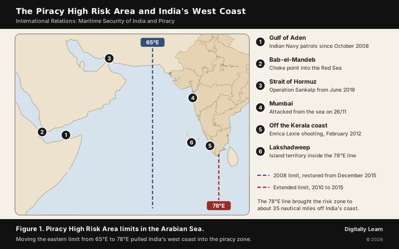
India argued that piracy had ended in its waters, since the last reported attack in the eastern Arabian Sea was in March 2012, and pressed the case at the IMO Council and the Contact Group on Piracy off the Coast of Somalia (CGPCS). On 8 October 2015 the Contact Group announced that the limit would return to 65 degrees east from 1 December 2015.
Impact of the Extended High Risk Area on India's Maritime Security
Pulling the High Risk Area to 78 degrees east turned a distant problem into an Indian one, at four kinds of cost.
- Higher trade costs: About 22,000 ships carrying Indian cargo call at Indian ports each year. The additional war risk premium on them rose to about ₹3,600 crore a year at the peak of piracy and was still about ₹1,500 crore a year afterwards, and it was passed on to consumers through freight.
- Encroachment on the EEZ: The zone came to within about 35 nautical miles of India's baseline, which India called an unwarranted encroachment into its Exclusive Economic Zone.
- Danger to fishermen: Ships hugged the Indian coast to avoid the premium, causing collisions with fishing boats that killed five Indian fishermen, and armed guards on merchant ships fired on Indian fishing boats.
- Floating armouries: Unregulated, foreign-run floating armouries appeared near India's coast, a direct security risk.
The best-known case is the Enrica Lexie incident of 15 February 2012, when two Indian fishermen on the boat St. Antony were killed off Kerala, about 20.5 nautical miles out in India's contiguous zone, allegedly by two Italian marines guarding a tanker. In 2020 the Permanent Court of Arbitration accepted the marines' functional immunity, ruled that the case should continue in Italy, and required compensation for the deaths.
How India Fights Piracy: Navy, Law and Cooperation
Indian Navy Anti-Piracy Operations: Gulf of Aden to MV Ruen
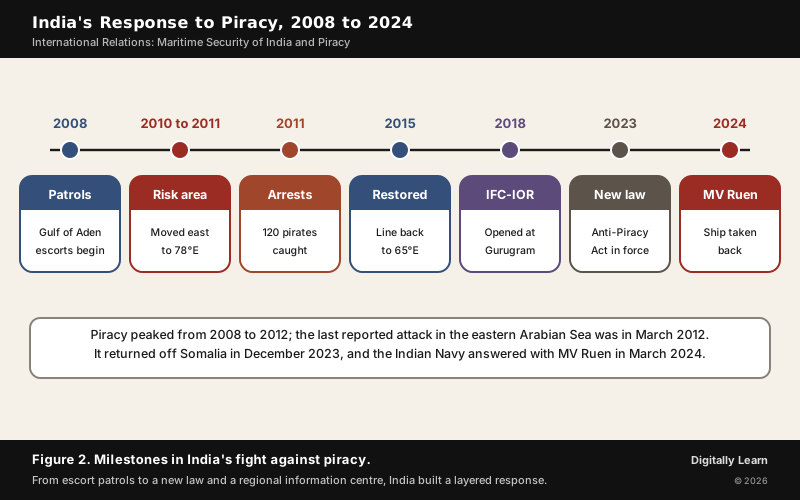
The Indian Navy has kept a warship in the Gulf of Aden on anti-piracy patrol since October 2008. By October 2015 it had deployed 51 ships and escorted more than 3,100 merchant vessels, foreign-flagged ones included, carrying more than 23,000 Indians. Closer to home, the Navy and Coast Guard's Operation Island Watch arrested 120 pirates from four mother ships between January and March 2011. Two operations of 2024 show the Navy acting far from India:
- MV Ruen, March 2024: INS Kolkata intercepted the ship, hijacked in December 2023, about 260 nautical miles east of Somalia and 1,400 nautical miles from India. Supported by INS Subhadra, P-8I surveillance aircraft and marine commandos air-dropped from a C‑17, the Navy forced all 35 pirates to surrender and freed the 17 crew.
- INS Sumitra, January 2024: The patrol vessel freed the fishing vessels Iman, with 17 Iranian crew, and Al Naeemi, with 19 Pakistani crew, from Somali pirates within two days.
At home, an Inter-Ministerial Group of officers handles hostage cases, and the Directorate General of Shipping has issued notices on Best Management Practices, such as a citadel (a secure room in which the crew can lock themselves). Sailing vessels may not go south or west of the line joining Salalah and Male.
Maritime Anti-Piracy Act 2022: What the Law Provides
Parliament passed the Maritime Anti-Piracy Act, 2022, on 20 December 2022, criminalising maritime piracy and empowering the Navy and other agencies to act at sea. The Act (Act No. 3 of 2023) received assent on 31 January 2023 and came into force on 22 February 2023. It gives effect to UNCLOS, which India ratified on 29 June 1995. Its main provisions are these:
- Punishment for piracy: Imprisonment up to life, or fine, or both; death or life imprisonment if the act of piracy causes death or is an attempt to cause death; plus forfeiture of property.
- Attempt, abetment and conspiracy: Imprisonment up to 10 years; organising or directing others to take part in piracy, up to 14 years.
- Powers at sea: Officers of the Navy and Coast Guard and authorised government officers may board a ship suspected of piracy on the high seas, arrest the people on board and seize the ship.
- Trial: Courts of Session, notified as Designated Courts after consulting the Chief Justice of the High Court, try piracy cases so that they are heard quickly.
International Cooperation Against Piracy: CGPCS, CTF‑151 and Atalanta
No navy can police the Indian Ocean alone, so piracy is fought through coalitions. India takes part in the CGPCS, a United Nations initiative, and in 2016 was chosen to co-chair its working group on improving maritime situational awareness at the plenary in Seychelles, attended by more than 60 countries and organisations. Two multinational naval operations work in the same waters:
- Combined Task Force 151: A multinational naval task force set up on 12 January 2009 against piracy in the Gulf of Aden and off Somalia.
- Operation Atalanta: The European Union's first naval operation, launched on 8 December 2008 to protect World Food Programme ships and deter piracy off Somalia.
Maritime and Coastal Security Challenges for India
Maritime Security Challenges: Terrorism, Choke Points and Illegal Activity
The gravest lesson came on 26/11. The attackers of November 2008 sailed from Karachi, hijacked an Indian fishing trawler on the way and killed four of its crew, and landed in South Mumbai in inflatable boats. The attack showed that a long, busy coastline full of fishing boats can be a way in for terrorists. Three other challenges remain:
- Choke points: The Houthi attacks on shipping in the Red Sea since late 2023 threaten the Bab-el-Mandeb, which carries nearly 10 per cent of global trade; India raised surveillance and escorted Indian ships. Earlier, as tension rose in the Gulf region, the Navy launched Operation Sankalp on 19 June 2019 to escort Indian-flagged ships through the Strait of Hormuz; by May 2021, 20 warships had escorted over 200 Indian ships carrying more than 21 million tonnes of cargo.
- Crime at sea: Smuggling, human trafficking, arms running and illegal fishing use the same routes as honest trade.
- Many agencies: Nearly 15 national and State agencies share the watch over 11,098.81 km of coast and an EEZ of about 2.3 million sq km, so coordinating them is itself a challenge, which joint exercises such as Sea Vigil and Sagar Kavach are meant to test.
Coastal Security After 26/11: Sagar Kavach and Sea Vigil
After 26/11 India rebuilt coastal security in layers. At the top, the National Committee for Strengthening Maritime and Coastal Security, headed by the Cabinet Secretary, coordinates all agencies. The Indian Navy is the lead agency for overall maritime security; since February 2009 the Indian Coast Guard has been responsible for coastal security in territorial waters, including areas patrolled by coastal police, and for coordination between central and State agencies. The layers below it are:
- Joint Operations Centres: Four, at Mumbai, Visakhapatnam, Kochi and Port Blair, manned round the clock by the Navy, Coast Guard and marine police.
- Surveillance chain: 74 Automatic Identification System (AIS) receivers and 46 coastal radars, with 38 more radar stations for near gap-free cover.
- One picture: The National Command Control Communication and Intelligence (NC3I) network feeds the Information Management and Analysis Centre (IMAC) at Gurugram, which shares a common operating picture with 51 Navy and Coast Guard nodes.
- Exercises: Sea Vigil, first held in January 2019 along the whole coast and EEZ, and the Coast Guard's regional Sagar Kavach exercises test every agency together.

Maritime Domain Awareness: IFC‑IOR, IPMDA and SAGAR
IFC‑IOR and IPMDA: Maritime Domain Awareness in the Indian Ocean
The Information Fusion Centre for the Indian Ocean Region (IFC‑IOR) extends India's coastal picture to the whole ocean. It was launched on 22 December 2018 at the Information Management and Analysis Centre in Gurugram and is hosted by the Indian Navy. Its task is to work with partner nations and multinational maritime bodies to build shared maritime domain awareness and to share information on vessels of interest. It also works with other information fusion centres, helps build the capacity of smaller navies, and coordinates responses to incidents and disasters.
The Quad of Australia, India, Japan and the United States launched the Indo-Pacific Partnership for Maritime Domain Awareness (IPMDA) at its 2022 summit in Tokyo. It gives partner countries near-real-time radio-frequency data at low cost, so that they can track "dark" vessels that switch off their transponders, counter illegal, unreported and unregulated fishing, respond to disasters and enforce their own laws. Three points decide its value for India:
- How it reaches India's region: The Quad scaled IPMDA through the Pacific Islands Forum Fisheries Agency, partners in Southeast Asia and the IFC‑IOR at Gurugram, helping well over two dozen countries.
- The bridge to SAGAR: By feeding its data through India's own centre, IPMDA links the Quad's Indo-Pacific agenda with India's Indian Ocean vision of helping neighbours watch their own waters.
- The limits: It adds awareness, not ships; small states still need boats, aircraft and trained people to act on what they see, and the data flow depends on sustained cooperation among the four partners.
SAGAR, MAHASAGAR, IONS and IORA
SAGAR (Security and Growth for All in the Region), India's vision for the Indian Ocean, was announced in Mauritius in 2015. In March 2025, again in Mauritius, India widened it into MAHASAGAR, Mutual and Holistic Advancement for Security and Growth Across Regions, covering trade for development, capacity building and mutual security for the Global South. Three regional initiatives work alongside it:
- IOS SAGAR: INS Sunayna sailed as the Indian Ocean Ship SAGAR on 5 April 2025 with 44 naval personnel from nine friendly nations on board.
- Indian Ocean Naval Symposium (IONS): A voluntary forum of the navies of Indian Ocean littoral states; its first meeting was held in 2008 with India as host.
- Indian Ocean Rim Association (IORA): Launched in March 1997, with 23 member states and its secretariat at Ebene, Mauritius; it is mainly about economic cooperation, not a security alliance.
International Maritime Organization: Global Rules for the Sea
IMO's Role in Protecting the Environment and Maritime Safety
The International Maritime Organization is the United Nations specialised agency that regulates shipping. The convention that created it was adopted at a conference in Geneva in 1948 and came into force in 1958, and the IMO first met in January 1959. It has its headquarters in London and 176 member states; its Assembly meets every two years, and a 40-member Council acts in between. Its three core conventions cover safety, the environment and security:
- Safety, SOLAS: Prompted by the sinking of the Titanic, SOLAS 1974 came into force on 25 May 1980 and sets minimum standards for ships' construction, equipment and operation; its parties flag about 99 per cent of merchant tonnage.
- Environment, MARPOL 73/78: In force since 2 October 1983, it limits pollution from ships, including oil, dumping and air pollution.
- Security, the ISPS Code: Agreed in December 2002 after the 11 September 2001 attacks and in force from 1 July 2004, it sets security duties for governments, shipping companies, crews and ports.

Previous Year UPSC‑CSE Questions
Each Prelims question is explained option by option, and each Mains question comes with an answer outline.
- UPSC Prelims 2022With reference to the United Nations Convention on the Law of Sea, consider the following statements:
- A coastal state has the right to establish the breadth of its territorial sea up to a limit not exceeding 12 nautical miles, measured from baseline determined in accordance with the convention.
- Ships of all states, whether coastal or land-locked, enjoy the right of innocent passage through the territorial sea.
- The Exclusive Economic Zone shall not extend beyond 200 nautical miles from the baseline from which the breadth of the territorial sea is measured.
Which of the statements given above are correct?
How to approach this Prelims question
Approach: Test each statement against the limits UNCLOS sets for the maritime zones.
- Statement 1 is correct, since a coastal state may set its territorial sea up to 12 nautical miles.
- Statement 2 is correct, since ships of all states enjoy innocent passage through it.
- Statement 3 is correct, since the EEZ cannot extend beyond 200 nautical miles from the baseline.
Trap to watch: Statement 2 looks too wide, because it gives the right even to land-locked states; UNCLOS does give innocent passage to ships of all states.
Why each option is right or wrong:
- (a) 1 and 2 only: Wrong. Statement 3 is also correct.
- (b) 2 and 3 only: Wrong. Statement 1 is also correct.
- (c) 1 and 3 only: Wrong. Statement 2 is also correct.
- (d) 1, 2 and 3: Correct. All three restate UNCLOS correctly.
Answer: (d) 1, 2 and 3. UNCLOS allows a territorial sea of up to 12 nautical miles, innocent passage for ships of all states and an Exclusive Economic Zone of up to 200 nautical miles.
- UPSC Prelims 2017Consider the following in respect of Indian Ocean Naval Symposium (IONS):
- Inaugural IONS was held in India in 2015 under the chairmanship of the Indian Navy.
- IONS is a voluntary initiative that seeks to increase maritime co-operation among navies of the littoral states of the Indian Ocean Region.
Which of the above statements is/are correct?
How to approach this Prelims question
Approach: Check the year of the first symposium and the nature of the forum.
- Statement 1 is wrong, since the Indian Ocean Naval Symposium began in 2008, not 2015.
- Statement 2 is correct, since it is a voluntary initiative for maritime cooperation among the navies of the Indian Ocean littoral states.
Trap to watch: India hosted the first IONS in 2008, not 2015.
Why each option is right or wrong:
- (a) 1 only: Wrong. IONS began in 2008.
- (b) 2 only: Correct. IONS is a voluntary initiative of littoral navies.
- (c) Both 1 and 2: Wrong. Statement 1 has the wrong year.
- (d) Neither 1 nor 2: Wrong. Statement 2 is correct.
Answer: (b) 2 only. The first symposium was held in 2008, not 2015, and IONS is a voluntary forum of the littoral navies.
- UPSC Prelims 2015With reference to 'Indian Ocean Rim Association for Regional Cooperation (IOR‑ARC)', consider the following statements:
- It was established very recently in response to incidents of piracy and accidents of oil spills.
- It is an alliance meant for maritime security only.
Which of the statements given above is/are correct?
How to approach this Prelims question
Approach: Check when the association was formed and what it was formed for.
- Statement 1 is wrong, since IOR‑ARC was launched in March 1997 and was not a response to piracy and oil spills.
- Statement 2 is wrong, since its focus is trade, investment and economic cooperation, not maritime security alone.
Trap to watch: The association's present name, IORA, makes it sound new; it is the IOR‑ARC of 1997.
Why each option is right or wrong:
- (a) 1 only: Wrong. It dates from 1997 and was not set up over piracy.
- (b) 2 only: Wrong. Its focus is economic cooperation.
- (c) Both 1 and 2: Wrong. Both statements are wrong.
- (d) Neither 1 nor 2: Correct. Both statements misdescribe the association.
Answer: (d) Neither 1 nor 2. IOR‑ARC was launched in 1997 for economic cooperation, not recently and not for maritime security alone.
- UPSC Mains 2026 GS‑II"IPMDA (Indo-Pacific Partnership for Maritime Domain Awareness) bridges the gap between India's SAGAR (Security and Growth for All in the Region) vision and the Quad's collective Indo-Pacific strategy." Make a critical assessment of the statement focusing on IPMDA.
Answer outline
The outline sets out what the question asks, the main arguments, relevant examples and the direction of the conclusion; it is not a full model answer.
Introduction: IPMDA, launched by the Quad at Tokyo in 2022, gives partners near-real-time data to track dark vessels.
Body (sub-themes to develop):
- Bridge: IPMDA data flows through the IFC‑IOR at Gurugram, the hub of India's SAGAR vision.
- Strengths: Helps over two dozen countries watch their EEZs, counter illegal fishing and respond to disasters.
- Limits: Awareness without ships or trained people; depends on sustained cooperation among four partners.
- India's wider frame: SAGAR since 2015, MAHASAGAR since 2025.
Conclusion: IPMDA strengthens SAGAR where India's centre is the hub, but capacity building must follow the data.
- UPSC Mains 2025 GS‑IIIWhy is maritime security vital to protect India's sea trade? Discuss maritime and coastal security challenges and the way forward.
Answer outline
Introduction: Nearly 95 per cent of India's trade by volume and about 70 per cent by value moves through its ports.
Body (sub-themes to develop):
- Why vital: Energy imports through Hormuz, trade through Bab-el-Mandeb, an 11,098.81 km coastline and a 2.3 million sq km EEZ.
- Maritime challenges: Piracy off Somalia, Red Sea attacks, smuggling, trafficking, illegal fishing.
- Coastal challenges: Sea-borne terrorism as on 26/11, many agencies, a busy coast full of fishing boats.
- Measures: Coastal radar chain, JOCs, NC3I and IMAC, Sea Vigil and Sagar Kavach, the Anti-Piracy Act 2022.
Conclusion: The way forward is to complete gap-free surveillance, deepen the IFC‑IOR and IPMDA partnerships, build shipbuilding and naval capacity, and keep SAGAR's cooperative approach.
- UPSC Mains 2023 GS‑II'Sea is an important Component of the Cosmos'. Discuss in the light of the above statement the role of the IMO (International Maritime Organisation) in protecting environment and enhancing maritime safety and security.
Answer outline
Introduction: The IMO is the UN agency that regulates shipping; headquartered in London, it has 176 member states.
Body (sub-themes to develop):
- Environment: MARPOL 73/78 on oil, dumping and air pollution from ships.
- Safety: SOLAS 1974, prompted by the Titanic, on ship construction, equipment and operation.
- Security: The ISPS Code from 2004 for ships and ports; forums on piracy.
- India: Raised the High Risk Area at the IMO Council in 2015.
Conclusion: A healthy, safe and secure sea is a shared global good, which only common rules can protect.
- UPSC Mains 2022 GS‑IIIWhat are the maritime security challenges in India? Discuss the organisational, technical and procedural initiatives taken to improve the maritime security.
Answer outline
Introduction: India's long coastline and trade dependence make maritime security central to national security.
Body (sub-themes to develop):
- Challenges: Sea-borne terrorism, piracy, smuggling, trafficking, illegal fishing, choke points.
- Organisational: The National Committee for Strengthening Maritime and Coastal Security, the Navy as lead agency, Coast Guard for territorial waters, Joint Operations Centres.
- Technical: 46 coastal radars and 74 AIS receivers, NC3I and IMAC, IFC‑IOR.
- Procedural: Exercises such as Sea Vigil and Sagar Kavach, and the Maritime Anti-Piracy Act, 2022.
Conclusion: Coordination among agencies and partners is as important as new equipment.
- UPSC Mains 2014 GS‑IIIIn 2012, the longitudinal marking for high-risk areas for piracy was moved from 65 degrees east to 78 degrees east in the Arabian Sea by the International Maritime Organization. What impact does this have on India's maritime security concerns?
Answer outline
Introduction: The High Risk Area is the shipping industry's piracy advisory zone; its eastern limit moved from 65 to 78 degrees east, reaching India's west coast.
Body (sub-themes to develop):
- Security: Armed guards on ships, floating armouries near the coast, traffic hugging the coast.
- Fishermen: Collisions that killed five, firing by guards, the Enrica Lexie case of February 2012.
- Economy: Additional war risk premium of about ₹3,600 crore a year at the peak on Indian cargo.
- Sovereignty: The zone came within about 35 nautical miles of the baseline, into India's EEZ.
- Response: Navy and Coast Guard operations, no piracy near India after March 2012, diplomacy at the IMO and CGPCS.
Conclusion: India had the line restored to 65 degrees east from 1 December 2015, a case of maritime diplomacy protecting security and trade.
Sources
- PIB (Ministry of Defence): Revision of Piracy High Risk Area, 9 October 2015
- PIB (Ministry of Shipping): Re-drawal of the High Risk Area in the Indian Ocean, 9 October 2015
- PIB: Measures to Prevent Piracy at Sea, 2011
- PIB: Anti-piracy operations against pirate ship MV Ruen, 2024
- PIB: INS Sumitra anti-piracy operation, 2024
- PIB: India co-chairs CGPCS working group on maritime situational awareness, 2016
- PIB: Raksha Mantri inaugurates IFC‑IOR, 2018
- PIB: Exercise Sea Vigil, 2018
- PIB: Coastal security exercise Sagar Kavach‑02/25
- PIB: Ports handle 95 per cent of India's trade by volume, 2026
- PIB: Fact Sheet, 2024 Quad Leaders' Summit (IPMDA)
- PIB: India-Mauritius joint press statement, MAHASAGAR, 2025
- PIB: INS Sunayna flagged off as IOS SAGAR, 2025
- India Code: The Maritime Anti-Piracy Act, 2022
- Indian Navy: Initiatives to strengthen coastal security
- Indian Coast Guard: Coastal Security
- Wikipedia: Piracy off the coast of Somalia
- Wikipedia: Enrica Lexie case
- Wikipedia: Operation Sankalp
- Wikipedia: 2008 Mumbai attacks
- Wikipedia: Red Sea crisis
- Wikipedia: International Maritime Organization
- Wikipedia: SOLAS Convention
- Wikipedia: MARPOL 73/78
- Wikipedia: International Ship and Port Facility Security Code
- Wikipedia: United Nations Convention on the Law of the Sea
- Wikipedia: Exclusive economic zone of India
- Wikipedia: Maritime domain awareness
- Wikipedia: Combined Task Force 151
- Wikipedia: Operation Atalanta
- Wikipedia: Indian Ocean Naval Symposium
- Wikipedia: Indian Ocean Rim Association
- NCERT: India People and Economy (Class XII), Transport and Communication
- NCERT: Contemporary India II (Class X), Lifelines of National Economy
- UPSC: Civil Services Examination question papers
Editorial Disclaimer
This article explains maritime security and piracy from India's anti-piracy law, government releases and the other sources listed. It is not legal advice.
See more of our UPSC articles in Google Search
Add to Preferred Sources

