

Overview
Plate tectonics is the theory that Earth's rigid outer shell is broken into a small number of large plates and some minor ones, which move slowly over a softer layer beneath and so explain where continents, oceans, mountains, earthquakes and volcanoes lie. The theory took shape in 1967, when McKenzie and Parker, and Morgan independently, put together the ideas of continental drift, convection in the mantle and sea-floor spreading. Every major feature of the earth's surface, from the Himalaya to the Mid-Atlantic Ridge, is read through it.
Lithosphere, Plates and the History of the Theory
Lithosphere, Asthenosphere and the Meaning of a Plate
To understand a plate, start with the layers it is made of. The earth has a thin outer crust, a mantle that extends to a depth of 2,900 km and a core beyond that. The crust is about 5 km thick under the oceans and about 30 km under the continents, and it thickens to as much as 70 km under the Himalayan region. The upper part of the mantle is called the asthenosphere; the word means weak, and this zone is the main source of the magma that reaches the surface in volcanic eruptions.
The crust together with the uppermost mantle forms the lithosphere, a rigid shell. A tectonic plate, also called a lithospheric plate, is a massive, irregularly shaped slab of solid rock made of continental lithosphere, oceanic lithosphere or both. Plates move horizontally over the asthenosphere as rigid units. A plate is called continental or oceanic by the type that fills the larger part of it. The Pacific plate is largely oceanic, while the Eurasian plate is largely continental.
Two points follow. First, it is the plate that moves and not the continent, since continents are simply parts of plates. Second, the plate theory corrects Wegener on this exact point, because he had imagined continents ploughing through the ocean floor.
How Plate Tectonics Theory Developed: A Timeline
The theory is the end of a chain of ideas, and the chain is itself a favourite examination topic.
- 1596: Abraham Ortelius, a Dutch map maker, first suggested that the Americas, Europe and Africa were once joined.
- 1912: Alfred Wegener put forward the full argument for continental drift.
- 1930s: Arthur Holmes proposed convection currents in the mantle as a possible force.
- 1950s and after the Second World War: Mapping of the ocean floor revealed mid-oceanic ridges, deep trenches and young rocks.
- 1961: Harry Hess proposed sea-floor spreading.
- 1963: Vine, Matthews and Morley linked magnetic stripes on the sea floor to reversals of the earth's magnetic field.
- 1965: J. Tuzo Wilson added the transform fault, which completed the set of boundary types.
- 1967: McKenzie and Parker, and Morgan, formulated plate tectonics.
Continental Drift Theory of Alfred Wegener
Pangaea, Panthalassa, Laurasia and Gondwanaland
The continental drift theory holds that the continents were once joined in a single landmass and have since moved apart. Wegener, a German meteorologist, set out this argument in 1912, and it dealt with the distribution of the oceans and continents. Continents cover 29 per cent of the earth's surface and the rest is under oceanic water, so the idea that their positions change was a bold claim.
According to Wegener, all the continents formed a single continental mass, which he named Pangaea, meaning all earth. A mega-ocean called Panthalassa, meaning all water, surrounded it. Around 200 million years ago Pangaea began to split. It first broke into two large continental masses, Laurasia in the north and Gondwanaland in the south, and these then continued to break into the smaller continents that exist today.
The idea of fitting continents together was older than Wegener. Ortelius had proposed it as early as 1596, and in 1858 Antonio Snider-Pellegrini drew maps showing how the American and African continents might once have fitted and then separated. What Wegener added was a comprehensive body of evidence. Alexander Du Toit, one of his staunchest supporters, is credited with the proposal that Pangaea first broke into the two landmasses Laurasia and Gondwanaland.
Evidence for Continental Drift Theory
Wegener and later workers offered several kinds of evidence. Each one is worth remembering with its example, because questions are framed around the examples.
- Jigsaw fit: The shorelines of Africa and South America facing each other match remarkably. A computer-produced map by Bullard in 1964 tested the fit of the Atlantic margins at the 1,000-fathom line rather than the present shoreline and found it quite perfect.
- Rocks of the same age: Radiometric dating shows that a belt of ancient rocks of 2,000 million years on the Brazil coast matches rocks in western Africa. The earliest marine deposits along the coastlines of South America and Africa are of Jurassic age, which suggests the Atlantic did not exist before that time.
- Tillite deposits: A tillite is a sedimentary rock formed from glacial deposits. The Gondwana system of sediments in India has counterparts in six landmasses of the Southern Hemisphere, with thick tillite at the base that shows prolonged glaciation. The counterparts lie in Africa, the Falkland Islands, Madagascar, Antarctica and Australia, together with India itself.
- Placer deposits: Rich placer gold occurs on the coast of Ghana, yet there is no source rock there. The gold-bearing veins are in Brazil, so the Ghana deposits must have come from the Brazil plateau when the two continents lay side by side.
Fossil and Climate Evidence for Drift
Fossils gave Wegener what he regarded as the most compelling evidence. Identical species of plants and animals that lived on land or in fresh water are found on either side of marine barriers, and it was physically impossible for most of them to have swum or been carried across the oceans. Mesosaurus was a small reptile adapted to shallow brackish water, and its skeletons are found only in the southern Cape province of South Africa and in the Iraver formations of Brazil, two places now 4,800 km apart with an ocean between them. Lemurs occur in India, Madagascar and Africa, which once led some scientists to imagine a land bridge called Lemuria.
Fossils of the seed plant Glossopteris occur in all the southern continents, including India, where more than 70 fossil species have been recognised. Coal deposits, the remains of tropical plants, occur in Antarctica, which means that frozen land once lay closer to the equator. Glacial deposits occur in present-day arid South Africa, as in the Vaal River valley.
Wegener's Forces and the Reasons for Rejection
Wegener suggested two forces for the movement of the continents, the pole-fleeing force and the tidal force. The pole-fleeing force comes from the earth's rotation. The earth is not a perfect sphere and has a bulge at the equator because of rotation, and Wegener believed the continents were pushed away from the poles towards it. The tidal force comes from the attraction of the moon and the sun, which develops tides in the oceans. He believed these forces would become effective when applied over many millions of years.
Most scholars considered the forces totally inadequate. The scientific community also firmly believed that continents and oceans were permanent features of the earth. A fatal weakness was therefore the question of force. What could move such large masses of solid rock over such distances? Wegener suggested the continents ploughed through the ocean floor, but the English geophysicist Harold Jeffreys argued correctly that a large mass of solid rock could not plough through the ocean floor without breaking up.
Wegener died in 1930 during an expedition across the Greenland ice cap, and the controversy continued. Most of his evidence came from the continents, in the form of fossils, rock deposits and tillite. The answer to the force problem came only after the Second World War, from the ocean floor.
Ocean Floor Evidence and Convection Current Theory
Mapping the Ocean Floor and the Mid-Oceanic Ridge
The decades after the Second World War changed the picture. Expeditions to map the oceanic floor showed that the sea bed is not a vast plain but is full of relief. Four developments pushed the theory forward. These were the demonstration of the ruggedness and youth of the ocean floor, the confirmation of repeated reversals of the earth's magnetic field, the idea of sea-floor spreading with recycling of oceanic crust, and the precise mapping of earthquake and volcanic activity along trenches and submarine mountain ranges.
The ocean floor is divided into three major parts by depth and form of relief, namely continental margins, deep-sea basins and mid-ocean ridges. Continental margins form the transition between the shores and the deep-sea basins and include the continental shelf, the continental slope, the continental rise and the deep-oceanic trenches. The abyssal plains are extensive plains between the margins and the ridges, where sediments from the continents are deposited.
The mid-oceanic ridge is an interconnected chain of submerged mountains and is the longest mountain chain on the earth. It is marked by a central rift system at the crest, a fractionated plateau and a flank zone along its length. The rift at the crest is the zone of intense volcanic activity. The global system is more than 50,000 km long and in places more than 800 km across, and it winds between the continents like the seam on a baseball. About 90 per cent of it lies under the ocean.
Early soundings gave the first clues. In 1855 a chart by Matthew Maury showed underwater mountains in the central Atlantic, and in 1947 seismologists found that the sediment layer on the Atlantic floor was much thinner than expected. Rocks from the ocean crust also proved to be much younger than continental rocks, and rocks equally distant from the crest on either side of a ridge were remarkably similar in age and composition.
Holmes and the Convectional Current Theory
Arthur Holmes discussed the possibility of convection currents operating in the mantle in the 1930s. Radioactive elements cause thermal differences in the mantle, and the heated material rises, spreads, cools and sinks again. Holmes argued that a system of such currents exists throughout the mantle, and he speculated that the circular motion carried the continents along in much the way a conveyor belt carries objects.
This was the first serious attempt to answer the objection about force, the very objection on which contemporaries had rejected drift. At the time most scientists still believed the earth to be a solid, motionless body. Holmes's idea was later to influence the thinking of Harry Hess on sea-floor spreading.
Sea Floor Spreading Hypothesis of Harry Hess
Hess's Hypothesis and the Recycling of Oceanic Crust
Sea-floor spreading is the process by which new oceanic crust is formed at the crest of mid-oceanic ridges and moves away on either side, widening the ocean. It was proposed by Harry Hess in 1961, though the term was first coined by Robert Dietz. It rests on what the mapping of the ocean floor and the study of the magnetism of oceanic rocks revealed after Wegener's time.
Hess argued that constant eruptions at the crest of oceanic ridges rupture the oceanic crust, and new lava wedges into it and pushes the crust on either side, so the ocean floor spreads. Two facts led him further. The oceanic crust is young, and the spreading of one ocean does not cause the shrinking of another. This made him think about the consumption of the crust. He maintained that the sea floor pushed away from the crest sinks down at the oceanic trenches and is consumed there.
Hess reasoned that if crust is being added along ridges, it must be shrinking elsewhere, since the earth has not changed significantly in size. New crust moves away from the ridges in a conveyor-belt motion, and many millions of years later descends into the trenches. In his picture the Atlantic was expanding while the Pacific was shrinking. The ocean basins are thus perpetually recycled, with creation and destruction of oceanic lithosphere going on at the same time.
This explained three puzzles together, namely why the earth does not grow bigger, why the ocean floor carries so little sediment, and why oceanic rocks are much younger than continental ones.
Palaeomagnetism and Magnetic Stripes on the Ocean Floor
Basalt, the iron-rich volcanic rock of the ocean floor, contains the strongly magnetic mineral magnetite. When molten rock cools, the magnetite grains lock in the direction of the earth's magnetic field at that moment. Rocks therefore fall into two groups, those with normal polarity, which match the present field, and those with reversed polarity, which point the opposite way. This study of the ancient magnetic field is called palaeomagnetism.
When ocean-floor magnetism was mapped from the 1950s, it showed a zebra-like pattern of alternating stripes of normal and reversed polarity on either side of the ridge crest. This is magnetic striping. In 1963 Vine and Matthews, and Morley working separately, hypothesised that the stripes were produced by repeated reversals of the earth's magnetic field as new crust formed and moved away from the ridge. Rocks at the crest always carry present-day normal polarity, and the stripes are symmetrical on both sides. The ocean crust is, in effect, a tape recording of the field's history.
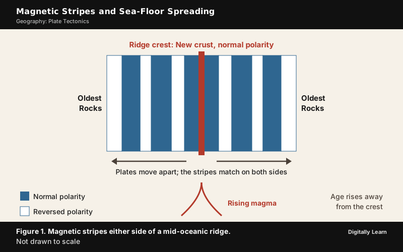
Allan Cox, Richard Doell and Brent Dalrymple of the US Geological Survey dated the reversals of the past 4 million years with the potassium-argon method. In 1966 the known dates matched the stripes on the ocean floor so well that the match became one of the clinching arguments for spreading.
Age of the Ocean Crust and the Proof from Deep-Sea Drilling
Several facts from ocean-floor mapping and palaeomagnetic studies led to the hypothesis. Volcanic eruptions are common all along the ridges. Rocks on either side of the crest match in period of formation, chemical composition and magnetic properties. Rocks closest to the ridge are youngest and have normal polarity, and age increases away from the crest. Ocean-crust rocks are nowhere more than 200 million years old, while some continental rock formations are as old as 3,200 million years. The sediments on the ocean floor are also unexpectedly thin, and nowhere is the sediment column older than 200 million years.
In 1968 the drilling vessel Glomar Challenger criss-crossed the Mid-Atlantic Ridge between South America and Africa and took core samples. Their ages, fixed by fossils and isotopic dating, proved the spreading hypothesis. Parts of the ocean floor dated through the stripes are as old as 180 million years.
Plate Tectonics: Major Plates, Rates and Driving Forces
Seven Major Plates and the Minor Plates
Once spreading and subduction were understood, the idea of rigid moving plates followed. The lithosphere is divided into seven major plates and some minor ones. Young fold mountain ridges, trenches and faults surround the major plates. All plates, without exception, have moved in the geological past and will continue to move.
The seven major plates are the Antarctica plate with the surrounding oceanic plate, the North American plate, the South American plate, the Pacific plate, the India-Australia-New Zealand plate, the Africa plate with the eastern Atlantic floor, and the Eurasia plate with the adjacent oceanic plate. The western Atlantic floor is attached to the North American and South American plates, separated along the Caribbean islands.
| Plate | Where it lies |
|---|---|
| Cocos plate | Between Central America and the Pacific plate |
| Nazca plate | Between South America and the Pacific plate |
| Arabian plate | Mostly the Saudi Arabian landmass |
| Philippine plate | Between the Asiatic and Pacific plates |
| Caroline plate | Between the Philippine and Indian plates, north of New Guinea |
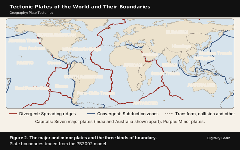
Plate size varies from a few hundred to thousands of kilometres across, and the Pacific and Antarctic plates are among the largest. Thickness varies too. The oceanic lithosphere ranges from 5 to 100 km, and the continental lithosphere is about 200 km. Counting methods differ, since some accounts treat the Indian and Australian plates as separate, so the number of major plates is given as seven or eight depending on how plates are defined.
Rates of Plate Movement
The strips of normal and reversed magnetic field that run parallel to the ridges let scientists work out the rates of plate movement. The rates vary a great deal. The Arctic Ridge has the slowest rate, less than 2.5 cm a year, and the East Pacific Rise near Easter Island, about 3,400 km west of Chile, has the fastest, more than 15 cm a year. Along the Mid-Atlantic Ridge the average is about 2.5 cm a year, or 25 km in a million years. That seems slow, but over 100 to 200 million years it has grown the Atlantic from a tiny inlet between Europe, Africa and the Americas into a vast ocean.
Present-day motion is measured directly by space geodesy, in which very long baseline interferometry, satellite laser ranging and the Global Positioning System fix points on the surface repeatedly. The averages over several years agree well with the averages over millions of years.
Driving Forces: Mantle Convection, Slab Pull and Ridge Push
The slow movement of hot, softened mantle beneath the rigid plates is the driving force of plate movement, and it is believed to move in circles like a pot of thick soup being heated. The heated material rises, spreads, cools and sinks, and this repeated cycle is the convection cell. The details are still debated, and none of the proposed mechanisms explains every aspect of plate movement.
Until the 1990s most scientists stressed mantle convection and spreading at ridges. Intrusion of magma into the ridge was thought to add a force called ridge push. In more recent years, most scientists have favoured subduction. The sinking of a cold, dense oceanic slab into the subduction zone drags the rest of the plate along with it, and this is called slab pull. It is now widely regarded as the strongest force acting on plates. The Pacific plate, which is surrounded by subduction zones, moves much faster than the Atlantic plates, which are attached to continents and not to sinking slabs.
How Plate Movements Reshape Continents and Ocean Basins
Plate movement continually changes the size and shape of oceans and continents, and the same few processes account for all of it. This is the heart of a Mains answer on the subject.
- Where plates move apart at oceanic ridges, an ocean widens. The Atlantic has grown for 100 to 200 million years and is still growing.
- Where an oceanic plate sinks into a trench, the ocean narrows. The trenches ring the Pacific, which is why Hess saw the Pacific as shrinking.
- Where continental crust stretches beyond its limit, a rift forms and can become a new ocean. Spreading has already torn Arabia away from Africa to form the Red Sea, and the East African Rift Zone may be the site of the earth's next major ocean.
- Where two continents meet, an ocean closes and a mountain range rises. The Tethys Sea that separated India from Asia was closed by the collision that built the Himalaya and the Tibetan Plateau.
- Where volcanic activity builds up the sea bed, new land appears, as in the island arcs above subduction zones and the Hawaiian chain over a hotspot.
The opening and closing of ocean basins in this way is described as the Wilson cycle, with the Atlantic as the classic example. The assembly and break-up of supercontinents such as Pangaea is a longer cycle that rarely keeps time with it.
Types of Plate Boundaries: Divergent, Convergent and Transform
Divergent Boundaries and Spreading Centres
Most plate movement is concentrated along narrow zones between plates, where the results of plate-tectonic forces are most visible. There are three types of plate boundaries. A fourth, the plate-boundary zone, is a broad belt where boundaries are not well defined, such as the Mediterranean-Alpine region between the Eurasian and African plates, where several microplates are caught up between the larger ones.
| Boundary type | Plate motion | What happens to crust | Typical features | Examples |
|---|---|---|---|---|
| Divergent | Plates pull apart | New crust is generated | Mid-oceanic ridge, rift valley, shallow earthquakes, basaltic volcanism | Mid-Atlantic Ridge, Iceland, East African Rift |
| Convergent | Plates move toward each other | Crust is destroyed or crumpled | Trench, volcanic arc or fold mountains, deep earthquakes | Andes, Mariana Trench, Himalaya |
| Transform | Plates slide past each other | Crust is neither made nor destroyed | Fault or fracture zone, shallow earthquakes | San Andreas Fault, oceanic fracture zones |
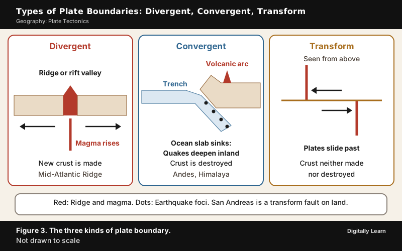
A divergent boundary lies along a spreading centre, where plates move apart and new crust is created as magma pushes up from the mantle. Think of two conveyor belts facing each other and slowly moving in opposite directions, carrying newly formed oceanic crust away from the crest. The best-known example is the Mid-Atlantic Ridge, which separates the American plates from the Eurasian and African plates and extends from the Arctic Ocean to beyond the southern tip of Africa.
Iceland straddles the Mid-Atlantic Ridge and is splitting along the spreading centre between the North American and Eurasian plates. Around Krafla volcano, ground cracks widen and new ones appear every few months; rifting episodes between 1975 and 1984 displaced the ground by about 7 m in all.
On land, a divergent boundary shows up as a rift. In East Africa, spreading has already torn Saudi Arabia away from the rest of Africa and formed the Red Sea. The splitting African and Arabian plates meet at a triple junction, where the Red Sea meets the Gulf of Aden. Tension cracks appear when continental crust stretches, magma rises through them and may erupt as volcanoes. If spreading continues, the three plates meeting at the Horn of Africa may separate completely, letting the Indian Ocean flood the area and making the Horn a large island.
Convergent Boundaries and Subduction Zones
A convergent boundary is a place where plates move toward each other and crust is destroyed as one plate dives under another. The location where a plate sinks is called a subduction zone. Because the earth has not changed in size, crust must be destroyed at about the rate at which it is created. There are three ways in which convergence occurs.
- Oceanic-continental convergence: When an oceanic plate meets a continental plate, the denser oceanic plate is subducted. Off South America, the oceanic Nazca plate is subducted under the continental South American plate along the Peru-Chile trench, and the overriding South American plate is lifted to form the Andes. Trenches are the deepest parts of the ocean floor and are created by subduction; those of the Pacific are thousands of kilometres long and 8 to 10 km deep. Strong earthquakes and rapid uplift are common, and subduction here sustains active volcanoes such as those of the Andes and the Cascade Range.
- Oceanic-oceanic convergence: When two oceanic plates converge, one is usually subducted under the other and a trench forms. The Mariana Trench marks where the fast-moving Pacific plate converges against the slower Philippine plate, and its deepest point, Challenger Deep, plunges nearly 11,000 m. Lava and volcanic debris pile up on the sea floor until a submarine volcano breaks the surface as an island. Such volcanoes are strung out in curved chains called island arcs, which lie close to and parallel to the trench. The Mariana Islands and the Aleutian Islands are examples.
- Continental-continental convergence: When two continents meet head-on, neither is subducted, because continental rock is light and, like two colliding icebergs, resists downward motion. The crust buckles and is pushed upward or sideways. The collision of India with Asia produced the Himalaya and the Tibetan Plateau, and the zone is described further in the Indian plate section below.
The sinking slab produces earthquake zones that dip beneath the trench at 40 to 60 degrees from the horizontal and extend several hundred kilometres into the earth. They are called Wadati-Benioff zones, after the Japanese and American seismologists who recognised them.
Long trenches mark subduction zones in every ocean basin. The Aleutian Trench runs along the southern coast of Alaska and the Aleutian Islands in the North Pacific, the Kermadec Trench lies in the South Pacific, the Sunda Trench lies in the Indian Ocean near Sumatra, and the South Sandwich Trench lies in the South Atlantic.
Transform Boundaries and Fracture Zones
At a transform boundary the crust is neither produced nor destroyed as the plates slide horizontally past each other. The concept of transform faults came from the Canadian geophysicist J. Tuzo Wilson, who proposed that these large faults connect two spreading centres or, less commonly, trenches. Most are on the ocean floor, where they offset the active ridges and give the plate margin a zig-zag form. Earthquakes along them are generally shallow.
Transform faults lie generally at right angles to mid-oceanic ridges. Eruptions do not take place along the whole crest at the same time, so one part of a plate moves differently from the next, and the rotation of the earth also affects the separated blocks.
The San Andreas fault zone in California is one of the few transform faults on land. It connects the East Pacific Rise, a divergent boundary to the south, with the Gorda-Juan de Fuca-Explorer ridge to the north. It is about 1,300 km long, and the Pacific plate has been grinding past the North American plate for 10 million years at an average rate of about 5 cm a year. Oceanic fracture zones are ocean-floor valleys, hundreds to thousands of kilometres long and as much as 8 km deep, that offset the ridges. The offsets in the stripes of magnetic striping show where they were active.
Mantle Plumes and Hotspots: Volcanism Away from Plate Edges
Hotspots and the Hawaiian-Emperor Chain
Most earthquakes and volcanoes occur near plate boundaries, but there are exceptions. The Hawaiian Islands lie in the middle of the Pacific Ocean more than 3,200 km from the nearest plate boundary. Such volcanism in the interior of plates needed a separate explanation.
In 1963 the Canadian geophysicist J. Tuzo Wilson suggested that volcanism stays active for very long periods in certain places because small, long-lasting, exceptionally hot regions lie below the plates. Such a region is called a hotspot. Heat from it partly melts the overriding plate, and the lighter magma rises and erupts on the sea floor, building a seamount that finally grows into an island volcano.
Wilson proposed that the Pacific plate is moving over a deep, stationary hotspot beneath the present position of the island of Hawaii. As plate movement carries an island away from the hotspot, volcanism ceases and a new island forms over the hotspot.
The result is a long trail of volcanic islands and seamounts, the Hawaiian-Emperor chain, whose volcanoes become older and more eroded the farther they are from the hotspot. On the Big Island of Hawaii the oldest exposed rocks are less than 0.7 million years old and new rock is still forming, while the oldest rocks on Kauai are about 5.5 million years old and deeply eroded. The Emperor seamounts at the far end are 39 to 85 million years old. More than a hundred hotspots have been active in the past 10 million years. They sit in three kinds of setting.
- Plate interiors: Most lie under the interiors of plates, such as the African plate.
- Spreading ridges: Some are near ridges, beneath Iceland, the Azores and the Galapagos Islands.
- Continents: Yellowstone is a continental hotspot under the North American plate.
Mantle Plume: Definition, Structure and Role in Plate Tectonics
A mantle plume is a proposed mechanism of convection within the earth's mantle in which super-heated material forms at the core-mantle boundary, at 2,900 km depth, and rises through the mantle. Because the head of the plume partly melts when it reaches shallow depths, a plume is often invoked as the cause of volcanic hotspots such as Hawaii and Iceland and of large igneous provinces such as the Deccan and Siberian Traps. A plume is thought to have a long thin conduit and a bulbous head that expands as it rises, like a mushroom. The idea was first put forward by Wilson in 1963 and developed by Jason Morgan in the early 1970s.
The role of plumes in plate tectonics has four parts.
- Plumes explain intra-plate volcanism, which the boundary processes cannot. Hawaii is the standard case.
- Plumes explain large igneous provinces, huge outpourings of basalt such as the Deccan Traps.
- Hotspot tracks record plate motion. The age-progressive chain of volcanoes shows the direction and speed at which a plate has moved over a source that stays roughly in place.
- Plumes can help to break up continents. Plume-driven weakening of the lithosphere is invoked in rifting, as in the splitting of India from the Seychelles Plateau.
Deccan Traps and the Réunion Hotspot
The Deccan Traps are a large igneous province of west-central India made of many layers of solidified flood basalt, more than about 2 km thick in total, covering about 500,000 square kilometres and having a volume of about 1 million cubic kilometres. They may originally have covered about 1.5 million square kilometres, roughly half the size of modern India. The eruptions took place over 600,000 to 800,000 years between around 66.3 and 65.6 million years ago, spanning the Cretaceous-Paleogene boundary.
The Traps are thought to have been produced in major part by the Réunion hotspot, which is still active and lies under the island of Réunion in the Indian Ocean. As the Indian plate drifted north, the hotspot continued to punch through it, and the Chagos-Laccadive Ridge and the southern Mascarene Plateau are the volcanic traces. A huge eruption about 65 million years ago also opened a rift that separated India from the Seychelles Plateau. Piton de la Fournaise on Réunion is one of the most active volcanoes in the world today.
On the extinction of the dinosaurs, the present consensus is that the Chicxulub asteroid impact was the primary cause and that the Deccan eruptions played a minor role at most. The Traps cover Maharashtra and parts of Gujarat, Karnataka, Madhya Pradesh and Andhra Pradesh. Dykes, the wall-like structures formed when lava cooled in fissures, are common in western Maharashtra and are considered the feeders of the eruptions that built the Traps.
Plate Tectonics in India: The Indian Plate and the Himalaya
The Northward Journey of the Indian Plate
The Indian plate is the most useful example in the syllabus, because it joins plate theory to the physical geography of India. It includes Peninsular India and the Australian continental portion.
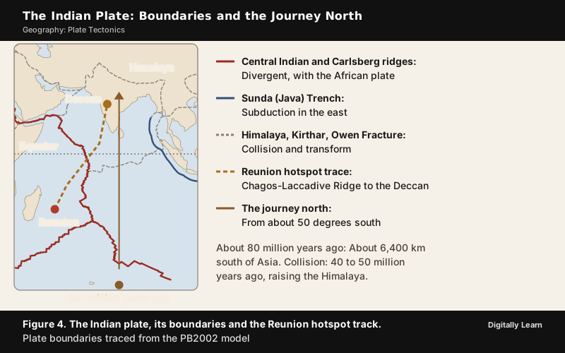
About 225 million years ago India was a large island off the Australian coast, and a vast ocean, the Tethys Sea, separated it from the Asian continent. When Pangaea broke apart about 200 million years ago, India began to move northward. Palaeomagnetic data were used to trace its positions, with the Peninsular rocks analysed from the Nagpur area. About 140 million years ago the subcontinent lay as far south as 50 degrees south latitude.
About 80 million years ago India was roughly 6,400 km south of Asia and moving at about 9 m a century. Another estimate gives about 20 cm a year for the late Cretaceous, faster than any other known plate, though later work questions whether such an acceleration happened. NCERT dates the outpouring of lava that formed the Deccan Traps to around 60 million years ago, when the subcontinent was still close to the equator, while other accounts place the main eruptions between 66.3 and 65.6 million years ago. When India collided with Asia, its northward advance slowed by about half.
Collision with Asia and Formation of the Himalaya
The Himalaya stretch about 2,900 km along the border between India and Tibet. They began to form when the Indian and Eurasian plates collided. Both landmasses have about the same density, so one could not be subducted under the other, and the pressure could only be relieved by thrusting upward. Most of the growth took place in the past 10 million years. The mountains and the Tibetan Plateau, whose average elevation is about 4,600 m, continue to rise by more than 1 cm a year.
The collision is dated to 40 to 50 million years ago, and the formation of the Himalaya proceeds from about 40 million years ago onward. Scientists believe the process is still continuing, and the height of the Himalaya is still rising.
Fossils in pink sandstone fifty kilometres north of Lhasa show that Tibet, at about 105 million years ago, was closer to the equator, with a mild and wet climate. It is now arid, reflecting uplift and a northward shift of nearly 2,000 km.
Indian Plate Boundaries, Himalayan Earthquakes and Barren Island
The Indian plate has all three kinds of boundary. In the north the subduction zone along the Himalaya forms a continent-continent convergence. In the east the boundary runs through the Rakinyoma Mountains of Myanmar towards the island arc along the Java (Sunda) Trench, a trench in the Indian Ocean near Sumatra. The boundary with the Antarctic plate is also an oceanic ridge, running roughly west to east. The western margin follows the Kirthar Mountains of Pakistan and joins the spreading site from the Red Sea rift. A divergent boundary with the African plate lies along the Central Indian Ridge, and a transform boundary with the Arabian plate lies along the Owen Fracture Zone.
The Indian plate moves towards the north and north-east. NCERT gives its speed as one centimetre a year, while other accounts give about 5 cm a year; the Eurasian plate moves north at about 2 cm a year. The movement of the Indian plate is constantly obstructed by the Eurasian plate, so the two plates are locked with each other and energy accumulates. The sudden release of that energy causes earthquakes along the Himalayan arch. The Main Himalayan Thrust absorbs around 20 mm a year of slip, nearly half the total convergence rate. The 1934 Nepal-India (Bihar-Nepal) earthquake of magnitude 8.0 and the 2015 Gorkha earthquake of magnitude 7.8 both occurred on thrust faults of the Himalayan system.
Barren Island in the Andaman Sea is the only confirmed active volcano in the Indian subcontinent and is part of the Andaman and Nicobar Islands. It lies about 138 km north-east of Port Blair, and since its first recorded eruption in 1787 it has erupted more than ten times, most recently in 2025.
Distribution of Earthquakes and Volcanoes
Global Belts: Mid-Ocean Ridge, Alpine-Himalayan and the Pacific Ring of Fire
The maps of earthquakes and volcanoes show three belts. A line of dots follows the mid-oceanic ridges through the central Atlantic into the Indian Ocean, where it divides near the Indian subcontinent into one branch going to East Africa and another meeting a line from Myanmar to New Guinea. A second broad belt follows the Alpine-Himalayan system, and a third follows the rim of the Pacific. The rule is simple. The majority of earthquakes and volcanoes occur where plate boundaries meet.
Along the mid-oceanic ridges, earthquake foci are at shallow depths, and the ridge crest is the zone of intense volcanic activity. The mid-ocean ridge system is the largest single volcanic feature on the earth. Along the Alpine-Himalayan belt and the rim of the Pacific, the earthquakes are deep-seated. The rim of the Pacific is called the Ring of Fire, because of the number of active volcanoes there.
About 90 per cent of the world's earthquakes, including most of the largest, occur in this belt, which is about 40,000 km long. The next most active region, the Alpide belt, extends from central Indonesia to the northern Atlantic through the Himalaya and southern Europe, and has 5 to 6 per cent of earthquakes.
A few places lie outside these belts. The Hawaiian Islands and other hotspot volcanoes are examples, and the central-western parts of India have also had severe earthquakes in Gujarat (1819, 1956 and 2001) and Maharashtra (1967 and 1993), far from the plate edge.
Why Fold Mountains Lie Along Continental Margins
The young fold mountains of the world lie around the plate boundaries, and the connection is direct. Where an oceanic plate is subducted under a continental plate, the overriding continent is lifted along its edge, as the Andes were lifted along the western edge of South America. Where two continents collide, the crust buckles and the mountains rise in the zone between them, as with the Alps and the Himalaya in the Alpine-Himalayan belt. Because convergence takes place at the edges of plates and the continents sit at the edges of oceanic plates, the fold mountains appear along continental margins or across collision zones.
The same boundaries produce the earthquakes and the volcanoes. Subduction creates the volcanic arcs, such as the Andes and the Cascade Range, and the deep earthquakes of the Wadati-Benioff zones. Collision zones such as the Himalaya produce some of the world's most destructive earthquakes. So the belts of fold mountains, earthquakes and volcanoes overlap along the Pacific rim and the Alpine-Himalayan belt.
Earthquake Hazard Zones of India
The most common earthquakes are tectonic, generated by the sliding of rocks along a fault plane. Earthquakes linked to volcanic eruptions, landslides or reservoirs have a limited area of influence. One classification divides India into five earthquake damage-risk zones, from very high to very low, on the basis of an analysis of more than 1,200 past earthquakes by the National Geophysical Laboratory, the Geological Survey of India, the Meteorological Department and the National Institute of Disaster Management.
The Very High Damage Risk Zone includes the North-east states, the area north of Darbhanga and Araria along the Indo-Nepal border in Bihar, Uttarakhand, western Himachal Pradesh, the Kashmir Valley and Kuchchh in Gujarat. The High Damage Risk Zone includes the remaining parts of Jammu and Kashmir, Ladakh and Himachal Pradesh, northern Punjab, eastern Haryana, Delhi, western Uttar Pradesh and northern Bihar. The stable landmass of the Deccan plateau is the safest.
Previous Year UPSC‑CSE Questions
Each question comes with an explanation of how to approach it.
- UPSC Prelims 2025Which of the following are the evidences of the phenomenon of continental drift?
- I. The belt of ancient rocks from Brazil coast matches with those from Western Africa.
- II. The gold deposits of Ghana are derived from the Brazil plateau when the two continents lay side by side.
- III. The Gondwana system of sediments from India is known to have its counterparts in six different landmasses of the Southern Hemisphere.
Select the correct answer using the code given below.
How to approach this Prelims question
Approach: Check each statement against the evidence for drift.
- Statement I: The 2,000-million-year belt of ancient rocks on the Brazil coast matches rocks in western Africa.
- Statement II: The Ghana placer gold has no source rock there, and the gold-bearing veins are in Brazil, so the gold came from the Brazil plateau when the two continents lay side by side.
- Statement III: The Gondwana sediments of India, with thick tillite at the base, have counterparts in six landmasses of the Southern Hemisphere.
All three are evidence.
Trap to watch: Statement II sounds like a mining fact, but it is one of the classic proofs that Africa and South America were joined.
Why each option is right or wrong:
- (a) I and III only: Wrong. Statement II is also evidence: The Ghana gold came from the Brazil plateau.
- (b) I and II only: Wrong. Statement III is also evidence: The Gondwana system has counterparts in six landmasses.
- (c) I, II and III: Correct. The rock belt, the Ghana gold and the Gondwana sediments all support drift.
- (d) II and III only: Wrong. Statement I is also evidence: The Brazil rock belt matches western Africa.
Answer: (c) I, II and III. II and III: Rocks, placer gold and Gondwana sediments are all evidence of drift.
- UPSC Prelims 2008Which of the following pairs is/are correctly matched? Theory/Law - Associated Scientist
- Continental Drift : Edwin Hubble
- Expansion of Universe : Alfred Wegener
- Photoelectric Effect : Albert Einstein
How to approach this Prelims question
Approach: Match each idea with its scientist. Continental drift was put forward by Alfred Wegener, not Edwin Hubble, so pair 1 is wrong. The expansion of the universe is Hubble's work, not Wegener's, so pair 2 is wrong. Einstein explained the photoelectric effect in 1905, so pair 3 is right.
Trap to watch: Pairs 1 and 2 swap the two scientists, and each name looks familiar beside either idea.
Why each option is right or wrong:
- (a) 2 and 3 only: Wrong. Pair 2 is wrong: The expansion of the universe belongs to Hubble.
- (b) 3 only: Correct. Only the photoelectric effect is matched with the right scientist, Einstein.
- (c) 2 only: Wrong. Pair 2 is wrong and pair 3 is right.
- (d) 1 only: Wrong. Pair 1 is wrong: Continental drift belongs to Wegener.
Answer: (b) 3 only. Wegener, not Hubble, proposed continental drift.
- UPSC Prelims 1995The palaeomagnetic results obtained from India indicate that in the past, the Indian land mass has moved
How to approach this Prelims question
Approach: Palaeomagnetism records the latitude at which a rock formed. Peninsular rocks from the Nagpur area place the subcontinent as far south as 50 degrees south about 140 million years ago; it then crossed the Tethys and collided with Asia 40 to 50 million years ago. The movement was northward.
Trap to watch: The plate's present motion is north and north-east, but the recorded shift is from far south to north.
Why each option is right or wrong:
- (a) northward: Correct. India moved from about 50 degrees south to collide with Asia in the north.
- (b) southward: Wrong. India started in the south and moved away from there.
- (c) eastward: Wrong. The palaeomagnetic record shows a change of latitude, a shift from south to north.
- (d) westward: Wrong. The motion was towards the Eurasian plate in the north, not to the west.
Answer: (a) northward. From about 50 degrees south to its present position north of the equator.
- UPSC Prelims 2000Match List I with List II and select the correct answer using the codes given below the Lists:List I (Oceanic Trench)
- I. Aleutian
- II. Kermadec
- III. Sunda
- IV. S. Sandwich
- A) Indian Ocean
- B) North Pacific Ocean
- C) South Pacific Ocean
- D) South Atlantic Ocean
How to approach this Prelims question
Approach: Place each trench. The Aleutian Trench runs along Alaska and the Aleutian Islands in the North Pacific; the Kermadec Trench is in the South Pacific; the Sunda Trench is in the Indian Ocean near Sumatra; the South Sandwich Trench is in the South Atlantic. That gives I‑B, II‑C, III‑A, IV‑D.
Trap to watch: Kermadec and South Sandwich are both southern trenches; one is Pacific and the other Atlantic.
Why each option is right or wrong:
- (a) I‑B, II‑D, III‑A, IV‑C: Wrong. It swaps Kermadec (South Pacific) and South Sandwich (South Atlantic).
- (b) I‑B, II‑C, III‑A, IV‑D: Correct. All four trenches are in the right ocean.
- (c) I‑A, II‑C, III‑B, IV‑D: Wrong. The Aleutian Trench is in the North Pacific and the Sunda Trench in the Indian Ocean.
- (d) I‑A, II‑D, III‑B, IV‑C: Wrong. It misplaces Aleutian and Sunda and swaps Kermadec and South Sandwich.
Answer: (b) I‑B, II‑C, III‑A, IV‑D. Aleutian North Pacific, Kermadec South Pacific, Sunda Indian Ocean, South Sandwich South Atlantic.
- UPSC Prelims 2018Consider the following statements :
- The Barren Island volcano is an active volcano located in the Indian territory.
- Barren Island lies about 140 km east of Great Nicobar.
- The last time the Barren Island volcano erupted was in 1991 and it has remained inactive since then.
Which of the statements given above is/are correct ?
How to approach this Prelims question
Approach: Test each statement.
- Statement 1: Barren Island is the only confirmed active volcano in the Indian subcontinent and part of the Andaman and Nicobar Islands, so it is correct.
- Statement 2: The island lies in the Andaman Sea about 138 km north-east of Port Blair, while Great Nicobar is the southernmost of the Nicobar Islands, far to the south, so the statement is wrong.
- Statement 3: The volcano erupted in 1991 and has erupted again since, most recently in 2025, so it is wrong.
Trap to watch: The 1991 eruption is real; the trap is the claim that the volcano has been quiet since.
Why each option is right or wrong:
- (a) 1 only: Correct. Barren Island is an active volcano in Indian territory; statements 2 and 3 are false.
- (b) 2 and 3: Wrong. Barren Island lies near Port Blair, not beside Great Nicobar, and it has erupted after 1991.
- (c) 3 only: Wrong. The volcano has erupted several times since 1991, most recently in 2025.
- (d) 1 and 3: Wrong. Statement 1 is true but statement 3 is false.
Answer: (a) 1 only. Barren Island is active and Indian, near Port Blair, and erupted again after 1991.
- UPSC Mains 2013 GS‑IWhat do you understand by the theory of 'continental drift'? Discuss the prominent evidences in its support.
Answer outline
The outline sets out what the question asks, the main arguments, relevant examples and the direction of the conclusion; it is not a full model answer.
Introduction: Continental drift is Wegener's theory of 1912 that the continents were once joined in Pangaea and have since moved apart.
Body (sub-themes to develop):
- Fit of coastlines: Africa and South America match at the 1,000-fathom line (Bullard, 1964).
- Rocks and tillite: The Brazil rock belt matches western Africa; Gondwana tillite has counterparts in six landmasses.
- Placer gold: The Ghana gold came from the Brazil plateau.
- Fossils: Mesosaurus only in South Africa and Brazil; Glossopteris across the southern continents.
Conclusion: The theory lacked a convincing force until sea-floor spreading and plate tectonics supplied one.
- UPSC Mains 2018 GS‑IDefine mantle plume and explain its role in plate tectonics.
Answer outline
Introduction: A mantle plume is a column of super-heated material rising from the core-mantle boundary at about 2,900 km depth.
Body (sub-themes to develop):
- Intra-plate volcanism: Hotspots such as Hawaii and Iceland lie away from plate boundaries.
- Record of plate motion: The Hawaiian-Emperor chain grows older away from the hotspot.
- Large igneous provinces: The Deccan Traps are linked to the Reunion hotspot.
- Continental break-up: Plume activity helped separate India from the Seychelles Plateau.
Conclusion: Plumes explain volcanism the boundary processes cannot, though their depth and fixity are still debated.
- UPSC Mains 2014 GS‑IWhy are the world's fold mountain systems located along the margins of continents? Bring out the association between the global distribution of fold mountains and the earthquakes and volcanoes.
Answer outline
Introduction: Fold mountains form where plates converge, and convergence happens at plate edges along continental margins.
Body (sub-themes to develop):
- Ocean-continent convergence: Subduction lifts the overriding edge, as in the Andes.
- Continent-continent collision: The crust buckles, as in the Himalaya and the Alps.
- Earthquakes: Deep along trenches and the Alpine-Himalayan belt, shallow at ridges.
- Volcanoes: Subduction builds volcanic arcs around the Pacific Ring of Fire.
Conclusion: The Pacific rim and the Alpine-Himalayan belt carry fold mountains, earthquakes and volcanoes together.
- UPSC Mains 2025 GS‑IDiscuss how the changes in shape and sizes of continents and ocean basins of the planet take place due to tectonic movements of the crustal masses.
Answer outline
Introduction: The lithosphere is in plates that move over the asthenosphere, driven by mantle convection and slab pull.
Body (sub-themes to develop):
- Widening oceans: Spreading at ridges has grown the Atlantic for 100 to 200 million years.
- Shrinking oceans: Subduction at trenches around the Pacific.
- Splitting continents: The Red Sea and the East African Rift.
- Closing oceans: The Tethys closed and the Himalaya rose.
- New land: Island arcs and hotspot chains such as Hawaii.
Conclusion: The Wilson cycle of opening and closing oceans shows that the map of the world is never fixed.
Sources
- NCERT: Fundamentals of Physical Geography (Class XI), Distribution of Oceans and Continents
- NCERT: Fundamentals of Physical Geography (Class XI), Interior of the Earth
- NCERT: India Physical Environment (Class XI), Structure and Physiography
- NCERT: India Physical Environment (Class XI), Natural Hazards and Disasters
- NCERT: Fundamentals of Human Geography (Class XII), Primary Activities
- USGS: This Dynamic Earth
- USGS: This Dynamic Earth
- USGS: This Dynamic Earth
- USGS: This Dynamic Earth
- USGS: This Dynamic Earth
- USGS: This Dynamic Earth
- USGS: This Dynamic Earth
- USGS: This Dynamic Earth
- NOAA National Ocean Service: The mid-ocean ridge
- NASA Earth Observatory: Putting Earthquakes in Their Place
- Wikipedia: Barren Island (Andaman Islands)
- Wikipedia: Plate tectonics
- Wikipedia: Slab pull
- Wikipedia: Mantle plume
- Wikipedia: Hawaiian–Emperor seamount chain
- Wikipedia: Deccan Traps
- Wikipedia: Réunion hotspot
- Wikipedia: Geology of India
- Wikipedia: Indian Plate
- Wikipedia: Main Himalayan Thrust
- Wikipedia: 1934 Nepal–India earthquake
- Wikipedia: April 2015 Nepal earthquake
- Wikipedia: Wilson cycle
- Wikipedia: Ring of Fire
- Wikipedia: Aleutian Trench
- Wikipedia: Kermadec Trench
- Wikipedia: Sunda Trench
- Wikipedia: South Sandwich Trench
- Wikipedia: Edwin Hubble
- Wikipedia: Photoelectric effect
- Wikipedia: Alfred Wegener
- Wikipedia: Glossopteris
- Wikipedia: Mesosaurus
- Wikipedia: Great Nicobar Island
- UPSC: Civil Services Examination question papers
Editorial Disclaimer
This article uses the current NCERT textbooks and the other sources listed in the Sources section. Where NCERT and other accounts differ on a figure, NCERT's is given first.


