

Overview
The NDMA framework, safe construction and preparedness
Earthquake disaster management in India is the continuous process of planning, organising and carrying out measures before, during and after an earthquake so that deaths, injuries and losses are as small as possible. Because earthquakes can be neither prevented nor predicted, India's system rests on safe buildings, prepared communities and fast response: The Disaster Management Act, 2005, sets up the institutions, the NDMA Guidelines on Management of Earthquakes of April 2007 set the plan of action, and the codes of the Bureau of Indian Standards set the engineering rules.
Why Earthquakes Kill in India: Disaster Cycle and Building Vulnerability
Before and After: Phases of Earthquake Disaster Management
The NDMA guidelines of 2007 divide the work into two halves. Prevention, mitigation and preparedness come before the earthquake. Response, rehabilitation and recovery come after it.
The Disaster Management Act, 2005, moved India from a relief-centric approach to a proactive and integrated one that strengthens preparedness, mitigation and emergency response. Relief after the event is still needed, but most of the effort now goes into reducing what the earthquake can destroy.
Why Collapsing Buildings Cause Most Deaths
The ground shaking itself rarely kills. Past earthquakes show that over 95 per cent of the lives lost were due to the collapse of buildings that were not earthquake-resistant. Similar high-intensity earthquakes in the United States or Japan do not lead to such enormous loss of lives, because the structures there are built with structural mitigation measures and earthquake-resistant features.
Three features of the Indian building stock explain the difference:
- Rural housing: More than 61 per cent of buildings in rural areas are built with mud and clay, stone, brick or concrete without engineering, compared with 26.7 per cent of similar buildings in urban areas.
- Traditional wisdom lost: Bhongas in Kachchh, dhajji diwari in Jammu and Kashmir, brick-nogged wood frames in Himachal Pradesh and ekra construction in Assam are increasingly replaced by reinforced cement concrete buildings that lack earthquake-resistant features.
- Urban growth: Multi-storeyed buildings, super malls and techno parks in metropolitan cities multiply the risk manifold.
About 59 per cent of India's land area is vulnerable to moderate or severe seismic hazard, that is, prone to shaking of MSK intensity VII and above. Between 1990 and 2006, six major earthquakes cost more than 23,000 lives.
Seismic Zones and the Zoning Map in Force
Seismic Zones II to V and the Current Official Map
The Bureau of Indian Standards (BIS) groups India into four seismic zones, II to V, in its code for earthquake-resistant design of structures, IS 1893. Zone V is the most active and Zone II the least. The map now in force is the one published with the 2016 edition of IS 1893.
A newer map was briefly in the news. A Ministry of Earth Sciences reply in Parliament on 17 December 2025 spoke of an updated seismic zonation map that places the entire Himalayan arc in a new highest category, Seismic Zone VI, with only a small portion of Ladakh in Zone V. A Ministry reply of 1 April 2026 then stated that the 2016 map remains the current standard because the revised zonation was withdrawn in March 2026.
Each zone carries a damage-risk class, an intensity on the MSK scale, a design zone factor and a share of India's area. The shares come from the zone map of IS 1893:2002; the 2016 edition kept the same four zones.
| Seismic zone | Damage risk class | Intensity on MSK scale | Zone factor (IS 1893:2002) | Share of India's area |
|---|---|---|---|---|
| V | Very High Damage Risk | IX and above | 0.36 | 10.90 per cent |
| IV | High Damage Risk | VIII | 0.24 | 17.30 per cent |
| III | Moderate Damage Risk | VII | 0.16 | 30.40 per cent |
| II | Low Damage Risk | VI or less | 0.10 | 41.40 per cent |
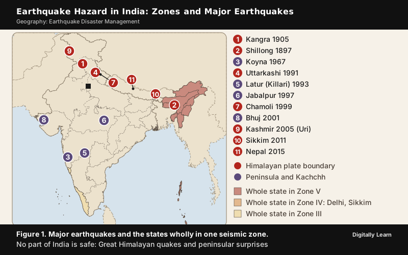
Zones III, IV and V together make up 58.6 per cent of the country, which is where the figure of about 59 per cent comes from. Broadly, Zone V covers the entire north-east, the Kashmir valley, western Himachal Pradesh, the eastern part of Uttarakhand, Kachchh in Gujarat, part of north Bihar and the Andaman and Nicobar Islands. Zone IV includes Ladakh, the remaining parts of Jammu and Kashmir, Himachal Pradesh and Uttarakhand, Delhi, Sikkim and the northern part of Uttar Pradesh. Kerala, Goa and Lakshadweep fall in Zone III.
Delhi lies in Zone IV, where a maximum intensity of VIII on the MSK scale is likely. MSK intensity VIII has actually occurred in Zone IV areas during the 1991 Uttarkashi, 1999 Chamoli and 2001 Bhuj earthquakes, so a Zone IV city cannot treat a small tremor as harmless.
Intensity, Magnitude and Zone Factors in Design
Two different measures are used for an earthquake. Magnitude describes the size of the earthquake and, on the Richter scale, is worked out from the amplitude of the seismic waves recorded by instruments. The scale is logarithmic, so each whole-number rise means a tenfold rise in measured amplitude and about 31.6 times more energy released, not a hundred times. Intensity describes the effects of shaking at a particular place, such as damage to buildings, and is rated on scales such as the Modified Mercalli scale or the Medvedev-Sponheuer-Karnik (MSK) scale. One earthquake has one magnitude but can be rated with different intensities at different places.
The zones are expressed in intensity because that is what a building has to survive. The zone factor is the design value attached to each zone, namely the effective peak ground acceleration the structure should be designed for, from 0.10 in Zone II to 0.36 in Zone V. A school in Zone V is thus designed for much stronger shaking than a school in Zone II.
Major Earthquakes in India and What Each Taught
From Kangra 1905 to Latur 1993
The older Himalayan earthquakes showed how large the hazard is. The entire Himalayan region, along the collision of the Indian and Eurasian plates, is considered vulnerable to earthquakes exceeding magnitude 8.0, and in about 50 years four such events occurred: Shillong 1897 (magnitude 8.7), Kangra 1905 (magnitude 8.0), Bihar-Nepal 1934 (magnitude 8.3) and Assam-Tibet 1950 (magnitude 8.6).
The Kangra earthquake of 4 April 1905 destroyed most buildings in the towns of Kangra, McLeodganj and Dharamshala, and was felt at intensity VII in towns such as Kasauli, Bilaspur, Chamba and Lahore. It is counted among the most catastrophic earthquakes in India's history, with 19,800 lives lost by the official count and more than 20,000 in other accounts. Its magnitude is 8.0 on the scale used in the NDMA guidelines and 7.8 on the surface-wave scale, a difference of method, not of event.
Peninsular India was long thought safe. The Koyna earthquake of 1967 and the Latur earthquake of 1993 dispelled that view and influenced revisions of the seismic zoning map.
The Latur earthquake struck at 3:56 am on 30 September 1993 in the Latur and Dharashiv districts of Maharashtra, far from any plate boundary. It measured 6.2 on the moment magnitude scale with a focus only about 10 km deep, and estimates of the death toll range from 7,582 to over 11,000. In Latur district 817 of 936 villages were affected, and in Killari more than 1,200 people died. The scale of destruction was disproportionate to a moderate magnitude, and poor construction was the main reason. Latur is the standard case of a damaging intraplate earthquake.
Bhuj 2001, Kashmir 2005, Sikkim 2011 and Nepal 2015
The Bhuj earthquake of 26 January 2001 devastated Kachchh in Gujarat. The government gives its magnitude as 7.9 and the United States Geological Survey as 7.7, and the official toll in India is 12,932 lives; counted with Pakistan's Sindh, the deaths reach at least 20,023. Buildings in more than 7,900 villages in 21 districts of Gujarat were damaged, and the economic losses reached beyond the local economy to savings, investment and the stock market.
The Kashmir earthquake of 8 October 2005 had its epicentre near Muzaffarabad in Pakistan-administered Kashmir and measured magnitude 7.6. In India it killed 1,360 people and injured 7,082, with severe damage in the Kupwara and Baramulla districts, where the tehsil of Karnah was almost completely destroyed. Across the region 19,000 students and teachers, most of them in Pakistan, were killed by collapsing schools, which made it a lesson in the safety of public buildings.
The Sikkim earthquake of 18 September 2011 had magnitude 6.9 and a shallow focus about 19.7 km deep, near the Sikkim-Nepal border. At least 75 people were killed in northern India, sixty of them in Sikkim, and in Gangtok many government offices and hospitals were left unusable, a reminder that lifeline buildings must function after the shaking. The Nepal earthquake of 25 April 2015 (magnitude 7.8 to 7.9) caused 78 deaths in India, 58 of them in Bihar, and showed that Indian states can be hurt by an earthquake whose epicentre lies in another country.
| Earthquake | Magnitude | Setting | Lesson for management |
|---|---|---|---|
| Kangra, 4 April 1905 | 8.0 (NDMA) | Himalayan plate boundary | Entire Himalayan region can produce great earthquakes |
| Latur, 30 September 1993 | 6.2 | Peninsular interior | No part of the country is safe; zoning map revised |
| Bhuj, 26 January 2001 | 7.9 (PIB) | Intraplate, Kachchh | Economic losses spread beyond the local economy |
| Kashmir, 8 October 2005 | 7.6 | Himalayan front | Schools and public buildings must be safe |
| Sikkim, 18 September 2011 | 6.9 | Himalayan front | Hospitals and offices must keep working |
| Nepal, 25 April 2015 | 7.8 to 7.9 | Central Himalaya | Cross-border impact reaches Bihar |
Institutional Framework for Earthquake Management
Disaster Management Act, 2005 and Its 2025 Amendment
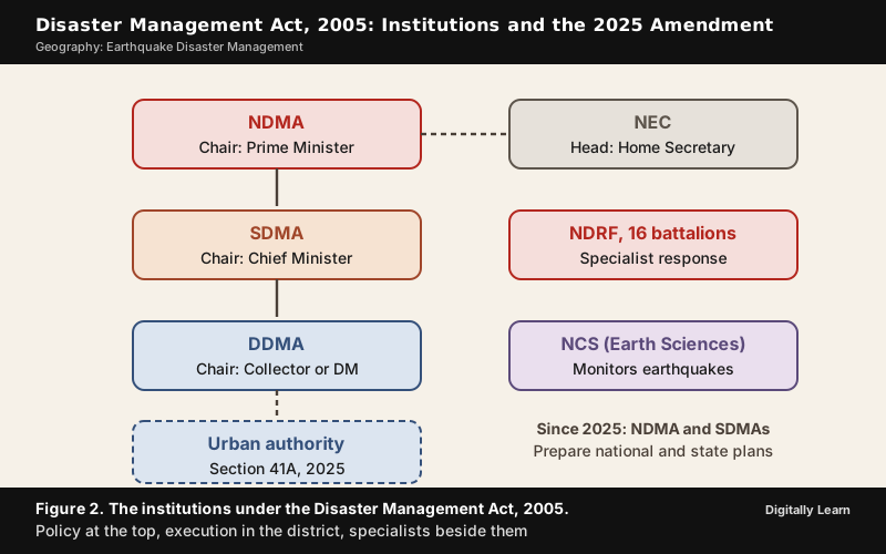
The Disaster Management Act, 2005, received the President's assent on 23 December 2005. It has 11 chapters and 79 sections and extends to the whole of India. It sets up authorities at three levels, national, state and district, with a National Executive Committee to assist the national authority, and they handle every disaster, earthquakes included.
- NDMA: The National Disaster Management Authority, chaired by the Prime Minister, lays down policies, plans and guidelines. It was set up by executive order on 30 May 2005 and constituted under the Act on 27 September 2006.
- SDMA: The State Disaster Management Authority, set up under Section 14 and chaired by the Chief Minister, lays down the state's disaster management policy and plan.
- DDMA: The District Disaster Management Authority is chaired by the Collector or District Magistrate, with the elected representative of the area as co-chairperson.
- NEC: The National Executive Committee, headed by the Home Secretary, assists the NDMA and coordinates the work of ministries.
The Disaster Management (Amendment) Act, 2025, received assent on 29 March 2025, and its provisions came into force on 9 April 2025. It changes the framework in several ways:
- Plans: The NDMA and the SDMAs now prepare the disaster plan at national and state level, a task earlier done by the National Executive Committee and the State Executive Committee.
- Statutory status: The National Crisis Management Committee and the High Level Committee, which existed before the Act, become statutory bodies.
- Database: A disaster database is created at national and state level.
- Urban authority: Section 41A lets states set up an Urban Disaster Management Authority for the state capital and every city with a Municipal Corporation, except Delhi and Chandigarh. As of February 2026 only Karnataka had constituted one, for Bengaluru.
- State forces: States get an enabling provision to constitute a State Disaster Response Force.
NDRF, NIDM and the National Centre for Seismology
Three specialist bodies do the technical work. The NDRF and the NIDM work under the Act, and the National Centre for Seismology works under the Ministry of Earth Sciences. Sections 44 and 45 of the Act provide for the National Disaster Response Force (NDRF), a specialist response force. It was established in 2006 and operates under the NDMA and the Ministry of Home Affairs. The NDRF has 16 battalions, each with a total strength of approximately 1,149 drawn on deputation from the central armed police forces, and each can provide 18 self-contained specialist search and rescue teams of 45 personnel. State Disaster Response Forces are the state counterpart, and NDRF battalions also train SDRF personnel.
The National Institute of Disaster Management (NIDM) is the training and research body; the NDMA guidelines assign it a role in building the capacity of professionals.
The National Centre for Seismology (NCS) under the Ministry of Earth Sciences is the nodal agency for installing, operating and maintaining the National Seismological Network, which had 170 observatories in April 2026. Earthquake monitoring in India began in 1898 with an observatory at Alipore, Kolkata, set up after the great Shillong earthquake of 1897. The Seismology Division and Earthquake Risk Evaluation Centre of the India Meteorological Department merged with NCS in August 2014.
BIS Codes and the Techno-Legal Regime
The engineering rules come from the Bureau of Indian Standards. The NDMA guidelines list the codes that govern earthquake-resistant design and construction:
| Code | What it covers |
|---|---|
| IS 1893, general part | General criteria and building provisions, including the seismic zone map |
| IS 1893, further sections | Liquid retaining structures, bridges and retaining walls, industrial and stack-like structures, dams and embankments |
| IS 4326 | Earthquake-resistant construction of buildings |
| IS 13920 | Ductile detailing of reinforced concrete structures |
| IS 13827 | Earthen dwellings |
| IS 13828 | Low-strength masonry structures |
| IS 13935 | Seismic strengthening of structures |
A code has force only when it is enforced, so the guidelines pair the codes with a techno-legal regime of bye-laws, zoning, compliance review and licensing, and a techno-financial regime of loans and insurance tied to seismic safety.
NDMA Guidelines on Management of Earthquakes
Vision, Mission and Two Phases of Implementation
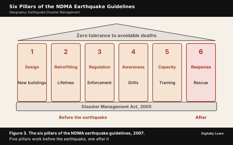
The National Disaster Management Authority issued the National Disaster Management Guidelines: Management of Earthquakes in April 2007. The vision is "Zero Tolerance to avoidable deaths due to earthquakes". The mission is to prepare guidelines for plans that reduce earthquake risk and minimise loss of lives and damage to property.
The guidelines were built from consultations in New Delhi, Kanpur and Mumbai and name seven critical areas of concern, among them lack of awareness of seismic risk, weak enforcement of codes and town planning bye-laws, absence of licensing for engineers and masons, no earthquake-resistant features in non-engineered rural construction, and inadequate preparedness and response capacity. Implementation was planned in two phases, with Phase II beginning on 1 January 2010 to intensify the activities of Phase I.
The Six Pillars of Earthquake Management
The six pillars are the heart of the guidelines:
- Earthquake-resistant design and construction of new structures: All new buildings follow the codes, professionals are certified through licensing, and every design passes a compliance review.
- Selective seismic strengthening and retrofitting of existing priority and lifeline structures: Structural safety audits of lifeline buildings such as hospitals and schools are followed by selective strengthening.
- Regulation and enforcement: The techno-legal and techno-financial regimes bring the codes into force in towns, cities and villages.
- Awareness and preparedness: Mock drills, public campaigns and demonstration projects teach what to do before and during an earthquake.
- Capacity development: Education, training, research and documentation, including earthquake engineering in colleges and training of masons and engineers.
- Emergency response: Trained teams from community level to national level, supported by an Incident Command System and a network of Emergency Operations Centres.
The Techno-Legal and Techno-Financial Regimes
The second and third pillars depend on rules that are actually applied. Under the techno-legal regime, compliance with the codes was to be mandatory with immediate effect in towns and cities in Zones III, IV and V. The designs of all structures go through a mandatory compliance review by the professionals of urban local bodies and panchayati raj institutions, and major projects get a detailed audit by accredited external agencies. Self-certification by the professionals involved is part of building plan approval.
The techno-financial regime fills a gap in how disasters are paid for. After an earthquake the central and state governments provide funds for relief and rehabilitation, but not enough for reconstruction, especially of privately owned buildings. The guidelines therefore ask the insurance sector to promote risk transfer, ask financial institutions to consider seismic safety compliance before offering housing loans, and link the approval of funds for industrial units to compliance with earthquake safety norms.
Earthquake-Resistant Construction
How to Build Earthquake-Resistant Buildings in India
Earthquake-resistant construction accepts that a strong earthquake may damage a building but must not let it collapse. The IS code follows a dual philosophy. Under an extreme earthquake the structure should not collapse. Under more frequent earthquakes it should suffer only minor or moderate damage.
Seismic design is carried out by understanding the possible failure modes of a structure and providing appropriate strength, stiffness, ductility and configuration so that those failures cannot occur. Ductility is the ability to bend and deform without breaking; a ductile building absorbs the energy of shaking in its joints instead of cracking suddenly.
Masonry houses, reinforced concrete buildings and important structures each need their own safety measures:
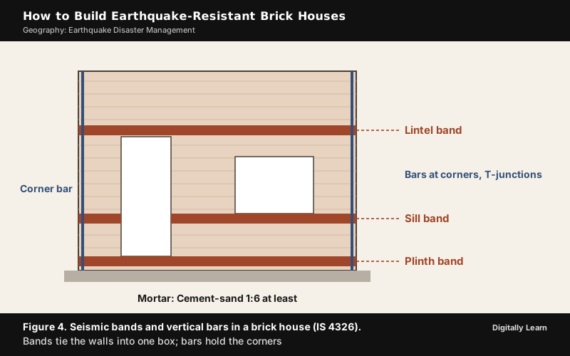
- Seismic bands in masonry: The most important safety elements are horizontal seismic bands at the plinth level and at the lintel level of doors and windows in all external and internal walls. They make the four walls of each room act together as one box. Where the walls need more strength a band at window sill level is added.
- Vertical bars: Vertical reinforcing bars are placed at every corner and T-junction of rooms, running from the foundation through all storeys into the top roof slab.
- Ductile detailing: IS 13920 is the code for ductile detailing of reinforced concrete structures. To prevent catastrophic collapse in earth shaking, a traditional reinforced concrete frame should have ductile joints.
- Shear walls: A shear wall resists lateral forces in the plane of the wall. Typically made of reinforced concrete, reinforced masonry or steel plates, it stiffens a building against sideways seismic load and carries it down to the foundation.
- Base isolation: Rubber or sliding bearings are placed between the building and its foundation so that the structure is substantially decoupled from the shaking ground. It does not make a building earthquake proof, and the NDMA guidelines suggest it for new hospital buildings.
- Light materials and land use: The guidelines advise earthquake-resistant designs and light materials, and discourage high-rise buildings, large industries and big urban centres in vulnerable areas.
Buildings that had both horizontal seismic bands and vertical reinforcing bars as per IS 4326 did not suffer heavy damage or destruction in actual earthquakes; cracking, if any, was very minor.
Rural, Traditional and Non-Engineered Housing
Rural and semi-urban areas account for most of India's building stock, and their construction is largely unregulated. The guidelines do not ask villagers to copy city buildings. They ask state governments to issue illustrative guidelines for each non-engineered construction type, and to build panchayat offices, post offices, primary schools and primary health centres as demonstration buildings. Simple, affordable solutions using indigenous knowledge and local materials, such as the bhonga and the dhajji diwari, should be revived instead of replaced.
For ordinary brick houses a few checks decide safety. These are the number of storeys, the thickness of load-bearing walls, the strength of mortar (cement-sand 1:6 is the minimum recommended, while lime-surkhi is weaker), the width of openings compared with wall length, the presence of horizontal seismic bands, and vertical bars at room corners. A house in Zone V built in Gujarat after 2001 with single-storey one-brick walls in 1:4 cement-sand mortar, seismic bands at plinth, sill and lintel level and vertical corner bars is the model for what a safe village house looks like.
Seismic Retrofitting of Existing Buildings
Seismic retrofitting means structural modification that upgrades the strength, ductility and energy-dissipating ability of seismically deficient or earthquake-damaged structures. The guidelines accept that it is neither practical nor financially viable to strengthen all existing structures in moderate and high seismic risk zones.
They therefore ask for a selective approach. A structural safety audit of existing lifeline structures and other critical structures in earthquake-prone areas comes first. A quick first check is Rapid Visual Screening, in which a trained evaluator judges a building's vulnerability by walking around it. Strengthening then starts with lifeline buildings such as hospitals and schools, as pilot projects and in a phased programme.
Simple retrofitting suits brick houses. Ferro-cement plating fixes a galvanised mesh to the wall and covers it with cement-sand mortar in the ratio 1:3, and seismic belts are added on both faces of the walls where bands were not provided during construction.
Preparedness, Early Warning and Risk Mapping
Monitoring and Seismic Microzonation
Preparedness starts with knowing where the risk is. Seismic observatories grew from 80 in 2014 to 168 by February 2025 and to 170 by April 2026, with broadband seismographs and strong motion accelerographs. The NCS locates and reports events of magnitude 3.0 and above, and its mobile app BhooKamp gives real-time earthquake information.
Seismic microzonation turns these data into planning. It divides a city into zones of least to most damage-prone ground, using geological, geomorphological and land-use maps, drilling and geophysical studies, so that town planners can decide where and how to build. By 2015 it had been completed for cities including Jabalpur, Guwahati, Bengaluru, greater Bharuch, Jammu, Shillong and Chennai, and for Sikkim.
Early Warning, Awareness and the Limits of Prediction
No scientific technique available anywhere in the world can precisely predict earthquakes in terms of time, location and magnitude. The official position in April 2026 is that no proven system exists in the country to provide early earthquake warning. What exists is rapid information. Soon after an earthquake the NCS reports its location, time and magnitude, and publishes an intensity map showing how the shaking varies from the epicentre outwards, sent through its website, app, SMS, e-mail and social media.
Early warning research is moving in the Himalaya. The NCS has begun a real-time seismic network dedicated to early warning, including 10 P-Alert instruments in the Himachal Himalayas, and is testing prototype algorithms for P‑wave detection, rapid magnitude estimation and early shaking prediction. In Uttarakhand, IIT Roorkee and the state government have introduced the BhuDEV app, which delivers real-time earthquake warnings to smartphones and carries an SOS button.
Awareness and training are the soft side of preparedness. NDMA aired a discussion programme on earthquakes called Aapda Ka Samna on Doordarshan in March 2025. The guidelines call for mock drills, campaigns, earthquake topics in school and college curricula, and a campaign of training the trainers among artisans, teachers and practising professionals to meet the shortage of trained people. Engineering education itself had paid little attention to structural mitigation, and licensing of engineers and masons did not exist.
Response, Recovery and Global Frameworks
Search, Rescue and Recovery
The first responder after any disaster is the community. Experience shows that over 80 per cent of search and rescue from collapsed buildings is carried out by the local community before the state machinery and the specialised teams arrive. The guidelines therefore ask for trained community-level search and rescue teams in each district.
The response then widens in steps. Severity is often underestimated immediately after an earthquake, so a rapid, honest assessment of the damage is part of the plan. Depending on the magnitude, the scale of response and the role players are identified at district, state or national level. The primary responsibility for rescue, relief and rehabilitation rests with the State Governments, and the Central Government supplements their efforts with the NDRF where needed. An Incident Command System coordinates the agencies, and a network of Emergency Operations Centres supports the response.
The National Disaster Management Plan, released on 1 June 2016, lists eighteen broad response activities, from early warning, evacuation and search and rescue to medical care, shelter, relief logistics and data collection. India also uses its capacity abroad: NDRF teams, medical personnel and relief went to Turkiye and Syria after the earthquake of February 2023.
After the rescue come rehabilitation and reconstruction. The Sendai Framework asks countries to "Build Back Better" in recovery, rehabilitation and reconstruction, so that rebuilt towns are safer than before. In India the guidelines point to the techno-financial regime as the way to fund reconstruction of private houses, and the National Disaster Management Plan provides a generalised framework for recovery that offers flexibility to assess a situation and build back better.
Hyogo and Sendai Frameworks and India's Alignment
The Sendai Framework for Disaster Risk Reduction (2015 to 2030) was adopted in March 2015 at the World Conference on Disaster Risk Reduction in Sendai, Japan, and endorsed by the UN General Assembly in June 2015. It succeeds the Hyogo Framework for Action (2005 to 2015).
| Feature | Hyogo Framework (2005 to 2015) | Sendai Framework (2015 to 2030) |
|---|---|---|
| Priorities for action | Five, beginning with making disaster risk reduction a priority and ending with strengthening preparedness for response | Four, running from understanding disaster risk and strengthening its governance to investing in resilience and enhancing preparedness to Build Back Better |
| Targets | No global targets; its successor was asked to have achievable targets | Seven global targets, such as lower disaster mortality by 2030 |
| Emphasis | Reducing disaster losses | Disaster risk reduction, with global targets and Build Back Better |
India's own measures follow the same order. Before Sendai came the Disaster Management Act, 2005, and the NDMA earthquake guidelines of 2007. After Sendai came the National Disaster Management Plan of 2016, which is aligned broadly with the goals and priorities of the framework and incorporates its four priorities under five thematic areas for action, from understanding risk to capacity development. India also proposed the Coalition for Disaster Resilient Infrastructure, launched by the Prime Minister at the United Nations Climate Action Summit in New York on 23 September 2019.
Gaps and the Way Forward
Gaps in India's Earthquake Preparedness and Recent Developments
The framework is strong on paper, and the gaps are about application:
- Weak enforcement: India has earthquake-resistant building codes and town planning bye-laws, but they are not strictly enforced.
- Non-engineered housing: Most buildings in rural areas are non-engineered, and retrofitting all of them is not affordable.
- Urban exposure: Large construction in metropolitan cities keeps adding to the risk, and new constructions often overlook strict compliance.
- Human resources: Masons and engineers lack formal training in earthquake-resistant construction, and the licensing of engineers was only proposed.
- Early warning: No proven early warning system covers the country; research in the Himalaya is at an early stage.
- Urban authorities: Only one state, Karnataka, had set up an Urban Disaster Management Authority by February 2026.
The guidelines answer these gaps with compliance review to enforce the codes, audit and retrofitting of lifeline buildings first, licensing and training of engineers and masons, and regular drills.
Reports that earthquakes have become more frequent need care. India recorded 159 earthquakes from November 2024 to February 2025, but the number of seismic observatories also rose from 80 in 2014 to 168 by February 2025, and a denser network records more of the small tremors. Worldwide, many more earthquakes are reported than in the past because instruments have improved, not because earthquakes have become more frequent, and the yearly average of major earthquakes since 1900 has stayed relatively stable. The rising count is therefore a reason to prepare, not proof that the hazard itself has grown.
Previous Year UPSC‑CSE Questions
Each Prelims question is explained option by option, and each Mains question comes with an answer outline.
- UPSC Prelims 2001Consider the following statements regarding earthquakes:
- I. The intensity of an earthquake is measured on the Mercalli scale.
- II. The magnitude of an earthquake is a measure of energy released.
- III. Earthquake magnitudes are based on direct measurements of the amplitude of seismic waves.
- IV. In the Richter scale, each whole number demonstrates a hundred-fold increase in the amount of energy released.
Which of these statements are correct?
How to approach this Prelims question
Approach: Test each statement against the two measures. Intensity describes the effects of shaking at a place and is rated on scales such as the Modified Mercalli scale, so statement I is correct. Magnitude describes the size of the earthquake and is approximately related to the released seismic energy, so statement II is correct. Magnitude is worked out from the amplitude of seismic waves recorded by instruments, so statement III is correct. The scale is logarithmic and one whole number means about 31.6 times more energy, not a hundred times, so statement IV is wrong. Statements I, II and III are right.
Trap to watch: Taking each whole number on the Richter scale as a hundredfold rise in energy; it is about 31.6 times.
Why each option is right or wrong:
- (a) I, II and III: Correct. Statements I, II and III are true, and the false statement IV is left out.
- (b) II, III and IV: Wrong. It includes statement IV, which is false because a whole-number rise releases about 31.6 times more energy, not 100 times.
- (c) I and IV: Wrong. Statement IV is false, and the option also leaves out the correct statements II and III.
- (d) I and III: Wrong. Both are correct, but statement II on energy is also correct and is left out.
Answer: (a) I, II and III. Each whole number of magnitude means about 31.6 times more energy, not a hundred times, so statement IV fails.
- UPSC Mains 2021 GS‑IIIDiscuss about the vulnerability of India to earthquake related hazards. Give examples including the salient features of major disasters caused by earthquakes in different parts of India during the last three decades.
Answer outline
The outline sets out what the question asks, the main arguments, relevant examples and the direction of the conclusion; it is not a full model answer.
Introduction: About 59 per cent of the land is vulnerable to moderate or severe seismic hazard; Zones III, IV and V make up 58.6 per cent of the area.
Body (sub-themes to develop):
- Vulnerability: Himalayan plate boundary can produce earthquakes above magnitude 8.0; intraplate earthquakes in the peninsula and Kachchh; over 61 per cent of rural buildings non-engineered; urban growth adds exposure.
- Examples: Latur 1993 (moment magnitude 6.2, 817 of 936 villages affected in Latur district); Bhuj 2001 (damage in more than 7,900 villages in 21 districts, economic losses beyond the local economy); Kashmir 2005 (1,360 deaths in India, collapsing schools); Sikkim 2011 (at least 75 deaths in northern India); Nepal 2015 (78 deaths in India).
- Lesson: Casualties came primarily from collapse of buildings.
Conclusion: Safe construction and enforcement are the answer.
- UPSC Mains 2020 GS‑IIIDiscuss the recent measures initiated in disaster management by the Government of India departing from the earlier reactive approach.
Answer outline
Introduction: The Disaster Management Act, 2005, began the shift from a relief-centric approach to a proactive and integrated one.
Body (sub-themes to develop):
- Measures: NDMA guidelines with five of six pillars before the earthquake; the National Disaster Management Plan of 2016 covering prevention, mitigation, response and recovery; microzonation of cities; techno-legal and techno-financial regimes; expansion of seismic observatories; the Coalition for Disaster Resilient Infrastructure (2019); the 2025 amendment with a national disaster database, Urban Disaster Management Authorities and statutory status for the High Level Committee.
Conclusion: Prevention and preparedness now take as much attention as relief.
- UPSC Mains 2018 GS‑IIIDescribe various measures taken in India for Disaster Risk Reduction (DRR) before and after signing 'Sendai Framework for DRR (2015–2030)'. How is this framework different from 'Hyogo Framework for Action, 2005'?
Answer outline
Introduction: Sendai (2015 to 2030) succeeded Hyogo (2005 to 2015).
Body (sub-themes to develop):
- Before Sendai: Disaster Management Act, 2005, with NDMA, SDMAs and DDMAs; NDRF set up in 2006; NDMA earthquake guidelines of 2007.
- After Sendai: National Disaster Management Plan of 2016 aligned with the four Sendai priorities; the Coalition for Disaster Resilient Infrastructure launched on 23 September 2019; the Disaster Management (Amendment) Act, 2025.
- Difference: Five Hyogo priorities against four Sendai priorities; Sendai has seven global targets; Build Back Better; emphasis on reducing risk rather than losses.
Conclusion: Sendai moves the focus from managing disasters to reducing risk.
- UPSC Mains 2015 GS‑IIIThe frequency of earthquakes appears to have increased in the Indian subcontinent. However, India's preparedness for mitigating their impact has significant gaps. Discuss various aspects.
Answer outline
Introduction: About 59 per cent of India's land is vulnerable to moderate or severe shaking, and six major earthquakes between 1990 and 2006 cost over 23,000 lives. The apparent rise in frequency reflects a denser network, which grew from 80 observatories in 2014 to 168 by February 2025, so more earthquakes are recorded without the hazard itself having grown.
Body (sub-themes to develop):
- Gaps: Codes and bye-laws exist but are not strictly enforced; rural buildings are largely non-engineered (over 61 per cent against 26.7 per cent in urban areas); retrofitting everything is unaffordable, hence lifeline audits; masons and engineers lack training and licensing; no proven early warning; urban exposure keeps rising.
- Measures: Techno-legal and techno-financial regimes, microzonation, drills, NDRF and community teams.
Conclusion: The NDMA vision of zero tolerance to avoidable deaths calls for safe buildings, since prediction is not possible.
- UPSC Mains 2013 GS‑IIIHow important are vulnerability and risk assessment for pre-disaster management? As an administrator, what are key areas that you would focus on in Disaster Management System.
Answer outline
Introduction: Risk is the expected loss of lives, injuries, damage and disruption, and it grows with vulnerability and exposure even when the hazard is fixed.
Body (sub-themes to develop):
- Importance: Assessment shows which buildings and areas are weakest, so scarce money goes to lifeline structures first; microzonation guides land use and building design; Rapid Visual Screening judges building vulnerability.
- Key areas for an administrator: Compliance review and enforcement of codes and bye-laws; structural safety audit and selective retrofitting of schools and hospitals; training of masons and engineers; mock drills and awareness; trained community teams, since over 80 per cent of rescue is by the community; Emergency Operations Centre and Incident Command System at district level through the DDMA.
Conclusion: Assessment turns disaster management from reactive to preventive.
Sources
- NCERT: Class 11 India: Physical Environment, Chapter 6
- NDMA: National Disaster Management Guidelines, Management of Earthquakes (April 2007)
- PIB (Ministry of Earth Sciences): Making India More Disaster-Resilient, 21 March 2025
- PIB (Ministry of Earth Sciences): Parliament Question, High-Risk Seismic Categorisation of the Himalayan Region, 17 December 2025
- PIB (Ministry of Earth Sciences): Parliament Question, Seismograph Network, 1 April 2026
- PIB (Ministry of Earth Sciences): Parliament Question, Early Warning System, 1 April 2026
- PIB (Ministry of Earth Sciences): Earthquake Prone Zone, 25 February 2015
- PIB (Ministry of Earth Sciences): Research on Earthquakes, 5 February 2021
- PIB (Ministry of Home Affairs): Disaster Management (Amendment) Act, 2025, 22 July 2025
- PIB (Ministry of Home Affairs): Disaster Management (Amendment) Act, 2025, 11 February 2026
- PIB (Ministry of Home Affairs): Highlights of the National Disaster Management Plan, 1 June 2016
- PIB (PMO): PM releases National Disaster Management Plan, 1 June 2016
- PIB: BhuDEV, Transforming Earthquake Preparedness, 24 May 2024
- NIDM: Self Assessment of Earthquake Damageability of Residential Brick Buildings
- NIDM: Simple Retrofitting Details for Improving Earthquake Resistance of Brick Masonry Buildings
- Wikipedia: Earthquake zones of India
- Wikipedia: Disaster Management Act, 2005
- Wikipedia: National Disaster Response Force
- Wikipedia: National Disaster Management Authority (India)
- Wikipedia: National Centre for Seismology
- Wikipedia: Sendai Framework for Disaster Risk Reduction
- Wikipedia: World Conference on Disaster Risk Reduction
- Wikipedia: Coalition for Disaster Resilient Infrastructure
- Wikipedia: 1905 Kangra earthquake
- Wikipedia: 1993 Latur earthquake
- Wikipedia: 2001 Gujarat earthquake
- Wikipedia: 2005 Kashmir earthquake
- Wikipedia: 2011 Sikkim earthquake
- Wikipedia: April 2015 Nepal earthquake
- Wikipedia: Richter scale
- Wikipedia: Earthquake
- Wikipedia: Seismic magnitude scales
- Wikipedia: Earthquake engineering
- Wikipedia: Seismic base isolation
- Wikipedia: Shear wall
- UPSC: Civil Services Examination question papers
Editorial Disclaimer
This article draws on the NDMA earthquake guidelines, releases of the Press Information Bureau, the NIDM, the current NCERT textbook and Wikipedia. Figures are as the official sources give them.
See more of our UPSC articles in Google Search
Add to Preferred Sources