

Overview
The fundamental concepts of geomorphology explain why the earth's surface looks the way it does and how it keeps changing. Geomorphology is the scientific study of the origin and evolution of topographic and bathymetric features, the forms of the land and of the sea floor, generated by physical, chemical or biological processes operating at or near the earth's surface. The word joins the Greek ge (earth), morphe (form) and logos (study).
Geomorphology: Landform, Landscape and Scope
Scope and Branches of Geomorphology
Geomorphologists try to understand why landscapes look the way they do, to understand the history and dynamics of landforms and terrain and to predict how they will change. They do this through field observation, physical experiments and numerical modelling.
The basic unit of the subject is the landform, a small to medium tract or parcel of the earth's surface. Several related landforms together make up a landscape, a large tract of the surface. Each landform has its own shape, size and materials, and each is the result of certain geomorphic processes and agents.
The surface of the earth is modified by surface processes, the action of water, wind, ice, wildfire and life together with the chemical reactions that form soils, and by geologic processes such as tectonic uplift and subsidence. The surface is therefore an intersection of climatic, hydrologic and biologic action with geologic processes. This is why geomorphologists work within physical geography, geology, geodesy, engineering geology, archaeology, climatology and geotechnical engineering.
The subject divides into branches, each following one agent or one question.
- Fluvial geomorphology: The work of rivers, how they transport sediment, migrate across the landscape and cut into bedrock.
- Glacial geomorphology: Glacial deposits such as moraines and eskers, and the erosional features that moving ice leaves behind.
- Aeolian geomorphology: The work of wind, which matters most in arid environments such as deserts.
- Hillslope studies: How hillslopes form and change.
- Soil geomorphology: What soil profiles and chemistry reveal about the history of a landscape.
- Planetary geomorphology: The landforms of other terrestrial planets such as Mars, studied with Earth analogues.
From the middle of the twentieth century the subject became quantitative, with direct field measurement, laboratory studies and full landscape evolution modelling. Terrain is now measured with differential GPS, remotely sensed digital terrain models and laser scanning. The practical uses include hazard assessment such as landslide prediction and mitigation, river control and stream restoration, and coastal protection.
Fundamental Concepts of Geomorphology
Uniformitarianism: The Present Is the Key to the Past
The first fundamental concept is uniformitarianism, the assumption that the natural laws and processes working today have always worked in the past. In geology it is summed up in the phrase "the present is the key to the past". The idea began in the late eighteenth century with the geologist James Hutton, who in 1785 proposed a history of the earth based on observable processes acting over an unlimited amount of time. His work was refined by John Playfair and popularised by Charles Lyell's Principles of Geology, published from 1830 to 1833. William Whewell gave the idea its name, and it was first proposed in contrast to catastrophism.
For a geomorphologist this turns landforms into evidence. A river valley, a moraine or a sand dune is the record of a process that can still be watched at work today, so the present operation of rivers, glaciers and wind explains old landforms.
Modern geologists, however, no longer hold to a strict gradualism. The current view is that the earth's history has been a slow, gradual process punctuated by occasional natural catastrophic events, so processes need not have acted at the same rate in the past as they do now.
Structure, Process and Stage: The Three Controls of a Landscape
Davis held that any landscape can be understood by analysing structure, process and stage. Structure is the type and arrangement of the underlying rocks and surface materials. Process covers the internal and external forces that shape the landforms. Stage is the length of time during which those processes have been at work.
| Control | What it covers | How it shows in a landscape |
|---|---|---|
| Structure | Folds, faults, the dip of beds, joints, bedding planes, hardness and permeability of rocks | Canyons form commonly in horizontal bedded sedimentary rocks, while gorges form in hard rocks |
| Process | Endogenic and exogenic forces and the agents that carry them out | A river cuts a V‑shaped valley, while a glacier leaves a U‑shaped trough |
| Stage | How long the processes have acted | A young landscape has few streams in shallow V‑shaped valleys, an old one has meanders on vast floodplains |
Valley types depend on the type and structure of the rocks in which they form. A rock may resist one process and give way to another, so the same agent produces different forms on different rocks, and the same rock produces different forms under different agents. Landform study therefore always asks all three questions together.
Endogenic and Exogenic Forces: Building Up and Wearing Down
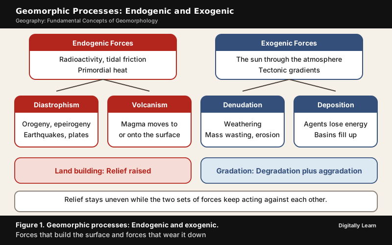
The surface of the earth is uneven because two sets of forces act on it at once. Endogenic forces come from within the earth. Their energy is mostly generated by radioactivity, rotational and tidal friction and primordial heat from the origin of the earth, and they are mainly land building. Exogenic forces derive their energy from the atmosphere, ultimately from the sun, and from gradients created by tectonic factors. They are mainly land wearing.
Because endogenic forces continuously raise or build up parts of the surface, exogenic processes fail to even out the relief. Differences in height therefore remain as long as the two opposing actions continue.
| Point | Endogenic forces | Exogenic forces |
|---|---|---|
| Source of energy | Radioactivity, rotational and tidal friction, primordial heat | The atmosphere and the sun, plus gradients created by tectonics |
| Main effect | Land building | Land wearing |
| Processes | Diastrophism and volcanism | Weathering, mass wasting, erosion, transportation and deposition |
| Result | A tectonically controlled, uneven crustal surface | Degradation of high relief and aggradation of basins |
Diastrophism and Volcanism: The Endogenic Processes
All processes that move, elevate or build up portions of the earth's crust come under diastrophism. They include four groups.
- Orogenic processes, which involve mountain building through severe folding and affect long and narrow belts of the crust.
- Epeirogenic processes, which involve the uplift or warping of large parts of the crust.
- Earthquakes, which involve local, relatively minor movements.
- Plate tectonics, which involves horizontal movement of crustal plates.
Orogeny is a mountain building process, whereas epeirogeny is a continent building process. Through all four there can be faulting and fracturing of the crust, and the resulting changes in pressure, volume and temperature induce metamorphism of rocks.
The movement of molten rock, or magma, onto or toward the earth's surface, together with the formation of many intrusive and extrusive volcanic forms, comes under volcanism. Because geothermal gradients, heat flow, crustal thickness and crustal strength all vary, endogenic forces do not act uniformly. This is why the original, tectonically controlled crustal surface is itself uneven before any exogenic process begins.
Gradation, Degradation and Aggradation
The levelling of the relief variations of the earth's surface by exogenic processes is called gradation. It has two halves. Degradation is the wearing down of relief and elevations. Aggradation is the filling up of basins and depressions. Weathering, mass wasting and erosion are degradational processes, and deposition is the process by which depressions are filled up.
All exogenic processes together are covered by the general term denudation. The word comes from "denude", to strip off or uncover, and denudation includes weathering, mass wasting or mass movement, erosion and transportation.
Geomorphic Processes, Agents and the Role of Gravity
The endogenic and exogenic forces that cause physical stresses and chemical actions on earth materials, and so change the shape of the surface, are called geomorphic processes. Any exogenic element of nature such as water, ice or wind that can acquire and transport earth materials is a geomorphic agent. A process is a force applied on earth materials, while an agent is the mobile medium, such as running water, groundwater, moving ice masses, wind, waves and currents, that removes, transports and deposits them.
Gravity is the force behind all of them. It is a directional force that activates all downslope movement of matter, and it also causes stresses in earth materials. Indirect gravitational stresses activate wave and tide induced currents and winds. Without gravity and gradients there would be no mobility, and so no erosion, transportation or deposition.
The basic reason for weathering, mass movement and erosion is the development of stresses in earth materials. Gravity produces shear stresses that break rocks and earth materials. Temperature changes, crystallisation and melting add molecular stresses, and chemical processes loosen the bonds between grains and dissolve soluble minerals or cementing material.
Rock Structure, Porosity and Permeability as Controls
Climatic factors being equal, the intensity of exogenic processes depends on the type and structure of rocks. Structure here includes folds, faults, the orientation and inclination of beds, joints, bedding planes, the hardness or softness of minerals, their chemical susceptibility and the permeability or impermeability of the rock. Different rocks offer different resistance to different processes, so they wear at different rates and give rise to differences in topography.
Permeability deserves care because it is easily confused with porosity. Porosity is the share of a rock that is open space. Permeability is the ability of a rock or soil to let fluids flow through it. It is related to porosity but also depends on the shape of the pores and on how well they are connected.
Chalk is a highly porous rock, with porosity of 35 to 47 per cent, so it can hold a great deal of water in its pores. Clay is also very porous, with a porosity above 50 per cent, but its pores are so fine that water passes through very slowly, so clay is relatively impermeable and forms the layers that hold water back. The Deccan Traps are a further example, since this basaltic formation has high porosity but low permeability and is a poor aquifer.
This matters in geomorphology because water enters, dissolves or lubricates a rock only if it can move through it. Permeable and soluble rocks such as limestone let groundwater do its work, which is why karst topography develops only in such rocks.
Climate as a Control: Climatic Geomorphology
Temperature and precipitation are the two important climatic elements that control the exogenic processes, so these processes vary from one climatic region to another. The density, type and distribution of vegetation, which depend largely on precipitation and temperature, also affect them. Within a single climatic region the processes vary again with altitude, with the aspect of the slope, with the insolation received by north and south facing slopes compared with east and west facing slopes, with wind speed and direction, with the kind and intensity of precipitation, and with the daily range of temperature and the frequency of freezing and thawing.
The branch of the subject that studies the role of climate in shaping landforms is climatic geomorphology. It can use relict landforms, those left from an older climate, to infer ancient climates. Its schemes of morphoclimatic zones mark regions where landforms are linked to present or past climates. Only some processes and landforms are zonal, meaning tied to a climate, and the rest are azonal. Zone boundaries are not sharp, and only the desert, glacial, periglacial and a few coastal zones are clearly justified.
Davis himself recognised climate by adding arid and glacial cycles to his "normal" cycle for temperate climates. The landforms of a region may also have formed under a climate different from today's, so a present climate alone cannot explain every feature.
Time, Stage and Equifinality: Reading a Landform's History
Every landform has a beginning. Once formed, it may change in shape, size and nature slowly or fast as the processes and agents continue to act. If the climate changes, or landmasses move vertically or horizontally, the intensity of the processes or the processes themselves may change, and this modifies the landform again. Evolution here means stages of transformation, either of a part of the earth's surface from one landform into another or of an individual landform after it has formed. Each landform therefore has a history of development.
The effects of most exogenic processes are small and slow, and they may be imperceptible in a short span of time. In the long run, because of continued fatigue, they affect rocks severely.
Reading that history is not always simple, because of equifinality. In geomorphology it means that similar landforms might arise from quite different sets of processes. A near-level plain, for example, may be a peneplain formed by stream erosion or a pediplain formed by the joining of pediments, and the two differ more in their history than in their final shape. A landform alone therefore does not always reveal how it was made, and the structure, process and stage of the region must be checked as well.
Weathering: Breaking Down Rock in Place
What Weathering Is and Why It Is an In-Situ Process
The action of the elements of weather and climate on earth materials is called weathering. It is defined as the mechanical disintegration and chemical decomposition of rocks through the actions of weather and climate. Very little or no motion of material takes place, so weathering is an in-situ, or on-site, process. This is what separates it from erosion, which involves the transport of rocks and minerals by agents such as water, ice, snow, wind, waves and gravity.
Weathering is conditioned by many complex geological, climatic, topographic and vegetative factors, and climate is of particular importance. Not only do the weathering processes differ from climate to climate, but so does the depth of the weathering mantle, the layer of weathered material above fresh rock.
There are three major groups of weathering processes, namely chemical, physical (also called mechanical) and biological weathering. Very rarely does any one of them operate completely by itself, but quite often one of them dominates. Chemical and physical weathering often go hand in hand, because cracks opened by physical weathering expose more surface to chemical attack.
Chemical Weathering: Solution, Carbonation, Hydration and Oxidation
A group of processes, namely solution, carbonation, hydration, oxidation and reduction, act on rocks to decompose, dissolve or reduce them to a fine clastic state through chemical reactions with oxygen, surface and soil water and other acids. Water and air, meaning oxygen and carbon dioxide, along with heat must be present to speed up the reactions. The decomposition of plants and animals adds to the carbon dioxide underground.
| Process | What happens | Example |
|---|---|---|
| Solution | A mineral dissolves completely in water | Halite and gypsum dissolve in rainwater |
| Carbonation | Carbon dioxide dissolved in water forms carbonic acid, which attacks minerals | Limestone dissolves, forming caves and karst |
| Hydration | Water molecules attach to a mineral | Anhydrite becomes gypsum |
| Oxidation | Minerals combine with oxygen | Iron in a rock turns reddish-brown |
Rainwater therefore weathers rock in two ways at once. The carbon dioxide dissolved in it makes carbonic acid, and the oxygen dissolved in it oxidises minerals such as iron compounds. Limestone and dolomite are rich in calcium carbonate, which dissolves easily in carbonated water, that is, rainwater that has absorbed carbon dioxide. This is why limestone regions develop sinkholes and caves, while the same rainwater only reddens and crumbles an iron-bearing rock.
Physical Weathering: Temperature, Pressure Release, Frost and Salt
Physical or mechanical weathering depends on applied forces. They may be gravitational forces such as overburden pressure, load and shearing stress, expansion forces due to temperature changes, crystal growth or animal activity, or water pressures controlled by wetting and drying cycles. Many of these forces act both at the surface and within the rock, and they lead to rock fracture. Most physical weathering is caused by thermal expansion and pressure release. Each step is small and slow, but repeated contraction and expansion fatigue the rock and do great damage in the end.
- Thermal stress: Rock expands and contracts with temperature. The effect is greatest in deserts, where the daily range of temperature is large, and repeated cycles gradually weaken the rock until it splits into blocks.
- Pressure release: When erosion removes the load above deeply buried granite, the outer parts expand and fractures form parallel to the surface, so that sheets of rock break away.
- Frost wedging: Water in cracks expands by about 9.2 per cent when it freezes and widens the crack, but it works only in small, tortuous fractures in rock that is almost saturated.
- Salt weathering: Salt solutions seep into cracks and evaporate, and the growing salt crystals press on the rock. It is most common in arid climates and along coasts.
Biological Weathering and Exfoliation
Biological weathering is the contribution to, or removal of, minerals and ions from the weathering environment, together with physical changes due to the growth or movement of organisms. Burrowing and wedging by organisms such as earthworms, termites and rodents expose new surfaces to chemical attack and help moisture and air to penetrate. Plant roots exert a great pressure on earth materials and break them apart mechanically. Decaying plant and animal matter produces humic, carbonic and other acids that increase decay and the solubility of some elements. Human beings also take part when they disturb vegetation, plough and cultivate soils, and mix air, water and minerals in new ways.
Exfoliation is a special effect of weathering. It is a result and not a process. Exfoliation is the flaking off of more or less curved sheets or shells from rock or bedrock, which leaves smooth, rounded surfaces. It can come from expansion and contraction induced by temperature changes. Exfoliation domes form through unloading, and tors form through thermal expansion.
| Type | Main processes | Typical result |
|---|---|---|
| Chemical | Solution, carbonation, hydration, oxidation and reduction | Rock decomposed or dissolved, caves in limestone |
| Physical | Unloading, thermal expansion and contraction, frost wedging, salt crystal growth | Cracked, flaked or blocky rock, exfoliation domes and tors |
| Biological | Burrowing, root pressure, acids from decaying matter | New surfaces opened to air, water and acids |
Significance of Weathering: Regolith, Ores and Biodiversity
Weathering breaks rock into smaller fragments and prepares the way for the formation of regolith and soils and for erosion and mass movements. Forests depend on the depth of the weathering mantle, and so in turn do the biomes and the biodiversity that forests support.
Weathering also concentrates valuable ores. When rocks weather, some materials are removed by physical or chemical leaching by groundwater, and the concentration of the remaining valuable material increases. This is called enrichment, and it is how some ores of iron, manganese, aluminium and copper become rich enough to be economic to mine and refine. Without weathering the concentration of the same material might not be sufficient to be worth exploiting.
Weathering aids mass wasting, erosion and the reduction of relief, and changes in landforms are a consequence of erosion. Even so, weathering is not a precondition for erosion, because glaciers can cause significant damage to rocks that are not weathered.
Soil Formation: Five Controlling Factors
Weathering is the first step in the formation of soil, or pedogenesis. The weathered mantle, or deposits brought from elsewhere, are colonised first by bacteria and by simple plants such as mosses and lichens. Dead remains build up humus, grasses, ferns and later bushes and trees take root, burrowing animals bring up particles, and the mass becomes porous and sponge-like. Finally a mature soil forms, a complex mixture of mineral and organic products.
Five basic factors control the process, namely parent material, topography, climate, biological activity and time. Parent material and topography are passive controls, while climate is an active factor. Soils are thin on steep slopes and thick over flat uplands. In wet equatorial climates, heavy rain removes calcium, sodium, magnesium and potassium and a major part of the silica, which is called desilication. In dry climates evaporation exceeds precipitation, and salts left behind form a crust called a hardpan. In tropical climates with intermediate rainfall, nodules of calcium carbonate, called kanker, form. Soils from recently deposited alluvium or glacial till are young and show no horizons or only poorly developed ones.
Mass Movement and Landslides
Mass Movement: Gravity Acting Without an Agent
The transfer of rock debris down slopes under the direct influence of gravity is called mass movement. No geomorphic agent such as running water, glaciers, wind, waves or currents takes part in the process. The air, water or ice does not carry the debris from place to place; if anything, the debris carries air, water or ice with it. This is why mass movement is not counted as erosion even though material shifts from one place to another. It differs from stream erosion in that the debris is not entrained in a moving medium, and the line between a mudflow and a very muddy stream is not sharp.
Gravity acts on all matter, both bedrock and the products of weathering, so weathering is not a prerequisite for mass movement, although it aids it. Mass movements are very active on weathered slopes. Materials on a slope resist the disturbing forces and yield only when the force exceeds their shearing resistance. Weak unconsolidated materials, thinly bedded rocks, faults, steeply dipping beds, vertical cliffs or steep slopes, abundant precipitation and torrential rain, and scarcity of vegetation all favour mass movement.
Several activating causes come before a movement begins.
- Removal of support from below, naturally or by human action.
- An increase in the gradient and height of slopes.
- Overloading by natural deposits or artificial filling.
- Overloading by heavy rainfall, which saturates and lubricates slope materials.
- Removal of material or load from the original slope surface.
- Earthquakes, explosions or machinery.
- Excessive natural seepage.
- Heavy drawdown of water from lakes, reservoirs and rivers.
- Indiscriminate removal of natural vegetation.
Types of Mass Movement: Creep, Flows, Slides and Falls
Mass movements range from slow to rapid and affect shallow to deep columns of material. They include creep, flow, slide and fall. Landslides are the relatively rapid and perceptible movements, and the material involved is relatively dry.
| Class | Type | How it moves |
|---|---|---|
| Slow movement | Soil creep | Imperceptibly slow, steady downslope movement, shown by curved tree trunks, bent fences and tilted poles |
| Solifluction | Gradual downslope movement linked to freeze and thaw | |
| Rapid flow | Earthflow and mudflow | Slope material liquefies and runs out. A mudflow is wet enough to flow rapidly and has at least 50 per cent sand, silt and clay sized particles |
| Debris flow and debris avalanche | Loose soil, rock, water and air flow as a slurry. A debris avalanche is a very rapid to extremely rapid debris flow | |
| Landslide | Slump | One or several units of rock debris slip with a backward rotation |
| Debris slide | Rapid rolling or sliding of debris without backward rotation | |
| Debris fall | Nearly free fall of debris from a vertical or overhanging face | |
| Rockslide | Individual rock masses slide down bedding, joint or fault surfaces | |
| Rock fall | Free fall of rock blocks from the superficial layers of a steep slope |
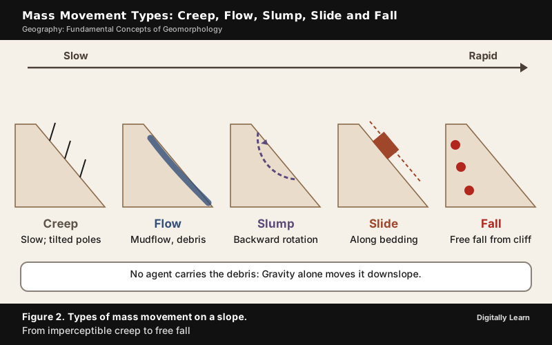
Rock fall differs from rockslide because it affects only the superficial layers of the rock face, while a rockslide affects material to a substantial depth. Slides occur as planar failures along discontinuities such as steeply dipping bedding planes. Falls separate along fractures, joints and bedding planes.
Why Landslides Differ in the Himalayas and the Western Ghats
Debris avalanches and landslides occur very frequently in the Himalayas. The range is tectonically active, it is made mostly of sedimentary rocks and of unconsolidated and semi-consolidated deposits, and its slopes are very steep. The Nilgiris and the Western Ghats along the west coast are relatively stable tectonically and are mostly made of very hard rocks, yet landslides and debris avalanches occur there too, though less often.
The Ghats have their own causes. Many slopes are steep, with almost vertical cliffs and escarpments. Mechanical weathering from temperature changes and large daily ranges is pronounced. Heavy rain falls over short periods, so rock falls occur quite frequently along with landslides and debris avalanches. Rainfall is the main natural trigger in both ranges, and landslides in India mostly occur in the monsoon season, although heavy rain outside the monsoon, as in the Kedarnath event of 2013, and earthquakes, as in the Sikkim earthquake of 2011, also set slopes moving.
| Point | Himalayas | Western Ghats and Nilgiris |
|---|---|---|
| Tectonics | Active | Relatively stable |
| Rocks | Mostly sedimentary rocks and unconsolidated and semi-consolidated deposits | Mostly very hard rocks |
| Slopes | Very steep | Many steep slopes with almost vertical cliffs and escarpments |
| Main triggers | Steepness on weak material, earthquakes, heavy rain | Temperature-driven weathering and heavy rain over short periods |
| Typical movement | Debris avalanches and landslides, very frequent | Rock falls with landslides and debris avalanches, less frequent |
About 0.42 million sq km, or 12.6 per cent of India's land area excluding snow-covered area, is prone to landslides. Of this, 0.18 million sq km lies in the North East Himalaya, including Darjeeling and Sikkim, 0.14 million sq km in the North West Himalaya (Uttarakhand, Himachal Pradesh and Jammu and Kashmir), 0.09 million sq km in the Western Ghats and Konkan hills, and 0.01 million sq km in the Eastern Ghats of the Araku area in Andhra Pradesh. The two Himalayan regions together account for 0.32 million sq km.

Landslide Zones, Consequences and Mitigation in India
Landslides are controlled largely by highly localised factors, unlike earthquakes or cyclones, which are controlled by regional factors. Collecting information and monitoring the possibility of a landslide is therefore difficult and very costly. On the basis of geology, geomorphic agents, slope, land use, vegetation cover and human activity, India is divided into vulnerability zones.
- Very high vulnerability: Highly unstable, relatively young mountains of the Himalayas and the Andaman and Nicobar Islands, high-rainfall steep slopes of the Western Ghats and Nilgiris, the north-eastern region, areas with frequent earthquake shaking, and areas of intense human activity such as road and dam construction.
- High vulnerability: Similar conditions, differing only in the combination, intensity and frequency of the controlling factors. All the Himalayan states and the north-eastern states except the plains of Assam fall here.
- Moderate to low vulnerability: Low-rainfall areas such as Ladakh and Spiti, the Aravali, and rain shadow areas of the Western and Eastern Ghats and the Deccan plateau. Landslides due to mining and subsidence are common in states such as Jharkhand, Odisha and Chhattisgarh.
The direct area of a landslide is small, but road blocks, destroyed railway lines and channels blocked by rock falls have far-reaching effects. A river diverted by a landslide can cause floods and loss of life and property, and the difficulty of movement slows development in hill areas.
Mitigation has to be area-specific. It includes restricting road, dam and other construction in high vulnerability zones, limiting agriculture to valleys and moderate slopes, controlling the growth of large settlements, large-scale afforestation, bunds to reduce the flow of water, and terrace farming in the north-eastern hill states where jhumming is still practised.
Landslide Mapping and Hazard Zonation
Mapping turns these ideas into a working tool for planners. Under the National Landslide Susceptibility Mapping programme, launched in 2014‑15, the Geological Survey of India has completed susceptibility mapping of about 0.43 million sq km (4.3 lakh sq km) of landslide-prone areas, slightly more than the 0.42 million sq km counted as prone outside snow-covered land; about 42,093 sq km of it lies in Himachal Pradesh. The National Remote Sensing Centre of ISRO has published the Landslide Atlas of India (2023), which holds an inventory of about 80,000 landslides mapped between 1998 and 2022 in 17 states and 2 Union Territories in the Himalayas and Western Ghats.
The atlas has three kinds of inventory, seasonal, event-based and route-wise. The seasonal inventory covers the 2014 and 2017 rainy seasons for the whole country, the event-based inventory covers major triggering events such as Kedarnath, Kerala and the Sikkim earthquake of 2011, and the route-wise inventory covers selected tourist and pilgrimage routes. The atlas also ranks 147 districts in the 17 states and 2 Union Territories by their exposure to landslides in terms of key socio-economic parameters. Satellite data, including Cartosat, Resourcesat and Sentinel images, were used in the mapping.
Erosion, Transportation and Deposition
Erosion and the Energy of Its Agents
The acquisition and transportation of rock debris is called erosion. When massive rocks break into smaller fragments through weathering or any other process, erosional agents such as running water, groundwater, glaciers, wind and waves remove the fragments and transport them to other places, each in the manner its own dynamics allow. Abrasion by the rock debris that the agent carries also helps greatly. By erosion, relief degrades and the landscape is worn down. Erosion is largely responsible for the continuous change of the earth's surface.
Erosion and transportation are controlled by kinetic energy, the energy of motion. The movement of a glacier is slow, unlike water flow, yet erosion by glaciers is tremendous because of the friction caused by the sheer weight of the ice. Water is a much more powerful eroding force than wind, and wind is an effective agent in regions with sparse vegetation, little soil moisture and a large supply of unconsolidated sediment.
Agents Controlled by Climate and Agents That Are Not
Wind, running water and glaciers are controlled by climatic conditions. They represent the three states of matter, gaseous, liquid and solid. In humid regions with heavy rainfall, running water is the most important agent in degrading the land surface. In hot deserts wind is one of the two dominant agents, and sheet floods of running water also shape the land.
Two agents are not controlled by climate. The work of waves depends on location along the interface of the lithosphere and hydrosphere, which is the coastal region. The work of groundwater depends more on the lithological character of the region. Karst topography develops only if the rocks are permeable and soluble and water is available.
This split explains why a landscape cannot be read from climate alone. A coast anywhere in the world is shaped by waves, and a limestone block in any climate is worked by groundwater, while a glacier needs cold and a dune field needs dry, sandy ground.
Deposition, Sorting and Aggradation by Agents
Deposition is a consequence of erosion rather than a separate force. The erosional agents lose velocity, and so energy, on gentler slopes, and the materials they carry begin to settle. Coarser materials are deposited first and finer ones later, and depressions are filled up in this way. The same agents that erode (running water, glaciers, wind, waves and groundwater) therefore also act as aggradational or depositional agents.
Sorting shows how an agent worked. Delta deposits are well sorted with clear stratification, because the coarsest material settles first and silt and clay travel on into the sea. Glacial till is unassorted, with mostly angular to sub-angular fragments, whereas outwash laid down by meltwater streams is roughly stratified and assorted with somewhat rounded edges. Wind is a good sorting agent, because grains of different sizes settle at different wind speeds.
Landforms Made by Each Agent
Each agent produces its own set of landforms and leaves its imprint on them, so landforms are grouped as erosional or depositional.
| Agent | Erosional landforms | Depositional landforms |
|---|---|---|
| Running water | V‑shaped valleys, gorges, canyons, potholes, plunge pools, incised or entrenched meanders, river terraces | Alluvial fans, deltas, floodplains, natural levees, point bars, oxbow lakes |
| Groundwater (karst) | Swallow holes and sinkholes, uvalas, lapies, limestone pavements, caves | Stalactites, stalagmites, pillars |
| Glaciers | Cirques, horns, arêtes, U‑shaped valleys, hanging valleys, fjords | Till, moraines, eskers, outwash plains, drumlins |
| Waves and currents | Sea cliffs, wave-cut terraces, sea caves, sea stacks | Beaches, dunes, bars, barriers, spits, lagoons |
| Wind | Deflation hollows, blowouts, desert caves, mushroom, table and pedestal rocks, and with sheet floods, pediments and pediplains | Sand dunes such as barchans, parabolic, seif, longitudinal and transverse dunes |
A gorge is a deep valley with very steep to straight sides and is almost equal in width at top and bottom. A canyon has steep step-like side slopes and is wider at the top than at the bottom, so it is a variant of gorge. A meander is, strictly, a type of channel pattern rather than a landform; the landforms are what it leaves behind, such as incised meanders cut into rock and the oxbow lakes cut off from it.
Wind as an Agent: Deflation, Abrasion and Desertification
Wind erodes by deflation, abrasion and impact. Deflation is the lifting and removal of loose, fine particles from the surface by turbulent wind. Abrasion is the wearing of surfaces by wind-driven grains, and sand and silt act as effective tools while they are being carried. Impact is the sheer force of momentum when sand is blown against a rock surface, like sand-blasting. Wind carries particles by suspension, by saltation, which is skipping or bouncing, and by creeping along the ground, and saltation is most important for grains up to 2 mm in size.
Where winds slow down, the grains settle, sorted by size, and form dunes. Most dunes in deserts shift, and only a few become stabilised, especially near human habitations.
Wind is not the only desert agent. Rain is scarce in deserts but comes down torrentially in a short time, and bare rocks weather fast under the large daily range of temperature. The weathered debris is therefore moved by wind and by sheet wash, with wind moving the fine material and sheet floods doing the general mass erosion.
Desertification is the gradual degradation of fertile land into arid desert through natural processes and human activities. Its immediate cause is the loss of most vegetation, driven by drought, climatic shifts, tillage, overgrazing and deforestation. Unprotected, dry soil surfaces blow away with the wind or are washed away by flash floods, leaving infertile lower layers that bake in the sun and become an unproductive hardpan. Wind erosion therefore removes the fertile top layer from land whose cover has already been lost, which is how aeolian processes contribute to land degradation. Desertification also loosens more sand and dust for the wind to lift, so sand and dust storms follow, with food insecurity and poverty among the effects.
Landform Evolution: Davis, Penck, King and Equilibrium
From Overland Flow to Valley Networks: Running Water at Work
Landform evolution is easiest to follow for running water, which has two components, overland flow as a sheet over the general land surface and linear flow in streams and rivers in valleys. Overland flow causes sheet erosion. Where the land is irregular the flow concentrates into narrow to wide paths, and friction removes material in the direction of flow, so that small, narrow rills form. The rills develop into long, wide gullies. The gullies deepen, widen and lengthen and unite to give a network of valleys.
In the early stages down-cutting dominates, and irregularities such as waterfalls and cascades are removed. In the middle stages the streams cut their beds more slowly and lateral erosion of the valley sides becomes severe. The valley sides are reduced to lower and lower slopes, and the divides between drainage basins are lowered until they are almost flattened. What is left is a lowland of faint relief with a few low resistant remnants called monadnocks.
Most erosional landforms of running water are linked to vigorous, youthful rivers on steep gradients. As the channels turn gentler through continued erosion, the water loses velocity and deposition becomes active. The gentler the channel, the greater the deposition. Downward cutting becomes less dominant and lateral erosion of the banks increases. This sequence from steep, cutting streams to gentle, depositing ones is the story that Davis's cycle tells in three stages.
Base Level: The Floor of Erosion
The lower limit for the vertical position of an erosion process is the base level. The modern term was introduced by John Wesley Powell in 1875, and William Morris Davis later used it in his cycle of erosion. The ultimate base level is the surface that results from the horizontal projection of sea level under landmasses. Topography tends towards this level through erosion and eventually forms a peneplain close to the end of a cycle of erosion.
There are other base levels too. Local base levels occur where a large body of water lies far from the sea or is cut off from it, as in an endorheic basin. Structural base levels occur where erosion is delayed by resistant rocks, for example in karst regions underlain by insoluble rock.
Base level can change with sea level, with tectonic movement, with river capture and with extensive sedimentation. A relative fall in base level makes a river readjust its profile, with knickpoints migrating upstream and terraces left behind, while stable or rising base levels allow rivers to aggrade. A rising base level may drown the lower course of a river and create a ria. The height of the base level also affects the position of deltas and river terraces.
Davis's Cycle of Erosion: Youth, Maturity and Old Age
The cycle of erosion, or geographic cycle, is an idealised model that explains the development of relief in landscapes. It starts with erosion after land is uplifted above a base level and ends, if conditions allow, in a peneplain. Davis conceived it in the 1880s while studying the Appalachians, set it out in detail in 1889 in The Rivers and Valleys of Pennsylvania, and described it as the geographical cycle in 1899. He divided the cycle into stages whose transition is gradual, like the stages of human life.
- Youth: Few, poorly integrated streams flow over the original slopes in shallow V‑shaped valleys, with no floodplains or only very narrow ones. Stream divides are broad and flat, with marshes, swamps and lakes, and waterfalls and rapids occur where hard rock is exposed. River incision dominates, and the height difference between uplands and valley bottoms increases rapidly.
- Maturity: Streams are plentiful and well integrated. The valleys are still V‑shaped but deep, and the trunk streams have wider floodplains in which they meander within the valley. The flat divides, swamps and marshes of youth disappear, the divides turn sharp and waterfalls and rapids vanish. Height differences between valley bottoms and uplands are at their greatest; then lateral erosion lowers the uplands faster than the rivers cut down.
- Old age: Smaller tributaries are few and have gentle gradients. Streams meander freely over vast floodplains with natural levees and oxbow lakes. Divides are broad and flat with lakes, swamps and marshes, and most of the landscape is at or slightly above sea level.
Davis acknowledged that a full cycle was a special case. Even so, his followers usually explained landscapes by rapid uplift followed by a long quiet period, so the model as most people understand it assumes rapid and episodic uplift. Slopes in the model evolve by decline, which means that initially steep slopes wear into successively gentler ones.

Peneplain, Monadnock and the Case Against the Cycle
The end form of the cycle is a peneplain, a low-relief plain formed by protracted erosion, from the Latin paene, meaning "almost", so "almost a plain". It is not necessarily featureless, since some peneplains are hilly because they reflect irregular deep weathering. Resistant remnants that stand above the surface are monadnocks, named after a mountain of that name in New Hampshire.
The cycle was never universally accepted, and the criticism is part of the concept. The model is mostly theoretical and deductive, and it does not take into account the complexity of tectonic movements or climate change. In its original form it was meant to explain relief in temperate landscapes where erosion by running water is assumed to be of prime importance, although it has been extended with modifications to arid, glacial, coastal, karst and periglacial areas.
Many geomorphologists find unacceptable the idea that little erosion takes place while the land is being uplifted. Doubts have also been raised about the stages following one another in a regular order, and the biological analogy of youth and old age may mislead. In 1964 a team led by Luna Leopold concluded that no peneplains exist over large areas in modern times.
The model has stayed in use for a limited purpose. It remains a common way to establish denudation chronologies, and the terms youth, maturity and old age are better used as descriptive summaries of regional topography than as a necessary sequence.
Polycyclic Relief and Rejuvenation
Landscapes that show evidence of more than one cycle of erosion are called polycyclic. The peneplain can be uplifted, and this starts a second cycle. Davis wrote in 1885 that the worn surface "must wait either until extinguished by submergence below the sea, or regenerated by elevation into a new cycle of life".
The process behind this is rejuvenation. A river is rejuvenated when it erodes the landscape in response to a lowering of its base level, which can be a fall in sea level or the rise of land. In Davis's scheme, regional uplift could raise the land and interrupt the cycle at any stage, re-energise the system and start a new period of down-cutting.
Rejuvenation leaves clear signs.
- Waterfalls and rapids, and knickpoints where the river steepens.
- River terraces, the surfaces that mark old valley floors or floodplain levels, often at several heights, and in pairs when they lie at the same height on both sides.
- Incised or entrenched meanders, in which vertical erosion begins to dominate over the lateral erosion that would normally occur.
Rejuvenated terrains usually have complex landscapes because remnants of older landforms are preserved locally. Between 1900 and 1939 many studies of denudation chronology used the model, and they usually identified two to five erosion cycles in a region.
Penck's Model: Uplift and Denudation Together
Walther Penck argued in the 1920s that uplift and denudation take place at the same time, at gradual and continuous rates, and not as one uplift followed by decay. His book Morphological Analysis of Landforms was published after his death, in 1924, by his father. In his model the steepness of valley slopes depends on the rate of uplift and not on the stage reached. Peneplains develop where the rate of uplift is low, intermediate forms where it is moderate, and Alpine forms where it is rapid.
| Point | Davis | Penck |
|---|---|---|
| Uplift | Rapid, then a long quiet period | Uplift and erosion together, gradual and continuous |
| What sets slope steepness | The stage of development | The rate of uplift |
| Slope change | Slope decline, slopes flatten with time | Slope replacement, flattening from the bottom upward |
| End forms | Peneplain with monadnocks | Peneplains, intermediate forms or Alpine forms by uplift rate |
| Best fit | Active tectonic margins, in the view of some authors | Passive margins and continental platforms, in the view of some authors |
Many, but not all, of Penck's ideas have been confirmed by later workers. Some geomorphologists now see the two models as compatible and even complementary since the advent of modern tectonic theory.
Slope Evolution: Decline, Replacement and Parallel Retreat
Three models of hillslope evolution dominated the twentieth century.
- Slope decline (Davis): The slope angle falls gradually as stream incision slows, and the slopes become gentler as they gather fine regolith.
- Slope replacement (Penck): It begins with a flattening of the lowermost slope that spreads upward and backward, so that the upper slope recedes and loses angle while staying steeper than the lower portions.
- Parallel slope retreat: It occurs when the rock strength of a slope stays constant and the debris at its base, such as talus, is continuously removed. The slope keeps its angle as it moves back. A durable cap rock over softer rock is a structural control that can keep this going.
Lester Charles King championed parallel retreat. He held that slope decline was a special case seen only in very weak rocks that could not maintain a scarp. The modern view is that slope evolution is more complex than any of the three classical models implies.
The idea of unequal activity adds that slopes in an area do not all develop at the same time. Stream erosion near the channels and an apparently unchanged upland can sit side by side.
King's Pediplain and Pediplanation in Arid Lands
Landscape evolution in deserts is mainly a matter of forming and extending pediments, the gently inclined rocky floors at the foot of mountains, with or without a thin debris cover. They form by erosion of the mountain front through lateral erosion by streams and sheet flooding. Once a pediment forms, the steep wash slope and the cliff or free face above it retreat backwards, a process called parallel retreat of slopes by backwasting. The pediments extend at the expense of the mountain front, and the mountain is reduced to a remnant called an inselberg. In this way the high relief of desert areas is reduced to low, featureless plains called pediplains.
The concepts of pediplain and pediplanation were first developed by Lester Charles King in his 1942 book South African Scenery. A pediplain is an extensive plain formed by the joining of pediments, and pediplains normally form in arid and semi-arid climates. Several pediplains may form at the same time at different heights, and they need not grade to a base level.
King set the pediplain against the peneplain. He held that a peneplain in the Davisian sense, resulting from slope reduction and down-wearing, does not exist in nature, and wrote that it should be redefined as an imaginary landform. The difference between the two lies mainly in the history and processes behind them and less in the final shape. In a pediplain the residual hills keep slopes as steep as those of the early stages, while Davis's peneplain was meant to have gentle residual slopes. Grove Karl Gilbert had earlier suggested that backwearing of slopes could shape landscapes into pediplains.
Equilibrium and Dynamic Equilibrium in Landforms
Equilibrium theory is a further model of landform development. Its starting point is that slopes are adjusted to geomorphic processes so that there is a balance of energy, the energy provided being just adequate for the work to be done. Harder rock develops steeper slopes and higher relief, and softer rock has gentler slopes and lower relief. The uniformity built into both the Davis and Penck models is thus called into question.
The clearest case is dynamic equilibrium. In mountains that are being uplifted and eroded at the same time, as in the Alps and the Himalayas, erosion reduces relief about as fast as uplift raises the land. The elevation and shape of the mountains then stay approximately the same, because removal and replacement are in balance. If the rate of erosion or the rate of uplift changes, the landscape passes through a period of adjustment until the slopes again reach a gradient at which erosion equals uplift. This echoes the basic point that relief survives as long as the opposing endogenic and exogenic actions continue.
Gilbert was an early contributor to this approach. His monograph The Geology of the Henry Mountains (1877) was an important early study, and on the basis of measurements over time he realised that denudation is not linear and began to develop theories from fluid dynamics and equilibrium concepts. Equilibrium theory has dominated fluvial geomorphology since the 1960s. It has serious shortcomings in tectonically stable areas and in places with little streamflow, such as deserts.
Using the Concepts: Indian Examples and Common Mix-Ups
Indian Examples of Geomorphic Processes
The surface of the earth is sensitive, and humans depend on it for their sustenance. Most of it was shaped over very long periods and misuse diminishes its potential quickly, so understanding the processes that shaped it is the first step to using it without disturbing its balance. Indian landscapes show these processes at work.
- Gorge: The valley of the Kaveri river near Hogenekal in Dharmapuri district, Tamil Nadu.
- Alluvial fan: A fan deposited by a hill stream on the way to Amarnath in Jammu and Kashmir.
- Delta and spit: The Krishna delta in Andhra Pradesh, and a spit in the Godavari delta.
- Meandering channel and oxbow lakes: The Burhi Gandak river near Muzaffarpur in Bihar.
- Glacier-fed rivers: The Bhagirathi is fed by meltwater from the snout (Gaumukh) of the Gangotri glacier, and it joins the Alaknanda at Deoprayag to form the Ganga.
- Landslide scars: The Shiwalik ranges near the river Sarada on the India-Nepal border in Uttar Pradesh.
- Coasts: The west coast of India is a high rocky retreating coast on which erosional forms dominate, and the east coast is a low sedimentary coast on which depositional forms dominate.
Coastal landforms also protect people. Offshore bars give the first buffer against storm and tsunami waves, followed by barriers, beaches, dunes and mangroves. If the sediment budget or the mangroves are disturbed, these forms erode and habitations meet the first strike of the waves.
Common Mix-Ups in Geomorphology Answers
Several terms in geomorphology are easily confused.
- Weathering, mass movement and erosion: Weathering is in-situ breakdown with no transport, mass movement is gravity moving debris without an agent, and erosion needs an agent that acquires and carries debris.
- Exfoliation: It is a result of weathering, not a process.
- Meander: It is a channel pattern, not a landform.
- Gorge and canyon, till and outwash: A gorge keeps almost the same width from top to bottom, while a canyon is wider at the top with step-like sides. Till is unsorted and angular, while outwash is roughly stratified with rounded edges.
- Peneplain and pediplain: A peneplain is the end of Davis's stream-erosion cycle, and a pediplain is the arid-land plain formed by joined pediments in King's view.
- Davis and Penck: Davis has one rapid uplift followed by wearing down, while Penck has uplift and erosion acting together.
Previous Year UPSC‑CSE Questions
Each Prelims question is explained option by option, and each Mains question comes with an answer outline.
- UPSC Prelims 2025Consider the following statements:
- I. In the context of effect of water on rocks, chalk is known as a very permeable rock whereas clay is known as quite an impermeable or least permeable rock.
- II. Chalk is porous and hence can absorb water.
- III. Clay is not at all porous.
Which one of the following is correct in respect of the above statements?
How to approach this Prelims question
Approach: Separate porosity from permeability. Porosity is open space in the rock; permeability is the ability to let fluid flow through, which depends also on how the pores connect. Chalk is highly porous and takes in water, so Statement II is correct and explains Statement I. Clay is porous too, with a porosity above 50 per cent, but its fine pores pass water very slowly, so Statement III, that clay is not at all porous, is false.
Trap to watch: Clay's low permeability tempts the reader to call it non-porous, which is Statement III's error.
Why each option is right or wrong:
- (a) Both Statement II and Statement III are correct and both of them explain Statement I: Wrong. Statement III is false, because clay is porous, though its pores are too fine to pass water easily.
- (b) Both Statement II and Statement III are correct but only one of them explains Statement I: Wrong. Statement III is not correct.
- (c) Only one of the Statements II and III is correct and that explains Statement I: Correct. Chalk is porous and takes in water, which explains why it is permeable; Statement III is false.
- (d) Neither Statement II nor Statement III is correct: Wrong. Statement II is correct, since chalk is highly porous.
Answer: (c) Only one of the Statements II and III is correct and that explains Statement I. Chalk is porous and permeable; clay is porous but relatively impermeable, so only Statement II is correct.
- UPSC Prelims 2024Consider the following statements :
- Statement‑I : Rainfall is one of the reasons for weathering of rocks.
- Statement‑II : Rain water contains carbon dioxide in solution.
- Statement‑III : Rain water contains atmospheric oxygen.
Which one of the following is correct in respect of the above statements ?
How to approach this Prelims question
Approach: Check each statement, then ask whether it explains the weathering by rain. Rainwater picks up carbon dioxide, which forms carbonic acid and attacks minerals by carbonation; it also carries dissolved oxygen, which oxidises minerals such as iron. Both are chemical weathering, so both statements are correct and both explain Statement I.
Trap to watch: Option (b) tempts those who link weathering only to carbonic acid and forget oxidation.
Why each option is right or wrong:
- (a) Both Statement‑II and Statement‑III are correct and both of them explain Statement‑I: Correct. Dissolved carbon dioxide drives carbonation and dissolved oxygen drives oxidation, and both weather rock.
- (b) Both Statement‑II and Statement‑III are correct, but only one of them explains Statement‑I: Wrong. Both gases take part in chemical weathering, not just one.
- (c) Only one of the Statements II and III is correct and that explains Statement‑I: Wrong. Rainwater carries both carbon dioxide and oxygen, so neither statement is false.
- (d) Neither Statement‑II nor Statement‑III is correct: Wrong. Both statements are correct.
Answer: (a) Both Statement‑II and Statement‑III are correct and both of them explain Statement‑I. Carbon dioxide in rain drives carbonation and dissolved oxygen drives oxidation, so both explain weathering.
- UPSC Mains 2026 GS‑IDiscuss the role of aeolian processes in desertification and land degradation.
Answer outline
The outline sets out what the question asks, the main arguments, relevant examples and the direction of the conclusion; it is not a full model answer.
Introduction: Aeolian processes are the erosion, transport and deposition of material by wind, strongest where vegetation and soil moisture are scarce.
Body (sub-themes to develop):
- Erosion: Deflation lifts loose fine particles; abrasion and impact wear surfaces.
- Transport and deposition: Suspension, saltation and creep; shifting dunes where winds slow.
- Desertification: Drought, overgrazing, tillage and deforestation strip vegetation; dry soil blows away and leaves an infertile hardpan.
- Effects: Loss of fertile topsoil, sand and dust storms, food insecurity and poverty.
Conclusion: Wind removes what lost vegetation leaves unprotected, so land cover is the key to checking degradation.
- UPSC Mains 2021 GS‑IDifferentiate the causes of landslides in the Himalayan region and Western Ghats.
Answer outline
Introduction: About 12.6 per cent of India's land area outside snow cover is prone to landslides, mostly in the Himalayas and the Western Ghats.
Body (sub-themes to develop):
- Himalayas: Tectonically active, mostly sedimentary rocks and unconsolidated and semi-consolidated deposits, very steep slopes; earthquakes and rain trigger slides.
- Western Ghats and Nilgiris: Relatively stable and made of very hard rocks, but with steep cliffs and escarpments, strong mechanical weathering and heavy rain over short periods, so rock falls are frequent.
- Common triggers: Monsoon rain, removal of vegetation, and road and dam construction.
Conclusion: The Himalayas fail because of what they are made of and where they sit, the Ghats because of their cliffs and rain, so remedies differ too.
- UPSC Mains 2016 GS‑I"The Himalayas are highly prone to landslides." Discuss the causes and suggest suitable measures of mitigation.
Answer outline
Introduction: The Himalayas fall in the very high and high landslide vulnerability zones, with about 0.32 million sq km of landslide-prone land.
Body (sub-themes to develop):
- Natural causes: Active tectonics and earthquakes, weak rocks, very steep slopes and heavy rain.
- Human causes: Road and dam construction, removal of vegetation and overloading of slopes.
- Restriction: Limit construction in high vulnerability zones, keep farming to valleys and moderate slopes, control large settlements.
- Action: Afforestation, bunds to slow water, and terrace farming in place of jhumming.
- Mapping: The Geological Survey of India's susceptibility mapping and the Landslide Atlas of India support zoning.
Conclusion: Landslides depend on local factors, so measures must be area-specific.
- UPSC Mains 2013 GS‑IBring out the causes for more frequent landslides in the Himalayas than in the Western Ghats.
Answer outline
Introduction: Of about 0.42 million sq km of landslide-prone land in India, 0.32 million sq km lies in the Himalayas and 0.09 million sq km in the Western Ghats and Konkan hills.
Body (sub-themes to develop):
- Tectonics: The Himalayas are active, the Ghats relatively stable.
- Rocks: Weak sedimentary and unconsolidated deposits against very hard rocks.
- Slopes and rain: Very steep slopes and heavy monsoon rain in the Himalayas.
Conclusion: The harder, stable Ghats slide less often, though cliffs and heavy rain still bring rock falls.
Sources
- NCERT: Fundamentals of Physical Geography (Class XI), Chapter 5, Geomorphic Processes
- NCERT: Fundamentals of Physical Geography (Class XI), Chapter 6, Landforms and their Evolution
- NCERT: India, Physical Environment (Class XI), Chapter 6, Natural Hazards and Disasters
- ISRO and NRSC: Landslide Atlas of India, 2023
- PIB: Risk mapping of hilly areas under the National Landslide Susceptibility Mapping programme
- USGS: Landslide types and processes, Fact Sheet 2004‑3072
- Wikipedia: Geomorphology
- Wikipedia: Aeolian processes
- Wikipedia: Desertification
- Wikipedia: Uniformitarianism
- Wikipedia: Denudation
- Wikipedia: Grove Karl Gilbert
- Wikipedia: Equifinality
- Wikipedia: Climatic geomorphology
- Wikipedia: Weathering
- Wikipedia: Mass wasting
- Wikipedia: Solifluction
- Wikipedia: Porosity
- Wikipedia: Chalk
- Wikipedia: Permeability (Earth sciences)
- Wikipedia: Clay
- Wikipedia: Aquitard
- Wikipedia: Cycle of erosion
- Wikipedia: William Morris Davis
- Wikipedia: Base level
- Wikipedia: Peneplain
- Wikipedia: Rejuvenation (river)
- Wikipedia: Walther Penck
- Wikipedia: Hillslope evolution
- Wikipedia: Pediplain
- UPSC: Civil Services Examination question papers
Editorial Disclaimer
Facts are drawn from the current NCERT geography textbooks, the ISRO Landslide Atlas of India, the USGS and other official and reference sources. Models of landform evolution are interpretations, and some authors assign them differently.
See more of our UPSC articles in Google Search
Add to Preferred Sources

