Table of Contents
Temperate Cyclones or Frontal cyclones or Mid-latitude or Wave cyclones or Extratropical Cyclone
Temperate or Extratropical cyclones are capable of producing anything from:- Cloudiness and mild showers to heavy gales, thunderstorms, blizzards, and tornadoes. Probably most significant of all atmospheric disturbances are mid latitude or temperate cyclones. Throughout the mid-latitudes, they dominate weather maps, are basically responsible for most day-to-day weather changes, and bring precipitation to much of the populated portions of the planet.
Consisting of large, migratory low-pressure cells, they are usually called depressions in Europe and lows or low pressure systems, wave cyclones, extra-tropical cyclones, or even simply (although not very precisely) as “storms” in the United States.
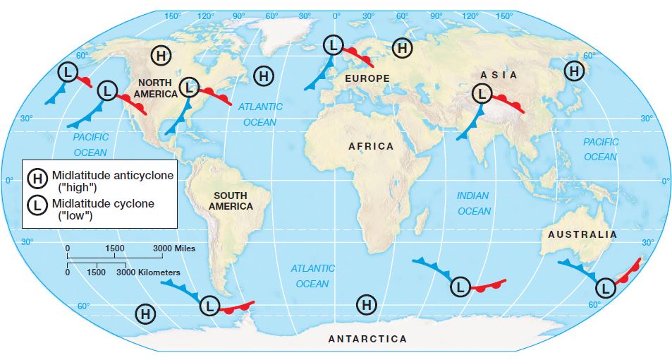
Mid-latitude or frontal cyclones are associated primarily with air mass convergence in regions between about 30° and 70° of latitude. Thus, they are found almost entirely within the band of westerly winds. Their general path of movement is toward the east, which explains why weather forecasting in the mid-latitudes is essentially a west-facing vocation.
- Because each mid-latitude cyclone or Temperate cyclones differs from all others in greater or lesser detail, any description must be a general one only. The discussions that follow, then, pertain to “typical” or idealized conditions.
- Moreover, these conditions are presented as Northern Hemisphere phenomena. For the Southern Hemisphere, the patterns of isobars, fronts, and wind flow should be visualized as mirror images of the Northern Hemisphere patterns.
Characteristics of Temperate Cyclones | UPSC IAS
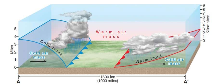
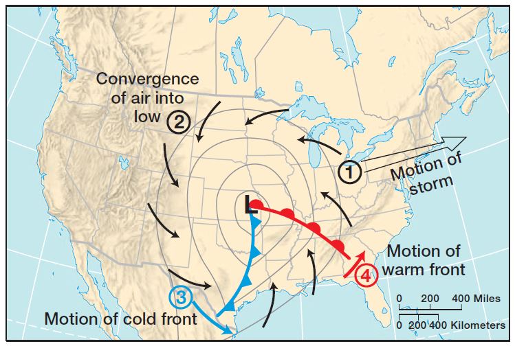
A typical mature mid-latitude cyclone or Temperate cyclones has a diameter of 1600 kilometers (1000 miles) or so. It is essentially a vast cell of low-pressure air, with ground-level pressure in the center typically between 990 and 1000 millibars. The system usually tends toward an oval shape, with the long axis trending northeast–southwest. Usually a clear-cut pressure trough extends southwesterly from the center.
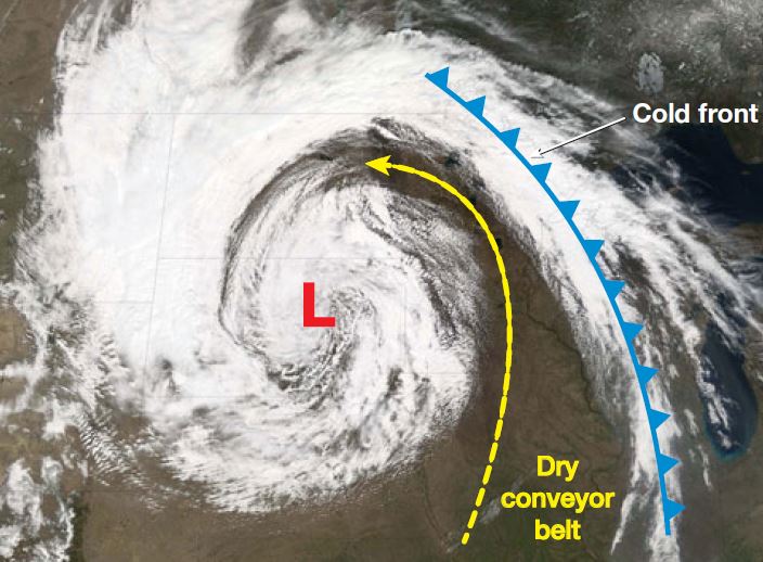
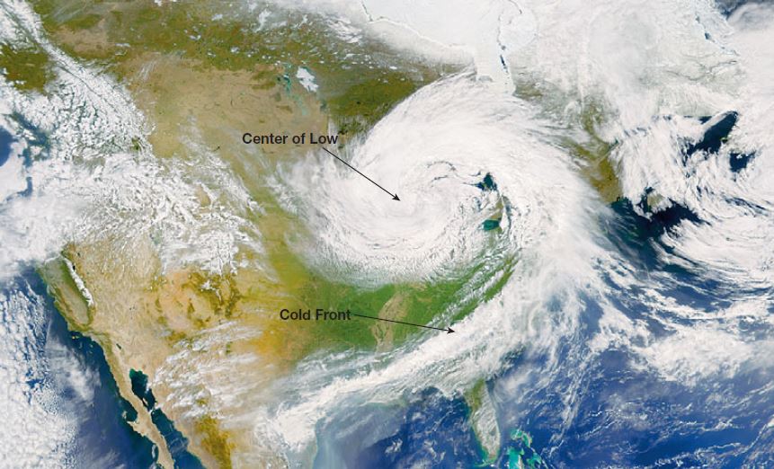
- Formation of Fronts: Mid-latitude cyclones or Temperate cyclones have a converging counterclockwise circulation pattern in the Northern Hemisphere. This wind flow pattern brings together cool air from the north and warm air from the south. The convergence of these unlike air masses characteristically creates two fronts: a cold front that extends to the southwest from the center of the cyclone and runs along the pressure trough extending from the center of the storm, and a warm front extending eastward from the center and running along another, usually weaker, pressure trough.
- Sectors: The two fronts divide the cyclone into a cool sector north and west of the center where the cold air mass is in contact with the ground, and a warm sector to the south and east where the warm air mass is in contact with the ground. At the surface, the cool sector is the larger of the two, but aloft the warm sector is more extensive. This size relationship exists because both fronts “lean” over the cool air. Thus, the cold front slopes upward toward the northwest and the warm front slopes upward toward the northeast.
- Clouds and Precipitation: Clouds and precipitation develop in the zones within a midlatitude cyclone or Temperate cyclones where air is rising and cooling adiabatically. Because warm air rises along both fronts, the typical result is two zones of cloudiness and precipitation that overlap around the center of the storm (where air is rising in the center of the low pressure cell) and extend outward in the general direction of the fronts.
Along and immediately behind the ground-level position of the cold front (the steeper of the two fronts), a band of cumuliform clouds usually yields showery precipitation. The air rising more gently along the more gradual slope of the warm front produces a more extensive expanse of horizontally developed clouds, perhaps with widespread, protracted, low-intensity precipitation. In both cases, most of the precipitation originates in the warm air rising above the fronts and falls down through the front to reach the ground in the cool sector.
This precipitation pattern does not mean that the entire cool sector has unsettled weather and that the warm sector experiences clear conditions throughout. Although most frontal precipitation falls within the cool sector, the general area to the north, northwest, and west of the center of the cyclone is frequently cloudless as soon as the cold front has moved on.
Thus, much of the cool sector is typified by clear, cold, stable air. In contrast, the air of the warm sector is often moist and tending toward instability, and so thermal convection and surface-wind convergence may produce sporadic thunderstorms. Also, sometimes one or more squall lines of intense thunderstorms develop in the warm sector in advance of the cold front.
Movements of Temperate Cyclones | UPSC IAS | Geography Optional
Midlatitude cyclones or Temperate cyclones are essentially transient features, on the move throughout their existence. Four kinds of movement are involved:
- The whole storm moves as a major disturbance in the westerlies, traversing the midlatitudes generally from west to east. The rate of movement averages 30 to 45 kilometers (about 20 to 30 miles) per hour, which means that the storm can cross North America in three to four days (often faster in winter than in summer).
- The route of a cyclone is likely to be undulating and erratic, although it moves generally from west to east, often in association with the path of the jet stream.
- The system has a cyclonic wind circulation, with wind generally converging counterclockwise (in the Northern Hemisphere) into the center of the storm from all sides.
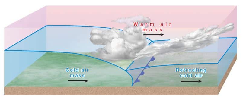
- The cold front usually advances faster than the center of the storm (the advancing dense, cold air easily displaces the lighter, warm air ahead of the front).
- The warm front usually advances more slowly than the center of the storm, causing it to appear to lag behind. (This is only an apparent motion, however. The warm front is actually moving west to east, just like every other part of the system.)
Life Cycle of Temperate Cyclones: Cyclogenesis | Geography Optional
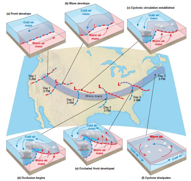
A typical midlatitude cyclone or Temperate cyclones progresses from origin to maturity, and then to dissipation, in about three to ten days. It is believed that the most common cause of cyclogenesis (the birth of cyclones) is upper troposphere conditions in the vicinity of the polar front jet stream. Most midlatitude cyclones begin as “waves” along the polar front.
- Waves are undulations or curves that develop in the paths taken by upper level winds such as a jet stream, and that the polar front is the contact zone between the relatively cold polar easterlies and the relatively warm westerlies.
- The opposing airflows normally have a relatively smooth linear motion on either side of the polar front. On occasion, however, the smooth frontal surface may be distorted into a wave shape.
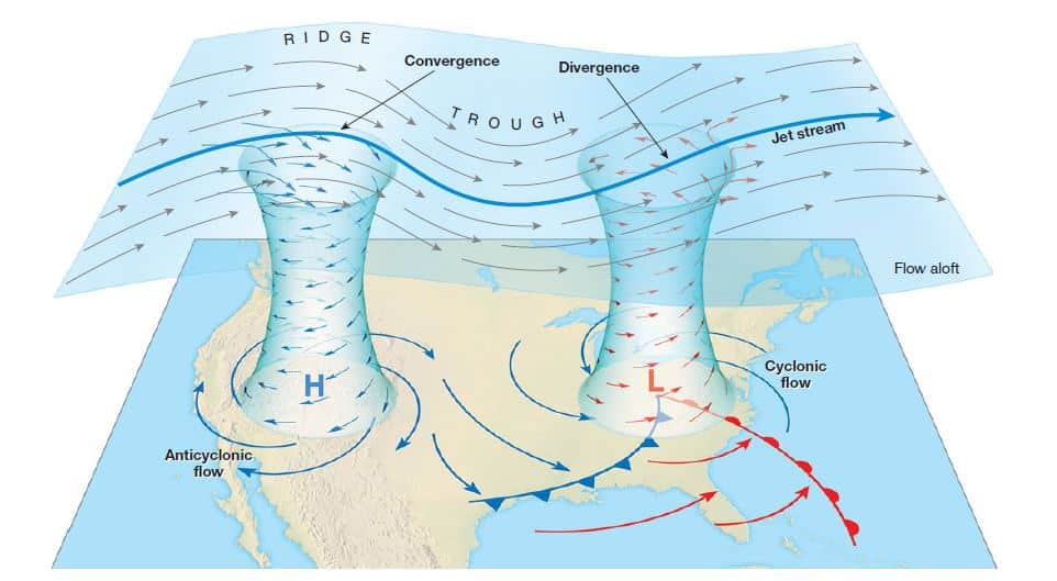
There appears to be a close relationship between upper level airflow and ground-level disturbances. When the upper airflow is zonal—by which we mean relatively straight from west to east – ground-level cyclonic activity is unlikely. When winds aloft begin to meander north to south in a meridional airflow, large waves of alternating pressure troughs and ridges are formed and cyclonic activity at ground level is intensified. Most mid-latitude cyclones or Temperate cyclones are centered below the polar front jet stream axis and downstream from an upper-level pressure trough.
A cyclone is unlikely to develop at ground level unless there is divergence above it. In other words, the convergence of air near the ground must be supported by divergence aloft. Such divergence can be related to changes in either speed or direction of the wind flow, but it nearly always involves broad north-to-south meanders in the Rossby waves and the jet stream.
- Various ground factors: such as topographic irregularities, temperature contrasts between sea and land, or the influence of ocean currents – can apparently initiate a wave along the front. For example, cyclogenesis also occurs on the leeward side of mountains. A low-pressure area drifting with the westerlies becomes weaker when it crosses a mountain range. As it ascends the range, the column of air compresses and spreads, slowing down its counterclockwise spin. When descending the leeward side, the air column stretches vertically and contracts horizontally. This change in shape causes it to spin faster and may initiate cyclonic development even if it were not a full-fledged cyclone before. This chain of events happens with some frequency in winter on the eastern flanks of the Rocky Mountains, particularly in Colorado, and with lesser frequency on the eastern side of the Appalachian Mountains, in North Carolina and Virginia. Cyclones formed in this way typically move toward the east and northeast and often bring heavy rain or snowstorms to the northeastern United States and southeastern Canada.
- Occlusion: Ultimately, the storm dissipates because the cold front overtakes the warm front. As the two fronts come closer and closer together, the warm sector at the ground is increasingly displaced, forcing more and more warm air aloft. When the cold front catches up with the warm front, warm air is no longer in contact with Earth’s surface and an occluded front is formed. This occlusion process usually results in a short period of intensified precipitation and wind until eventually all the warm sector is forced aloft and the ground-level low-pressure center is surrounded on all sides by cool air, a stable condition. This sequence of events weakens the pressure gradient and shuts off the storm’s energy and air lifting mechanism – and so its cloud-producing mechanism – and the storm dies out.
Conveyor Belt Model of Mid-latitude Cyclones | UPSC IAS
The description of mid-latitude cyclones we’ve just provided is sometimes called the “Norwegian” model because it was first presented by meteorologists in Norway in the 1920s. Although this explanation of midlatitude cyclones remains useful today, new data has provided a more complete explanation of these storms, especially air flow in the upper troposphere. A modern model, called the conveyor belt model, now offers a better explanation of the three dimensional aspects of these storms.
Weather Changes with the Passing of a Mid-latitude Cyclone | UPSC IAS
Although the exact details vary from storm to storm, basic structure and movements of a midlatitude cyclone or Temperate cyclones we just described can help us understand the often abrupt weather changes we experience on the ground with the passing of one of these storms. This is especially true when the cold front of a mid-latitude cyclone passes through in winter.
For example, imagine we’re in the warm sector of a mid-latitude cyclone or Temperate cyclones – the situation just before the cold front moves through. Remember, the whole storm is moving from west to east and so the cold front is moving closer to us hour by hour. When the cold front passes, all four elements of weather will likely change:
- Temperature: As the cold front passes, temperature drops abruptly because the cold front is the boundary between the cold air mass and the warm air mass of the storm. Pressure: Because the cold front is associated with a trough (a linear band of low pressure) extending south from the heart of the storm, as the front approaches, pressure will be falling, reaching its lowest point at the front. Then, as the cold front passes and the trough moves away, pressure will begin to rise steadily.
- Wind: Because of the overall converging counterclockwise wind pattern (in the Northern Hemisphere), winds in the warm sector come from the south (the situation before the cold front). Once the front passes, wind will tend to shift and come from the west or northwest.
- Clouds and Precipitation: The generally clear skies ahead of the cold front are replaced by cloudiness and precipitation at the front generated by the adiabatic cooling of the warm air as it is lifted along the front—to be replaced again some hours later by clear skies in the cold air mass behind the cold front. Similar changes, although of lesser magnitude, occur with the passage of a warm front.
Occurrence and Distribution of Temperate Cyclones | UPSC IAS
- At any given time, from 5 to 15 mid-latitude cyclones or Temperate cyclones exist in the Northern Hemisphere mid-latitudes, and an equal number in the Southern Hemisphere.
- They occur at scattered but irregular intervals throughout the zone of the westerlies. In part because temperature contrasts are greater during the winter, these migratory disturbances are more numerous, better developed, and faster moving in winter than in summer. They also follow much more equatorward tracks in winter.
- In the Southern Hemisphere, the Antarctic continent provides a prominent year-round source of cold air, and so vigorous cyclones are almost as numerous in summer as in winter. The summer storms are farther poleward than their winter cousins, however, and are mostly over the Southern Ocean. Thus, they have little effect on land areas.

