
Overview
Geography, ecology, and the endemic flora and fauna of the Sahyadri
A 1,600 km mountain spine across six states: orographic monsoon mechanism, the shola-grassland mosaic, flagship endemic species, and the UNESCO 2012 World Heritage network.
Previous Year UPSC-CSE Questions By the end you will be able to draft model answers for the following UPSC questions. Each question carries a collapsible framework showing how to approach it in the exam.
- UPSC Prelims 2013 General StudiesIn which of the following States is lion-tailed macaque found in its natural habitat?
- Tamil Nadu
- Kerala
- Karnataka
- Andhra Pradesh
Select the correct answer using the codes given below.
How to approach this Prelims question
Approach: Four-state evaluation testing knowledge of a Western Ghats endemic primate's distribution. The trap is including Andhra Pradesh.
Trap to watch: Aspirants may assume Andhra Pradesh's forested districts harbour the species because of geographic proximity. The trap is that the lion-tailed macaque is restricted to wet evergreen forest, which AP does not host.
Key facts to recall:
- Lion-tailed macaque: Macaca silenus; Endangered IUCN; Western Ghats endemic.
- Habitat: Tropical wet evergreen forest above 600 metres.
- Indian range: Tamil Nadu, Kerala, Karnataka only.
- Flagship reserve: Silent Valley National Park, Kerala.
Answer signal: 1, 2 and 3 only
- UPSC Prelims 2017 General StudiesFrom the ecological point of view, which one of the following assumes importance in being a good link between the Eastern Ghats and the Western Ghats?
How to approach this Prelims question
Approach: Four-option single-answer evaluation testing knowledge of inter-range ecological corridors.
Trap to watch: Aspirants may pick Nagarhole because of its Project Tiger fame. The trap is that the question asks about LINK between the two ghats, not WG-only fame.
Key facts to recall:
- Sathyamangalam Tiger Reserve: Tamil Nadu; declared tiger reserve 2013; ecological corridor between Eastern and Western Ghats.
- Nallamala Forest: Andhra Pradesh-Telangana; Eastern Ghats only.
- Nagarhole National Park: Karnataka; Western Ghats only.
- Seshachalam Biosphere Reserve: Andhra Pradesh; Eastern Ghats only.
Answer signal: Sathyamangalam Tiger Reserve
- UPSC Mains 2013 GS-IBring out the causes for more frequent landslides in the Himalayas than in the Western Ghats.
How to structure the answer in the exam
Introduction: Open with the structural difference: the Himalayas are a young fold mountain belt formed by the ongoing collision of the Indian and Eurasian plates; the Western Ghats are the much-older uplifted western escarpment of the Deccan plateau, dating from the basaltic flows approximately 65 million years ago. The age difference frames every subsequent contrast.
Body (sub-themes to develop):
- Tectonic activity: Himalayas show approximately 5 millimetres per year of active uplift plus high seismicity (zones IV and V); Western Ghats have negligible current uplift and lower seismicity.
- Slope geometry: Himalayan scarps are steeper and more vertical; Western Ghats are gentler peneplain remnants.
- Soil and bedrock: Himalayan slopes carry thinner, unconsolidated glacial-fluvial sediments; Western Ghats have deeper laterite-basaltic soil cover that buffers against shallow slips.
- Rainfall intensity: Himalayan cloudbursts deliver 50-100 millimetres per hour episodically; Western Ghats receive higher annual rainfall but over longer monsoon spells.
- Anthropogenic pressure: Massive Himalayan road and hydropower infrastructure (Char Dham, frontier highways) plus terrace agriculture destabilise slopes; Western Ghats land-use change is significant but lower in scale.
- Counterpoint: Western Ghats landslides DO occur, notably Kerala 2018 and Wayanad July 2024 (over 420 fatalities). Counterpoint reflects the increasing intensity of cloudbursts under climate change.
Conclusion: Conclude by noting that the Himalaya-Western Ghats contrast in landslide frequency reflects mountain age, tectonic activity, slope geometry, soil thickness, rainfall intensity profile, and human pressure. Yet the contrast is narrowing under climate change as Western Ghats cloudburst events intensify; the Wayanad 2024 disaster signals that the policy response on Eco-Sensitive Zone notifications (Gadgil and Kasturirangan recommendations) deserves renewed attention.
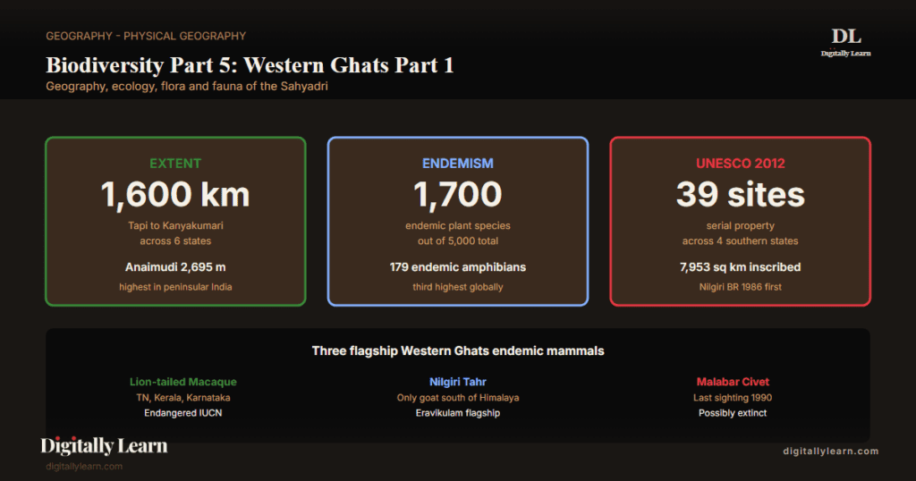
The Western Ghats, called the Sahyadri in Sanskrit and Marathi, form a continuous mountain chain running approximately 1,600 kilometres along the western edge of peninsular India from the Tapi river near Gujarat to Kanyakumari at the southern tip. The chain spans six states: Gujarat, Maharashtra, Goa, Karnataka, Kerala, and Tamil Nadu, covering an area of approximately 160,000 square kilometres at an average elevation of 1,200 metres. Conservation International recognises the Western Ghats together with Sri Lanka as one of 36 global biodiversity hotspots, characterised by exceptional endemism: approximately 7,400 flowering plant species with 1,273 exclusively endemic to the Western Ghats, 94 endemic amphibian species (out of 121, ~78% endemism) (the highest amphibian endemism of any Indian region), and over 200 freshwater fish species. The Western Ghats were inscribed as a UNESCO World Heritage Site in 2012, a serial property of 39 component sites across the four southern states.
Background and Historical Context
The Western Ghats regulate the south-west monsoon mechanics for the entire Indian subcontinent through their orographic effect. Moist Arabian Sea air ascending the western slopes deposits over 3,000 millimetres of rainfall annually in the windward zone, creating the wettest non-Himalayan landscape in India, while the leeward Deccan plateau receives less than 600 millimetres on the rain-shadow east. The Ghats are the source watershed for the Krishna, Godavari, and Cauvery river systems, the three peninsular rivers that sustain agriculture across Karnataka, Andhra Pradesh, Telangana, and Tamil Nadu. UPSC has examined Western Ghats topics in Prelims 2008, 2011, 2013, 2017, 2019, 2023; UPSC GS-I Mains covers WG geomorphology, monsoon mechanics, and biodiversity, while GS-III addresses conservation policy and the Gadgil-Kasturirangan reports.
What is the significance of the Western Ghats for India? The Ghats demonstrate three structurally distinct features. The chain's geological age traces to the Deccan Traps basaltic flows of roughly 65 million years before present, producing a mature peneplain landscape with steeply-rising scarp slopes facing west and gentle dip slopes facing east. The shola-grassland mosaic, a uniquely Western Ghats ecosystem found above 1,500 metres in the Nilgiris, Anaimalai, and Palni hills, combines patches of stunted evergreen forest in valley folds with open frost-resistant grassland on exposed slopes; the mosaic is the natural habitat of the endangered Nilgiri tahr. The Palghat Gap, a 32-kilometre lowland break at approximately 10.7 degrees north between the Nilgiris and the Anaimalai, separates the WG into a northern segment and a southern segment with distinct biogeographic communities and accounts for the higher endemism observed in the southern hills.
The Nilgiri Biosphere Reserve, India's first such reserve designated in 1986, supports a transboundary protected-area network spanning Tamil Nadu, Kerala, and Karnataka and inscribed as a UNESCO MAB biosphere reserve in September 1986. Project Tiger reserves in the Western Ghats include Periyar (Kerala), Anamalai (Tamil Nadu), Bandipur (Karnataka), Nagarhole (Karnataka), Mudumalai (Tamil Nadu), Sahyadri (Maharashtra), and Sathyamangalam (Tamil Nadu), the last of which serves as the critical ecological corridor between the Western and Eastern Ghats. The 2024 Wayanad landslide on 30 July, which killed over 420 people in Kerala, has reopened the policy debate over development controls in the Western Ghats and the implementation status of the Gadgil and Kasturirangan committee recommendations, examined in detail in the next article of this series.
Spatial Extent and Geological Setting
Sixteen hundred kilometres of mountain spine across six states
The Western Ghats extend for approximately 1,600 kilometres from the Tapi river valley near the Maharashtra-Gujarat border to Kanyakumari at peninsular India's southern tip. The chain runs broadly north to south, parallel to and approximately 30-50 kilometres inland from the Arabian Sea coast.
The Ghats traverse six Indian states in sequence: Gujarat (small northernmost segment), Maharashtra (Sahyadri proper), Goa, Karnataka (Malenadu region), Kerala (entire eastern boundary), and Tamil Nadu (Nilgiris, Anaimalai, Cardamom hills). Total area is approximately 160,000 square kilometres with average elevation 1,200 metres and the highest peak Anaimudi at 2,695 metres, in the Anaimalai hills of Kerala.
The Western Ghats are NOT a folded mountain chain like the Himalayas. They are the uplifted western escarpment of the Deccan plateau, originating in the geological events of approximately 65 million years ago when the Indian plate split from Madagascar during the Cretaceous-Tertiary transition.
The west-facing scarp rises sharply over 1,000-2,000 metres within a horizontal distance of 30-40 kilometres, generating the rain-bearing orographic effect on south-west monsoon winds. The eastern dip slopes descend gradually over 100-200 kilometres into the Deccan plateau, accounting for the gentle east-flowing drainage of the Krishna, Godavari, and Cauvery.
Orographic Mechanism: How the Western Ghats Make the Monsoon
Windward rainfall and Deccan rain-shadow
The Western Ghats are the single largest orographic barrier in peninsular India for the south-west monsoon. Moist Arabian Sea air, lifted by the western scarp, cools adiabatically, condenses, and deposits heavy rainfall on the windward slopes. Mahabaleshwar in Maharashtra receives approximately 6,000 millimetres annually, Agumbe in Karnataka exceeds 7,000 millimetres, and monsoon clouds drench Kerala's coastal stations through June to September.
Once the air crosses the crest, it descends, warms, and dries, creating the Deccan rain-shadow. Stations such as Pune receive only 700 millimetres and Bellary just 500 millimetres despite their proximity to the heavily-watered windward crest, producing the sharp east-west moisture divide of peninsular India.
- Windward rainfall: Above 3,000 millimetres annually across most windward stations; among the heaviest non-Himalayan rainfall in India.
- Leeward rain-shadow: Pune, Bellary, Solapur, Bijapur, and the broader Deccan plateau receive 500-800 millimetres; semi-arid agriculture dependent on irrigation.
- Mahabaleshwar Maharashtra: Approximately 6,000 millimetres annual rainfall; iconic windward hill station.
- Agumbe Karnataka: Over 7,000 millimetres; sometimes called the Cherrapunji of South India.
- Hydrological consequence: Krishna, Godavari, Cauvery, Periyar, Tungabhadra, Sharavati, Kali, Bhima, Netravati, Mhadei all rise on Ghats; the chain is the regional water tower.
| Station | Side of Ghats | Annual rainfall (mm) | Ecological character |
|---|---|---|---|
| Mahabaleshwar (MH) | Windward crest | ~6,000 | Tropical wet evergreen forest |
| Agumbe (KA) | Windward crest | >7,000 | Tropical wet evergreen rainforest |
| Munnar (KL) | Windward upper | ~2,500 | Shola-grassland mosaic |
| Kanyakumari (TN) | Southern tip | ~1,300 | Coastal tropical |
| Pune (MH) | Leeward foothill | ~700 | Semi-arid deciduous |
| Bellary (KA) | Deep leeward Deccan | ~500 | Semi-arid scrub |
| Bijapur (KA) | Deep leeward Deccan | ~600 | Semi-arid scrub |
Forest Types and the Shola-Grassland Mosaic
Four forest belts from coast to crest
Western Ghats forests vary with altitude and rainfall, generating four major forest types within the Indian portion of the hotspot. The Champion-Seth (1968) classification system frames the standard biogeographic vocabulary.
- Tropical wet evergreen forest: Below 800 metres on windward slopes; canopy 30-45 metres; Dipterocarpus, Mesua, Palaquium dominant; lion-tailed macaque habitat.
- Tropical semi-evergreen forest: Transitional belt 800-1,200 metres; mixed evergreen and deciduous canopy; declining in extent.
- Tropical moist deciduous forest: Leeward 600-1,200 metres; teak (Tectona grandis), terminalia, lagerstroemia dominant; tiger and elephant habitat.
- Montane wet temperate (shola-grassland): Above 1,500 metres in Nilgiris, Anaimalai, Palni hills; stunted evergreen in folds, grassland on exposed slopes; Nilgiri tahr habitat.
- Myristica swamp forest: Rare specialised wet evergreen variant in valley bottoms with permanent water-logged soils; few hundred hectares survive in coastal Karnataka and Kerala.
Endemic Flora: Why the Western Ghats Are India's Plant Endemism Centre
Roughly 1,273 endemic plant species concentrated below the Palghat Gap
Western Ghats endemic flora comprises approximately 1,273 flowering plant species exclusively endemic to the Ghats, drawn from a regional flora of approximately 7,400 flowering species per the latest taxonomic assessments. Endemism is heavily concentrated in the southern Ghats below the Palghat Gap, where the Anaimalai, Cardamom, and Agasthyamalai ranges host significantly higher plant endemism than the northern Sahyadri.
The hotspot is a Vavilov centre for cultivated black pepper, cardamom, ginger, and turmeric, all of which have wild ancestors in the Ghats. The Strobilanthes kunthiana (Neelakurinji), which flowers only once every twelve years, paints the Nilgiri shola-grasslands blue and was last in mass-bloom in 2018.
- Strobilanthes kunthiana (Neelakurinji): Twelve-year mass-flowering cycle; Nilgiri shola-grassland flagship; last major bloom 2018.
- Wild black pepper (Piper nigrum): Endemic to Kerala-Karnataka Ghats; Vavilov centre stock for global pepper cultivation.
- Cardamom (Elettaria cardamomum): Wild ancestor endemic to Cardamom Hills, Kerala; the hills are named after the spice.
- Myristica fragrans relatives: Endemic Myristica swamp forest holds rare nutmeg-family taxa restricted to a few hundred hectares.
- Garcinia indica (kokum): Endemic to coastal Karnataka and Goa Ghats; supports a regional culinary and pharmaceutical economy.
- Endemic ferns and orchids: Approximately 500 endemic taxa across the Anaimalai-Agasthyamalai belt.
Endemic Fauna: Lion-tailed Macaque, Nilgiri Tahr, Purple Frog
Three flagship endemic mammals and the amphibian endemism story
The Western Ghats sustain several of India's most iconic endemic vertebrates. The lion-tailed macaque (Macaca silenus) is restricted to evergreen forest canopies of Tamil Nadu, Kerala, and Karnataka, a distribution that UPSC Prelims 2013 tested. The Nilgiri tahr (Nilgiritragus hylocrius), formerly Hemitragus hylocrius, is the only mountain goat south of the Himalaya and a flagship of the shola-grassland mosaic.
The Malabar civet (Viverra civettina), last sighted in the wild in 1990, is critically endangered and possibly extinct. The Western Ghats also host the world's third-highest amphibian endemism after Madagascar and the New Guinea highlands, with the purple frog (Nasikabatrachus sahyadrensis), described only in 2003, being the most striking discovery.
- Lion-tailed macaque: Macaca silenus; Endangered IUCN; restricted to tropical wet evergreen canopy of Tamil Nadu, Kerala, Karnataka.
- Nilgiri tahr: Nilgiritragus hylocrius; Endangered; only mountain goat south of the Himalaya; Eravikulam National Park is the flagship reserve.
- Malabar civet: Viverra civettina; Critically Endangered; last confirmed sighting in 1990 near Calicut, Kerala; possibly extinct.
- Purple frog: Nasikabatrachus sahyadrensis; described 2003; spends most of life underground, emerges briefly for monsoon breeding.
- Nilgiri marten: Martes gwatkinsii; only marten of southern India; restricted to montane shola-grassland.
- Nilgiri langur: Trachypithecus johnii; Vulnerable; endemic to Western Ghats wet evergreen forest above 700 metres.
Protected Areas: Nilgiri Biosphere and the UNESCO 2012 Serial Property
Tiger reserves, biosphere reserves, and the WG to Eastern Ghats corridor
The Western Ghats host the densest network of protected areas of any Indian biogeographic region. The Nilgiri Biosphere Reserve, India's first such reserve declared in 1986 and granted UNESCO biosphere status in September 1986, spans approximately 5,520 square kilometres across Tamil Nadu, Kerala, and Karnataka. The UNESCO World Heritage inscription of 2012 covers 39 component sites totalling approximately 7,953 square kilometres across the four southern Ghats states.
Project Tiger reserves on the Ghats include Periyar, Anamalai, Bandipur, Nagarhole, Mudumalai, Sahyadri, and Sathyamangalam. Sathyamangalam, declared a tiger reserve in 2013, serves as the critical ecological corridor between the Western Ghats and the Eastern Ghats, the role tested by UPSC Prelims 2017.
- Nilgiri Biosphere Reserve: India’s first biosphere reserve 1986; UNESCO 1986; 5,520 sq km across TN/Kerala/Karnataka.
- Periyar Tiger Reserve: Kerala; one of India’s earliest tiger reserves; periyar river origin; Project Tiger flagship.
- Silent Valley National Park: Kerala; saved from a 1970s hydropower project after a landmark conservation campaign; tropical wet evergreen flagship.
- Eravikulam National Park: Kerala; Nilgiri tahr flagship reserve; shola-grassland; Kurinji bloom site.
- Sathyamangalam Tiger Reserve: Tamil Nadu; declared 2013; the WG-Eastern Ghats ecological corridor; tested Prelims 2017.
- Anamudi Shola National Park: Kerala; protects the shola-grassland around Anaimudi peak.
Prelims MCQ practice
Each question below tests one specific concept on the topic. Click to reveal the answer and a full option-wise explanation.
Q1. Consider the following statements about the Western Ghats:
- The Western Ghats run roughly 1,600 km along the western coast of India, from Gujarat in the north to Tamil Nadu in the south.
- The Western Ghats and Sri Lanka are jointly recognised as a single biodiversity hotspot.
- The Western Ghats are a UNESCO World Heritage site.
Which of the statements given above are correct?
- 1 and 2 only
- 2 and 3 only
- 1 and 3 only
- 1, 2 and 3
Show answer and explanation
Answer: 1, 2 and 3
Explanation.
Correct: d (1, 2 and 3). All three are correct. Western Ghats run around 1,600 km from Gujarat (Tapti valley) south through Maharashtra, Goa, Karnataka, Kerala, Tamil Nadu (terminating at Kanyakumari). Western Ghats and Sri Lanka are jointly recognised as a single Conservation International hotspot. The Western Ghats are inscribed as a UNESCO World Heritage site (2012, serial nomination of 39 sub-sites).
Q2. Consider the following statements about flagship fauna of the Western Ghats:
- Lion-tailed macaque (Macaca silenus) and Nilgiri tahr (Nilgiritragus hylocrius) are endemic to the Western Ghats.
- Malabar civet (Viverra civettina) is Critically Endangered and endemic to the Western Ghats.
- Asiatic Cheetah is a Western Ghats endemic.
Which of the statements given above are correct?
- 1 and 2 only
- 2 and 3 only
- 1 and 3 only
- 1, 2 and 3
Show answer and explanation
Answer: 1 and 2 only
Explanation.
Correct: a (1 and 2 only). Statement 1 is correct: lion-tailed macaque and Nilgiri tahr are Western Ghats endemics. Statement 2 is correct: Malabar civet is CR and endemic. Statement 3 is wrong: Asiatic Cheetah was historically found across dry grasslands and was declared extinct in India in 1952; it has NEVER been a Western Ghats species (the WG is wet-evergreen forest habitat, not cheetah habitat).
Q3. Consider the following statements about the shola-grassland ecosystem of the Western Ghats:
- Sholas are stunted montane evergreen forest patches confined to the high-altitude valleys and folds.
- The shola-grassland mosaic is found at elevations typically above 1,500-1,800 m in the Nilgiris, Anaimalais, and Palanis.
Which of the statements given above is/are correct?
- 1 only
- 2 only
- Both 1 and 2
- Neither 1 nor 2
Show answer and explanation
Answer: Both 1 and 2
Explanation.
Correct: c (Both 1 and 2). Both statements are correct. Sholas are stunted montane evergreen forest patches in high-altitude valleys, juxtaposed with grasslands on ridges. The shola-grassland mosaic occurs above 1,500-1,800 m in the southern Western Ghats (Nilgiris, Anaimalais, Palanis, Eravikulam plateau).
Q4. Consider the following statements about Western Ghats amphibian endemism:
- The Western Ghats are recognised as a major global amphibian-diversity hotspot with very high endemism.
- The purple frog (Nasikabatrachus sahyadrensis) is a unique fossorial frog endemic to the Western Ghats.
Which of the statements given above is/are correct?
- 1 only
- 2 only
- Both 1 and 2
- Neither 1 nor 2
Show answer and explanation
Answer: Both 1 and 2
Explanation.
Correct: c (Both 1 and 2). Both statements are correct. Western Ghats are a major global amphibian-diversity hotspot with most discovered species being endemics (many described in the last two decades by Indian herpetologists). The purple frog is a remarkable fossorial (burrow-dwelling) amphibian endemic to the Western Ghats, related to a Seychelles family and a relic of the Gondwana lineage.
Q5. Consider the following statements about Tiger Reserves in the Western Ghats:
- The Western Ghats landscape includes Tiger Reserves such as Anamalai, Periyar, Parambikulam, Mudumalai, Bandipur, Nagarhole, and Sahyadri.
- The Nilgiri Biosphere Reserve is a key landscape covering parts of Tamil Nadu, Karnataka, and Kerala.
Which of the statements given above is/are correct?
- 1 only
- 2 only
- Both 1 and 2
- Neither 1 nor 2
Show answer and explanation
Answer: Both 1 and 2
Explanation.
Correct: c (Both 1 and 2). Both statements are correct. The Western Ghats include major Tiger Reserves including Anamalai (TN), Periyar (Kerala), Parambikulam (Kerala), Mudumalai (TN), Bandipur (Karnataka), Nagarhole (Karnataka), and Sahyadri (Maharashtra). The Nilgiri Biosphere Reserve (UNESCO MAB) covers parts of TN, Karnataka, and Kerala, a key landscape.
Q6. Consider the following statements about the Western Ghats UNESCO World Heritage inscription:
- The Western Ghats UNESCO World Heritage site is a serial nomination of 39 sub-sites across the four states of Karnataka, Kerala, Tamil Nadu, and Maharashtra.
- The Western Ghats were inscribed in 2012.
Which of the statements given above is/are correct?
- 1 only
- 2 only
- Both 1 and 2
- Neither 1 nor 2
Show answer and explanation
Answer: Both 1 and 2
Explanation.
Correct: c (Both 1 and 2). Both statements are correct. The Western Ghats UNESCO World Heritage site is a serial nomination of 39 sub-sites across the four states of Karnataka, Kerala, Tamil Nadu, and Maharashtra. The site was inscribed in 2012.
Sources and Further Reading
- NCERT Class 11 India: Physical Environment, Chapter 5 – Natural Vegetation
- Wikipedia – Western Ghats
- Wikipedia – Nilgiri Biosphere Reserve
- Wikipedia – Shola
- Wikipedia – Lion-tailed macaque
- Wikipedia – Nilgiri tahr
- Wikipedia – Palghat Gap
- Wikipedia – Periyar National Park
- Wikipedia – Silent Valley National Park
- Wikipedia – Sathyamangalam Tiger Reserve
- Wikipedia – Biodiversity hotspot
Disclaimer
This explainer covers the Western Ghats biodiversity hotspot for UPSC preparation: its geography, endemic flora and fauna, the UNESCO World Heritage inscription, and the protected-area network across six states. Figures and conservation statuses follow the authoritative and are not a substitute for primary documents.


