
Overview
India's north-eastern bridge to South-east Asia
Tropical wet evergreen forests, India's only ape, and the one-horned rhinoceros recovery across north-east India.
Previous Year UPSC-CSE Questions By the end you will be able to draft model answers for the following UPSC questions. Each question carries a collapsible framework showing how to approach it in the exam.
- UPSC Prelims 2015 General StudiesConsider the following States:
- Arunachal Pradesh
- Himachal Pradesh
- Mizoram
In which of the above States do 'Tropical Wet Evergreen Forests' occur?
How to approach this Prelims question
Approach: Three-state evaluation testing knowledge of Indian forest-type distribution. The trap is including any Himalayan state in the tropical wet evergreen category.
Trap to watch: Aspirants may include Himachal Pradesh on the assumption that hill states host evergreen forest. The Western Himalaya hosts temperate evergreen, not tropical wet evergreen; the two are biogeographically distinct.
Key facts to recall:
- Tropical wet evergreen forest: Requires above 2,500 millimetres annual rainfall, low altitude, and warm year-round temperature.
- Indo-Burma range: Arunachal Pradesh, Assam south of Brahmaputra, Mizoram, parts of Meghalaya.
- Himachal Pradesh ecology: Western Himalaya; deodar, blue pine, oak; NOT tropical wet evergreen.
- Champion-Seth (1968) classification: Standard Indian forest-type framework used by ICFRE.
Answer signal: 1 and 3 only
- UPSC Prelims 2014 General StudiesConsider the following pairs:
- Dampa Tiger Reserve: Mizoram
- Gumti Wildlife Sanctuary: Sikkim
- Saramati Peak: Nagaland
Which of the above pairs is/are correctly matched?
How to approach this Prelims question
Approach: Three-pair matching testing protected-area and peak knowledge for north-east states.
Trap to watch: Aspirants may assume Gumti Wildlife Sanctuary belongs to a more commonly tested state. The trap is that Gumti is in Tripura, which receives less Prelims attention than Sikkim or Assam.
Key facts to recall:
- Dampa Tiger Reserve: Mizoram; one of India's tiger reserves notified in 1994; tropical wet evergreen ecosystem.
- Gumti Wildlife Sanctuary: Tripura, NOT Sikkim; on the Gumti river.
- Saramati Peak: Nagaland; approximately 3,826 metres; highest peak in the Naga Hills.
- Common Sikkim peaks: Kangchenjunga, Kabru, Pauhunri (NOT Saramati).
Answer signal: 1 and 3 only
- UPSC Mains 2023 GS-IIdentify and discuss the factors responsible for diversity of natural vegetation in India. Assess the significance of wildlife sanctuaries in rainforest regions of India.
How to structure the answer in the exam
Introduction: Open by stating that India's natural vegetation diversity is among the highest in any country owing to its biogeographic position at the junction of four hotspots: Himalaya, Indo-Burma, Western Ghats and Sri Lanka, and Sundaland. Rainforest regions, in particular the Indo-Burma north-east and the Western Ghats, host the country's most threatened ecosystems and the densest network of wildlife sanctuaries.
Body (sub-themes to develop):
- Latitudinal range: India spans 8 degrees N to 37 degrees N, supporting tropical, sub-tropical, temperate, and alpine vegetation belts.
- Altitudinal compression: Himalaya and Western Ghats compress climatic zones vertically; five Indo-Burma forest types occur within 1,800 metres of altitude in Arunachal alone.
- Rainfall gradient: From below 100 millimetres in the Thar to above 11,000 millimetres at Mawsynram; produces forest types from thorn-scrub to tropical wet evergreen.
- Soil heterogeneity: Alluvial, black, red, laterite, mountain, and desert soils each support distinctive vegetation.
- Biogeographic legacy: Plate-tectonic position at the India-Eurasia collision drives the hotspot concentration at the eastern and western mountain barriers.
- Human modifications: Jhum, terrace agriculture, plantations, urbanisation reshape native vegetation; this is the primary contemporary driver.
- Rainforest wildlife sanctuaries: Namdapha, Dehing Patkai, Silent Valley, Periyar, Anshi-Dandeli are flagship rainforest protected areas; they secure tropical evergreen forest endemics including hoolock gibbon, clouded leopard, lion-tailed macaque, Nilgiri tahr, and the recovering Bengal tiger.
Conclusion: Conclude by noting that India's vegetation diversity is a national resource of exceptional global value, sustained by a network of protected areas that requires continued funding under Project Tiger, Project Elephant, the Critical Wildlife Habitat framework, and CAMPA. Wildlife sanctuaries in rainforest regions are particularly load-bearing because rainforest endemics cannot adapt elsewhere; their conservation is therefore not substitutable.
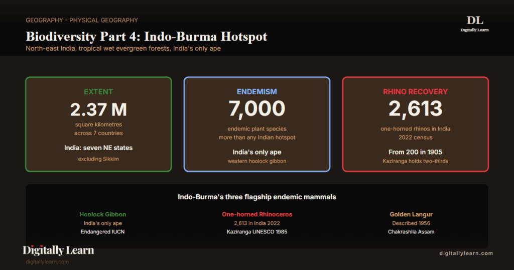
The Indo-Burma Biodiversity Hotspot is one of the most biologically threatened of the 36 global biodiversity hotspots designated by Conservation International. It covers approximately 2.37 million square kilometres spanning the eastern Himalayan foothills, the Brahmaputra and Irrawaddy lowlands, the Indochinese peninsula, and the southern Chinese province of Yunnan. The Indian portion includes the seven sister states of north-east India (excluding Sikkim, which lies in the Himalayan hotspot) and parts of West Bengal. Endemism is exceptional: approximately 7,000 endemic plant species, more than 1,300 bird species (the highest of any hotspot), the only ape in India (the western hoolock gibbon), and the recovering Indian one-horned rhinoceros at Kaziranga. Habitat loss has been severe; less than 5 per cent of original primary forest survives intact across the hotspot, placing Indo-Burma among the most-disturbed yet most-endemic hotspots on Earth.
Background and Historical Context
Indo-Burma sustains the cultural and economic lives of approximately 300 million people across India, Bangladesh, Myanmar, Thailand, Laos, Vietnam, Cambodia, and southern China, and supplies the headwaters of three major Asian rivers (the Brahmaputra, the Irrawaddy, and the Mekong). Within India, the hotspot covers all seven north-eastern states except Sikkim and parts of West Bengal, hosting the country's largest unbroken tropical evergreen forest landscape and the densest concentration of ethno-linguistic diversity. UPSC has examined Indo-Burma topics in Prelims 2011, 2014, 2015, 2019, 2022, and 2025; UPSC Mains GS-I covers natural vegetation diversity and wildlife sanctuaries while GS-III addresses cross-border biodiversity, jhum cultivation, and conservation infrastructure.
What is the significance of this hotspot for India? Indo-Burma demonstrates that high endemism can coexist with high anthropogenic pressure, a pattern that defines South-east Asian conservation. Three structural features distinguish it: first, the Brahmaputra-Ganga confluence creates the world's largest fluvial floodplain biodiversity zone with one-horned rhinoceros, swamp deer, and golden langur as flagship recoveries; second, the eastern Himalayan ranges descend to under 100 metres in Arunachal's Namdapha National Park within 50 horizontal kilometres of 4,500-metre peaks, packing tropical evergreen and alpine ecosystems into a single protected area; third, the indigenous shifting cultivation cycle known as jhum historically maintained landscape-level mosaic diversity but has been compressed from 15-20 year fallows to 3-5 year cycles under demographic pressure, eroding the secondary-forest regeneration that hotspot endemics depend on.
The North East Region Vision 2020 framework and the North-East Industrial Development Scheme 2024 create policy tension between connectivity expansion (Bharatmala, Trans-Arunachal Highway, frontier-area development) and hotspot integrity. The National Bamboo Mission, restructured in 2018-19 and extended through 2025-26, recognises bamboo as a critical resource for north-eastern livelihoods and forest regeneration following the 2017 Indian Forest Act amendment that removed bamboo grown on non-forest land from the timber definition. The Forest (Conservation) Amendment Act 2023 exempted strategic projects within 100 kilometres of international borders from forest-clearance norms, a provision that materially affects Arunachal Pradesh, Nagaland, Manipur, and Mizoram given their long China-Myanmar-Bangladesh frontiers.
Geographical Extent and Transboundary Character
From Brahmaputra to Mekong: the South-east Asian biodiversity bridge
The Indo-Burma Biodiversity Hotspot extends across approximately 2.37 million square kilometres, from the eastern fringe of the Indo-Gangetic plain to the Mekong delta. It covers parts of seven countries: India, Bangladesh, Myanmar, Thailand, Laos, Vietnam, Cambodia, and a southern slice of China's Yunnan province.
The hotspot is bordered to the west by the Himalayan hotspot, to the south by the Sundaland hotspot, and to the east by the mountains of south-west China. The Indian portion is the smallest by area among the four Indian hotspots but the most ethnographically diverse, comprising the seven north-eastern states excluding Sikkim, the Dooars of West Bengal, and the northern Bengal terai.
The hotspot is defined by its three great river systems. The Brahmaputra drains Tibet through Arunachal Pradesh and Assam into Bangladesh, the Irrawaddy lies almost entirely within Myanmar, and the Mekong drains south-western China through Laos, Cambodia, and Vietnam. These rivers create lowland floodplains that contrast with the rugged Patkai, Naga, Mizo, and Arakan hill ranges.
This topographic complexity drives Indo-Burma's high beta-diversity, the turnover of species from one valley to the next. The Indian north-east alone hosts over 50 distinct tribal communities and roughly 200 languages, reflecting a cultural and biological co-evolution sustained across millennia.
Tropical Wet Evergreen Forests and Montane Mosaics
Five major forest types across Indo-Burma's altitudinal gradient
Indo-Burma's forest diversity reflects its rainfall and altitudinal gradients. Annual rainfall ranges from under 1,500 millimetres in rain-shadow valleys of central Arunachal to over 11,000 millimetres at Mawsynram in Meghalaya, the wettest inhabited place on Earth. The Champion-Seth (1968) classification system recognises five major forest types within Indo-Burma's Indian portion.
- Tropical wet evergreen forest: Found in Arunachal Pradesh, Assam (south of Brahmaputra), Mizoram, and parts of Meghalaya at 0-900 metres; characterised by Dipterocarpus, Shorea, Mesua, and Calophyllum.
- Tropical semi-evergreen forest: Transitional belt where evergreens mix with deciduous species; common across Assam Valley and lower foothills.
- Tropical moist deciduous forest: Sal-dominated belt at the Himalayan foothills and northern West Bengal Dooars; supports tiger, rhinoceros, and elephant habitat.
- Sub-tropical broadleaf hill forest: At 900-1,800 metres in Khasi, Jaintia, Naga, and Mizo hills; oak, chestnut, magnolia dominant.
- Montane wet temperate forest: Above 1,800 metres in Arunachal and Nagaland; rhododendron, Himalayan oak, silver fir; transitional to the Eastern Himalayan zone.
| Parameter | Tropical wet evergreen | Sub-tropical broadleaf hill |
|---|---|---|
| Altitudinal band | 0-900 metres | 900-1,800 metres |
| Annual rainfall | Above 2,500 millimetres | 1,500-2,500 millimetres |
| Canopy height | 30-45 metres | 20-30 metres |
| Dominant trees | Dipterocarpus, Shorea, Mesua | Quercus, Castanopsis, Magnolia |
| Iconic mammals | Hoolock gibbon, capped langur, clouded leopard | Sambar, serow, Himalayan black bear |
| Indian states | Arunachal, Assam (south of Brahmaputra), Mizoram | Khasi, Jaintia, Naga, Mizo hills |
| Key protected areas | Namdapha, Dibang, Dehing Patkai | Nokrek, Balphakram, Pulibadze |
Endemic Flora: Orchids, Bamboo, and Citrus Wild Ancestors
Why north-east India is the orchid and citrus genetic capital of Asia
Indo-Burma harbours approximately 7,000 endemic plant species across vascular plants, ferns, mosses, and lichens. The hotspot is one of the world's eight Vavilov centres of crop-plant origin: the wild ancestors of citrus, banana, mango, jackfruit, taro, and ginger all trace their genetic lineage to north-east India and adjacent Myanmar. Arunachal Pradesh alone holds the most suitable climate in India for orchids, with over 600 wild orchid species.
- Orchid diversity: Arunachal hosts over 600 species; Sikkim and Meghalaya add 500-plus more; together accounting for the majority of India’s orchid flora.
- Bamboo diversity: India has approximately 136 species in 23 genera; the north-east hosts over 60 per cent of national bamboo bioresource, with Mizoram declaring its mass-flowering Mautam cycle a state emergency in 2007.
- Citrus wild ancestors: Citrus indica (Indian wild orange) endemic to Garo and Khasi hills; Citrus latipes endemic to Meghalaya; foundational genetic stock for modern citriculture.
- Nepenthes khasiana: India’s only endemic pitcher plant, restricted to Khasi and Jaintia hills, listed under CITES Appendix I.
- Sapria himalayana: Critically endangered parasitic plant of Namdapha; described from Indo-Burma in 1836; rediscovered after a hundred-year gap in 1990s.
Endemic Fauna: India's Only Ape and the Rhinoceros Recovery
Hoolock gibbon, one-horned rhinoceros, and the golden langur
The Indo-Burma hotspot sustains several of India's most distinctive endemic vertebrates. The western hoolock gibbon (Hoolock hoolock) is India's only ape, restricted to the canopy forests of the north-eastern states; its global population is roughly 12,000 individuals, most of them in India.
The Indian one-horned rhinoceros (Rhinoceros unicornis) has recovered strongly. Kaziranga National Park alone held 2,613 rhinos in the 2022 census, up from about 200 in 1905, about two-thirds of the global wild population of roughly 4,014; India's national total reached 3,262.
- Western hoolock gibbon: Hoolock hoolock; India’s only ape; Endangered on IUCN Red List; Hollongapar Gibbon Sanctuary in Assam is the dedicated reserve.
- Indian one-horned rhinoceros: Kaziranga held 2,613 in the 2022 census, recovered from about 200 in 1905; Kaziranga, Pobitora, Orang, Manas, and Jaldapara together carry the Indian total of 3,262.
- Golden langur: Trachypithecus geei; described in 1956 by E.P. Gee; Endangered; restricted to western Assam (Chakrashila and Manas) and adjacent Bhutan.
- Pygmy hog: Porcula salvania; world’s smallest pig; Critically Endangered; restricted to grasslands of Assam (Manas-Bornadi).
- Bugun liocichla: First described in 2006 from Eaglenest Wildlife Sanctuary, Arunachal Pradesh.
- White-winged duck: Asarcornis scutulata; Endangered; restricted to small forested wetlands of Assam and Arunachal.
Wetlands and Riverine Ecosystems: Brahmaputra Floodplain Diversity
Floodplain swamps, oxbow lakes, and floating biomass
The Brahmaputra and Barak river systems generate the most extensive wetland network in north-east India. Annual monsoon flooding deposits silt that sustains some of the world's most productive floodplain ecosystems. Kaziranga National Park, on the southern bank of the Brahmaputra, is a UNESCO World Heritage Site declared in 1985 and a Tiger Reserve from 2007.
Loktak Lake in Manipur is the largest freshwater lake in north-east India, famous for the floating phumdis on which Keibul Lamjao, the world's only floating national park, is built. Majuli in the Brahmaputra is the world's largest river island and the cultural heartland of Vaishnavite monasticism in Assam.
- Kaziranga National Park: UNESCO World Heritage Site 1985; Tiger Reserve 2007; holds approximately two-thirds of global wild Indian rhinoceros population.
- Loktak Lake: Largest freshwater lake in north-east India; Ramsar site 1990; phumdis support Keibul Lamjao National Park.
- Deepor Beel: Permanent freshwater lake on Brahmaputra floodplain near Guwahati; Ramsar site 2002; threatened by urbanisation.
- Manas National Park: UNESCO World Heritage Site, Tiger Reserve, Biosphere Reserve, Elephant Reserve; transboundary with Bhutan’s Royal Manas.
- Majuli: World’s largest river island; Brahmaputra mid-channel formation; cultural heritage value plus floodplain biodiversity.
- Dibru-Saikhowa: Biosphere Reserve at the confluence of Brahmaputra and Lohit; rare feral horse population and white-winged duck habitat.
Threats: Jhum, Hydropower, Infrastructure, Cross-border Hunting
Compressed jhum cycle and forest fragmentation
Less than five per cent of Indo-Burma's original primary forest survives intact, making it among the most-disturbed hotspots globally. Jhum cultivation, the indigenous shifting-agriculture cycle of the north-east, historically maintained a 15-20 year fallow that let secondary forest regenerate to a near-mature state.
Demographic pressure has compressed the cycle to 3-5 years across most of Mizoram, Nagaland, Manipur, Meghalaya, and Tripura, eroding the secondary-forest regeneration that hotspot endemics depend on. Beyond jhum, four additional pressures compound the loss.
- Hydropower expansion: dam concessions across the Brahmaputra basin, concentrated in Arunachal Pradesh, fragment forested catchments and alter downstream sediment flow.
- Linear infrastructure: roads under the Bharatmala and Trans-Arunachal Highway programmes open previously inaccessible primary-forest blocks to human pressure.
- Cross-border wildlife trade: illegal hunting linked to Myanmar and China targets rhinoceros horn, pangolin scales, tiger parts, and bear bile.
- Invasive species: Mikania micrantha, Lantana camara, and Mimosa diplotricha smother native understorey in protected areas including Kaziranga and Manas.
Prelims MCQ practice
Each question below tests one specific concept on the topic. Click to reveal the answer and a full option-wise explanation.
Q1. Consider the following statements about the Indo-Burma biodiversity hotspot:
- The Indo-Burma hotspot extends across northeastern India, Myanmar, Thailand, Laos, Cambodia, Vietnam, and southern China.
- It includes the Indian states of Assam, Arunachal Pradesh, Manipur, Meghalaya, Mizoram, Nagaland, and Tripura.
- The Indo-Burma hotspot is entirely confined to the Indian Subcontinent.
Which of the statements given above are correct?
- 1 and 2 only
- 2 and 3 only
- 1 and 3 only
- 1, 2 and 3
Show answer and explanation
Answer: 1 and 2 only
Explanation.
Correct: a (1 and 2 only). Statement 1 is correct: Indo-Burma extends across NE India, Myanmar, Thailand, Laos, Cambodia, Vietnam, southern China. Statement 2 is correct: it includes the Indian NE states. Statement 3 is wrong: it is a TRANSBOUNDARY hotspot extending beyond India, NOT confined to the Subcontinent.
Q2. Consider the following statements about Northeast Indian endemism:
- Hoolock gibbon (Hoolock hoolock) is the only ape species found in India, restricted to the northeast.
- Pygmy hog (Porcula salvania), an Endangered species, is endemic to Assam grasslands.
Which of the statements given above is/are correct?
- 1 only
- 2 only
- Both 1 and 2
- Neither 1 nor 2
Show answer and explanation
Answer: Both 1 and 2
Explanation.
Correct: c (Both 1 and 2). Both statements are correct. Hoolock gibbon (Hoolock hoolock) is India's only ape species, restricted to northeastern forests (Gibbon Wildlife Sanctuary in Assam is a flagship habitat). Pygmy hog is endemic to Assam grasslands; after intensive captive-breeding and reintroduction by the Durrell Conservation Trust, the IUCN currently lists it as Endangered.
Q3. Consider the following statements about Indo-Burma ecosystem types:
- Tropical evergreen and semi-evergreen rainforests dominate the high-rainfall valleys.
- Sub-tropical pine forests occur at higher elevations.
- Wetland complexes such as Loktak Lake in Manipur are part of the Indo-Burma hotspot.
Which of the statements given above are correct?
- 1 and 2 only
- 2 and 3 only
- 1 and 3 only
- 1, 2 and 3
Show answer and explanation
Answer: 1, 2 and 3
Explanation.
Correct: d (1, 2 and 3). All three are correct. Tropical evergreen and semi-evergreen rainforests dominate high-rainfall valleys (Mawsynram-Cherrapunji belt). Sub-tropical pine forests occur at higher elevations. Loktak Lake (Manipur, a Ramsar wetland with the famous floating phumdis) is part of the Indo-Burma hotspot.
Q4. Consider the following statements about Keibul Lamjao National Park:
- Keibul Lamjao (Manipur) is the world's only floating national park, situated on the floating phumdis of Loktak Lake.
- It is the last natural habitat of the Sangai (Manipur brow-antlered deer, Rucervus eldii eldii), the state animal of Manipur.
Which of the statements given above is/are correct?
- 1 only
- 2 only
- Both 1 and 2
- Neither 1 nor 2
Show answer and explanation
Answer: Both 1 and 2
Explanation.
Correct: c (Both 1 and 2). Both statements are correct. Keibul Lamjao is the world's only floating national park, situated on the floating phumdis (vegetation mats) of Loktak Lake. It is the last natural habitat of the Sangai (Manipur brow-antlered deer, Rucervus eldii eldii), a sub-species endemic to Manipur that is the state animal and is listed as Endangered (IUCN).
Q5. Consider the following statements about Namdapha National Park:
- Namdapha (Arunachal Pradesh) is one of India's largest national parks and a Tiger Reserve.
- It is the only protected area in India known to host all four big cats (tiger, leopard, snow leopard, and clouded leopard) in a single contiguous habitat.
Which of the statements given above is/are correct?
- 1 only
- 2 only
- Both 1 and 2
- Neither 1 nor 2
Show answer and explanation
Answer: Both 1 and 2
Explanation.
Correct: c (Both 1 and 2). Both statements are correct. Namdapha is among India's largest national parks (around 1,985 sq km) and a Tiger Reserve. It is the only protected area in India hosting all four big cats (tiger, leopard, snow leopard, and clouded leopard) in a single contiguous habitat due to its dramatic altitudinal range (200-4,500 m).
Q6. Consider the following statements about jhum (shifting cultivation) and forest pressures in Northeast India:
- Jhum is the traditional rotational shifting cultivation practiced widely in Northeast Indian states.
- Shortening jhum cycles, infrastructure expansion, and shifting land-use patterns are key biodiversity pressures on the Indo-Burma hotspot.
Which of the statements given above is/are correct?
- 1 only
- 2 only
- Both 1 and 2
- Neither 1 nor 2
Show answer and explanation
Answer: Both 1 and 2
Explanation.
Correct: c (Both 1 and 2). Both statements are correct. Jhum is the traditional rotational shifting cultivation widespread across NE Indian states. Shortening jhum cycles (driven by population pressure), infrastructure expansion, hydro-projects, and shifting land-use patterns are major biodiversity pressures on the Indo-Burma hotspot.
Sources and Further Reading
- NCERT Class 11 India: Physical Environment, Chapter 5 – Natural Vegetation
- Wikipedia – Indo-Burma
- Wikipedia – Northeast India
- Wikipedia – Western hoolock gibbon
- Wikipedia – Indian rhinoceros
- Wikipedia – Kaziranga National Park
- Wikipedia – Namdapha National Park
- Wikipedia – Loktak Lake
- Wikipedia – Jhum cultivation
- Wikipedia – Biodiversity hotspot
- Wikipedia – National Bamboo Mission
Disclaimer
This article is prepared for UPSC preparation by the Digitally Learn editorial team. Species status, population figures, and protected-area classifications are drawn from authoritative ecological and government sources. Readers should verify the latest census and conservation status against primary records before relying on them in answers.


