Plates are relatively cold and rigid and therefore deformed significantly only at the edges and only where one plate interacts with another. Most of the “action” in plate tectonics takes place along such plate boundaries.
Three types of plate boundaries are possible:
Two plates may diverge from one another (divergent boundary),
Converge toward one another (convergent boundary), or
Slide laterally past one another (transform boundary).
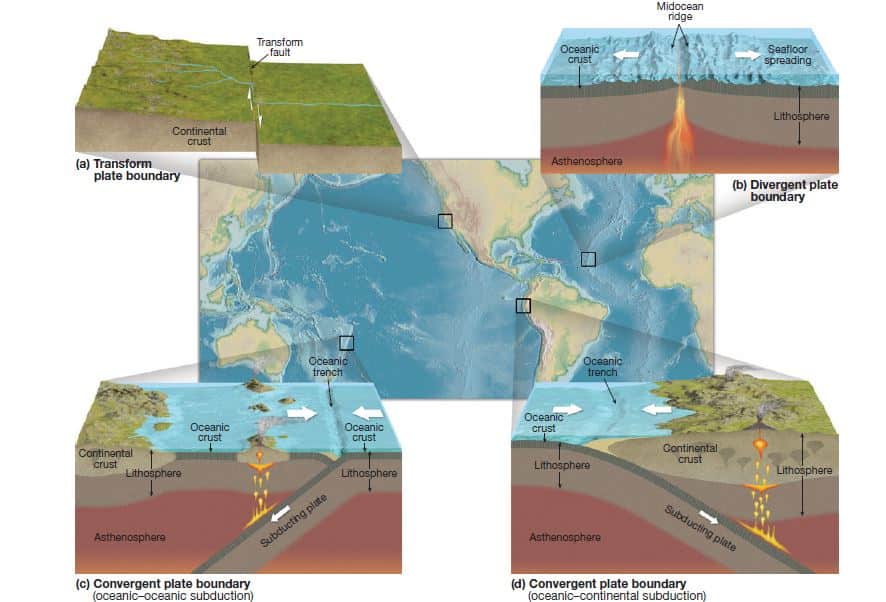
Image Explanation:- Three kinds of plate boundaries. The edges of lithospheric plates slide past each other along transform boundaries such as the San Andreas Fault system in California (a); move apart at divergent boundaries such as continental rift valleys and midocean ridges (b); and come together at convergent boundaries such as oceanic-oceanic plate subduction zones (c), oceanic continental plate subduction zones (d), and continental collision zones.
Divergent Boundaries
At a divergent boundary, magma from the asthenosphere wells up in the opening between plates. This upward flow of molten material produces a line of volcanic vents that spill out basaltic lava onto the ocean floor, with the plutonic rock gabbro solidifying deeper below.
Mid-ocean ridge
A divergent boundary is usually represented by a mid-ocean ridge. Most of the mid-ocean ridges of the world are either active or extinct spreading ridges. Such spreading centers are associated with shallow-focus earthquakes (meaning that the ruptures that generate the earthquakes are within about 70 kilometers [45 miles] of the surface), volcanic activity, and hydrothermal metamorphism—as well as the presence of remarkable marine life-forms thriving in the hostile environment of hydrothermal vents on the ocean floor. Divergent boundaries are “constructive” because material is being added to the crustal surface at such locations.
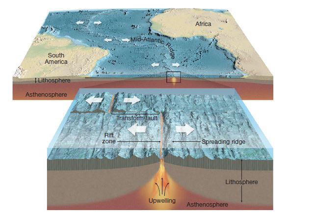
Image Explanation:- Mid-ocean ridge spreading center. Seafloor spreading involves the rise of magma from within Earth and the lateral movement of new ocean floor away from the zone of upwelling. This gradual process moves the older material farther away from the spreading center as it is replaced by newer material from below. Transform faults are found along the short offsets associated with slight bends in the ridge system.
Continental Rift Valleys
Divergent boundaries can also develop within a continent, resulting in a continental rift valley such as the Great East African Rift Valley that extends from Ethiopia southward through Mozambique. The Red Sea is also the outcome of spreading taking place within a continent—in this case the spreading has been great enough to form a “proto-ocean.”
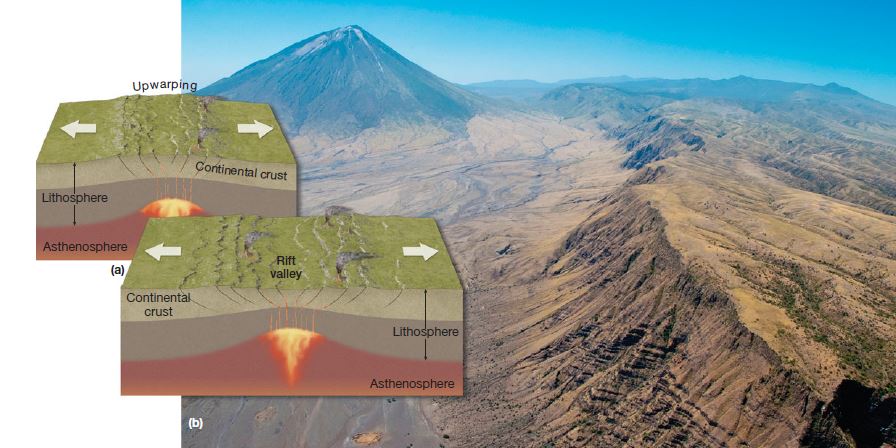
Image Explanation:- (a) A continental rift valley develops where divergence takes place within a continent. As spreading proceeds, blocks of crust drop down to form a rift valley. (b) Ol Doinyo Lengai volcano and the East African Rift Valley in Tanzania
Convergent Boundaries
At a convergent boundary, plates collide and as such are sometimes called “destructive” boundaries because they result in removal or compression of the surface crust. Convergent plate boundaries are responsible for some of the most massive and spectacular of earthly landforms: major mountain ranges, volcanoes, and oceanic trenches. The three types of convergent boundaries are: oceanic–continental convergence, oceanic–oceanic convergence, and continental–continental convergence.
Oceanic–continental Convergence
Because oceanic lithosphere includes dense basaltic crust, it is denser than continental lithosphere, and so oceanic lithosphere always underrides continental lithosphere when the two collide. The dense oceanic plate slowly and inexorably sinks into the asthenosphere in the process of subduction. The subducting slab pulls on the rest of the plate—such “slab pull” is probably the main cause of most plate movement, pulling the rest of the plate in after itself, as it were. Wherever such an oceanic–continental convergent boundary exists, a mountain range is formed on land (the Andes range of South America is one notable example; the Cascades in northwestern North America is another) and a parallel oceanic trench develops as the seafloor is pulled down by the subducting plate.
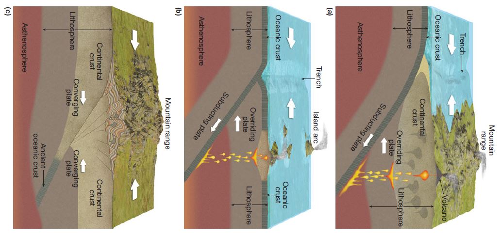
Image Explanation:- Idealized portrayals of three kinds of convergent plate boundaries: (a) Where an oceanic plate converges with a continental plate,the oceanic plate is subducted and an oceanic trench and coastal mountains with volcanoes are usually created. (b) Where an oceanic plate subducts beneath another oceanic plate, an oceanic trench and volcanic island arc result. (c) Where a continental plate collides with a continental plate subduction takes place, but mountains are generally thrust upward.
Earthquakes take place along the margin of a subducting plate. Shallow-focus earthquakes are common at the trench, but as the subducting plate descends into the asthenosphere, the earthquakes become progressively deeper, with some subduction zones generating earthquakes as deep as 600 kilometers (375 miles) below the surface. Volcanoes develop from magma generated in the subduction zone. Early researchers thought that a subducted plate would completely melt when pushed down into the hot asthenosphere. However, more recent research indicates that such a result is unlikely. Oceanic crust is relatively cold when it approaches a subduction zone and would take a long time to become hot enough to melt. A more likely explanation is that beginning at a depth of about 100 kilometers (about 60 miles) water is driven off from the oceanic crust as it is subducted, and this water reduces the melting temperature of the mantle rock above, causing it to melt. This magma rises through the overriding plate, producing both extrusive and intrusive igneous rocks. The chain of volcanoes that develops in association with an oceanic–continental plate subduction zone is sometimes referred to as a continental volcanic arc.
Such subduction zone volcanoes frequently erupt explosively. Metamorphic rocks often develop in association with subduction zones. The margin of a subducting oceanic plate is subjected to increasing pressure, although relatively modest heating, as it begins to descend—this can lead to the formation of high-pressure, low-temperature metamorphic rocks, such as blueschist. In addition, the magma generated in the subduction zone may cause contact metamorphism as it rises through the overlying continental rocks.
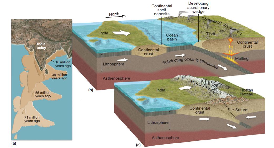
Image explanation:- (a) The collision of the subcontinent of India with Eurasia began about 45 million years ago. (b and c) This collision and continental “suture” has uplifted the Himalayas and the Tibetan Plateau.
Oceanic–oceanic Convergence
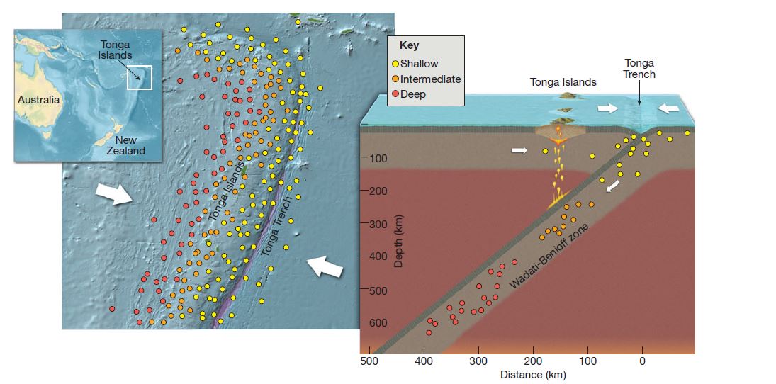
If the convergent boundary is between two oceanic plates, subduction also takes place. As one of the oceanic plates subducts beneath the other, an oceanic trench is formed, shallow- and deep-focus earthquakes occur, and volcanic activity is initiated with volcanoes forming on the ocean floor. With time, a volcanic island arc (such as the Aleutian Islands and Mariana Islands) develops; such an arc may eventually become a more mature island arc system (such as Japan and the islands of Sumatra and Java in Indonesia are today).
Image explanation:- Earthquake patterns associated with the Tonga Trench subduction zone (show in a map view on the left and a side view on the right). Shallow-focus earthquakes occur where the Pacific Plate begins to subduct at the trench. Intermediate- and deep-focus earthquakes occur as the subducting oceanic plate goes deeper into the asthenosphere below. The Wadati–Benioff Zone is named for seismologists Kigoo Wadati and Hugo Benioff, who were the first scientists to describe these inclined zones of earthquakes.
Continental–continental Convergence:
Where there is a convergent boundary between two continental plates, no subduction takes place because continental crust is too buoyant to subduct. Instead, huge mountain ranges, such as the Alps, are built up. The most dramatic present-day example of continental collision has resulted in the formation of the Himalayas.
The Himalayas began to form more than 45 million years ago, when the subcontinent of India started its collision with the rest of Eurasia. Under the conditions of continental collision, volcanoes are rare, but shallow-focus earthquakes and regional metamorphism are common.
Transform Boundaries
At a transform boundary, two plates slip past one another laterally. This slippage occurs along great vertical fractures called transform faults. Because the plate movement is basically parallel to a transform boundary, these boundaries neither create new crust nor destroy old. Transform faults are associated with a great deal of seismic activity, commonly producing shallow focus earthquakes.
Most transform faults are found along the mid-ocean ridge system, where they form short offsets in the ridge perpendicular to the spreading axis. However, in some places, transform faults extend for great distances, occasionally through continental lithosphere. For example, the most famous fault system in the United States, the San Andreas Fault in California, is on a transform boundary between the Pacific and North American plates 4 – 18
Plate Boundaries Over Geologic Time
Plate tectonics provides us with a grand framework for understanding the extensive lithospheric rearrangement that has taken place during the history of Earth. A brief summary of major events in Earth’s history might highlight the following:
Between about 1.1 billion and 800 million years ago—before Pangaea existed—there was an earlier supercontinent, called Rodinia by geologists.
By about 700 million years ago, Rodinia was rifting apart into continental pieces that would eventually “suture” (fuse) back together again—first into a large southern continent called Gondwana (which included present-day South America, Africa, India, Australia, and Antarctica), and later into a northern continent called Laurasia (comprised of present-day North America and Eurasia). By about 250 million years ago, Gondwana and Laurasia had joined to form Pangaea.
About 200 million years ago, when Pangaea was beginning to rift apart, there was only one largely uninterrupted ocean.
By 90 million years ago, continental fragmentation was well under way. The North Atlantic Ocean was beginning to open, and the South Atlantic began to separate South America from Africa. Antarctica is the only continent that has remained near its original position.
By 50 million years ago, the North and South Atlantic Oceans had both opened, and South America was a new and isolated continent that was rapidly moving westward. The Andes were growing as South America overrode the Pacific Ocean basin; the Rockies and the ancestral Sierra Nevada had risen in North America.
Today, South America has connected with North America. North America has separated from western Eurasia, Australia has split from Antarctica, and India has collided with Eurasia to thrust up the Himalayas. Africa is splitting along the Great Rift Valley and slowly rotating counterclockwise.
Plate Motion into the Future
If current plate movement continues, 50 million years into the future Australia will straddle the equator as a huge tropical island. Africa may pinch shut the Mediterranean, and East Africa may become a new large island like Madagascar. The Atlantic will widen while the Pacific will shrink. Southern California—perhaps along with much of the rest of the state—will slide past the rest of North America en route to its ultimate destiny in the Aleutian Trench in the Gulf of Alaska.
One of the great triumphs of the theory of plate tectonics is that it explains broad topographic patterns. It can account for the formation of many cordilleras(groups of mountain ranges), mid-ocean ridges, oceanic trenches, island arcs, and the associated earthquake and volcanic zones. Where these features appear, there are usually plates either colliding or separating. Perhaps nowhere in the world are the consequences of tectonic and volcanic activity associated with plate boundaries more vividly displayed than around the rim of the Pacific Ocean.
Remaining Unanswered Questions
Plate tectonic theory has advanced our understanding of the internal processes of Earth dramatically. However, a number of questions remain unanswered for the time being. For example, several major mountain ranges in North America and Eurasia are in the middle of plates rather than in boundary zones. Although the genesis of some midplate ranges, such as the Appalachians in North America and the Ural Mountains in Eurasia, can be traced to continental collisions in the geologic past, other midplate mountain ranges or regions of seismic activity are not yet fully understood.
Further, although convection of heated material within the mantle provides the general mechanism for plate movement, the details of heat flow within Earth and the possible relationships of mantle plumes to these overall patterns are still being worked out.
Our present state of knowledge about plate tectonics, however, is ample to provide a firm basis for understanding the patterns of most of the world’s major relief features:-
The size, shape, and distribution of the continents,
Major mountain ranges, and
Ocean basins.
To understand more localized topographic features, however, we must now turn to less spectacular, but no less fundamental, internal processes that are often directly associated with tectonic movement.