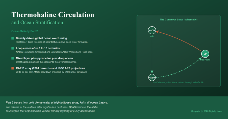
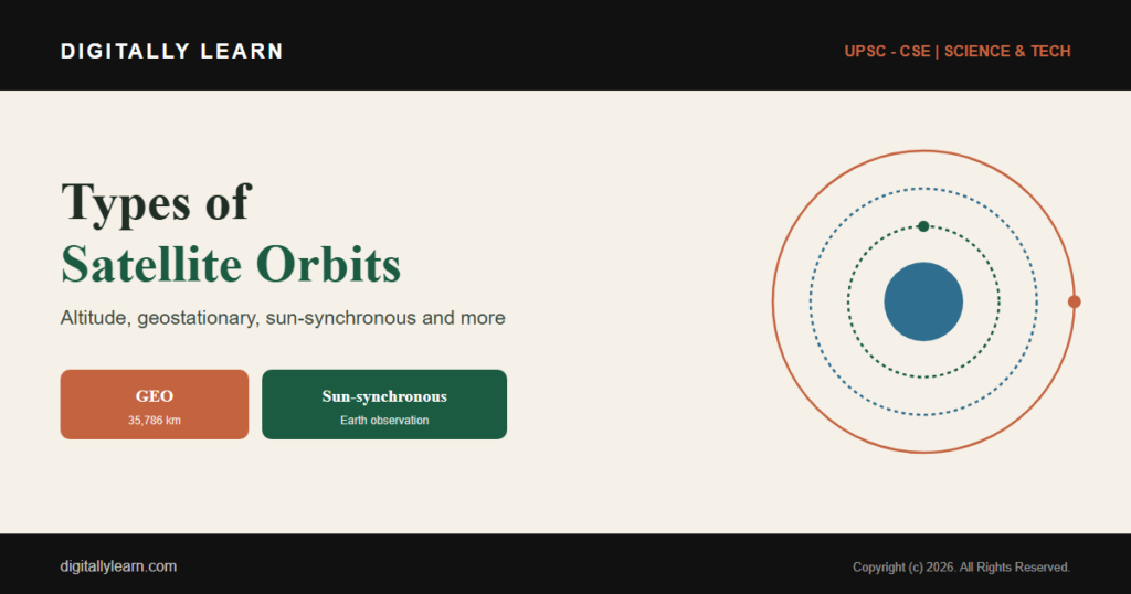
All Types of satellite orbits and their features

All Types of satellite orbits and their features | UPSC - IAS

Types of satellite orbits and their features | UPSC – IAS

When the satellite is moving in the orbits, it stays in position because the centripetal force on the satellite balances the gravitational attractive force of the earth. This balance depends on the following:

  • Distance from the earth
  • Tangential speed of the satellite
  • Earth’s radius
  • Gravitational force of the earth. But it does not depend upon:
  • Mass of the satellite
  • Size of the Satellite

There are three major types of orbits viz. :-

  • Polar orbit – A polar orbit is one in which a satellite passes above or nearly above both poles of the body being orbited on each revolution. It therefore has an inclination of 90 degrees to the body’s equator.
  • Inclined orbit- A satellite is said to occupy an inclined orbit around Earth if the orbit exhibits an angle other than 0° to the equatorial plane.
  • Near-Equatorial orbit- A near-equatorial orbit is an orbit that lies close to the equatorial plane of the object orbited. Such an orbit has an inclination near 0°.

About Geostationary Orbit (GEO) | UPSC – IAS

A geostationary orbit, also referred to as a geosynchronous equatorial orbit (GEO), is a circular geosynchronous orbit 35,786 kilometres (22,236 miles) above Earth’s equator and following the direction of Earth’s rotation.
  • If we need a satellite for the purpose which needs this satellites to remain at a particular distance from earth at all the time, then we need circular orbits so all the points on circular orbit are at equal distance from earth’s surface. The circular equatorial orbit is exactly in the plane of equator on the earth.
  • If the satellite is moving in the circular-equatorial orbit and its angular velocity is equal to earth’s angular velocity, the satellite is said to be moving along with the earth. This satellite would appear stationary from the earth and this orbit would be called Geostationary Orbit.

About Geostationary Orbit (GEO) | UPSC - IAS

Features of Geostationary Orbits

  • The orbit is circular
  • The orbit is in equatorial plane i.e. directly above the equator and thus inclination is zero.
  • The angular velocity of the satellite is equal to angular velocity of earth
  • Period of revolution is equal to period of rotation of earth.
  • Finish one revolution around the earth in exactly one day i.e. 23 hours, 56 Minutes and 4.1 seconds
  • There is ONLY one geostationary orbit.

About Geosynchronous Orbit | UPSC – IAS

There is a difference between the geostationary and geosynchronous orbits. We should note that while other orbits may be many, there is ONLY ONE Equatorial orbit, i.e. the orbit which is directly above the earth’s equator. Sometimes we send a satellite in the space which though has a period of revolution is equal to period of rotation of earth, but its orbit is neither equatorial nor Circular.

  • So, this satellite will finish one revolution around the earth in exactly one day i.e. 23 hours, 56 Minutes and 4.1 seconds, yet it does NOT appear stationary from the earth.
  • It looks oscillating but NOT stationary and that is why it is called Geosynchronous. So, the main features of a geosynchronous satellite are as follows:-

Features of Geosynchronous Orbits-

  • The orbit is NOT circular
  • The orbit is NOT in equatorial plane i.e. directly above the equator, it’s in inclined orbit
  • The angular velocity of the satellite is equal to angular velocity of earth
  • Period of revolution is equal to period of rotation of earth.
  • Finish one revolution around the earth in exactly one day i.e. 23 hours, 56 Minutes and 4.1 seconds
  • There are many geosynchronous orbits.

Note – that it is practically NOT possible to achieve an absolute geostationary orbit. So, the terms geostationary and geosynchronous are used alternatively.

Advantages of GEO satellites

  • Most communications satellites in use today for commercial purposes are placed in the geostationary orbit, because one satellite can cover almost 1/3 of Earth’s surface, offering a reach far more extensive than what any terrestrial network can achieve.
  • The geosynchronous satellites remain stationary over the same orbital location, users can point their satellite dishes in the right direction, without costly tracking activities, making communications reliable and secure
  • Because of their capacity and configuration, GEOs are often more cost-effective for carrying high-volume traffic, especially over long-term contract arrangements. For example, excess capacity on GEO systems often is reserved in the form of leased circuits for use as a backup to other communications methods.
  • GEO systems have significantly greater available bandwidth than the Low Earth Orbit -LEO and Medium Earth Orbit – MEO systems. This permits them to provide two-way data, voice and broadband services that may be impractical for other types of systems.
  • GEO satellites are proven, reliable and secure – with a lifespan of 10-15 years.

Altitude of Geostationary Orbit

  • In Geostationary Orbit, the satellite moves with an orbital speed of 11068 km per hours.
  • A minimum of three satellites are needed to cover the entire earth.
  • Super synchronous orbit is a disposal / storage orbit above GSO. From earth, they would seem drifting in westerly direction.
  • Sub synchronous orbit is a orbit close to but below GSO and is used for satellites undergoing station, changes in an eastern direction.

About Low Earth Orbits | UPSC – IAS

A low Earth orbit is an Earth-centred orbit with an altitude of 2,000 km or less, or with at least 11.25 periods per day and an eccentricity less than 0.25. Most of the artificial objects in outer space are in Low Earth Orbit (LEO). The International Space Station is in a LEO that varies from 320 km to 410 km above the Earth’s surface.

  • A satellite can also be placed in orbits below the Geostationary orbit, however, it will require higher orbital velocity. For example, a satellite which is placed in an orbit at altitude of 200 kilometers will need an orbital velocity of approximately 29,000 kilometer per hour.
  • Similarly, a satellite placed in an orbit at around 1730 kilometers will need a speed of 25,400 kilometers per hour.
  • LEO systems fly about 1,000 kilometers above the Earth (between 400 miles and 1,600 miles) and, unlike GEOs, they appear travelling across the sky from earth.
  • A typical LEO satellite takes 1 and half hours to orbit the Earth, which means that a single satellite is “in view” of ground equipment for a only a few minutes. As a consequence, if a transmission takes more than the few minutes that any one satellite is in view, a LEO system must “hand off” between satellites in order to complete the transmission.
  • In general, this can be accomplished by constantly relaying signals between the satellite and various ground stations, or by communicating between the satellites themselves using “inter-satellite links.”
  • LEO systems are designed to have more than one satellite in view from any spot on Earth at any given time, minimizing the possibility that the network will lose the transmission. Because of the fast-flying satellites, LEO systems must incorporate sophisticated tracking and switching equipment to maintain consistent service coverage.
  • The need for complex tracking schemes is minimized, but not obviated, in LEO systems designed to handle only short-burst transmissions.
  • The advantage of the LEO system is that the satellites’ proximity to the ground enables them to transmit signals with no or very little delay, unlike GEO systems. LEO satellites rotate the earth and currently deliver significant voice quality over the Geosynchronous (GEO) satellite systems.
  • Now a days, LEO Satellites are used in constellations such as Globalstar and Iridium constellations. In addition, because the signals to and from the satellites need to travel a relatively short distance, LEOs can operate with much smaller user equipment (e.g., antennae) than can systems using a higher orbit.
  • In addition, a system of LEO satellites is designed to maximize the ability of ground equipment to “see” a satellite at any time, which can overcome the difficulties caused by obstructions such as trees and buildings.

Advantages and disadvantages of Low Earth Orbit (LEO)

  • It requires less energy to place a satellite into a LEO and the LEO satellite needs less powerful amplifiers for successful transmission, LEO is still used for many communication applications.
  • However, since these LEO orbits are not geostationary, a network (or “constellation”) of satellites is required to provide continuous coverage.
  • The transmission delay associated with LEO systems is the lowest of all of the systems.
  • Because of the relatively small size of the satellites deployed and the smaller size of the ground equipment required, the LEO systems are expected to cost less to implement than the other satellite systems.
  • The small coverage area of a LEO satellite means that a LEO system must coordinate the flight paths and
    communications handoffs a large number of satellites at once, making the LEOs dependent on highly complex and sophisticated control and switching systems.
  • LEO satellites have a shorter life span than other systems. There are two reasons for this:
    • First, the lower LEO orbit is more subject to the gravitational pull of the Earth and
    • Second, the frequent transmission rates necessary in LEO systems mean that LEO satellites generally have a shorter battery life than others.

Issue of Orbital Decay in Low Earth Orbits

Decay is a gradual decrease of the distance between two orbiting bodies at their closest approach over many orbital periods. These orbiting bodies can be a planet and its satellite, a star and any object orbiting.

  • The satellites particularly in the Low Earth Orbit (LEO) are subject to a drag produced by an atmosphere due to frequent collisions between the satellite and surrounding air molecules.
  • The amount of this drag keeps increasing or decreasing depending upon several factors including the solar activity. The more activity heats of the upper atmosphere and can increase the drag.
  • This drag in a long duration causes a reduction in the altitude of a satellite’s orbit, which is called orbital decay. So, the major cause of the orbital decay is Earth’s atmosphere.
  • The result of the drag is increased heat and possible reentry of satellite in atmosphere causing it to burn. Lower its altitude drops, and the lower the altitude, the faster the decay.
  • Apart from Atmosphere, the Tides can also cause orbital decay, when the orbiting body is large enough to raise a significant tidal bulge on the body it is orbiting and is either in a retrograde orbit or is below the synchronous orbit. Mars’s moon Phobos is one of the best examples of this.

About Medium Earth Orbit (MEO) | UPSC – IAS

Medium Earth orbit (MEO), sometimes called intermediate circular orbit, is the region of space around Earth above low Earth orbit and below geosynchronous orbit. Unlike the circular orbit of the geostationary satellites, MEO’s are placed in an elliptical (oval-shaped) orbit.

  • Medium Earth Orbit (MEO) systems operate at about 8,000-20,000 km above the Earth, which is lower than the GEO orbit and higher than most LEO orbits.
  • The MEO orbit is a compromise between the LEO and GEO orbits. Compared to LEOs, the more distant orbit requires fewer satellites to provide coverage than LEOs because each satellite may be in view of any particular location for several hours.
  • Compared to GEOs, MEOs can operate effectively with smaller, mobile equipment and with less latency (signal delay). These orbits are primarily reserved for communications satellites that cover the North and South Pole.
  • Although MEO satellites are in view longer than LEOs, they may not always be at an optimal elevation. To combat this difficulty, MEO systems often feature significant coverage overlap from satellite to satellite, which in turn requires more sophisticated tracking and switching schemes than GEOs.
  • Typically, MEO constellations have 10 to 17 satellites distributed over two or three orbital planes. Most planned MEO systems will offer phone services similar to the Big LEOs. In fact, before the MEO designation came into wide use,
  • MEO systems were considered Big LEOs. Examples of MEO systems include – ICO Global Communications and the proposed Orblink from Orbital Sciences.
  • The orbit is home to a number of artificial satellites – the most common uses include navigation, communication, and geodetic/space environment science.

About Polar Orbits | UPSC – IAS

A polar orbit is one in which a satellite passes above or nearly above both poles of the body being orbited on each revolution. It therefore has an inclination of 90 degrees to the body’s equator

The Polar Orbit is not much suitable for communication purposes because it moved in a different direction than that of direction of earth’s rotation. So, the use of Polar satellites depends upon their arrival at a particular point on earth at a particular point. The Polar orbits are used for special applications like navigational satellites.

Features of Polar Orbits

  • Except for polar geosynchronous orbit, a satellite in a polar orbit will pass over the equator at a different longitude on each of its orbits.
  • No one spot on the Earth’s surface can be sensed continuously from a satellite in a polar orbit, this is its biggest drawback.
  • The polar orbit can be manipulated also. If we want a satellite in polar orbit to remain hovering over a certain area for larger time, it can be placed in a highly elliptical orbit with its apogee over that area.
  • In a polar orbit, the satellite passes above or nearly above both poles of the earth being orbited on each revolution. So, we can say that the inclination of such orbit is almost 90 degrees to the equator.

The Polar orbits are used for – earth-mapping, earth observation, and reconnaissance satellites, as well as for some weather satellites. However, Iridium satellite constellation also uses a polar orbit to provide telecommunications services.

Why Polar orbits are used for earth-mapping ?

Polar orbits are in a plane that is almost perpendicular to the plane of the equator and so passes over the poles of the Earth and then also, Earth rotates from East to West under the satellite. For instance, if the period of satellite is 6 hours then in one polar revolution, earth will rotate around 90° westwards. Thus, in a couple of days the whole earth can be mapped.

About Inclined Orbit | UPSC – IAS

  • An inclined orbit is used to cover the Polar Regions. It’s not a very popular orbit and used not very frequently. The height of the inclined orbit is kept such that it covers the required area of the region of interest. The time for which the satellite is visible to the point on the earth is also controlled.
  • Satellite cannot remain in continuous contact with the point on the earth if rotating in inclined orbit. Sometimes the inclined orbit is also called elliptical inclined orbit.

About Sun-synchronous orbit | UPSC – IAS

A Sun-synchronous orbit, also called a heliosynchronous orbit, is a nearly polar orbit around a planet, in which the satellite passes over any given point of the planet’s surface at the same local mean solar time.

  • Sun-synchronous orbit or a heliosynchronous orbit very important because of its particular importance to satellites intended for remote sensing and military applications.
  • A sun-synchronous orbit is one that lies in a plane that maintains a fixed angle with respect to the Earth-sun direction. In other words, it combines altitude and inclination in such a way that an object on that orbit ascends or descends over any given point of the Earth’s surface at the same local mean solar time.
  • We can say that the orbital plane in such a case has a fixed orientation with respect to the Earth-sun direction and the angle between the orbital plane and the Earth-sun line remains constant throughout the year.

Features of Sun Synchronous Orbits

  • The satellite passes over a given location on Earth every time at the same local solar time.
  • Thus, it guarantees the same illumination condition, which varies only with seasons.
  • The orbit is Quasi-polar in nature and so ensures coverage of the whole surface of the Earth
  • Every time a sun-synchronous satellite completes one revolution around earth, it traverses a thin strip on the surface of the Earth. During the next revolution it traverses another strip.

About Frozen Orbits | UPSC – IAS

A frozen orbit is an orbit for an artificial satellite in which natural drifting due to the central body’s shape has been minimized by careful selection of the orbital parameters. Typically, this is an orbit in which, over a long period of time, the satellite’s altitude remains constant at the same point in each orbit.

  • We all know that Earth is not perfectly round. This means the gravitation is not exactly same at all the places. Apart from that there is gravitational pull from Sun and Moon too, followed by the solar radiation pressure, air drag and so many other forces.
  • In other words, most satellites experience noticeable variations in orbital eccentricity (orbit’s eccentricity is a way of measuring how much the orbit deviates from a perfect circle).
  • But, fortunately, the distorting impacts of these issues can be induced to cancel each other by expert satellite planners. They choose optimum Orbital altitude, inclination, eccentricity and argument of perigee. The satellites whose orbital parameters are controlled by such techniques is said to be in Frozen Orbits.
  • Thus we can say that:- Frozen orbit is a Sun-synchronous orbit in which the precession of the orbital plane around the polar axis of the Earth caused by the oblateness of the Earth is utilized to the benefit of the mission by choosing correct orbital parameters.
  • The Earth observation satellites European Remote Sensing satellite (ERS) -1, European Remote Sensing satellite (ERS) -2 and Envisat are all operated in Sun-synchronous “frozen” orbits.

About Clarke Orbit | UPSC – IAS

A single geostationary satellite can view approximately one third of the Earth’s surface. If three satellites are placed at the proper longitude, the height of this orbit allows almost the Earth’s entire surface to be covered by the satellites. It was first of all conceptualized by world famous science fiction writer Arthur C. Clarke.

The stations would be arranged approximately equidistantly around the earth and the following longitudes appear suitable:

  • 30°E – Africa & Europe
  • 150°E – China & Oceania
  • 90° W– The Americas

The station chain would be linked by radio or optical beams and thus any broadcast service could be provided. The geostationary orbit is now sometimes referred as the Clarke Orbit or the Clarke Belt in his honor.

About Highly elliptical orbit (HEO) | UPSC – IAS

About Highly elliptical orbit (HEO) | UPSC - IAS

  • A highly elliptical orbit is an elliptic orbit with high eccentricity, usually referring to one around Earth. Examples of inclined HEO orbits include Molniya orbits, named after the Molniya Soviet communication satellites which used them, and Tundra orbits.
  • Highly Elliptical Orbits (HEOs) about the Earth are often selected for astrophysics and astronomy missions, as well as for Earth missions, such as Molniya or Tundra orbits, as they offer vantage point for the observation of the Earth and the Universe.

Other types of Orbit | UPSC – IAS

  • Super synchronous orbit is a disposal / storage orbit above GSO. From earth, they would seem drifting in westerly direction.
  • Sub synchronous orbit is a orbit close to but below GSO and is used for satellites undergoing station, changes in an eastern direction.
  • Graveyard orbit is a Supersynchronous orbit where spacecraft are intentionally placed at the end of their operational life.

Leave a Comment