
Overview
Previous Year Questions By the end of this article you will be able to draft model answers for the following UPSC questions. Each question carries a collapsible framework showing how to approach it in the exam.
- UPSC Prelims 2015 General Studies: Consider the following States:
- Arunachal Pradesh
- Himachal Pradesh
- Mizoram
In which of the above States do 'Tropical Wet Evergreen Forests' occur?
How to approach this Prelims question
Approach: State-by-state evaluation against the Champion-Seth Group 1A climatic criteria (rainfall above 2,500 mm, temperature above 22 C, dry season under 3 months). Arunachal Pradesh and Mizoram meet the criteria; Himachal Pradesh does not.
Trap to watch: Aspirants may assume Himachal Pradesh hosts wet evergreen forests because it has hill geography and high rainfall locally. The trap is that Himachal Pradesh's elevation places it in the sub-tropical or montane-temperate zones, not the tropical zone. Climate-zone classification is altitude-and-temperature-controlled, not rainfall-controlled alone.
Key facts to recall:
- Tropical Wet Evergreen criteria: rainfall >2,500 mm, temperature >22 C, dry season <3 months.
- Indian Tropical Wet Evergreen distribution: Western Ghats windward (Kerala, Karnataka, Tamil Nadu), north-east (Arunachal Pradesh, Mizoram, Nagaland), Andaman and Nicobar Islands.
- Himachal Pradesh forest types: Sub-tropical Pine (chir pine), Himalayan Moist Temperate (deodar, blue pine), Sub-Alpine, Alpine; NOT tropical.
Answer signal: (c) 1 and 3 only
- UPSC Prelims 2023 General Studies: Consider the following trees:
- Jackfruit (Artocarpus heterophyllus)
- Mahua (Madhuca indica)
- Teak (Tectona grandis)
How many of the above are deciduous trees?
How to approach this Prelims question
Approach: Species-by-species ecology evaluation. Determine whether each tree sheds leaves seasonally (deciduous) or retains them year-round (evergreen). Mahua and Teak are both Tropical Deciduous species (Moist Deciduous for Teak, Dry Deciduous for Mahua); Jackfruit is evergreen.
Trap to watch: Aspirants may assume Jackfruit is deciduous because it grows in the same broad climatic zone as Teak. The trap is that climatic zone alone does not determine deciduousness; species-specific phenology matters. Jackfruit is evergreen with continuous canopy.
Key facts to recall:
- Jackfruit (Artocarpus heterophyllus): evergreen; tropical wet evergreen and homestead orchards.
- Mahua (Madhuca indica): deciduous; Tropical Dry Deciduous (Group 5); minor forest produce.
- Teak (Tectona grandis): deciduous; Tropical Moist Deciduous (Group 3); commercially valuable timber.
Answer signal: (b) Only two
- UPSC Mains 2019 GS-I: Discuss the causes of depletion of mangroves and explain their importance in maintaining coastal ecology.
How to structure the answer in the exam
Introduction: Open by stating that Indian mangrove cover spans 4,991.68 sq km across nine coastal states per ISFR 2023, with the Sundarbans at the Ganga-Brahmaputra-Meghna delta forming the largest contiguous block. Note the approximately 30 per cent decline since the 1970s and the multiple anthropogenic and climatic drivers.
Body (sub-themes to develop):
- Depletion cause: aquaculture conversion: shrimp-farm pond construction has destroyed approximately 25 per cent of Indian mangrove cover since 1980, particularly along the Andhra Pradesh and West Bengal coasts.
- Depletion cause: infrastructure expansion: port construction (Mundra in Gujarat, Krishnapatnam in Andhra Pradesh), jetty development, and coastal urbanisation of Mumbai, Chennai, Visakhapatnam.
- Depletion cause: hydrological alteration: upstream dam construction reduces freshwater discharge needed for brackish-water balance; the Farakka Barrage on the Ganga has measurably affected Sundarbans salinity.
- Depletion cause: pollution: industrial effluents, agrochemical runoff, and oil spills from coastal shipping; pesticide-bioaccumulation in mangrove fish.
- Depletion cause: climate change: sea-level rise threatens low-elevation mangrove submergence; cyclone intensification damages canopy; ocean acidification stresses mangrove physiology.
- Coastal-ecology importance: shoreline stabilisation: aerial-root mat traps sediment and reduces coastal erosion; protects coastlines against storm-surge damage; mangrove canopy attenuated 2004 tsunami impact along Tamil Nadu and Andhra Pradesh coasts.
- Coastal-ecology importance: fisheries nursery: 80 per cent of Indian Ocean commercial fish species spawn or feed in mangroves; mangrove-supported fisheries sustain approximately 5 million Indian coastal-community livelihoods.
- Coastal-ecology importance: blue-carbon sequestration: mangroves sequester carbon at 3 to 5 times the per-hectare rate of terrestrial forests; Indian mangroves stock approximately 67 million tonnes of carbon.
- Coastal-ecology importance: biodiversity habitat: Royal Bengal tiger (Sundarbans), saltwater crocodile (Bhitarkanika), spotted deer, fishing cat, mangrove pitta, and endemic mollusc-and-crustacean fauna.
- Conservation framework: CRZ-IA designation under CRZ Notification 2019; Sundarbans Tiger Reserve under Wildlife Protection Act 1972; MISHTI (2023) commits 540 sq km restoration; Ramsar designation for 7 Indian mangrove sites.
Conclusion: Conclude by noting that mangrove depletion driven by aquaculture, infrastructure, hydrology, pollution, and climate change is reversible only through integrated policy action. The MISHTI commitment of 540 sq km restoration, the CRZ-IA designation, and the strengthened Wildlife Protection Act enforcement together form the contemporary mitigation framework. Mangroves' coastal-ecology services in shoreline stabilisation, fisheries nursery, blue-carbon sequestration, and biodiversity habitat make their restoration a multi-objective public good.
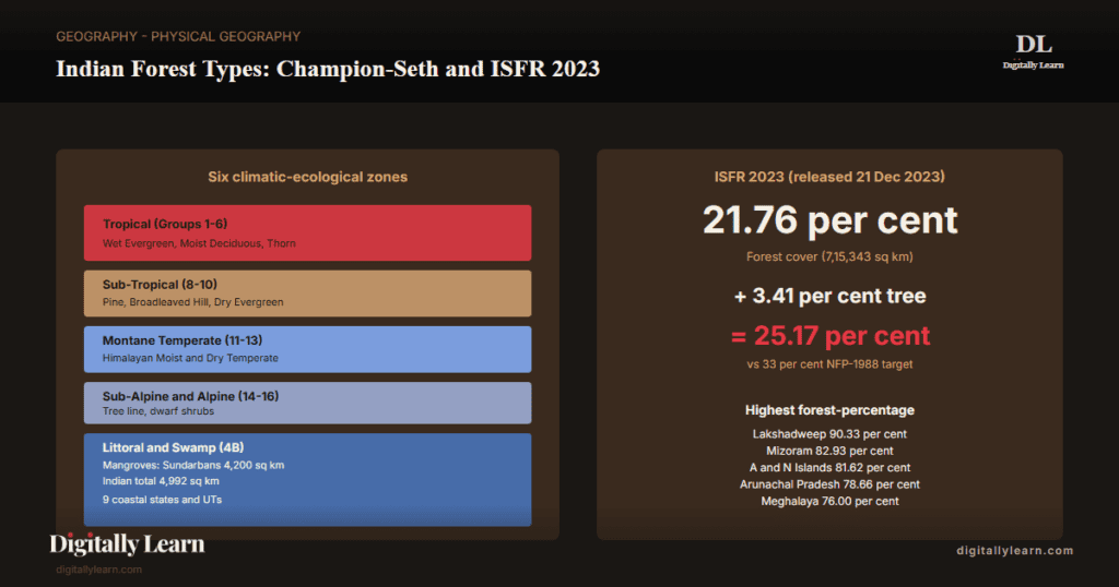
The Indian forest typology follows the classification scheme developed by H. G. Champion and S. K. Seth (1968) in their Revised Survey of the Forest Types of India. The scheme recognises 16 major forest type groups further divided into 221 type subgroups across six climatic-ecological zones: tropical, sub-tropical, montane temperate, sub-alpine, alpine, and littoral-swamp. Total forest cover stands at approximately 21.76 per cent of India's geographical area per the India State of Forest Report 2023, with tropical moist deciduous and tropical dry deciduous forests together accounting for over 60 per cent of the recorded forest area. The classification anchors the operational forest management framework under the Indian Forest Act 1927 and the Forest Conservation Act 1980.
Background and Historical Context
India's forests sustain the country's water cycle, biodiversity, carbon stock, and tribal livelihoods. The 21.76 per cent recorded forest cover anchors India's Nationally Determined Contribution commitment to create an additional carbon sink of 2.5 to 3 billion tonnes of CO2-equivalent through forest and tree cover by 2030. Approximately 275 million people depend on forests for fuelwood, fodder, minor forest produce, and seasonal employment. UPSC Prelims questions on forest types and Indian biogeography have appeared in 2008, 2010, 2011, 2014, 2015, 2017, 2022, and 2023. UPSC GS-I Mains anchors on forest geography and biogeography; GS-III anchors on the Forest Conservation Act, CAMPA, and contemporary forest-policy controversies.
What is the significance of mastering the Champion-Seth classification? The scheme integrates climate, soil, and altitude into a single ecological framework that maps directly to species distribution, fire regimes, regeneration ecology, and management strategy. Mastering the classification allows reasoning from a single observation (a species, a soil type, an elevation band) to the expected forest type. The same framework explains why Sundarbans mangroves exist only along the Bay of Bengal delta, why shola grasslands are confined to the Western Ghats above 1,500 metres, why chir pine dominates the lower Himalayan sub-tropical belt, and why tropical wet evergreen forests are restricted to Arunachal Pradesh, Mizoram, the Andaman Islands, and the Western Ghats windward slopes.
The Forest Survey of India (FSI) publishes the biennial India State of Forest Report (ISFR), with the 2023 edition reporting total forest cover at 7,15,343 square kilometres or 21.76 per cent of geographical area (with tree cover an additional 3.41 per cent). The Forest Conservation (Amendment) Act 2023 renamed the parent Act as Van (Sanrakshan Evam Samvardhan) Adhiniyam and narrowed the definition of forest to recorded forest, dropping the 1996 T. N. Godavarman Supreme Court directive's dictionary-meaning interpretation. Mission LiFE announced 2022 and the Green India Mission (GIM) launched 2014 form the policy umbrella for afforestation; the CAMPA fund, statutorily anchored under the Compensatory Afforestation Fund Act 2016, channels approximately Rs 56,000 crore for compensatory afforestation across states.
Introduction: The Champion-Seth Classification Framework
From Champion 1936 to Champion-Seth 1968
The first systematic classification of Indian forests was developed by Harry George Champion, the British forester and conservator of forests for the United Provinces, in his 1936 monograph A Preliminary Survey of the Forest Types of India and Burma. Champion's 1936 scheme recognised five major climatic-ecological groups: tropical, sub-tropical, montane temperate, sub-alpine, and alpine, with the littoral-swamp group added separately.
The classification was substantially revised and extended by Champion in collaboration with S. K. Seth, the Indian Forest Service officer who succeeded Champion as the leading authority on Indian biogeography.
The revised 1968 monograph A Revised Survey of the Forest Types of India, published by the Manager of Publications, Government of India, New Delhi, has remained the operational standard for the Forest Survey of India and the state forest departments. The 1968 revision recognises 16 major type groups further divided into 221 type subgroups.
The six climatic-ecological zones of the Champion-Seth scheme
The Champion-Seth classification organises India's forest cover across six climatic-ecological zones defined by temperature, rainfall, and altitude. Each zone hosts a coherent set of forest type groups that share regeneration ecology, fire regime, and management requirements.
- Tropical zone: Type groups 1 to 6, covering the bulk of peninsular India and the Indo-Gangetic plain; rainfall 50 to 6,000 mm; temperature 25 to 35 C; elevation 0 to 1,000 metres.
- Sub-tropical zone: Type groups 8 to 10, covering the lower Himalayan slopes and the Khasi-Jaintia-Naga hills; rainfall 1,000 to 3,000 mm; elevation 1,000 to 1,800 metres.
- Montane temperate zone: Type groups 11 to 13, covering the middle and upper Himalayan slopes; rainfall 600 to 2,500 mm; elevation 1,800 to 3,500 metres.
- Sub-alpine zone: Type group 14, covering the upper Himalayan slopes just below the tree line; elevation 3,000 to 3,800 metres.
- Alpine zone: Type groups 15 to 16, covering the high Himalayan slopes above the tree line; rainfall variable; elevation 3,500 to 5,500 metres.
- Littoral and swamp zone: Type group 4B in the scheme, covering coastal mangroves and inland marshy areas; geographic distribution along all Indian coasts plus the Sundarbans delta.
Tropical Forests: Groups 1 to 6 (60 Per Cent of Indian Forest Area)
Tropical Wet Evergreen Forests (Group 1A)
Tropical Wet Evergreen Forests (Champion-Seth Group 1A) require annual rainfall above 2,500 millimetres, mean annual temperature above 22 degrees Celsius, and a dry season shorter than three months. The canopy is dense, multi-tiered, and evergreen. Tree heights reach 45 to 60 metres in the emergent layer; lianas, epiphytes, and stranglers are abundant; the forest floor is dim and humid year-round.
- Characteristic species: Mesua ferrea (ironwood), Dipterocarpus indicus, Hopea parviflora, Palaquium ellipticum, Cullenia exarillata.
- Rainfall threshold: Above 2,500 millimetres annually; usually above 3,000 mm.
- Geographical distribution: Western Ghats windward (Kerala, Karnataka, Tamil Nadu), north-east India (Arunachal Pradesh, Mizoram, Nagaland), Andaman and Nicobar Islands.
- Soil association: Lateritic and red-loamy soils on the Western Ghats windward; deep alluvium in north-east.
- Conservation status: Highest priority; included in Western Ghats UNESCO World Heritage natural site (2012) and Andaman biosphere reserves.
Tropical Moist Deciduous (Group 3) and Tropical Dry Deciduous (Group 5)
Tropical Moist Deciduous Forests (Group 3) cover the largest area of Indian forest, spanning Madhya Pradesh, Chhattisgarh, Jharkhand, Odisha, eastern Maharashtra, and the Himalayan foothills. Annual rainfall is 1,000 to 2,000 millimetres; trees shed their leaves for 6 to 8 weeks in the dry season; the canopy is closed and the understory supports commercially-valued species. Sal (Shorea robusta) is the dominant species across central and eastern India; teak (Tectona grandis) dominates the western and southern Indian Moist Deciduous belt.
Tropical Thorn (Group 6) and Tropical Semi-Evergreen (Group 2)
Tropical Thorn Forests (Group 6) occur in the most arid zones with annual rainfall under 700 millimetres: western Rajasthan, Saurashtra-Kutch, southern Punjab and Haryana, the rain-shadow tracts of Karnataka and Andhra Pradesh. The canopy is open and discontinuous; species are xerophytic with thorns, small leaves, and deep root systems. Characteristic species include Acacia nilotica (babool), Prosopis cineraria (khejri), Capparis decidua (kair), and Ziziphus mauritiana (ber).
Sub-Tropical, Montane Temperate, Sub-Alpine, and Alpine Forests
Sub-Tropical Pine and Sub-Tropical Broadleaved Forests (Groups 8 and 9)
Sub-Tropical Pine Forests (Group 8) cover the lower Himalayan belt at elevations of 1,000 to 1,800 metres in Jammu and Kashmir, Himachal Pradesh, Uttarakhand, Arunachal Pradesh, and Manipur. The dominant species is Pinus roxburghii (chir pine), a long-needled pine that thrives on dry south-facing slopes. Chir-pine forests are fire-adapted and economically important for resin tapping. Mixing with broadleaved species occurs at the lower altitude limit.
Sub-Tropical Broadleaved Hill Forests (Group 9) cover the lower hills of the north-east Indian belt: Meghalaya, Mizoram, Manipur, Nagaland, and the lower hills of Arunachal Pradesh. Rainfall is high (above 2,000 millimetres) and the species composition is dominated by oaks, chestnuts, and laurels. Cherrapunji and Mawsynram fall within this zone at the lower elevation band.
Himalayan Moist Temperate (Group 11) and Himalayan Dry Temperate (Group 13)
Himalayan Moist Temperate Forests (Group 11) cover the middle Himalayan slopes at elevations of 1,500 to 3,300 metres, primarily on the windward south-facing aspect. Dominant species are Cedrus deodara (deodar), Pinus wallichiana (blue pine), Picea smithiana (West Himalayan spruce), Abies pindrow (West Himalayan fir), and Quercus semecarpifolia (kharsu oak). The deodar belt of Himachal Pradesh and Uttarakhand is the highest-value timber resource in the Indian montane forests.
Himalayan Dry Temperate Forests (Group 13) cover the inner Himalayan slopes in the rain-shadow zones of Ladakh, the Spiti and Lahaul valleys of Himachal Pradesh, and the upper Kinnaur. Annual rainfall falls under 600 millimetres; species are xeric pines and junipers. Distribution corresponds to the trans-Himalayan tract beyond the Greater Himalayan rainfall divide.
Sub-Alpine (Group 14) and Alpine Forests (Groups 15 and 16)
Sub-Alpine Forests (Group 14) occupy the narrow elevation band of 3,000 to 3,800 metres in the Himalayas, just below the tree line. The canopy thins; species are Abies spectabilis (silver fir), Betula utilis (Himalayan birch), Rhododendron campanulatum, and stunted forms of Pinus wallichiana.
Above 3,800 metres the tree line gives way to moist alpine scrub (Group 15) and dry alpine scrub (Group 16), dominated by dwarf shrubs, herbs, and grasses; the Western Himalayan alpine meadows of Kashmir and Uttarakhand (Valley of Flowers, Tungnath, Auli) sit in this zone.
Littoral and Swamp Forests: Mangroves and the 2019 Mains Question
Mangrove ecology, Indian distribution, and Sundarbans dominance
Mangrove forests (Champion-Seth Group 4B littoral-swamp) are the salt-tolerant tropical forests of inter-tidal coastal zones. Mangrove species are characterised by pneumatophores (aerial breathing roots), vivipary (seed germination on the parent tree), and salt-secretion or salt-exclusion mechanisms at the leaves. Mangroves provide the canonical ecosystem-service bundle: shoreline stabilisation, fisheries nursery, carbon sequestration (blue-carbon), cyclone-storm-surge attenuation, and habitat for endemic fauna including the Bengal tiger of the Sundarbans.
Indian mangrove distribution per ISFR 2023 totals 4,991.68 square kilometres across nine coastal states and union territories. The largest contiguous block is the Sundarbans (4,200 sq km in India and 6,500 sq km in Bangladesh) at the Ganga-Brahmaputra-Meghna delta, recognised as a UNESCO World Heritage natural site and as a Ramsar wetland. Other significant Indian mangrove tracts occur in Gujarat (Kachchh and Gulf of Khambhat), Andhra Pradesh (Godavari and Krishna deltas), Odisha (Bhitarkanika), Andaman and Nicobar Islands, and Maharashtra-Goa-Karnataka-Kerala coasts.
- Sundarbans: 4,200 sq km Indian portion; dominant species Heritiera fomes (sundri), Bruguiera, Rhizophora, Avicennia, Excoecaria; Royal Bengal tiger habitat.
- Gujarat: 1,177 sq km; Kachchh and Gulf of Khambhat; dominant species Avicennia marina (grey mangrove).
- Andhra Pradesh: 405 sq km; Krishna and Godavari deltas; dominant species Excoecaria agallocha, Avicennia officinalis.
- Odisha (Bhitarkanika): 259 sq km; UNESCO biosphere reserve; saltwater crocodile habitat.
- Andaman and Nicobar Islands: 616 sq km; least-disturbed Indian mangroves with high endemism.
- Maharashtra: 320 sq km; coastal regulation zone enforcement; Thane Creek and Sindhudurg.
Mangrove depletion causes and conservation policy
Mains 2019 tested mangrove-depletion causes and coastal-ecology importance. The depletion drivers fall into four categories.
- First: Direct conversion: aquaculture-pond construction (shrimp farming has destroyed 25 per cent of Indian mangrove cover since 1980), port-and-jetty infrastructure expansion, urbanisation of coastal cities (Mumbai, Chennai, Visakhapatnam).
- Second: Hydrological alteration: upstream dam construction reduces freshwater discharge needed to maintain the brackish-water balance; the Farakka Barrage on the Ganga has measurably affected Sundarbans salinity.
- Third: Pollution: industrial effluents, agrochemical runoff, and oil spills from coastal shipping.
- Fourth: Climate change: sea-level rise threatens to submerge low-elevation mangroves; cyclone intensification damages canopy; ocean acidification stresses mangrove physiology.
Conservation policy operates through multiple statutory and programmatic instruments. The Coastal Regulation Zone (CRZ) notification 2019 classifies mangroves as CRZ-IA and prohibits any developmental activity within them. The Wildlife Protection Act 1972 declares Sundarbans Tiger Reserve and Bhitarkanika National Park.
The Mangrove Initiative for Shoreline Habitats and Tangible Incomes (MISHTI) announced in the Union Budget 2023-24 commits restoration of mangroves along 540 square kilometres of Indian coast. The Ramsar Convention designates 27 Indian wetland sites of which 7 contain mangrove forests.
Forest Distribution and ISFR 2023 Statistics
ISFR 2023: national totals and state-level rankings
The India State of Forest Report 2023 (ISFR-2023), released on 21 December 2023 by the Forest Survey of India (FSI Dehradun), reports total forest cover of 7,15,343 square kilometres, equivalent to 21.76 per cent of India's geographical area. Tree cover (trees outside forests) adds an additional 1,12,014 square kilometres or 3.41 per cent.
Combined forest-plus-tree cover stands at 25.17 per cent of the geographical area, against the National Forest Policy 1988 target of 33 per cent (60 per cent in hill and mountain regions, 20 per cent in plains).
| Rank | State | Forest cover (sq km) | Percentage of state area |
|---|---|---|---|
| 1 | Madhya Pradesh | 85,724 | 27.73 per cent |
| 2 | Arunachal Pradesh | 65,882 | 78.66 per cent |
| 3 | Maharashtra | 50,798 | 16.51 per cent |
| 4 | Odisha | 52,156 | 33.50 per cent |
| 5 | Chhattisgarh | 55,717 | 41.21 per cent |
| 6 | Karnataka | 38,724 | 20.19 per cent |
| 7 | Andhra Pradesh | 29,784 | 18.28 per cent |
| 8 | Telangana | 21,214 | 18.93 per cent |
| 9 | Uttarakhand | 24,303 | 45.43 per cent |
| 10 | Mizoram | 17,470 | 82.93 per cent |
State rankings by percentage of geographical area under forest
The state rankings by percentage of geographical area under forest tell a different story from absolute area. Forest-cover percentage is highest in the small north-eastern states and the union territories with substantial mountain or island geography.
- Lakshadweep: 90.33 per cent (highest percentage); island-coconut-plantation classified as forest.
- Mizoram: 82.93 per cent (highest north-east state); tropical wet evergreen and sub-tropical broadleaved.
- Arunachal Pradesh: 78.66 per cent; tropical wet evergreen and sub-tropical pine.
- Andaman and Nicobar Islands: 81.62 per cent; tropical wet evergreen and littoral mangroves.
- Nagaland: 73.90 per cent; tropical wet evergreen and sub-tropical broadleaved.
- Meghalaya: 76.00 per cent; sub-tropical broadleaved hill forests.
- Manipur: 74.34 per cent; tropical wet evergreen and sub-tropical pine.
- Tripura: 73.68 per cent; tropical moist deciduous and sub-tropical broadleaved.
Contemporary Forest Policy Frontier: FCA Amendment 2023, CAMPA, Mission LiFE
Forest Conservation (Amendment) Act 2023: scope narrowing and constitutional challenge
The Forest Conservation (Amendment) Act 2023, enacted in August 2023 and renamed the parent 1980 Act as Van (Sanrakshan Evam Samvardhan) Adhiniyam, narrowed the working definition of forest. Under the amendment, the Act applies only to lands notified as forest under the Indian Forest Act 1927 or recorded as forest in government records. The amendment effectively reversed the 1996 T. N.
Godavarman Thirumulpad Supreme Court directive, which had extended the Act to any land falling within the dictionary meaning of forest regardless of recorded status.
The amendment also exempts certain categories from forest-clearance requirements. Distinguishing features of the 2023 exemption framework:
- (i) Defence and security-related infrastructure within 100 kilometres of the international border.
- (ii) Strategic highway projects.
- (iii) Zoo and safari development under government schemes.
- (iv) Ecotourism infrastructure with forest-area conversion under 10 hectares.
Critics including environmental lawyers and tribal-rights organisations have filed constitutional challenges before the Supreme Court arguing the narrowed definition violates the National Forest Policy 1988 and the recognition of forest rights under the Forest Rights Act 2006.
CAMPA fund and Mission LiFE: financing and behavioural-change frameworks
The Compensatory Afforestation Fund Management and Planning Authority (CAMPA), statutorily constituted under the Compensatory Afforestation Fund Act 2016, manages the accumulated compensatory-afforestation receipts collected from project proponents whose activities required forest-land diversion. The fund holds approximately Rs 56,000 crore across the National CAF (10 per cent of receipts) and the State CAFs (90 per cent), and finances compensatory afforestation, catchment-area treatment, wildlife protection, and forest infrastructure across states.
Mission LiFE (Lifestyle for Environment) announced by Prime Minister Modi at COP-27 in Sharm el-Sheikh in November 2022 anchors India's behavioural-change framework for sustainability. The Mission identifies 75 individual-action items grouped under save energy, save water, reduce single-use plastics, sustainable food systems, reduce e-waste, healthy lifestyles, and adopt sustainable lifestyles.
The forest-friendly subset includes responsible-tourism behaviour in protected areas, native-species plantation choices, and consumption reduction of forest-derived products. Green India Mission (GIM), launched 2014 under the National Action Plan on Climate Change, targets 10 million hectares of additional forest and tree cover by 2030.
Prelims MCQ practice
Each question below tests one specific concept from this article. Click to reveal the answer and a full option-wise explanation.
Q1. Consider the following statements regarding the Champion-Seth (1968) classification of Indian forest types:
- The scheme recognises 16 major forest type groups divided into 221 type subgroups.
- The scheme classifies forests across six climatic-ecological zones: tropical, sub-tropical, montane temperate, sub-alpine, alpine, and littoral-swamp.
- Tropical Wet Evergreen Forests require annual rainfall above 2,500 millimetres and temperature above 22 degrees Celsius.
Which of the statements given above is/are correct?
- 1 only
- 1 and 2 only
- 2 and 3 only
- 1, 2 and 3
Show answer and explanation
Answer: 1, 2 and 3
Explanation.
All three statements are correct per Champion and Seth (1968) Revised Survey of the Forest Types of India. Statement 1: 16 major type groups, 221 subgroups. Statement 2: six climatic-ecological zones. Statement 3: Tropical Wet Evergreen requires rainfall above 2,500 mm and temperature above 22 C and dry season under 3 months. The correct answer is (d) 1, 2 and 3.
Q2. Consider the following Indian states and their dominant forest types:
- Himachal Pradesh: Tropical Wet Evergreen Forests
- Arunachal Pradesh: Tropical Wet Evergreen Forests
- Mizoram: Tropical Wet Evergreen Forests
Which of the pairings given above is/are correctly matched?
- 1 only
- 2 and 3 only
- 1 and 3 only
- 1, 2 and 3
Show answer and explanation
Answer: 2 and 3 only
Explanation.
Statement 1 is INCORRECT: Himachal Pradesh sits in the sub-tropical and montane-temperate zones; dominant forest types are sub-tropical pine (chir pine, Pinus roxburghii) and Himalayan moist temperate (deodar, blue pine), NOT tropical wet evergreen. Elevation and temperature thresholds for tropical wet evergreen are not met. Statement 2: Arunachal Pradesh hosts tropical wet evergreen forests in its lower-elevation belt; CORRECT. Statement 3: Mizoram hosts tropical wet evergreen forests; CORRECT. The correct answer is (b) 2 and 3 only.
Q3. Consider the following Indian tree species and whether they are deciduous:
- Teak (Tectona grandis) is deciduous and dominant in Tropical Moist Deciduous Forests.
- Sal (Shorea robusta) is deciduous and dominant in Tropical Moist Deciduous Forests of central and eastern India.
- Jackfruit (Artocarpus heterophyllus) is deciduous and characteristic of Tropical Dry Deciduous Forests.
Which of the statements given above is/are correct?
- 1 only
- 1 and 2 only
- 2 and 3 only
- 1, 2 and 3
Show answer and explanation
Answer: 1 and 2 only
Explanation.
Statement 1 is correct: Teak is deciduous and dominant in Tropical Moist Deciduous Forests of central and southern India. Statement 2 is correct: Sal is deciduous and dominant in Tropical Moist Deciduous Forests of central and eastern India (Madhya Pradesh, Chhattisgarh, Jharkhand, Odisha, sub-Himalayan terai). Statement 3 is INCORRECT: Jackfruit is an EVERGREEN tree of homestead orchards and tropical wet evergreen forests; it is NOT deciduous and is NOT characteristic of dry deciduous forests. The correct answer is (b) 1 and 2 only.
Sources and Further Reading
- NCERT Class 11 India: Physical Environment, Chapter 5 – Natural Vegetation
- Forest Survey of India – India State of Forest Report 2023
- Ministry of Environment, Forest and Climate Change – Forest Policy
- Wikipedia – Forests of India
- Wikipedia – Forest cover by Indian state
- Wikipedia – Indian Forest Act 1927
- Wikipedia – Forest (Conservation) Act 1980
- Wikipedia – Sundarbans
- Wikipedia – Western Ghats
- Press Information Bureau – Mission LiFE
- CAMPA portal – Ministry of Environment Forest and Climate Change
Disclaimer
This article is prepared for UPSC preparation by Digitally Learn's editorial team. It covers the Champion and Seth 1968 sixteen-major-group classification of Indian forests, the climatic and edaphic determinants of forest distribution, India's State of Forest Report 2023 metrics, and conservation framework including Project Tiger, Project Elephant, and Compensatory Afforestation Fund based on NCERT Class 11 IPE Chapter 5 (Natural Vegetation), Forest Survey of India ISFR 2023, MoEFCC National Forest Policy, ICFRE Dehradun, and Champion-Seth 1968 monograph. Key concepts and forest patterns are cross-verified with standard reference sources like FSI.


