Model Code of Conduct (MCC) of Election Commission | UPSC – IAS

Model Code of Conduct (MCC) of Election Commission UPSC - IAS

Model Code of Conduct (MCC) of Election Commission  UPSC - IAS

Model Code of Conduct (MCC) | An Analysis | UPSC – IAS

The origins of the Model Code of Conduct (MCC) lie in the Assembly elections of Kerala in 1960, when the State administration prepared a ‘Code of Conduct’ for political actors. For the 2019 Indian general election the code came into force on 10 March 2019 when the Commission announced the dates and remains in force till the end of the electoral process.

  • It is a set of guidelines laid down by the Election Commission to govern the conduct of political parties and candidates in the run-up to an election. This is in line with Article 324 of the Constitution, which gives the Election Commission the power to supervise elections to the Parliament and state legislatures.
  • It comes into force the moment an election is announced and remains in force till the results are declared. This was laid down by the Supreme Court in the Union of India vs. Harbans Singh Jalal and Others Case.
  • It is intended to provide a level playing field for all political parties, to keep the campaign fair and healthy, avoid clashes and conflicts between parties, and ensure peace and order. So, there are guidelines on general conduct, meetings, processions, polling booths, observers, election manifesto of political parties.
  • Its main aim is to ensure that the ruling party, either at the Centre or in the states, does not misuse its official position to gain an unfair advantage in an election. There are guidelines on conduct of ministers and other authorities in announcing new schemes, using public exchequer for advertisements etc.

Legal Status of Model Code

  • The MCC is not enforceable by law. However, certain provisions of the Model Code of Conduct (MCC)may be enforced through invoking corresponding provisions in other statutes such as the Indian Penal Code, 1860, Code of Criminal Procedure, 1973, and Representation of the People Act, 1951.
  • The Election Commission has argued against making the Model Code of Conduct (MCC)legally binding; stating that elections must be completed within a relatively short time (close to 45 days), and judicial proceedings typically take longer.
  • On the other hand, in 2013, the Standing Committee on Personnel, Public Grievances, Law and Justice, recommended making the Model Code of Conduct (MCC)legally binding and the Model Code of Conduct (MCC)be made a part of the Representation of the People Act, 1951.

Main Points of the Model Code of Conduct | UPSC – IAS

  • The government may not lay any new ground for projects or public initiatives once the Model Code of Conduct comes into force.
  • Government bodies are not to participate in any recruitment process during the electoral process.
  • The contesting candidates and their campaigners must respect the home life of their rivals and should not disturb them by holding road shows or demonstrations in front of their houses. The code tells the candidates to keep it.
  • The election campaign rallies and road shows must not hinder the road traffic.
  • Candidates are asked to refrain from distributing liquor to voters. It is a widely known fact in India that during election campaigning, liquor may be distributed to the voters.
  • The election code in force hinders the government or ruling party leaders from launching new welfare programs like construction of roads, provision of drinking water facilities etc. or any ribbon-cutting ceremonies.
  • The code instructs that public spaces like meeting grounds, helipads, government guest houses and bungalows should be equally shared among the contesting candidates. These public spaces should not be monopolized by a few candidates.
  • On polling day, all party candidates should cooperate with the poll-duty officials at the voting booths for an orderly voting process. Candidates should not display their election symbols near and around the poll booths on the polling day. No one should enter the booths without a valid pass from the Election Commission.
  • There will be poll observers to whom any complaints can be reported or submitted.
  • The ruling party should not use its seat of power for the campaign purposes.
  • The ruling party ministers should not make any ad-hoc appointment of officials, which may influence the voters in favor of the party in power.
  • Before using loudspeakers during their poll campaigning, candidates and political parties must obtain permission or license from the local authorities. The candidates should inform the local police for conducting election rallies to enable the police authorities to make required security arrangements.

Contemporary Challenges in implementing Model Code of Conduct | UPSC – IAS

Emergence of new forms of electoral malpractices-

  • Manipulation through the media – The misuse of the media is difficult to trace to specific political parties and candidates.

Weakened capacity of the ECI to respond to violations of MCC-

  • Weak or Delayed Response– to inappropriate statements by powerful political actors. Consequently, political actors are regaining the confidence to flout the MCC without facing the consequences.
  • Digital Content– Most of the [election-related] information flow does not happen via the IT cells of political parties, but through third-party contracts. Even though, the ECI has evolved a self-regulatory social media code for major players, still many platforms such as Telegram and WeChat are becoming increasingly relevant for political mobilization.
  • Debate over some issues– such as national security, disaster management. Some political parties alleged that the ruling party has misused such issues. But, the Election Commission has said that these issues do not fall under the ambit of MCC.

Implications of Poll Code Violations |UPSC – IAS

  • Weakens the position of Election Commission– whereby the credibility and authority of the commission is undermined.
  • Abuse the principle of free and fair elections– whereby incidents such as use of money power or muscle power, does not allow equal competition between all participants.
  • Shifts the narrative from performance to identity– whereby political parties ignore the MCC guidelines against using caste and communal feelings to secure votes.
  • Erosion of public trust in Indian democracy– as the promise of free and fair elections is seemingly defeated.

A Way Forward | UPSC – IAS

  • Need to include people in the MCC- through mobile apps such as ‘cVIGIL’ to enable citizens to report on violation of election code of conduct. If people reject candidates and parties that violate MCC, it will create an inherent pressure on contestants to abide by MCC.
  • Fast Track Court for Election Dispute- so that whenever, the ECI takes a punitive action, its final order is obtained as soon as possible.
  • Strengthening Election Commission of India- by greater transparency in appointments and removal of the election commissioners, reducing dependency on Central Government for paramilitary forces among others.

Belt and Road Initiative (BRI) Project | UPSC – IAS

“Belt and Road Initiative (BRI) Project | UPSC – IAS” is locked Belt and Road Initiative (BRI) one belt one road essay for upsc ias initiative

 “Belt and Road Initiative (BRI) Project | UPSC – IAS” is locked  Belt and Road Initiative (BRI) one belt one road essay for upsc ias initiative

Belt and Road Initiative BRI Project | UPSC – IAS

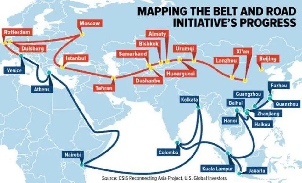
The Belt and Road Initiative is a global development strategy adopted by the Chinese government involving infrastructure development and investments in 152 countries and international organizations in Asia, Europe, Africa, the Middle East, and the Americas.

  • Belt” refers to the overland routes for road and rail transportation, called “the Silk Road Economic Belt; whereas “road” refers to the sea routes, or the 21st Century Maritime Silk Road.The BRI announced in 2013, is made up of a “belt” of overland routes and a maritime “road”, which aims to connect Asia, Europe and Africa.
  • It was known as the One Belt One Road (OBOR) and the Silk Road Economic Belt and the 21st-century Maritime Silk Road until 2016 when the Chinese government considered the emphasis on the word “one” was prone to misinterpretation.
  • The 21st Century Maritime Silk Road designed to provide an impetus to trade from China to Europe through the South China Sea and the Indian Ocean, and from China through the South China Sea towards the South Pacific.

The Chinese government calls the initiative “a bid to enhance regional connectivity and embrace a brighter future”. Some observers see it as a push for Chinese dominance in global affairs with a China-centered trading network. The project has a targeted completion date of 2049, which coincides with the 100th anniversary of the People’s Republic of China.

one belt one road countries list and Participant | UPSC IAS
Belt and Road Initiative Participant Map

Significance of Belt and Road Initiative (BRI) Project | UPSC – IAS

  • In the wake of the global slowdown, BRI offers a new model of development to China to maintain its economic growth. OBOR envisions building networks of roadways, railways, maritime ports, power grids, oil and gas pipelines, associated infrastructure projects which helps Chinese economy.
  • BRI has domestic and international dimension: as it visualises a shift from developed markets in the west to developing economies in Asia, Africa And a shift in China’s development strategy concentrating on provinces in central and western China instead of the developed east coast region.
  • Strategically important as China utilizes its economic clout to build it soft power.

Criticism and Issues with Belt and Road Initiative (BRI) Project | UPSC – IAS

  • Debt-trap diplomacy of China where BRI projects are pushing recipient countries into indebtedness and do not transfer skills or technology. For instance, Hambantota port, where Sri Lanka was forced to lease the port to China for 99 years. Also, there has been rethinking of projects in Malaysia, Maldives, Ethiopia and even in Pakistan.
  • BRI represents political and economic ambitions of China making countries like the US, Japan, Germany, Russia, and Australia unhappy about the impact of Beijing’s moves on their own economic and political interests.
  • China-Pakistan Economic Corridor (CPEC), an important component of BRI, passes through Pakistan-Occupied Kashmir, is the main reason for India signaling its displeasure over BRI and not participating in both the BRFs.

Other concerns raised include:

  • operational problems
  • lack of information transparency
  • lack of evaluation on the impact of regional social culture
  • Over-expansion of the scope of the types of BRI projects,
  • Environmental concerns stemming from China’s infrastructure buildout

Why India should join Belt and Road Initiative (BRI) Project ? | UPSC – IAS

  • India as a participant of Asian era: Projected as Project of the century, BRI signals the political end of the old order where the G7 shaped the economic agenda. BRI involves 126 countries and 29 international organizations covering half of world’s population, and India may be isolated from this new economic order.
  • Shaping global economic rules: BRI is evolving standards of multilateralism, including linkages with the United Nations SDGs. The IMF described it as a “very important contribution” to the global economy and is collaborating with the Chinese authorities on sharing the best international practices, regarding fiscal sustainability and capacity building. Being part of it, India can also shape new economic global rules.
  • A platform for voicing Indian concerns: Italy, a member of the G7, also joined BRI, and Japan also sent special envoy, despite its reservations over project. India could also have raised concerns by joining the BRF.
  • India should provide alternatives and solutions– rather than merely criticizing the project. India should improve its implementation performance so as to provide a viable option to other countries.

Why India is boycotting Belt and Road Initiative (BRI) Project ? | UPSC – IAS

  • CPEC violates India’s sovereignty as it passes through the part of the Pakistan-occupied Kashmir that belongs to India and no country can accept a project that ignores its core concerns on sovereignty and territorial integrity.
  • India also raised concerns regarding unsustainable debt trap, environmental concerns, and transparency in assessment of project costs, and skill and technology transfer to help long term running and maintenance of the assets created by local communities.
  • India is too big to be isolated and India’s continued objection will make China to consider its core concerns.

A Way forward | UPSC – IAS

  • India should highlight its territorial concerns to China and seek appropriate response recognising India’s sovereignty.
  • India should give a South Asian character to the two BRI corridors on India’s western and eastern flanks, by linking them with plans for connectivity in the ASEAN and SAARC region.
  • India can cooperate with like-minded countries like Japan, US, Australia to provide alternatives to BRI, e.g. Asia-Africa Growth Corridor etc.

Food processing and related Industries in India | UPSC – IAS

Food processing and related Industries in India UPSC - IAS GS3 Economic Development

Food processing and related Industries in India GS3 Vision IAS Economic Development

Food processing and related Industries in India | UPSC – IAS

Food processing is the transformation of agricultural products into food, or of one form of food into other forms. Food processing includes many forms of processing foods, from grinding grain to make raw flour to home cooking to complex industrial methods used to make convenience foods.

Food processing is a large sector that covers activities such as:-

  • Agriculture,
  • Horticulture,
  • Plantation,
  • Animal husbandry and
  • Fisheries.

Food  processing also includes other industries that use agriculture inputs for manufacturing of edible products. Based on International Standard Industrial Classification, it has been assumed that the factories listed in the following groups can be summed up to constitute Food Processing industries.

Scope and Significance of the Food Processing Sector in India | UPSC – IAS

India is one of the world’s largest producers as well as consumer of food products, with the sector playing an important role in contributing to the development of the economy. It is the fifth largest industry in our country in terms of production, consumption, export and growth.

With a population of more than one billion individuals and food constituting a major part of the consumer’s budget, this sector has a prominence next to no other businesses in the country.

  • Moreover the importance of this sector to India’s economy becomes all the more relevant, considering the fact that this sector continued to perform well, despite fall in GDP number and poor performance by many other industries, during recession in 2008-09.

The industry encompasses a gamut of activities involved in reaching the final product to the consumer, starting with farming activity to produce inputs, processing of the inputs to create products and the associated supply chain involved in delivering the products. It has increasingly come to be seen as a potential source for driving the rural economy as it brings about synergy between the consumer, industry and agriculture. A well developed food processing industry is expected to increase:-

  • Farm gate prices,
  • Reduce wastages,
  • Ensure value addition,
  • Promote crop diversification,
  • Generate employment opportunities as well as export earnings.

This sector is also capable of addressing critical issues of food security and providing wholesome, nutritious food to our people.

  • While the industry is large in terms of size, it is still at a nascent stage in terms of development. Out of the country’s total agriculture and food produce, only 2 per cent is processed.  However, the contribution of food processing sector to GDP has been growing faster than that of the agriculture sector.
  • If the contribution to GDP of both agricultural sector and food processing sector were growing at the same rate, then it would mean that the growth in food processing sector is only due to increased agricultural raw material supply. However, more and more agricultural products are being converted (in value terms) to food products. This means that the level of processing in value terms has been increasing.
  • Primary food processing (packaged fruit and vegetables, milk, milled flour and rice, tea, spices, etc.) constitutes around 60 percent of processed foods. It has a highly fragmented structure that includes thousands of rice-mills and hullers, flour mills, pulse mills and oilseed mills, several thousands of bakeries, traditional food units and fruits, vegetable and spice processing units in unorganized sector.
  • In comparison, the organized sector that includes flour mills, fish processing units, fruit and vegetable processing units, meat processing units and numerous dairy processing units at state and district levels is relatively much smaller.

India’s strengths in the Food Processing Sector | UPSC – IAS

Favourable-Factor Conditions

  • India has access to several natural resources that provides it a competitive advantage in the food processing sector. Due to its diverse agro-climatic conditions, it has a wide-ranging and large raw material base suitable for food processing industries. Presently a very small percentage of these are processed into value added products. The semi processed and ready to eat packaged food segment is still evolving.
  • India’s comparatively cheaper workforce can be effectively utilized to set up large low cost production bases for domestic and export markets.
  • Cost of production in India is lower by about 40 per cent over a comparable location in EU and 10-15 per cent over a location in UK. Along with these factor conditions, India has access to significant investments to facilitate food processing industry. There have been increasing investments not only by domestic firms and Indian government, but also foreign direct investment.

Related and Supporting Industries

  • The Indian food processing industry has significant support from the well-developed R&D and technical capabilities of Indian firms. India has a large number of research institutions like Central Food Technological Research Institute, Central Institute of Fisheries Technology, National Dairy Research Institute, National Research and Development Centre etc. to support the technology and development in the food processing sector in India.

Government Regulations and Support

  • The Government of India has taken several initiatives to develop the food processing industry in India. The government has been developing agri-zones and mega food parks to promote food processing industry in India. In order to promote investment in the food processing sector, several policy initiatives have been taken during recent years

In Short the Strengths of Food processing Industries in India are:-

  • Round the year availability of raw materials.
  • Social acceptability of food-processing as an important area and support from the central government.
  • Vast network of manufacturing facilities all over the country.
  • Vast domestic market.

Success Factors of Food Processing Industries in India | UPSC – IAS

The Indian food processing industry growth potential cannot be disputed; however, it requires certain competencies and success factors to fructify this potential. These include addressing the current gaps in the value chain as well as leveraging on the various advantages the country provides. Investors in the sector need to be aware of these factors and build the required capabilities in their business to ensure success. Some of the key success factors are discussed below.

Integrated Supply Chain and Scale of Operations

  • While India ranks second in production of fruits & vegetables, nearly 20 to 25 percent of this production is lost in spoilage in various stages of harvesting. The key issues are poor quality of seeds, planting material and lack of technology in improving yield.
  • Ensuring good quality produce entails investments in technology and ability to sustain a long gestation period for the harvest.
  • Good quality production also results in better quality of processed fruits. Hence there is a need to establish backward linkages with the farmers with the help of arrangements such as contract farming to improve the quality of the produce.
  • Small or large Scale is a key factor in the processing industry. Nearly 90 per cent of the food processing units are small in scale and hence are unable to exploit the advantages of economies of scale. This is also true with land holdings.

Processing Technology

  • Most of the processing in India is currently manual. There is limited use of technology like pre-cooling facilities for vegetables, controlled atmospheric storage and irradiation facilities. This technology is important for extended storage of fruits and vegetables in making them conducive for further processing.
  • In the case of meat processing, despite the presence of over 3600 licensed slaughterhouses in India, the level of technology used in most of them is limited, resulting in low exploitation of animal population.
  • Bringing in modern technology is an area that existing as well as new investors in the sector can focus on, this will make a clear difference in both process efficiencies as well as quality of the end product.

Increasing Penetration in Domestic Markets

Most of the processing units are export oriented and hence their penetration levels in the domestic market are low. For example:-

  • Penetration of processed fruits and vegetables overall is at 10 percent
  • The relative share of branded milk products ,especially ghee is still low at 2 per cent
  • Penetration of culinary products is still 13.3 per cent and is largely tilted towards metros
  • Consumption of packaged biscuits for indian consumers is still low at 0.48 percent while that for Americans is 4 percent

However, there is increasing acceptance of these products amongst the urban population. India has a large untapped customer base and even a small footprint in the domestic market would enable the player to gain significant volumes. Acceptance in the domestic market and hence higher penetration is driven by the following factors:-

Competitive Pricing

  • Consumers of processed foods are extremely price sensitive even a small change in pricing can have significant impact on consumption. For instance, the launch of PET bottles, new price points and package sizes in non carbonated drinks (such as by Coca Cola) increased in-home consumption from 30 per cent in 2002 to 80 per cent in 2003. Competitive pricing: also enables penetration in the rural markets.

Brand Competitiveness

  • Share of branded products in purchases of Indian consumers has also increased substantially. This is especially true for urban consumers. Branded products like Basmati rice and KFC’s chicken have been very successful implying that there is a good demand for hygienic branded products at reasonable prices.

Product Innovation

  • Certain processed food categories such as snack foods are impulse purchase products where consumers look for novelty and new flavours and hence these categories lack brand loyalties. Visibility through attractive packaging boosts consumption.
  • Increasing time constraints amongst the working middle class has boosted consumption of products like instant soups, noodles and ready-to-make products.
  • Innovation in packaging and product usage is an important success factor for processed foods..

Challenges for the Food Processing Sector in India | UPSC – IAS

(Problems and prospects of Food Processing Industry in India | UPSC – IAS)

The challenges for the food processing sector are diverse and demanding, and need to be addressed on several fronts to derive maximum market benefits. A combination of uncontrollable and controllable factors has affected the growth of the sector and has acted as a hindrance in achieving its potential.

  • The uncontrollable factors include fragmentation of land holdings which has resulted in lack of scale and has made investments in automation unviable; regional climatic variations which impact the production; and the constraints in land availability due to competing pressure from urbanization, constructions and industrialization. These factors are difficult to address and hence have to be discounted for while accounting for the inadequate growth of the sector. It is the controllable factors which can be addressed by companies and the Government, which impact the production levels and hence need proper actions.
  • Even today India is grappling with issues of quality and quantity of raw produce, low labor productivity with slow adoption of technology. On the Infrastructure front, we have supply chain and wastage related problems and low levels of value addition etc.
  • The other issues of concern, holding this sector back are impaired access to credit; inconsistency in state and central policies, which requires both the Center and the State to work as one single cohesive unit.

There are a large number of players in the organized as well as unorganized sector. The organized sector is small but growing – for example, it forms less than 15 percent of the dairy sector and around 48 per cent of the fruits and vegetable processing. The sector offers potential for growth and a large number of Multinational Corporations have entered into India to leverage this opportunity.

Despite the above-mentioned strengths, the following areas have been identified by the Ministry of Food Processing Industries where investments are required:

  • Mega food parks
  • Agro-infrastructure and supply chain integration
  • Logistics and cold chain infrastructure
  • Fruit and vegetable products
  • Animal products, meat and dairy
  • Fisheries and seafood
  • Cereals, consumer foods and ready-to-eat foods
  • Wine and beer
  • Machinery and packaging

What are the Weaknesses of Food processing and related Industries in India ?

  • High requirement of working capital.
  • Low availability of new, reliable and better accuracy instruments and equipments
  • Inadequate automation w.r.t. information management.
  • Remuneration is less attractive for talent in comparison to contemporary disciplines.
  • Inadequately developed linkages between R&D I.abs and industry.

What are the Opportunities Food processing and related Industries in India ?

  • Large crop and material base in the country due to agro-ecological variability offers vast potential for food processing activities.
  • Integration of developments in contemporary technologies such as electronics, material science, computer, bio-technology etc. offer vast scope for rapid improvement and progress.
  • Opening of global markets may lead to export of our developed technologies and facilitate generation of additional income and employment opportunities.

What are the Threats Food processing and related Industries in India ?

  • Competition from global players
  • Loss of trained manpower to other industries and other professions due to better working conditions prevailing there may lead to further shortage of manpower.
  • Rapid developments in contemporary and requirements of the industry may lead to fast obsolescence.

Square Kilometre Array Radio Telescope Project | UPSC – IAS

Square Kilometre Array India UPSC - IAS

Square Kilometre Array India UPSC - IAS

Square Kilometre Array Radio Telescope Project | UPSC – IAS

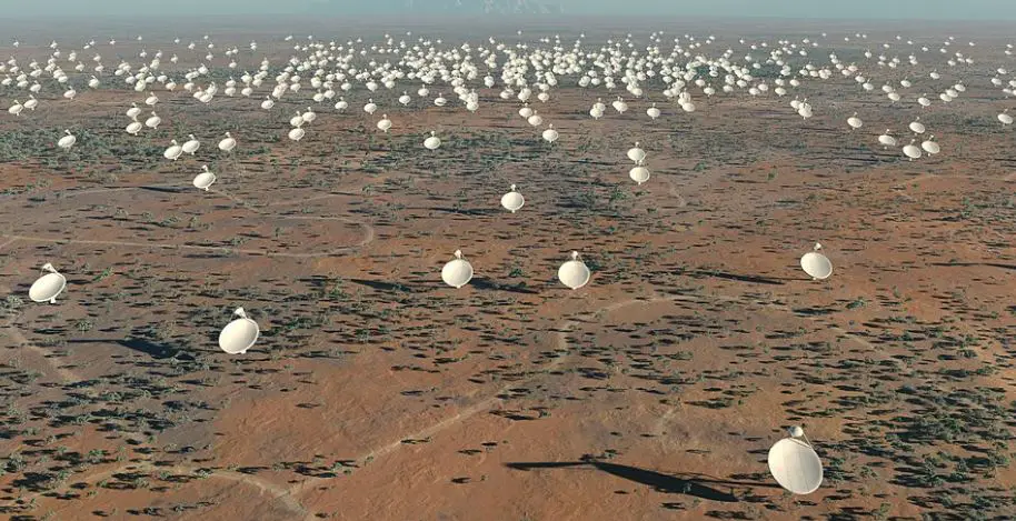
The Square Kilometre Array (SKA) is a radio telescope project proposed to be built in Australia and South Africa. If built, it would have a total collecting area of approximately one square kilometre. It would operate over a wide range of frequencies and its size would make it 50 times more sensitive than any other radio instrument. It would require very high performance central computing engines and long-haul links with a capacity greater than the global Internet traffic as of 2013. It should be able to survey the sky more than ten thousand times faster than before.

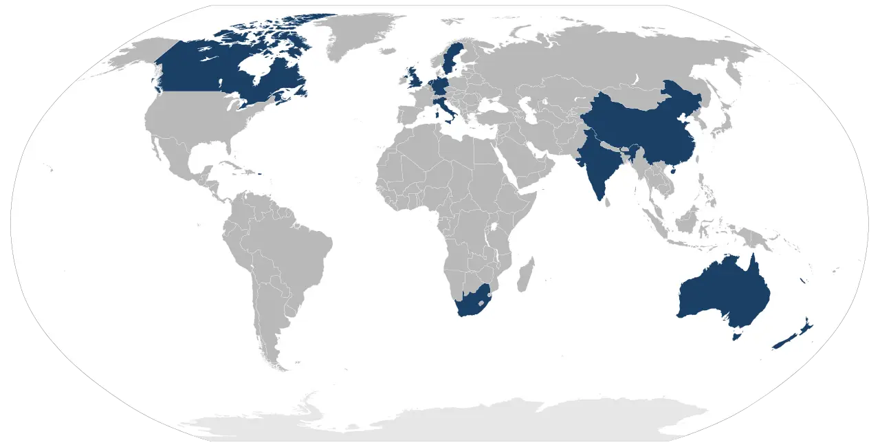
On 12 March 2019, the Square Kilometre Array Observatory (SKAO) was founded in Rome by seven initial member countries, with several other expected to join in the future. This international organisation is tasked with building and operating the facility, with the first construction contracts scheduled to be awarded in late 2020

Location: – South Africa’s Karoo region and Western Australia’s Murchison Shire were chosen as co-hosting locations for this project.; Built Year: – 2024 – 2030.

Square Kilometre Array India UPSC - IAS Countries that participated in the preparatory phase of SKA
Countries that participated in the preparatory phase of Square Kilometre Array

The Square Kilometre Array (SKA) is a global project with eleven member countries that aims to answer fundamental questions about the origin and evolution of the Universe. In the early days of planning, China vied to host the Square Kilometre Array (SKA), proposing to build several large dishes in the natural limestone depressions (karst) that dimple its southwestern provinces; China called their proposal Kilometer-square Area Radio Synthesis Telescope (KARST). In April 2011, Jodrell Bank Observatory of the University of Manchester, in Cheshire, England was announced as the location for the project headquarters.

More About Square Kilometre Array (SKA) Project | UPSC – IAS

  • Square Kilometre Array (SKA) project is an international effort to build the world’s largest radio telescope, with eventually over a square kilometre (one million square metres) of collecting area.
  • It will use 1000s of dishes and up to a million low-frequency antennas that will enable astronomers to monitor the sky in unprecedented detail and survey the entire sky much faster than any system currently in existence.
  • Karoo will host the core of the high and mid frequency dishes and Murchison will host the low-frequency antennas.
  • Recent Developments – MeerLITCH is the world’s first optical telescope linked to a radio telescope launched in South Africa.
  • The device forms part of the Square Kilometre Array (SKA) project and will be linked to MeerKAT, a radio telescope located 200km away.
  • Scientists at Cambridge have finished designing the data processor of SKA’s telescopes.

Sea Level Rise and its Causes and Effects | UPSC – IAS

Ross Ice shelf in Antarctica Melting UPSC - IAS gk today the hindu pib

Ross Ice shelf in Antarctica & Sea Level Rise | UPSC - IAS | gk today the hindu pib

Sea Level Rise and its Causes and Effects | UPSC – IAS

Coastal areas Globally tens of millions of people will be displaced in the latter decades of the century if greenhouse gases are not reduced drastically. Many coastal areas have large population growth, which results in more people at risk from sea level rise.

Main cause of sea level rise are as follows:-

  • Melting of Ice Sheets and Glaciers,
  • Thermal expansion,
  • A slowing Gulf Stream, and
  • Sinking land all contribute to Sea level rise.

Effects of Sea level Rise | UPSC – IAS

Current and future sea level rise is set to have a number of impacts, particularly on coastal systems. Such impacts include:-

  • Increased coastal erosion,
  • Higher storm-surge flooding,
  • Inhibition of primary production processes,
  • More extensive coastal inundation,
  • Changes in surface water quality and groundwater characteristics,
  • Increased loss of property and coastal habitats,
  • Increased flood risk and potential loss of life,
  • Loss of non-monetary cultural resources and values,
  • Impacts on agriculture and aquaculture through decline in soil and water quality,
  • And loss of tourism, recreation, and transportation functions.

Many of these impacts are detrimental. Owing to the great diversity of coastal environments; regional and local differences in projected relative sea level and climate changes; and differences in the resilience and adaptive capacity of ecosystems, sectors, and countries, the impacts will be highly variable in time and space. River deltas in Africa and Asia and small island states are particularly vulnerable to sea-level rise.

  • The rising seas pose both a direct risk: unprotected homes can be flooded, and indirect threats of higher storm surges, tsunamis and king tides. Asia has the largest population at risk from sea level with countries such as Bangladesh, China, India, Indonesia, and Vietnam having very densely populated coastal areas.
  • The effects of displacement are very dependent on how successful governments will be in implementing defenses against the rising sea, with concerns for the poorest countries such as sub-Saharan countries and island nations.
  • Sea levels are rising at the fastest rate in 3,000 years. From 2018 to 2019, the global sea level rose to 6.1 millimeters.

About Ross ice shelf | UPSC – IAS

The Ross Ice Shelf is the largest ice shelf of Antarctica (as of 2013 an area of roughly 500,809 square kilometres (193,363 sq mi) and about 800 kilometres (500 mi) across). It is several hundred metres thick. The nearly vertical ice front to the open sea is more than 600 kilometres (370 mi) long, and between 15 and 50 metres (50 and 160 ft) high above the water surface. Ninety percent of the floating ice, however, is below the water surface.

Ross Ice shelf in Antarctica Map and Diagram | UPSC - IAS

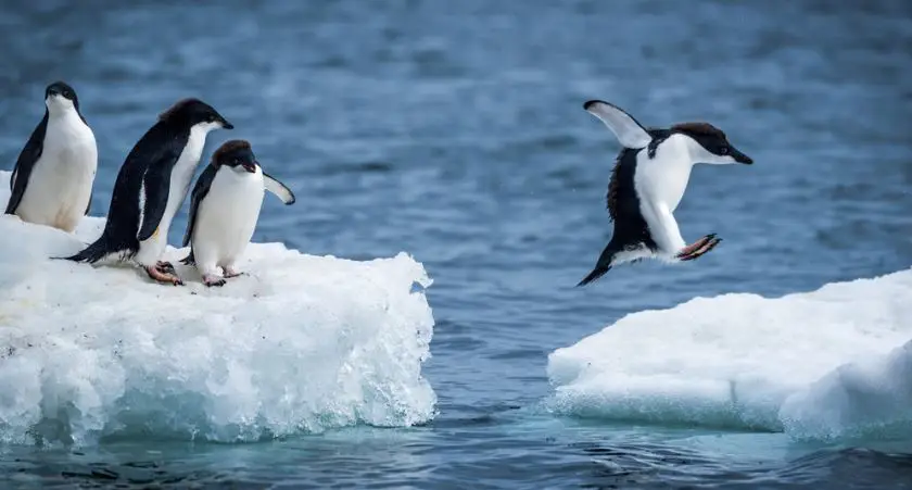
  • Antarctica’s Ross Ice Shelf is the world’s largest ice shelf roughly the size of France, is melting rapidly.
  • Recently it is found that the ice cap is melting rapidly leading to global sea-level rise of around 13.8 millimetres over the last 40 years.
  • The ice shelf is melting 10 times faster than the overall average, due to solar heating of the surrounding ocean surface.
  • Antarctica comprises 90 percent of the world’s ice, thus whatever happens to its ice and snow is a matter of serious concern, and if this situation continues, sea-levels would rise up to 60 meters by 2050 and the ocean would engulf coastal cities across the globe.

Compensatory Afforestation Fund Act | UPSC – IAS

Compensatory Afforestation Fund Rules vision ias UPSC - IAS

Compensatory Afforestation Fund Rules vision ias UPSC - IAS

Compensatory Afforestation Fund Act | UPSC – IAS

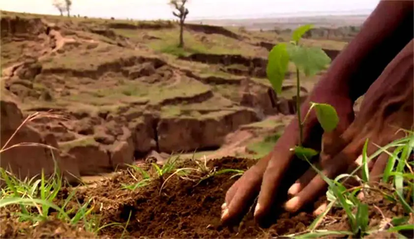
Compensatory Afforestation (CA) refers to afforestation and regeneration activities carried out as a way of compensating for forest land diverted to non-forest purposes. Here “non-forest purpose” means the breaking up or clearing of any forest land or a portion thereof for-

  • The cultivation of tea, coffee, spices, rubber, palms, oil-bearing plants, horticultural crops or medicinal plants;
  • any purpose other than reafforestation;

But does not include any work relating or ancillary to – Conservation, Development and management of forests and wildlife, namely,

  • The establishment of check-posts,
  • Fire lines,
  • Wireless communications and construction of fencing,
  • Bridges and culverts,
  • Dams,
  • Waterholes,
  • Trench marks,
  • Boundary marks,
  • Pipelines or other like purposes.

Compensatory Afforestation (CA) is one of the most important conditions stipulated by the Central Government while approving proposals for de-reservation or diversion of forest land for non-forest use. The compensatory afforestation is an additional plantation activity and not a diversion of part of the annual plantation programme.

Elements of Schemes for Compensatory Afforestation | UPSC – IAS

The scheme for compensatory afforestation should contain the following details:-

  • Details of equivalent non-forest or degraded forest land identified for raising compensatory afforestation.
  • Delineation of proposed area on a suitable map.
  • Agency responsible for afforestation.
  • Details of work schedule proposed for compensatory afforestation.
  • Cost structure of plantation, provision of funds and the mechanism to ensure that the funds will be utilised for raising afforestation.
  • Details of proposed monitoring mechanism.

More about Compensatory afforestation Fund Act| UPSC – IAS

The government enacted Compensatory Afforestation Fund Act 2016 to provide a proper institutional mechanism for compensatory afforestation matters.

The salient features of the Act include:-

  • The Act established National Compensatory Afforestation Fund (NCAF) under the Public account of India and State Compensatory Afforestation Funds under public accounts of states.
  • The National Fund will receive 10% of these funds, and the State Funds will receive the remaining 90%.
  • The fund will be used for compensatory afforestation, additional compensatory afforestation, penal compensatory afforestation, net present value, catchment area treatment plan or any money for compliance of conditions stipulated by the Central Government while according approval under the provisions of the Forest (Conservation) Act, 1980.
  • Act provides statutory status for two ad-hoc institutions, namely
    • National Compensatory Afforestation Fund Management and Planning Authority (NCAFM-PA) for management and utilisation of NCAF.
    • State Compensatory Afforestation Fund Management and Planning Authority for utilisation of State Compensatory Afforestation Fund.
  • The act also seeks to provide for constitution of a multidisciplinary monitoring group to monitor activities undertaken from these funds.
  • The act also provides for annual audit of the accounts by the Comptroller and Auditor General.

Compensatory Afforestation Fund 2019 the Hindu UPSC - IAS

Issues with the Act | UPSC – IAS

  • Compromising community forest rights: The land identified for compensatory afforestation would be under forest department’s jurisdiction thus, having adverse consequences for the hard-won rights of tribals and forest dwellers.
  • Lack of monitoring mechanism for expenditure from funds despite findings of Comptroller and Auditor General in 2013 about massive misutilization of funds by the forest department.
  • Scarcity of land as land is a limited resource, and is required for multiple purposes, such as agriculture, industry, etc. The problem is compounded by unclear land titles.
  • Inadequate Capacity of state forest departments for planning and implementation. Still utilisation of 90% of funds depend on it.
  • Low quality forest cover: Compensatory afforestation cannot make up for the ecological value lost by cutting the existing forests. Also, computing the appropriate Net Present Value of a forest is a challenge.
  • Poor survival rate of plantations raised under compensatory afforestation also raises serious questions about their effectiveness.
  • Diversion as land banks: The creation of land banks for Compensatory afforestation from revenue forests and degraded forests (on which communities have got traditional rights) further allows for takeover of community land.

A Way forward | UPSC – IAS

  • Primacy of Gram sabha: The CAF Act needs to be integrated with the FRA and PESA by centring the role of gram sabhas and incorporating land and forest rights guarantees.
  • Management of Compensatory afforestation: Emphasis should not only be on plantation but also on the maintenance of Compensatory afforestation.

Atmospheric Waves Experiment (AWE) mission | NASA | UPSC – IAS

Atmospheric Waves Experiment (AWE) NASA UPSC - IAS The Hindu

Atmospheric Waves Experiment (AWE) NASA UPSC - IAS The Hindu

Atmospheric Waves Experiment (AWE) mission| NASA | UPSC – IAS

The NASA has selected a new mission Atmospheric Waves Experiment (AWE) and is expected to be launched in August 2022, attached to the exterior of the Earth-orbiting International Space Station.

Atmospheric waves are motions of air in the Earth’s atmosphere which have different spatial (meters to thousands of kilometers) and temporal scales (minutes to weeks). They can impact the wind, density, pressure or temperature fields and can be identified as fluctuations of these parameters.

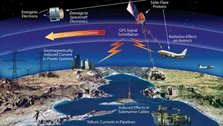
Atmospheric Waves Experiment (AWE) mission will help scientists understand and, ultimately, forecast the vast space weather system around our planet. Space weather is important  because it can have profound impacts – affecting-

    • Technology and astronauts in space,
    • Disrupting radio communications and,
    • At its most severe, overwhelming power grids.

About Atmospheric Waves Experiment (AWE)

  • It will investigate how waves in the lower atmosphere, caused by variations in the densities of different packets of air, impact the upper atmosphere.
  • Atmospheric Waves Experiment (AWE) will focus will focus on colourful bands of light in Earth’s atmosphere, called airglow, to determine what combination of forces drive space weather in the upper atmosphere.
  • Earlier it was thought that only Sun’s constant outflow of ultraviolet (UV) light and particles, solar wind, could affect airglow region. However, now researchers have learned that Earth’s weather also have effect on it.
  • AWE was one of two finalists selected by NASA in 2017 as a heliophysics mission of opportunity for NASA’s Explorers program of small missions. The other finalist was the Sun Radio Interferometer Space Experiment (SunRISE), a constellation of cubesats that would act as a synthetic aperture radio telescope to study the formation of solar storms.

What is Heliophysics ?

  • It is the study of the effects of the Sun on the Solar System; it addresses problems that span a number of existing disciplines – solar and heliospheric physics, and magnetospheric and ionospheric physics for the Earth and other planets.
  • The discipline is closely related to the study of Space Weather, which can affect the technology on which we all depend, however heliophysics is more generalised covering all parts of the Solar System rather than just the Sun-Earth connection.

India Cooling Action Plan UPSC | 20 Year | Ozone Layer | UPSC – IAS

India Cooling Action Plan (ICAP) 20 Year Road Map UPSC - IAS

India Cooling Action Plan (ICAP) 20 Year Road Map UPSC - IAS

India Cooling Action Plan (ICAP) | 20 Year Road Map |Ozone Layer| UPSC

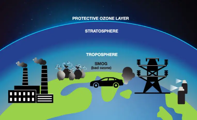
Montreal Protocol is a global agreement to protect the ozone layer, by weaning out the production and consumption of ozone-depleting substances, and is similar to the Paris Agreement. The Montreal Protocol is quite the success story, and is the only environmental treaty to have been ratified by 197 UN member countries. It has been successful in reducing global production, consumption and emission of ozone layer-depleting substances

  • Ministry for Environment, Forest and Climate Change released the India Cooling Action Plan – a 20 year road map (From 2018 to 2038).

About Cooling Action Plan | UPSC – IAS

  • India is the first country in the world to develop such a document (ICAP), which addresses cooling requirement across sectors and lists out actions which can help reduce the cooling demand. This will help in reducing both direct and indirect emissions.
  • The Montreal Protocol on Substances that Deplete the Ozone Layer (a protocol to the Vienna Convention for the Protection of the Ozone Layer) is an international treaty designed to protect the ozone layer by phasing out the production of numerous substances that are responsible for ozone depletion. As per the Montreal Protocol, India is taking steps to curb elements that deplete the ozone layer.
  • India is one of the first countries in the world to develop a comprehensive Cooling Action Plan – to fight ozone layer depletion adhering to the Montreal Protocol.

Main targets of India Cooling Action Plan (ICAP)

  • Reduce cooling demand across sectors by 20% to 25% by 2037-38.
  • Reduce refrigerant demand by 25% to 30% by 2037-38,
  • Reduce cooling energy requirements by 25% to 40% by 2037-38,
  • Recognize “cooling and related areas” as a thrust area of research under national S&T Programme,
  • Training and certification of 100,000 servicing sector technicians by 2022-23, synergizing with Skill India Mission

ICAP provides an integrated vision:

  • To address the cooling requirement across different sectors of the economy such as residential and commercial buildings, cold-chain, refrigeration, transport and industries.
  • To lists out actions which can help reduce the cooling demand, enhancing energy efficiency and better technology options.

Significance of India Cooling Action Plan (ICAP) | UPSC – IAS

  • Thermal comfort for all – Provision for cooling for Economically Weaker Sections and Low Income Group housing.
  • Sustainable cooling – Reducing both direct and indirect Greenhouse Gases emissions related to cooling.
  • Doubling Farmers Income – Through better cold chain infrastructure–less wastage of produce leading to better value of produce to farmers.
  • Skilled workforce by creating jobs in service sector. For example- Skilling of AC and refrigerator service technicians.
  • Robust R&D on alternative cooling technologies to provide push to innovation in cooling sector.

Key actions included under India Cooling Action Plan (ICAP) | UPSC – IAS

  • Cooling buildings naturally through better design: Passively cooled building designs with natural and mechanical ventilation.
  • Adopting comfortable range of thermostat set-points in commercial buildings as well as for affordable housing projects under the Pradhan Mantri Awas Yojana for economically weaker sections.
  • Improving efficiency of cooling appliances: The plan makes ACs a focus area as the majority of energy consumption in space cooling is by room air-conditioners. A drive for widespread adoption of 5-star labelled fans and room air conditioners in new and existing public buildings.
  • Reducing cost of efficient air-conditioning through public procurement schemes.
  • Skilling and certifying AC and refrigerator service technicians.
  • Promoting renewable energy-based energy efficient cold chains
  • Investing in research and development (R&D) of refrigerant gases that do not harm or warm the planet.

Why India needs ICAP ? | UPSC – IAS

  • Cooling is an important developmental necessity as it is needed in different sectors of the economy. For example: Space cooling for buildings consumes 60% of the total energy supply for cooling in India.
  • India’s per capita space cooling consumption is nearly 1/4th of global average consumption. (Global average-272 kWh whereas India’s 69 kWh).
  • However, according to recent report, the current technology used in conventional cooling systems in air conditioners and refrigerators, coupled with an increasing demand for such appliances and rising global temperatures, could spur a 64 % increase in household energy use and produce over 23 million tonnes of carbon emissions by 2040.
  • This presents an urgent need (for India and other tropical countries) to develop a sustainable plan addressing both concerns.

Unlocking National Energy Efficiency Potential (unnatee) launched | UPSC – IAS

Unlocking National Energy Efficiency Potential (unnatee) launched UPSC - IAS UPPCS PCS

Unlocking National Energy Efficiency Potential (unnatee) launched UPSC - IAS UPPCS PCS

Unlocking National Energy Efficiency Potential (unnatee) | UPSC – IAS

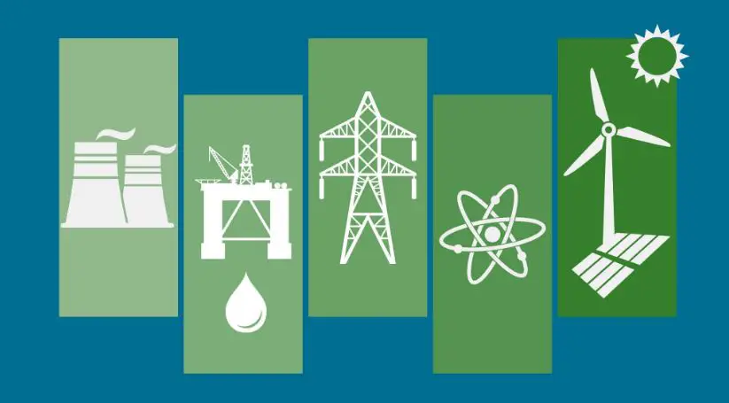
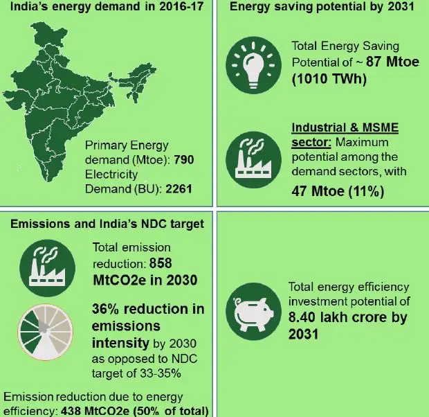
Bureau of Energy Efficiency (BEE) has developed a national strategy document titled UNNATEE (Unlocking NATional Energy Efficiency Potential) towards developing an energy efficient nation (2017-2031).

  • It describes a plain framework and implementation strategy to establish a clear linkage between energy supply-demand scenarios and energy efficiency opportunities. The document offers a comprehensive roadmap to address India’s environmental and climate change mitigation action through energy efficiency measures.
  • This exercise is first of its kind, clearly delineating the energy efficiency targets for the respective demand sectors upto the state levels. Developing India’s blueprint of effective energy efficiency strategy is a leap towards stimulating energy efficiency ecosystem and enabling reduction of the pressure on demand

Why India need UNNATEE ? | UPSC – IAS

  • In India, there is still an immense potential to be realized from large scale implementation of energy efficiency interventions in the various demand sectors like industry, agriculture, transport, municipal, domestic and commercial lighting and appliances and Micro, small and medium scale enterprises (MSME).
  • In this context, BEE, with support from PricewaterhouseCoopers Private Limited has developed the national strategic plan for energy efficiency, presented in the form of this report “Unlocking National Energy Efficiency Potential – UNNATEE, Strategy plan towards developing an energy efficient nation (2017-2031)”.

Unlocking National Energy Efficiency Potential (unnatee) launched UPSC - IAS

Background Knowledge

  • India is expected to grow at around 8% and almost every economic activity requires energy. If energy consumption (primary energy and electricity) in India were to continue along current lines, it could lead to a growing imbalance between supply and demand.
  • The gap between supply and demand can be fulfilled by either increasing generation or by enhancing the efficiency of energy usage.

Some key numbers can be seen as-

  • India’s energy demand in 2016-17= 790 Mtoe(million tonnes of oil equivalent)
  • Energy saving potential by 2031= 87 Mtoe
  • Total emission reduction= 858 MtCO2 in 2030
  • Total energy efficiency investment potential= Rs. 8.40 lakh crore by 2031

UNNATEE Implementation Strategy | UPSC – IAS

Favourable Regulations | UPSC – IAS

Through an overarching energy efficiency policy, which includes targets, incentives and penalties.

  • Agriculture- Inclusion of agro projects under the National Clean Energy Fund
  • Buildings- Introduction of incentives for purchasing energy efficient houses.
  • Industry- Increasing the scope of the PAT programme.
  • Transport- Roll out of the proposed FAME-II scheme.

Institutional Framework | UPSC – IAS

through strong enforcement mechanism at state levels, which would lend further strength to the national and local level program.

  • Agriculture– A single window system for export of products and services will improve the competitiveness of sector R&D.
  • Buildings- A reporting framework for where the states are required to update their progress in implementation of Energy Conservation Building Code in their state.
  • Industry- Creation of an energy management cell.

Availability of Finance | UPSC – IAS

In the form of a revolving fund, risk guarantee, On-bill financing, Energy Savings Insurance, Energy Conservation Bonds.

  • Agriculture- Reduce interests in priority sector lending.
  • Buildings- Targeting low LCOC rather than low initial building cost by building for affordable maintenance.
  • Industry- Creation of fund for R&D in industry with 1% of turnover.
  • Transport- Introduction of ToD tariff rates for EVs. E.g. Telangana State Electricity Regulatory Commission has fixed the tariff for charging stations at Rs. 6 per unit.

Use of technology | UPSC – IAS

  • Including Internet of Things and Blockchain have the ability to bring an energy revolution across sectors. Example in agriculture (smart control panels), municipal (CCMS), commercial (building management systems), domestic (electric cook stoves).

Stakeholder Engagement | UPSC – IAS

  • Would result in faster adoption and smoother implementation. E.g. for adoption of electric vehicles it is important to first have policies for promotion and adoption of EVs, institutional framework to train new breed of engineers to make the transition to EVs, ecosystem players to provide services like EV charging and consumers to buy the vehicles.
  • Data Collection- Setting up of a Nodal Agency that advocates data collection and dissemination, covering the entire energy value chain of the country.
  • Setting State wise targets- Mandatory reporting of sector wise energy consumption, status of all EE programmes and the target of the same and energy efficiency roadmap.
  • Center of Excellence for industries- to increase R&D in specific sectors.

Swap Facility in banking | RBI | UPSC – IAS

Swap Facility in banking RBI UPSC - IAS Gk today investopedia

Swap Facility in banking RBI UPSC - IAS Gk today investopedia

Swap Facility in banking | RBI | UPSC – IAS

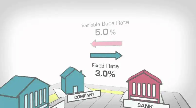
A swap is a derivative contract through which two parties exchange the cash flows or liabilities from two different financial instruments. Most swaps involve cash flows based on a notional principal amount such as a loan or bond, although the instrument can be almost anything. Usually, the principal does not change hands. Each cash flow comprises one leg of the swap. One cash flow is generally fixed, while the other is variable and based on a benchmark interest rate, floating currency exchange rate or index price

  • Swaps were first introduced to the public in 1981 when IBM and the World Bank entered into a swap agreement. Today, swaps are among the most heavily traded financial contracts in the world: the total amount of interest rates and currency swaps outstanding was more than $348 trillion in 2010, according to Bank for International Settlements (BIS)
  • Swap Bank A swap bank is a generic term to describe a financial institution that facilitates swaps between counterparties.
  • The two primary reasons for a counterparty to use a currency swap – are to obtain debt financing in the swapped currency at an interest cost reduction brought about through comparative advantages each counterparty has in its national capital market, and/or the benefit of hedging long-run exchange rate exposure. These reasons seem straightforward and difficult to argue with, especially to the extent that name recognition is truly important in raising funds in the international bond market.

Recently, Reserve Bank of India (RBI) has introduced a $5-billion dollar-rupee swap facility for the banks to facilitate permanent liquidity support.

Issue Background Knowledge

  • The Reserve Bank of India has various monetary tools to manage liquidity in the financial market.
  • Adjusting repo rates and purchasing bonds by conducting open market operations (OMO) are a couple of tools which the RBI uses regularly either to increase or decrease the currency supply in the market.
  • However, despite these efforts, there is a liquidity crunch in the market and as a result, this swap facility has been announced to increase the supply of rupees in the market.

Need for this Swap Facility | UPSC – IAS

  • Limitation of Open Market Operations- Banks may not have adequate collateral to pledge to borrow from the RBI because of high SLR (statutory liquidity ratio) and LCR (liquidity coverage ratio) requirement.
  • Thus, this liquidity support through dollar purchase would be needed to partially meet the durable liquidity needs of the system

Widened Liquidity Deficit

  • Indian financial markets have been undergoing liquidity problems since the IL&FS crisis emerged last year. The system liquidity is dry to the tune of little more than Rs 1 trillion.
  • This crunch will become more acute in the coming days due to advanced tax outflows (estimated at Rs 1.5 trillion) and the goods and services tax (estimated at Rs 1 trillion), which will suck out liquidity from the system.
  • This liquidity will return only in the next financial year as the government starts spending. Till then, rates may shoot up if adequate liquidity support is not given to banks.
  • In addition to this, the demand for rupees is expected to spike in the coming weeks as a result of a huge spending towards the upcoming general elections.

Significance of Swap Facility | UPSC – IAS

  • Overwhelming response received – Banks offered $16.31 billion for the proposed swaps of up to $5 billion. The RBI accepted $5.02 billion at a cut-off premium of Rs 7.76 for three-year dollars. This has established the instrument as a credible liquidity tool and paving the way for more such auctions in the coming months.
  • Development of new instruments– Even if the impact may be limited, this announcement has signaled the intent of the RBI to use and development other instruments to manage liquidity.
  • Overcome the challenges of monetary policy transmission- with the limitations of current instruments such as open market operations.

Salient Features of Swap Facility | UPSC – IAS

  • Process of Operation- Under the swap, a bank would sell US dollars to the RBI and simultaneously agree to buy the same amount of US dollars at the end of the swap period (March 26,2019 to March 28, 2022).
  • In the auction, the RBI will accept the spot dollars for a small fee (forwards premium), and will commit to provide the dollars three years down the line.
  • Maximum limit- The RBI will buy US dollars from banks totaling to $5 billion. Hence, at an average spot rate of 70 per dollar, the RBI will able to infuse about Rs. 35,000 crore into the system through this auction process.

Forward Premium-

  • The participating banks have to bid in the auction by quoting a forward premium in terms of paisa that they will pay to buy back the dollars.
  • A cut-off premium will be decided by the central bank, based on the bids.
  • For example, if the spot exchange rate is 70 to a dollar and Bank A quotes a premium of 150 paisa and bids for $25 million. So, the bank will get Rs.175 crore ($25 million multiplied by the exchange rate of 70). After three years, the bank has to pay back approximately Rs.179 crore ($25 million multiplied by the exchange rate of 71.5) to the RBI to buy back $25 million.

Concerns with the Swap Facility | UPSC – IAS

  • Limited Impact as only small portion addressed- 5bn$ is only about 0.3% of bank net demand and time liabilities
  • May be helpful more for foreign banks- as the public sector banks that need liquidity support the most, may not be in a comfortable position to take benefit of the scheme.

Benefits of the Swap Facility | UPSC – IAS

  • Reduce interest by banks- with improved liquidity condition with the banks, especially after constrained balance sheets due to double financial repression. This will help customers with cheap loans for homes, cars etc.
  • Increase RBI’s Foreign Exchange Reserves- the auction will help boost it by another $5 billion to the current $400bn corpus. This further improves India’s capacity in dealing with hot money outflow and balance of payment crisis.
  • Control appreciation of Rupee– as there will be increased supply of Rupee. This will help Indian exporters.
  • Reduce financial stress on NBFCs- Lending from the Non-Banking Financial Companies may also increase.
  • Lower hedge costs for importers- as increased rupee liquidity is likely to bring down the forward rates.
  • Rise in bond yields- as there may be fewer Open Market Operations.

Green Revolution its Socio economic and Ecological Implications | UPSC – IAS

Green Revolution its Socio economic and Ecological Implications UPSC - IAS UPPSC UP PCS

Green Revolution its Socio economic and Ecological Implications UPSC - IAS UPPSC UP PCS

Green Revolution its Socio economic and Ecological Implications | UPSC – IAS

The meaning of Green Revolution may be taken as, the adoption and diffusion of new seeds of wheat and rice has been considered as a significant achievement as it offered great optimism. In fact, these varieties of seeds have revolutionised the agricultural landscape of the developing countries and the problem of food shortage has been reduced.
  • “Civilization as it is known today could not have evolved, nor can it survive, without an adequate food supply.” – by Norman Borlaug (Father of Green Revolution in the world)
  • “Almost certainly, however, the first essential component of social justice is adequate food for all mankind”  –  by Norman Borlaug (Father of Green Revolution in the world)
Merits of the High Yielding Varieties (seeds)
  • Shorter Life Cycle
  • Economise on Irrigation Water
  • Generate more Employment
  • Easy to Adopt
  • New seeds are less resistant to droughts and floods and need an efficient management of water, chemical fertilisers, insecticides and pesticides
When the new seeds were diffused in the mid-sixties, it was expected that the problems of food shortage, unemployment, poverty, hunger, malnutrition, undernourishment, and regional inequalities will be largely solved. But these objectives could not be fully achieved.
  • Geographical Constraints- Soil fertility decreases; sugarcane,wheat and rice are soil exhaustive crop; rotation of crops decreases ,practice of fallowing (not planted trees in order to increase fertility to soil)  abandoned.

Environmental and Ecological Implications of Green Revolution | UPSC – IAS

Environmental and ecological problems that emerged out of the cultivation of the High Yielding Varieties are
  • Depletion of forests, Deforestation
  • Salinization,
  • Water-logging,
  • Depletion of underground water-table,
  • Soil erosion,
  • Decline in soil fertility, (pollution)
  • Health hazards
  • Noise Pollution

Salinization

  • The continuous supply of moisture through irrigation during the summer and winter seasons have changed the soil chemistry. In the arid and semi-arid areas, owing to capillary action, the soils are becoming either acidic or alkaline.
  • The saline and alkaline affected tracts, locally known as kallar or thur in Punjab and kallar or reh in Uttar Pradesh have expanded and increased in area
  • According to one estimate, about 50 percent of the total arable land of Punjab and Haryana has been harmed by soluble salts.

Solution of salinization

  • The problem of salinity and alkalinity can be solved by use of manure  (cow-dung, compost, and green manure) and by a judicious selection of leguminous crops in the crop rotation.
  • Cultivation of salt tolerant crops like barley, sugar-beet, salt grass, asparagus, spinach , and tomato may also help to a great extent and may improve the fertility of such lands.

Waterlogging

  • Water-logging is the other major problem associated with over-irrigation . In all the canal irrigated areas of Punjab, Haryana, and western Uttar Pradesh, water-logging is a serious problem.
For Example:-
  • The Indira Gandhi Canal command area is a recent example in which water-logging is progressively becoming a serious menace to the arable land several thousand acres of productive agricultural land and pastures in the districts of Ganganagar, Bikaner, and jaisalmer (Rajasthan) have been submerged under water
  • progressive and ambitious cultivators of the irrigated areas of these districts have changed their cropping patterns and have introduced rice and wheat in place of bajra, pulses, cotton , and fodder. Repeated irrigation of these crops in the summer and winter seasons have resulted into waterlogged condition, especially along the canals.

Soil Erosion

  • Soil erosion is a universal phenomena. It may be observed to some extent in all parts of the country, its intensity, however, is more in the arid, semi-arid, and mountainous areas.
  • The presence of forests reduces the danger of soil erosion significantly. In recent years, the agricultural area has been expanded by indiscriminate felling of trees. The increase in the rate of soil erosion is not only damaging the agricultural lands, it is also affecting adversely the areas where the eroded soil is deposited.

Solution of Soil Erosion

  • In order to minimize the danger of soil erosion, afforestation is imperative. Moreover, the farmers should apply more manures and develop windbreakers in the desert areas.
  • Development of terraces in the hills, leveling of gullies, and contour ploughing in the hilly areas can also go a long way in reducing soil erosion.

Decline in soil fertility  (Pollution)

  • The High Yielding Varieties perform better if heavy doses of chemical fertiliser, insecticides, and pesticides are applied. Application of heavy doses, of these inputs destroy the micro-organisms which are so necessary to maintain the fertility of the soil.

Solution to overcome soil pollution

The use of manures in place of chemical fertilisers can go a long way in overcoming the problem of soil pollution

Lowering of the Underground Water-Table

  • The High Yielding Varieties of rice and wheat are water-relishing crops. The continuous lifting of water through tube-wells and pumping sets has lowered the water Table in the eastern districts of Haryana.
  • Many farmers have to lower their tube-wells in the years of inadequate monsoon rainfall. If the cropping pattern is not changed, and irrigation of rice and wheat continues at the present level, the underground water-table may not be sufficiently recharged and may get substantially depleted
  • In opposition to this, the underground water-table in western Haryana is rising as there is a gypsum layer in that part of the state which does not permit the percolation of water through this layer the water-table in the Jhajjar District of Haryana has risen significantly.
  • The crops of millets, bajra, arhar are damaged. In fact, people in this district pray for drought so that the waterlogged areas may be sown. Consequently, there are waterlogged conditions in several tracts in the western parts of Haryana. This rise in the water-table is resulting into capillary action, leading to the occurrence of saline and alkaline formations

Deforestation

  • There had been heavy felling of trees to bring the forest area under cultivation. In Punjab and Haryana, less than 5 percent of their area is under forest. This is affecting the environment and ecology adversely.
Noise Pollution
  • The change in the agricultural technology, the use of tractors, terracers, harvesters, threshers, and crushers have increased noise pollution which have disturbed the rural tranquility.
Health Hazards
  • Application of heavy doses of insecticides, pesticides, and chemical fertilisers are health hazards. The application of these poisons on vegetables, fruits and grasses are health hazards.
  • The Indian Council of Medical Research established that traces of lead, zinc and copper are found in the milk and vegetables on which the fertilisers, insecticides, and pesticides  are sprayed.
  • The recurrence of malaria in irrigated tracts of arid and semi-arid regions of Rajasthan and Punjab is the result of heavy irrigation and water-logged tracts along the canal which have become the breeding grounds for mosquitoes

Positive and Negative Impact of Green Revolution in india | UPSC – IAS

Green Revolution Achievements and Benefits

The diffusion of High Yielding Varieties has transformed the rural landscape. The main achievements of Green Revolution may be summarized as under:

  • The production and productivity of wheat, rice, maize, and bajra has increased substantially.
  • India has become almost self sufficient in the matter of staple foods.
  • The double cropped area has increased, thereby intensification of the Indian agriculture has increased.
  • In the areas where Green Revolution is a success, the farmers have moved from subsistence to market oriented economy, especially in Punjab, Haryana, western Uttar Pradesh, and the plain districts of Uttarakhand (Haridwar and udham singh nagar.
  • The adoption of High Yielding Varieties under the Green Revolution has generated more rural and urban employment.
  • Green Revolution has increased the income of farmers and landless labourers, especially that of the big farmers and the semi-skilled rural workers. Thus Green Revolution has increased rural prosperity.
  • Green Revolution has created jobs in the areas of biological (seed fertilisers) innovations, and repair of agricultural equipments and machinery.

Negative effects of Green Revolution & Problems and Prospects | UPSC – IAS

What are the major adverse effects of the green revolution?

Although the Green Revolution had several benefits, there were also some issues associated with this period that affected both the environment and society. The use of chemical fertilizers and synthetic herbicides and pesticides dramatically influenced the environment by increasing pollution and erosion

  • Depletion of soil owing to the continuous cultivation of soil exhaustive crops like rice and wheat.
  • Depletion of underground water table due to over-irrigation of more moisture requiring crops like rice and wheat.
  • Green Revolution has increased the income disparity amongst the farmers.
  • Green Revolution led to polarisation of the rural society. It has created three types of conflicts in the rural community, namely, between large and small farmers, between owner and tenant farmers, between the employers and employees on agricultural farms.
  • Green Revolution has displaced the agricultural labourers, leading to rural unemployment. The mechanical innovations like tractors have displaced the agricultural labour.
  • Agricultural production in the Green Revolution areas is either stationary or has shown declining trend.
  • Some valuable agricultural lands have submerged under water {water-logging) or are adversely affected by salinity and alkalinity.
  • Green Revolution is crop specific. It could not perform well in the case of pulses and oilseeds.
  • The traditional institution of  Jajmani system has broken . Consequently, the barbers, carpenters, iron-smith, and watermen have migrated to the urban areas.
  • The soil texture, structure, soil chemistry, and soil fertility have changed.
  • About 60 per cent of agricultural land in the country remains unaffected by Green Revolution.
  • Green Revolution technologies are scale neutral but not resource neutral.
  •  Punjab feeds the nation but farmers in the state, especially in the Malwa region fall prey to cancer. They take ‘Cancer Train’ to Bikaner for cheap treatment.  ( due to pesticide use & growing pollution)

Second Green Revolution (2.0) in India | UPSC – IAS

The overall production of the cereal and non-cereal crops has reached almost the plateau stage. The growth rate of agricultural sector is only about two per cent. Looking at the growing demand of agricultural produce, there is an urgent need for undertaking agriculture to a higher trajectory of four per cent annual growth rate. In order to achieve these objectives, various governments have undertaken important steps towards agricultural reforms.
  • The Second Green Revolution is a change in agricultural production widely thought necessary to feed and sustain the growing population on Earth
  • These reforms aim at efficient use of resources and conservation of soil, water and ecology on a sustainable basis, and in holistic framework.
The main objectives of the second Green Revolution are:
  • To raise agricultural productivity to promote food security
  • More emphasis on bio-technology
  • To promote sustainable agriculture
  • To become self sufficient in staple food, pulses, oil seeds, and industrial raw material
  • To increase the per-capita income of the farmers and to raise their standard of living.
  • The holistic framework, thus,must incorporate financing of rural infrastructure such as irrigation, roads and power.
The Eleventh Five-Year Plan has aptly highlighted such a holistic framework and suggested the following strategy to raise agricultural output:
  • Attention has to be focused on areas such as rainfed, drought-prone crops, and drought resistant crops, and those amenable to biotechnological application
  • Improving water management, rainwater harvesting, and watershed development.
  • Reclaiming degraded land and focusing on soil quality.
  • Bridging the knowledge gap through effective extension.
  • Diversifying into high value outputs, e.g. fruits, vegetables, flowers, herbs and spices, medicinal plants, bamboo, bio-diesel, but with adequate measures to ensure food security.
  • Providing easy access to credit at affordable rate of interest.
  • Improving the incentive structure and functioning of markets

Genome Sequencing Significance in India | CSIR | UPSC – IAS

Genome Sequencing Significance in India CSIR UPSC - IAS

Genome Sequencing Significance in India CSIR UPSC - IAS

Genome Sequencing Significance in India | CSIR | UPSC – IAS

Genome sequencing is figuring out the order of DNA nucleotides, or bases, in a genome

Significance of Genome Sequencing – Able to study the entire genome sequence will help them understand how the genome as a whole works – how genes work together to direct the growth, development and maintenance of an entire organism. And also Genome sequencing sample of citizens determine unique genetic traits, sus­ceptibility (and resilience) to disease.

CSIR plans Genome Sequencing to map Population Diversity in India

In an indigenous genetic mapping effort, nearly 1,000 rural youth from the length and breadth of India will have their genomes se­quenced by the Council of Scientific and Industrial Re­search (CSIR). 

The project aims at – Educating a genera­tion of students on the “use­fulness” of genomics. Globally, many countries have undertaken genome sequencing of a sample of their citizens to determine unique genetic traits, sus­ceptibility (and resilience) to disease.

This is the  first time that such a large sample of Indians will be recruited for a detailed study. The project is an adjunct to a much larger government led programme, still in the works, to  sequence at least 10,000 Indian genomes. Typically, those recruited as part of genome sample collections are representa­tive of the country’s popula­tion  diversity. In this case, the bulk of them will be col­lege students, both men and women, and pursuing de­grees in the life sciences or biology.

  • At the very least, the genome sequence will represent a valuable shortcut, helping scientists find genes much more easily and quickly.
  • A genome sequence does contain some clues about where genes are, even though scientists are just learning to interpret these clues.
  • Finally, genes account for less than 25 percent of the DNA in the genome, and so knowing the entire genome sequence will help scientists study the parts of the genome outside the genes. This includes the regulatory regions that control how genes are turned on an off, as well as long stretches of “nonsense” or “junk” DNA – so called because we don’t yet know what, if anything, it does.

Methodology | CSIR | UPSC – IAS

Genomes will be sequenced based on a blood sample and the scientists plan to hold at least  30 camps cover­ing most States. Every person whose ge­nomes are sequenced will be given a report. The partici­pants would be  told if they carry gene variants that make them less responsive to certain classes of  medi­cines. For instance, having a certain gene makes some pe­ople less responsive to clopi­dogrel, a key drug that pre­vents strokes and heart attack.

  • The project would involve the Hyderabad ­based Centre for Cellular and Molecular Biology (CCMB) and cost 18 crore, with  the sequencing to be done at the IGIB and the CCMB.

Frequently Asked Questions  | CSIR | UPSC – IAS

What is Genomics ? | UPSC – IAS

Genomics is the scientific study of the genome and the role genes play, individually and collectively, in determining structure, directing growth and development, and controlling biological functions. lt consists of two branches: structural genomics and functional genomics.

GENOMES

What is Structural Genomics ? | UPSC – IAS

The field of structural genomics includes the construction and comparison of various types of genome maps and large-scale DNA sequencing. The Human Genome Project and the Plant Genome Research Program are structural genomic research on a grand scale. ln addition to genome mapping and sequencing. the objective of structural genomics research is gene discovery. localisation and characterisation.

  • Structural genomics projects have generated genome maps and complete DNA sequences for many organisms, including crop plants and their pathogens, disease causing bacteria and viruses, yeast, bacteria, the malaria parasite and the mosquito that transmits it, and the microbes we use to produce a wide variety of industrial products.

Because all living organisms share a common heritage and can translate genetic information from many other organisms into biological function, the different genome projects inform each other, and any gene discovered through these projects could have wide applicability in many industrial sectors. Knowing the complete or partial DNA sequences of cenain genes or markers can provide scientists with useful information, even if the precise details of gene function remain unknown.

What is Functional Genomics ? | UPSC – IAS

While sequencing entire genomes, discovering genes and mapping them are remarkable achievements, they represent only the first milestone in the genomics revolution. Gene sequence and mapping data mean little until we determine what those genes do, how they are regulated, and how the activity of one affects others. This field of study, known as functional genomics, enables scientists to navigate the complex structure of the human genome and to make sense of its content. Studies show that mammalian genomes have roughly the same number of genes and, in some case , species less complex than mammals have a higher number of genes.

  • It is not, however, the number of genes that is important to our understanding of the various species, but. rather the compositional, functional, chemical and structural differences that dictate differentiation.

Evolutionary analysis is emerging as a critical tool for elucidating the function and interactions of genes within a genome. Molecular evolutionists use comparative genomics techniques and bioinformatics technologies to analyze the number of changes that DNA sequences undergo through the course of evolution. Using this data, scientists can recognise functionally important regions within genes and even construct a molecular timescale of species evolution.

Indian black money its Sources, Effects and Curb – Essay | UPSC – IAS

Indian black money its Sources, Effects and how to Curb it UPSC IAS UPPCS PCS Wikipedia gktoday list essay

Indian black money its Sources, Effects and how to Curb it UPSC IAS UPPCS PCS Wikipedia gktoday list essay

Indian black money its Sources, Effects and how to Curb it | UPSC – IAS

What is black Money and White money ?

Black money is a term used in common parlance to refer to money that is not fully legitimate in the hands of the owner or earned from illegal sources (according to the law specifies). And White money that is earned legally, or on which the necessary tax is paid. The total amount of black money deposited in foreign banks by Indians is unknown. Some reports claim a total of US$1.06 – $1.4 trillions is held illegally in Switzerland. This could be for two possible reasons.

  • First is that the money may have been generated through illegitimate activities not permissible under the law, like crime, drug trade, terrorism, and corruption, all of which are punishable under the legal framework of the state.
  • Second and perhaps more likely reason is that the wealth may have been generated and accumulated by failing to comply with the tax requirements.

There have been several estimates regarding the extent of black money economy also called as parallel economy. Some of the estimates suggest it to be as high as up to fifty to hundred percent.

Although black money in India is decades old problem, it has become real threat post liberalization. Illegal activities such as:-

  • Crime and corruption,
  • Non compliance with taxation requirements,
  • Complex procedural regulations,
  • Cultural and social practices,
  • Globalization along with weak institutional, policy, legal and implementation structures have further augmented the black money economy.

Sources of Indian black money | UPSC – IAS

The root cause for the increasing rate of black money in the country is the lack of strict punishments for the offenders. The criminals pay bribes to the tax authorities to hide their corrupt activities. Thus, they are rarely punished by the judge. The criminals who conceal their accounts from the government authorities include big politicians, film stars, cricketers, and businessmen.

Gold imports through official channel and smuggling is a major conduit to bring back the black money from abroad and convert into local black money as the gold commands high demand among the rural investors particularly.

In particular following are some of the mechanisms through which black money is circulated, utilized and the profits earned are further invested in other sectors to generate further money.

  • Real estate: Due to rising prices of real estate, the tax incidence applicable on real estate transactions in the form of stamp duty and capital gains tax can create incentives for tax evasion through under-reporting of transaction price.
  • Bullion and jewellery market: The purchase allows the buyer the option of converting black money into gold and bullion, while it gives the trader the option of keeping his unaccounted wealth in the form of stock, not disclosed in the books or valued at less than market price.
  • Financial markets transactions: IPO manipulations, Rigging of market such as use of shell companies.
  • Public procurement: Public procurement has grown phenomenally over the years – in volume, scale, and variety as well as complexity. The Competition Commission of India had estimated total public procurement figure for India at around 10 to 11 lakh crore per year and provides ample scope of corruption due to rigged procurement process.
  • Non-profit organizations: Taxation laws allow certain privileges and incentives for promoting charitable activities which are misused and manipulated. Highlighted by FATF as well. Used to park funds of corrupt politicians and businessmen.
  • Informal Sector and Cash Economy: Cash transactions, large unbanked and underbanked areas contribute to the large cash economy in India.
  • External trade and transfer pricing: Transfer profit/income to no tax or low tax jurisdictions by MNCs. Developing countries may be losing over US$160billion of tax revenues a year, primarily through transfer pricing strategies.
  • Trade-based Money Laundering (TBML): Disguising the proceeds of crime and moving value through the use of trade transactions in an attempt at legitimizing their illicit origins.
  • Tax Havens: Tax havens are typically small countries/ jurisdictions, with low or nil taxation for foreigners who decide to come and settle there. Strong confidentiality or secrecy regarding wealth and accounts, very liberal regulatory environment and allow opaque existence, where an entity can easily be set up without indulging in any meaningful commercial activity and yet claim to be a genuine business unit, merely by getting itself incorporated or registered in that jurisdiction. This makes them highly desirable locations for multinational entities wishing to reduce their global tax liabilities. Multinational entities consisting of a network of several corporate and non-corporate bodies set up conduit companies in tax havens and artificially transfer their income to such conduit companies in view of the low tax regime there.
  • Offshore Financial Centres: Describe themselves as financial centres specializing in non-residential financial transactions but are logical extensions of the traditional tax havens. They have following characteristics:
    • Jurisdictions that have financial institutions engaged primarily in business with non-residents.
    • Financial systems with external assets and liabilities out of proportion to domestic financial intermediation designed to finance domestic economic.
    • Centers which provide some or all of the following opportunities: low or zero taxation; moderate or light financial regulation; banking secrecy and anonymity.
  • Hawala: It is an informal and cheap method of transferring money from one place without using banks etc. It operates on codes and contacts and no paperwork and disclosure is required.
  • Investment through Innovative Derivative Instruments: Such as Participatory Notes.

Impact of Black money on Indian Economy | UPSC – IAS

(Black money Merits and Demerits; and its Effects)

The unlawfully acquired money kept abroad is routed back to India by the round tripping processes. Round tripping involves getting the money out of one country, sending it to a place like Mauritius and then, dressed up to look like foreign capital, sending it back home to earn tax-favoured profits

Political organizations, corrupt politicians and government officials take bribes from foreign companies then park or invest the money abroad in tax havens for transferring to India when needed. In addition, locally earned bribes, funds and collections are often routed abroad through hawala channels in order to evade Indian tax authorities and consequent legal implications

  • There is a distortion in investment in economy. With black money the investment is made in high end and luxury goods.
  • Huge loss of taxes amounting to billions.
  • Black money leads to further corruption by creating a vicious cycle.
  • Generating black money means that quality is compromised in public sector projects where black money is used to manipulate tenders and offer kickbacks.
  • Investments that must have been made in the country giving the necessary boost to economy are invested elsewhere.
  • Since, RBI cannot control the black money cash flow in economy, it dilutes its policies targeting inflation.
  • High prices of real estate especially in big cities are due to deep pockets filled with black money.
  • Forward trading of goods by cash rich speculators cause fluctuation in prices due to hoarding.
  • National security is threatened because black money is used to finance criminal activities.
  • Black money generated from drugs and smuggling is being used to operate terror networks.

Steps taken by government to curb Black Money generation and flow | UPSC – IAS

Tax Reforms

  • Rationalization of income tax with greater tax base and lower taxes.
  • Tax deduction at source in which the tax is deducted from the payment itself by the payee.

Voluntary Disclosure Schemes

  • The government allows reporting black money generated through tax evasion in a given time frame, as government has given in the Black Money Bill passed this year.

Demonetisation of 500 and 1000 rupee currency notes

  • As unaccounted money is often kept in notes of large denomination making it useless.

Removing currency after certain time

  • So that unaccounted wealth is either brought into economy or becomes useless.

Encouraging Cashless transactions

  • Government has recently announced tax benefits for making online payments for amount greater than twenty thousand rupees.

Legislative Framework

  • Prevention of Money Laundering Act, 2002
  • Benami Transactions Prohibition Act, 1988
  • Lokpal and Lokayukta Act
  • Prevention of Corruption Act, 1988
  • The Undisclosed Foreign Income and Assets (Imposition of Tax) Bill, 2015

Institutions to deal with black money

  • Central Board of Direct Taxes
  • Enforcement Directorate
  • Financial Intelligence Unit
  • Central Board of Excise and Customs and DRI
  • Central Economic Intelligence Bureau
  • Other Central Agencies such as NIA, CBI and Police Authorities

International Cooperation

  • Multilateral Convention on Mutual Administrative Assistance in Tax Matters
  • Financial Action Task Force
  • United Nations Convention against Corruption
  • United Nations Convention against Transnational Organized Crime
  • International Convention for the Suppression of the Financing of Terrorism
  • United Nations Convention against Illicit Traffic in Narcotic Drugs and Psychotropic Substances
  • Egmont Group for international intelligence gathering regarding money landing and terrorism financing
  • Cooperation through G20, Bilateral agreements

Some Measures to Curb Black Money in India | UPSC – IAS

The black money menace is still untamed and lot more needs to be done to tackle it. Some of the strengthening steps that can be taken are:

Excessive tax rates increase black money and tax evasion. When tax rates approach 100 per cent, tax revenues approach zero, because higher is the incentive for tax evasion and greater the propensity to generate black money. The report finds that punitive taxes create an economic environment where economic agents are not left with any incentive to produce.

Another cause of black money, the report finds is the high transaction costs associated with compliance with the law. Opaque and complicated regulations are other major disincentive that hinders compliance and pushes people towards underground economy and creation of black money. Compliance burden includes excessive need for compliance time, as well as excessive resources to comply.

  • Appropriate legislative framework related to: Public Procurement, Prevention of Bribery of foreign officials, citizens grievance redressal, whistleblower protection, UID Adhar.
  • Setting up and strengthening institutions dealing with illicit money: Directorate of Criminal Investigation Cell for Exchange of Information, Income Tax Overseas Units- ITOUs at Mauritius and Singapore have been very useful, Strengthening the Foreign TAX, Tax Research and Investigation Division of the CBDT.
  • Creating effective credible deterrence: Effective and credible deterrence is necessary in combination with reforms, transparency, simple processes, elimination of bureaucracy and discretionary regulations. Credible deterrence needs to be cost effective, claims the report. Such deterrence to black money can be achieved by information technology (integration of databases), integration of systems and compliance departments of the Indian government, direct tax administration, adding data mining capabilities, and improving prosecution processes.
  • Developing systems for implementation: Integrated Taxpayer Data Management System (ITDMS) and 360- degree profiling, Setting up of Cyber Forensic Labs and Work Stations, implementation of Goods and Services Tax and Direct Tax Code.
  • Imparting skills to personnel for effective action: Both domestic and international training pertaining to the concerned area. For instance, the Financial Intelligence Unit-India makes proactive efforts to regularly upgrade the skills of its employees by providing them opportunities for training on anti-money laundering, terrorist financing, and related economic issues.
  • Electoral Reforms: Elections are one of the biggest channel to utilize the black money. Appropriate reforms to reduce money power in elections. Thus, a holistic and all round attack from within and outside the country is the need of the hour. India should quickly take up appropriate reforms at home that will aid in curbing the black money generation and circulation in the country along with the use of bilateral and multilateral mechanisms to deal with round tripping and stashing of money outside the country.

Maternal Spindle Transfer (MST) technique | UPSC – IAS

Maternal Spindle Transfer (MST) Technique UPSC - IAS

Maternal Spindle Transfer (MST) Technique UPSC - IAS

Maternal Spindle Transfer (MST) Technique | UPSC – IAS

Recently, Fertility doctors in Greece and Spain have produced a baby from three people in order to overcome a woman’s infertility, the team used a technique called maternal spindle transfer (MST).

Maternal Spindle Transfer is a technique similar to Pronuclear Transfer in its effort to prevent the transmission of mitochondrial disease. However, the main difference between these two techniques is that Maternal Spindle Transfer uses unfertilized eggs instead of the early embryos used in Pronuclear Transfer.

  • Mitochondrial transfer procedure, uses a snippet of DNA from a healthy female donor to prevent mothers passing on devastating genetic disorders such as muscular dystrophy and heart and liver conditions.
  • The experimental form of MST uses an egg from the mother, sperm from the father, and another egg from a donor woman.
  • All cells have mitochondria, which are like power packs for the cells and create the energy that keeps cells alive.
  • While a child’s DNA is a mixture from both the mother and father, mitochondria are separate “packages of genetics” that come solely from the mother.
  • Some people have a mitochondrial disease a problem with the genetics in their mitochondria which can lead to severe, life-threatening conditions, although this is rare.
  • One treatment for a woman who might have one of these diseases is to replace the mitochondria in her eggs via IVF.

Maternal Spindle Transfer (MST) technique Procedure | UPSC – IAS

Maternal Spindle Transfer (MST) technique Procedure | UPSC - IAS

  • Assisted reproductive technologies are used to extract the intending mother’s egg from her ovaries. The cytoplasm of the intending mother’s eggs contains the unhealthy mitochondria.
  • Chromosomes, the nuclear DNA material, are found in the intending mother’s eggs are grouped together in a spindle-like formation. The chromosomes are removed for transfer to the donor egg. The chromosome-free egg, which contains the unhealthy mitochondria, is then discarded.
  • Separately, a donated egg is also extracted from an unrelated woman who has healthy mitochondria. Similarly, the chromosomes of the donor’s egg are removed. However, these chromosomes are discarded, leaving behind the healthy mitochondria in the cytoplasm.
  • The spindle-like chromosomes previously taken from the intended mother’s egg are inserted into the enucleated donor’s egg.
  • The resulting reconstructed egg contains nuclear DNA from the mother and the healthy mitochondria from the donor.
  • The resulting egg can now be fertilized with sperm from the intended father. The resulting embryo will be implanted into the intending mother and will develop unaffected by inherited mitochondrial disease.

Negative aspect of Maternal Spindle Transfer Technique | UPSC – IAS

Some groups oppose the procedure because one approach involves the destruction of IVF embryos. The technique also crosses a line in medicine because it makes genetic modifications to an embryo that will pass down to all future generations. That raises the risk of unforeseen complications affecting generations to come.

Double Asteroid Redirection Test (DART) Mission | UPSC – IAS

Double Asteroid Redirection Test (DART) Mission UPSC - IAS

Double Asteroid Redirection Test (DART) Mission UPSC - IAS

Double Asteroid Redirection Test (DART) Mission | UPSC – IAS

The first-ever mission to demonstrate the capability to deflect an asteroid by colliding a spacecraft with it at high speed – a technique known as a kinetic impactor. Nasa’s dart mission will test our planetary defense capabilities against asteroids.

What is kinetic impactor ?  Kinetic impaction involves sending one or more large, high-speed spacecraft into the path of an approaching near-earth object. This could deflect the asteroid into a different trajectory, steering it away from the Earth’s orbital path.

About the DART Mission | UPSC – IAS

Double Asteroid Redirection Test (DART) is a planned space probe that will demonstrate the kinetic effects of crashing an impactor spacecraft into an asteroid moon for planetary defense purposes. The mission is intended to test whether a spacecraft impact could successfully deflect an asteroid on a collision course with Earth.

  • To make its demonstration, DART will go in the direction of an asteroid named Didymos. Another asteroid, Didymoon, orbits around Didymos.
  • It is Didymoon who will receive the impact of DART. With only 170 meters wingspan, Didymoon is indeed small enough that we can hope to measure the results. Didymos, for its part, will be able to provide a reference point for accurately measuring orbital changes

Rationale behind the DART Mission  | UPSC – IAS

The threat of asteroid impacts on Earth is statistically low, but the potential threat may be large. Recognizing this potential, in 2016, NASA formalized the Planetary Defense Coordination Office (PDCO). The office is managed in the Planetary Science Division of the Science Mission Directorate at NASA Headquarters in Washington, D.C. DART will demonstrate a kinetic impact, one of several techniques NASA is exploring for planetary defense.

Objective of the DART Mission | UPSC – IAS

  • Earth orbit is a dangerous neighborhood. Astronomers estimate there are about 1,000 near-Earth asteroids larger than 1 kilometer – big enough to cause a global disaster.
  • About 90 percent of them have been identified. Far less is known about smaller asteroids. All told, about 100 tons of extraterrestrial matter falls onto Earth every day, mostly in the form of harmless dust and an occasional meteorite.

Why do we need to test the impact of an asteroid in space? Primarily, scale. An asteroid impact is not easy to replicate on Earth in a laboratory experiment. While we understand some of how craters develop, we have not observed a crater created on an asteroid. The impacts to not only the asteroid’s surface structure and geology but also the orbital mechanics are key to understanding the potential success of the kinetic impact technique.

The technology goals of NASA’s DART include:

  • Measure asteroid deflection to within 10%
  • Return high resolution images of target prior to impact
  • Autonomous guidance with proportional navigation to hit the center of 150 meter target body

Why Didymos? | UPSC – IAS

Observing the change in a single asteroid’s orbit is very difficult. However, a binary system like Didymos offers two points of reference: Didymos and Didymos B, thus providing more information about the effect of the DART impact on that system.

  • Didymos will pass close by Earth in 2022 and observations of the DART impact and its aftermath by ground- and space-based assets will provide additional data. Scientists also understand Didymos system;
  • It was observed as a radar target in 2003 and there are several observation opportunities before the DART impact in 2022. Didymos has been spectrally classified as an S-type asteroid, suggesting that its composition is similar to very common ordinary chondrite meteorites and that its physical properties are shared by a large fraction of objects classified as Potentially Hazardous Asteroids (PHA).

Heat budget of the earth and Distribution of Temperature | UPSC – IAS

Heat budget of the earth and Distribution of Temperature UPSC IAS PCS NCERT

Heat budget of the earth and Distribution of Temperature | UPSC – IAS

Earth’s internal heat budget is fundamental to the thermal history of the Earth. A heat budget is the perfect balance between incoming heat absorbed by earth and outgoing heat escaping it in the form of radiation.

Learning Objectives:-

  • Difference between Shortwave and Longwave Radiation
  • What happens to solar radiation when it enters Earth’s atmosphere?
  • How is solar radiation received and distributed ?
  • How does electromagnetic radiation warm the atmosphere?

We begin by discussing Earth’s solar radiation “budget”—the balance of incoming and outgoing radiation.

Shortwave versus Longwave Radiation | UPSC – IASShortwave versus Longwave Radiation UPSC

  • Solar radiation is almost completely in the form of visible light, ultraviolet and short infrared radiation, which as a group is referred to as shortwave radiation.
  • Radiation emitted by Earth -or terrestrial radiation – is entirely in the thermal infrared portion of the spectrum and is referred to as longwave radiation.

A wavelength of about 4 micrometers is considered the boundary on the spectrum separating longwave radiation from shortwave radiation. Thus, all terrestrial radiation is longwave radiation, whereas virtually all solar radiation is shortwave radiation.

Long-Term Energy Balance | UPSC – IAS

Long-Term Energy Balance Introduction UPSC PCS

In the long run, there is a balance between the total amount of energy received by Earth and its atmosphere as insolation on one hand, and the total amount of energy returned to space on the other. (Humans are likely altering the energy balance of the atmosphere through greenhouse gas emissions – for the purposes of understanding atmospheric warming processes, we will ignore that possibility for the moment.)

  • Although there is an overall long-term balance between incoming and outgoing radiation, the details of the energy exchanges between Earth’s surface and atmosphere are important for understanding basic weather processes.

Earth’s Energy Budget | UPSC – IAS

The balance of incoming and outgoing heat on Earth is referred to as its heat budget. While Earth’s energy budget accounts for the balance between the energy Earth receives from the Sun, the energy Earth radiates back into outer space after having been distributed throughout the five components of Earth’s climate system and having thus powered the so-called Earth’s heat engine.

  • The annual balance between incoming and outgoing radiation is the global energy budget, which can be illustrated by using 100 “units” of energy to represent total insolation (100 percent of insolation) received at the outer edge of the atmosphere and tracing its dispersal.
  • Keep in mind that the values shown here are approximate annual averages for the entire globe and do not apply to any specific location.

Heat budget of the earth and Distribution of Temperature UPSC IAS PCS NCERT

Radiation Loss from Reflection | UPSC – IAS

  • Most of the incoming solar radiation that arrives at the upper atmosphere does not warm it directly.
  • About 31 units of total insolation are reflected (or scattered) back into space by the atmosphere and the surface.
  • The albedo of Earth, therefore, is about 31 percent.

Direct Absorption of Solar Radiation | UPSC – IAS

  • Only 24 units of incoming solar radiation warm the atmosphere directly.
  • About 3 units of radiation (in the ultraviolet portion of the spectrum) are absorbed by ozone and so warm the ozone layer.
  • Another 21 units are absorbed by gases and clouds as incoming radiation passes through the rest of the atmosphere.

Surface-to-Atmosphere Energy Transfer | UPSC – IAS

  • About 45 units of insolation – nearly half of the total – simply transmit through the atmosphere to Earth’s surface where it is absorbed, warming the surface. The warmed surface of Earth then in turn transfers energy to the atmosphere above in a number of ways.
  • About 4 units of energy are conducted from Earth’s surface back into the atmosphere, where it is dispersed by convection. Energy is also transferred from the surface to the atmosphere through the transport of latent heat in water vapor.
  • About three-fourths of all sunshine falls on a water surface when it reaches Earth. Much of this energy is utilized in evaporating water from oceans, lakes, and other bodies of water.
  • About 19 units of energy pass into the atmosphere as latent heat stored in water vapor, eventually released when condensation takes place.
  • Greenhouse gases absorb large amounts of longwave radiation emitted by the surface, and in turn radiate much of this energy back to the surface where it may be absorbed – and then reemitted as longwave radiation again. Through the absorption of terrestrial radiation by greenhouse gases, the atmosphere receives a net gain of 14 units of energy.
  • A portion of the longwave radiation emitted by Earth’s surface, however, is transmitted directly through the atmosphere without being absorbed by the greenhouse gases.
  • Approximately 8 units of energy – in the form of longwave radiation with wavelengths between about 8 and 12 micrometers – transmit through what is called the atmospheric window, a range of wavelengths of infrared radiation that is not strongly absorbed by any atmospheric component. For the most part, then, the atmosphere is warmed indirectly by the Sun: the Sun warms the surface, and the surface, in turn, warms the air above.

Consequences of Indirect Warming of Atmosphere | UPSC – IAS

This complicated sequence of atmospheric warming has many ramifications. Because the atmosphere is warmed mostly from below rather than from above, the result is a troposphere in which cold air overlies warm air.

This “unstable” situation creates an environment of almost constant convective activity and vertical mixing. If the atmosphere were warmed directly by the Sun, resulting in warm air at the top of the atmosphere and cold air near Earth’s surface, the situation would be stable, essentially without vertical air movements. The result would be a troposphere that is largely motionless, apart from the effects of Earth’s rotation.

Variations in Insolation by Latitude and Season | UPSC – IAS

The energy budget we just discussed is broadly generalized. Many latitudinal and vertical imbalances are in this budget, and these are among the most fundamental causes of weather and climate variations.

  • In essence, we can trace a causal continuum wherein insolation absorption differences lead to temperature differences that lead to air-density differences that lead to pressure differences that lead to wind differences that often lead to moisture differences.
  • It has already been noted that world weather and climate differences are fundamentally caused by the unequal heating of Earth and its atmosphere. This unequal heating is the result of latitudinal and seasonal variations in insolation.

Latitudinal and Seasonal Differences | UPSC – IAS

  • There are only a few basic reasons for the unequal warming of different latitudinal zones. These reasons include variations in the angle at which solar radiation strikes Earth, the influence of the atmosphere itself on the intensity of radiation transmitted to Earth’s surface, and seasonal variations in day length.

Angle of Incidence | UPSC – IAS

The angle at which rays from the Sun strike Earth’s surface is called the angle of incidence. This angle is measured from a line drawn tangent to the surface. By this definition,

  • A ray striking Earth’s surface vertically, when the Sun is directly overhead, has an angle of incidence of 90°,
  • A ray striking the surface when the Sun is lower in the sky has an angle of incidence smaller than 90°, and
  • A ray striking Earth tangent to the surface (as at sunrise and sunset) has an angle of incidence of 0°.

Because Earth’s surface is curved and because the relationship between Earth and the Sun changes with the seasons, the angle of incidence for any given location on Earth also changes during the year.


The angle of incidence is the primary determinant of the intensity of solar radiation received at any spot on Earth.

  • If a ray strikes Earth’s surface vertically, the energy is concentrated in a small area;
  • if the ray strikes Earth obliquely, the energy is spread out over a larger portion of the surface.
  • The more nearly perpendicular the ray (in other words, the closer to 90° the angle of incidence), the smaller the surface area warmed by a given amount of insolation and the more effective the heating.
  • Averaged over the year as a whole, the insolation received by high-latitude regions is much less intense than that received by tropical areas.

Atmospheric Obstruction | UPSC – IAS

Insolation does not travel through the atmosphere unimpeded—it encounters various obstructions in the atmosphere.

  • Clouds, particulate matter, and gas molecules in the atmosphere may absorb, reflect, or scatter incoming solar radiation.
  • The result of these obstructions is a reduction in the intensity of this energy by the time it reaches Earth’s surface. On average, sunlight received at Earth’s surface is only about half as strong as it is at the top of Earth’s atmosphere.

The attenuation (weakening) of radiation that passes through the atmosphere varies from time to time and from place to place depending on two factors:-

  • The amount of atmosphere through which the radiation has to pass and
  • The Transparency of the air.

The distance a ray of sunlight travels through the atmosphere (commonly referred to as path length) is determined by the angle of incidence. A high angle ray traverses a shorter course through the atmosphere than a low-angle one.  A tangent ray (one having an incidence angle of 0°) must pass through nearly 20 times as much atmosphere as a vertical ray (one striking Earth at an angle of 90°).

Heat budget of the earth and Distribution of Temperature UPSC IAS, Atmospheric Obstruction NCERT

The effect of atmospheric obstruction tends to reinforce the pattern of solar energy distribution at Earth’s surface established by the angle of incidence.

For example, in high latitudes the Sun has a lower angle of incidence and a greater path length through the atmosphere than in the tropics. Thus, there are smaller losses of energy in the tropical atmosphere than in the polar atmosphere.

Duration of sunlight | UPSC – IAS

The duration of sunlight is another important factor in explaining latitudinal inequalities in warming. Longer days allow more insolation to be received and thus more solar energy to be absorbed.

  • In tropical regions, this factor is relatively unimportant because the number of hours between sunrise and sunset does not vary significantly from one month to another;
  • At the equator, of course, daylight and darkness are equal in length (12 hours each) every day of the year.
  • In middle and high latitudes, however, there are pronounced seasonal variations in day length. The conspicuous buildup of warmth in summer in these regions is largely a consequence of the long hours of daylight, and the winter cold is a manifestation of limited insolation being received because of the short days.

Latitudinal Radiation Balance | UPSC – IAS

As the vertical rays of the Sun shift northward and southward across the equator during the course of the year, the belt of maximum solar energy swings back and forth through the tropics.

  • Thus, in the low latitudes, between about 38° N and 38° S, there is an energy surplus, with more incoming than outgoing radiation.
  • In the latitudes north and south of these two parallels, there is an energy deficit, with more radiant loss than gain.
  • The surplus of energy in low latitudes is directly related to the consistently high angle of incidence, and the energy deficit in high latitudes is associated with low angles.

Attitude: Influence Relation with thought & Behaviour | Ethics | UPSC – IAS

Attitude Influence Relation with thought & Behaviour Ethics UPSC - IAS

Attitude Influence Relation with thought & Behaviour Ethics UPSC - IAS

Attitude: Factors, Influence and Relation with thought and Behaviour | UPSC – IAS

(Moral and political attitudes | Social influence and persuasion)

An attitude is a learned and relatively enduring tendency or predisposition to evaluate a person, event, or situation in a certain way and to act in accordance with that evaluation. It constitutes, then; a social orientation-an underlying inclination to respond to something either favorably or unfavorably.

As such, an attitude is a state of mind. Consequently, if we wish to influence other people’s behavior, one way to go about it is to influence their state of mind.

  • We may seek to win their support for programs of social change,
  • To persuade them to favor the political candidates of our choice,
  • To prefer our taste in television programs,
  • To stop polluting the water, to quit smoking, or to donate money to our favored cause.

And others likewise attempt to persuade us to adopt their views. Given the importance of some of these matters, it is hardly surprising that the process by which people go about forming, maintaining, and changing attitudes has attracted considerable research interest. In the past two decades more than 1,600 articles treating some aspect of the process have appeared in professional journals.

Components of Attitudes | Ethics | UPSC – IAS

Social psychologists distinguish three components of an attitude-

  • The cognitive,
  • The affective, and
  • The behavioral.

Cognitive Component of an attitude

The cognitive component is the we perceive an objects, event, or situation-our thoughts, beliefs, and ideas about something. In its simplest form the cognitive element is a category that we employ in thinking.

  • Thus for example – the category ‘car’ includes station wagons, convertibles, Jaguars, Honda, Cadillacs, and so on. Statement of the form “cars are this or that” and “cars have, this or that” express ideas that are a part of this component.
  • When a human being is the object of the attitude, the cognitive component is frequently a stereotype-the mental picture we have of a particular people.

Walter Lippmann, to whom we owe the term stereotype, observed that since the world is filled with “so much subtlety, so much variety, so many permutations and combinations…..we have to construct it on a simpler model before we can manage with it”.

  • In brief, we find it virtually impossible to weigh every reaction of every person we encounter, minute-by-minute,. in terms of its particular, individual meaning. Rather, we type individuals and groups in snap-judgment style: the “fighting Irish,” the “Inscrutable Orientals,” the “Stolid Swedes”, the “grasping Jews”, and the “Emotional Italians”. Although stereotypes are convenient, they lack the important virtue of accuracy. They are the unscientific and hence unreliable generalizations that we make about people either as individuals or as groups.

Affective Component of an attitude

The affective component of an attitude consists of the feelings or emotions that the actual objects, event, or situation or its symbolic representation evoke within an individual.

  • Fear,
  • Sympathy,
  • Pity,
  • Bate,
  • Anger,
  • Envy,
  • Love, and
  • Contempt

These are among the emotions that may be excited by a given individual or group.

For Example:- The ideas of using the same washroom as someone of another race, of drinking from glasses handled by, or of shaking hands with, a Black, Jew, White, or Chinese produce disgust or discomfort in some individuals. The prospect of having Blacks move into an all-White neighborhood may arouse fear and anxiety among some White. The social standing of Businessmen or doctors may elicit envy some Gentles. Although the emotional level is distinct from the cognitive, the two may appear together.

Behavioral Component of an attitude

The behavioral component of an attitude is the tendency or disposition of act in certain ways with reference to some object, event, or situations. The emphasis falls upon the tendency to act, not upon the action itself.

  • Some people may favor barring given groups from their social clubs, athletic associations, neighborhoods, and business and professional organizations that is, they may be disposed toward discriminatory behavior.  But as we shall shortly see, simply because people would like to act in certain ways does not necessarily mean that they in fact do act in these ways; they may fail to translate their inclinations into overt action.
  • For example:- some prejudiced individuals, recognizing the legal penalties attached to discriminations, may not in fact discriminate.

The Functions of Attitudes | Ethics | UPSC – IAS

All human beings harbor a wide variety of need; Some needs are primarily biological ( such as hunger, thirst, and the needs for sex and sleep); other are social (the needs or status, recognition, privilege, power).

Daniel Katz (psychologist) has advanced a functionalist theory of attitudes that is premised upon this fact. He takes that view that our attitudes are determined by the functions they serve for us. In brief, people hold given attitudes because these attitudes help them achieve their basic goals.

Katz distinguishes four types of psychological functions that attitudes meet:-

  • The adjustment function: Human beings typically seek to maximize rewards and minimize penalties. According to Katz, people develop attitudes that aid them in accomplishing this goal. For example:-
    • We tend to favor a political party or candidate that will advance our economic lot-if we are businessperson, one that will hold the line on or lower corporate taxes;
    • If we are unemployed, one that will increase unemployment and social welfare benefits.
    • And we are likely seek as a lover someone who provides us with a variety or rewards-a sense of self-worthy, recognition, security, and so on-while avoiding someone who produces the opposite effect.
  • The ego-defense function: Some attitudes serve to protect us from acknowledging basic truths about ourselves or the harsh realities of life. They serve as defense mechanisms, shielding us from inner pain. Projection is such a device: we attribute to others traits that we find unacceptable in ourselves, and in so doing;· we dissociate ourselves from the traits. For Example:-
    • To the alcoholic it may be the other fellow who overindulges;
    • To the failing student it may be the teacher who is incompetent,
    • To the hostile and aggressive child it may be the other child who started the fight.
  • The value-expressive function: While ego-defensive attitudes prevent us from revealing unpleasant realities to ourselves, other attitudes help give positive expression to our central value and to the type of person we imagine ourselves to be. For example:- 
    • Such attitudes reinforce a sense of self-realization and self-expression. We may have a self-image of our-self as an “enlightened conservative” or a “militant radical” and therefore cultivate attitudes that we believe indicate such a core value, or
    • we may see ourself as a “swinger” or “someone really with it” and hence cultivate attitudes that reinforce this perspective.
  • The knowledge function: In life we seek some degree of order clarity and stability in our personal frame of reference; we search for meaning in and understanding of the events that impinge upon us. like:-
    • Attitudes help supply us with standards of evaluation.
    • It provides us with order and clarity with respect to the great and bewildering complexities of life that are due to human differences.

How Attitude Change ?

Katz’s functionalist theory also helps to explain attitude change:

Attitude Change:- The most general statement that can be made about the conditions conductive to attitude change is that the expression of the old attitude or its anticipated expression no longer gives satisfaction to its related need state. In other words, it no longer serves its function and the individual feels blocked or frustrated. Modifying an old attitude or replacing it with a new one is a process of learning, and learning always starts with a problem, or being thwarted in coping with a situation.

For Example:- A case in point is an adjustment need. A Honda owner who undergoes a change to a higher social status may also undergo a change of attitude toward his old car. He may decide that he now wants a Mercedes, because he believes a Mercedes to be more in keeping with his new social status. Thus attitude change is achieved not so much by changing a person’s information about or perception of an object, but rather by changing the person’s underlying motivational and personality needs.

The Formation of Attitudes | Ethics | UPSC – IAS

As mentioned earlier, we are not born with attitudes. A newborn baby has no attitude towards a snake. If not stopped by elders. It will have no problem in playing with a snake. Only when it grows little older than a child it learns to fear and avoid a snake. We can also ask a question, how do people acquire an attitude toward the Chinese food ? Can we acquire an attitude about something we are not exposed to? Why do people have different attitudes? The term attitude formation refers to the movement we make from having no attitude toward an attitude object to having a positive or negative attitude.

Let’s examine what factors contribute to the formation of attitudes. The attitudes are acquired through different types of learning. Therefore, the relevance of learning process in relation to attitude formation is only briefly indicated. The three basic learning procedures involved in the acquisition of attitudes are as follows:-

  • Classical Conditioning: As you know this kind of learning shows how a neutral object gets associated with an already established stimulus response connection. Any attitude object, which is repeatedly associated with a stimuli capable of evoking positive or negative feeling, will acquire the ability to evoke a similar response. For example, you may develop a positive attitude about a person who has present whenever you won a match. Players often develop a strong liking for the bat by which they made good runs.
  • Instrumental conditioning: It applies to the situations when people learn attitudes which are systematically rewarded by significant others, such as parent, teachers or friends. In fact, children are taught certain attitudes and behaviors by controlling reward and punishment and systematically reinforcing certain kinds of attitudes. While the specific form of such rewards may vary greatly, ranging from praise, affection, approval to offering monetary rewards, jobs and positions. It has been observed that people quickly come to express specific point of views when they are rewarded for their expression.
  • Observational learning: It suggests that human beings are capable of acquiring new responses simply by observing the actions and their outcomes. Children are keen observers and learn a whole lot of things from their parents and other family members. They learn many of their attitudes about other ethnic groups, neighbours, and ideologies simply by observing the behaviors of adults.

Factors Influencing Formation of Attitudes | Ethics | UPSC – IAS

The formation of attitude takes place in our social environment. The different aspects of environment shape the development of attitudes. Some of the important aspects of environment, relevant to the formation of attitudes are described below:-

Role of Family in Inculcating values and influencing attitudes:- Parents have an all – encompassing influence on the way their children come to form attitudes. Children get their first exposure to the social world through their parents and other family members. They acquire initial knowledge about the people and places from their parents and very often imbibe their values and observation.

  • The young children learn by observing and imitating their elders in the family. Parents provide categories, which their children pick up to form attitudes.
  • Children often learn to categories supplied by their parents. They form attitudes about other social and religious groups on the basis of such categories defined by their parents.
  • Thus, families constitute the primary source of information for children. Imagine how much young children learn about the world from the stories told by their grandparents!

Role of Reference Groups: As the children grow older the diversity of influences on their lives increases. They form opinion about many more people and objects.

  • They come in contact with teachers, policemen, vendors, and more importantly with peers. These groups constitute the reference groups for children. The children learn a great deal from these reference groups.
  • They imbibe attitudes about occupations, social and religious groups, consumer products, national leaders, etc., which are endorsed by such references groups.
  • If their reference group is biased about some religious group, probability is high that the child will also show similar kind of bias.

Direct Personal Experience: How do you form an attitude about an army personnel ? It largely depends on your personal encounter with such a man in the past.

  • If he was very kind and helpful to you, you tend to have a favourable attitude towards the army men. If an army man for trespassing has roughed you up, your attitude may not be favourable toward all army men. We tend to generalize.

For Example: Apart from day to day life experiences, there are other unique significant life events and situations. Meeting Ramkrishna Paramhans changed Narendra and his whole attitudes toward life and people. From a skeptic, he became a believer and went on to address the World Religions Congress and became a legend as Swami Vivekananda. We all have such turning points, which significantly shape our attitudes in a particular direction.

  • It is understandable that those who are born in extreme poverty conditions and have had many bitter experiences, their attitudes about others are not likely to be positive. The victims of criminal assault and social discrimination can hardly be positive in their judgment of the groups to which the perpetrators belong.

Influence of Media Exposure in formation of our attitudes: Today’s life media has assumed a prominent place. Think how many hours you and yours friends watch the T.V. On an average, urban middle school children watch T.V. for at least 4-5 hours and this exposure has become a potent way to learn about the world.

  • For Example:- T.V. commercial tell us which products we should buy. Since children are more impressionable, they tend to believe what they see on the T.V. screen. They rarely question what they see on T.V. Several studies have reported that high – school children rate the mass media as their most important source of information.

Maintenance of Attitudes | Ethics | UPSC – IAS

Once formed, attitudes persist. The social environment including people, the pattern of interaction, and the distribution of reward and punishment, remains stable to a large extent. They help to maintain attitudes. People like to have consistency in their attitudes and they do this in many ways.

  • Motivational bias: We discount the contradictory information. If they are confronted with information, which is against their present attitude, they either consider that information as not very relevant or important, or believe that it is coming from a dubious source. One can thus ignore such information:
  • Rewards and Punishment: Our reference group may be exerting influence to maintain the attitude, which is important for the smooth functioning of the group. The reference group resists any change the people succumb to the group pressure. If the membership of the reference group is important to the person, he or she is more likely to retain his/her former attitude even in the face of contradictory information.

Maintaining a particular attitude may be beneficial for the person. For instance, if someone is very helpful to you in achieving your goals, even if you come to know about his negative qualities you justify his actions and maintain your existing attitude.

  • Difficulty in changing attitudes:- Once we make a public commitment, or take a position, it becomes very difficult to change that. For example, if someone has participated in a protest march against the reservation policy, it will be very difficult to take a favourable position about it. If one changes one’s attitude in such a situation, he or she may find it difficulty to justify it. Attitudes greatly shape our identity. One’s identity is largely determined by the attitude one holds about people, issues, and objects that matter. Changing attitudes would, therefore amount to changing one’s notion of self and identify.

The Relationship between Attitudes and Behavior | Ethics | UPSC – IAS

The social psychologist Gordon W. Allport once observed that the concept of attitudes “is probably the most distinctive and indispensable concept in contemporary American social psychology”. The reason for this is not difficult to discern. Many investigators have assumed that attitudes occupy a crucial position in our mental makeup and as a result have consequences for the way we act. Viewed from this perspective, attitudes serve as powerful energizers and directors of or behavior they ready us for certain kinds of action. Hence, to understand our attitudes to understand our behavior. Indeed, the assumption is frequently made that our attitudes serve a rather accurate predictors of our actions. To a considerable extent, however, this basic assumption has not been borne out by observation.

In fact, many studies have revealed a lack of correspondence or, at best, a low correspondence between verbally expressed attitudes and overt behavior.

Attitudes and Behavior: Several Studies given by Psychologist | UPSC – IAS

The findings of a classic study by Richard T. LaPiere are frequently cited as providing a striking example of such a discrepancy LaPiere traveled throughout the United States Covering some 10,000 miles altogether with a Chinese couple. He kept a list of hotels, auto camps, tourist homes, and restaurants where they were served and took notes on how they were treated. Only once were they denied service, and LaPiere judged that their treatment was above average in nearly half of the restaurants they visited. Several months later, he mailed questionnaires to the proprietors of these various establishments asking if members of the Chinese race would be accepted as guests. Approximately 92 percent indicated they would not accept Chinese. which was clearly in contradiction to their actual behavior.

  • Critics have faulted LaPiere’s study because his presence with the Chinese couple undoubtedly had a biasing effect. Also, it is quite probable that, whereas the Chinese couple dealt with waitresses and desk clerks, the questionnaires were completed by proprietors.
  • Since the time of LaPiere’s study, however, a large number of additional studies have also failed to find a consistent relationship between people’s attitudes and their behavior

In one study undertaken in the period immediately prior to the civil rights movement, G. Saenger and E. Gilbert compared the attitudes of White customers buying from Black clerks with the attitudes of White customers buying from White clerks in a large New York department store. Customers were followed out of the store, where they were then interviewed. In both groups 38 percent either disapproved of Black clerks or wanted them excluded from some of the departments in the store. Despite this fact, a number of women who had insisted a short time previously that they would not buy from Blacks later returned to the store and were observed buying from Black clerks. Thus a considerable gap existed between what people said and what they did.

Various researchers have attempted to resolve these matters by suggesting that behavior is a function of at least two attitudes

  • An attitude toward the object and 
  • An attitude toward the situation.

Indeed, multiple, diverse, and even contradictory attitude may be activated in given situations.

Analysis of situational factors – Saenger and Gilbert, for instance, suggest a number of situational factors that might have accounted for the discrepancy between what White people in the study of department-store shoppers said about Black clerks and the way they acted toward them.

  • First, Prejudiced individuals were caught in a conflict between two contradictory motivations: their prejudice, on the one hand, and their desire to shop where they found it most comfortable and convenient, on the other. They tended to resolve their dilemma by acting contrary to their prejudice and completing their shopping as quickly as possible.
  • Second, Prejudiced individuals were caught in still another conflict: whether to follow the dictates of prejudice or to act in accordance with America’s democratic ideals.
  • Third, People prefer to conform with prevailing public opinion; the fact that Blacks were serving as clerk tended to suggest to many Whites that the public approved of their presence (and that, by the same token, the public would disapprove of “racist” acts). Thus because of the intervention of situational factors, there is no simple way in which the behavior of one person toward another can be accurately predicted solely on the basis of knowledge of that person’s attitudes toward the other.

Other factors besides the situational interfere with prediction of behavior on the basis of attitudes alone. For example, Blacks differ from each other in such social properties as age, education, occupation, sex, and marital status; and attitudes toward these properties affect White behavioral interaction with Blacks.

  • And attitudes vary not only in their direction-that is, in being either positive or negative-but also in extremity, intensity, and the extent of the person’s ego involvement with the attitudes. Further, attitudes that we form on the basis of our own direct experience predict our actions better than those attitudes we form indirectly through hearsay.

Icek Ajzen and Martin Fishbein: have proposed a further refinement for conceptualizing the relationship between attitudes and behavior. They say that our attitude toward an object influence our overall pattern of responses to the object. However, our attitude does not predict any specific action toward that object Ajzen and Fishbein concern themselves with the behavioral intentions underlying our actions. They view our intentions as shaped by three factors:

  • Our attitude toward performing the act in question;
  • The beliefs we hold about the like-hood that others expect us to perform the particular act; and
  • Our motivation to comply with these beliefs.

Mark Snyder and Deborah Kendzierski direct our attention to still another matter. Before we can employ attitudes as guides to action, we first must activate these attitudes. More specifically, we must define certain attitudes as relevant to the action choices that confront us.

  • In other words, we need to link mentally the elements in the situation in which we find ourselves with particular attitudes before we can bring these attitudes into play in guiding our action. For instance, we may have positive attitudes toward affirmative-action programs for minorities. Yet it may not occur to us that the under representation to minorities in our school or profession calls for the implementation to affirmative-action policies in these areas. We fail to see the relevance of the attitudes, for the situation at hand. Consequently, believing does not guarantee doing.

Social psychologists, then, are corning to see the relationship between attitudes and behavior in increasingly complex terms-as involving multiple factors and mediating variables. They no longer ask whether or attitudes can be used to predict our overt actions. but when. In any event, attitudes offer a convenient starting point for examining people’s behavior as they enter situation and begin to construct their actions.

Communalism, Regionalism & Secularism | UPSC – IAS

Communalism, Regionalism and Secularism UPSC - IAS Vision

Communalism, Regionalism and Secularism UPSC - IAS Vision

Introduction to: Communalism, Regionalism and Secularism | UPSC – IAS

Since Independence, the central leadership has confronted several major challenges to the unity of the country. These have included the integration of some 562 semiautonomous princely states into the Indian Union in the years immediately after Independence.

  • Despite numerous successes, therefore, in resolving some of the major problems threatening the unity of the Indian state since Independence, some of the problems are so severe that the central government finds it difficult to maintain the unity of the country.

Moreover, the remaining problems cannot be considered to be merely the unresolved remnants of old conflicts but reflect a fundamental structural tension in the Indian political system between forces seeking to strengthen further and centralize more decisively the Indian state and regional and other forces demanding further decentralization, and interdependence between the center and the states. Most scholarly observers of contemporary Indian politics agree that since Independence there has been a considerable decay in the functioning of political institutions and in their public legitimacy.

  • Form a comparative perspective, however, india’s political institutions appear quite differently. The performance of India’s political institutions compares favorably in many respects with those of her neighbors or with most other post-colonial societies. Indeed, the Indian political regime is one of the most democratic in the world by most conventional measures of political participation, electoral and party competition, and persistence of parliamentary institutions.
  • It is also among the least repressive regimes in the world. With admittedly major exceptions such as the annihilation of Naxalites, terrorists, and those suspected or wrongly accused of being in those two categories. The repressive and brutal measures taken against presumed militant, insurrectionary, and secessionist groups in Punjab, Kashmir, and the northeast, opposition politicians and students and others who engage in public demonstrations against the regime or the dominant party are not normally harassed or imprisoned without cause and are certainly not tortured.
  • There is a free press and ordinary people are free to speak their minds in public and private. It is in this background that the concept of secularism, communalism and regionalism assumes importance.

Concept of Secularism in India | UPSC – IAS

The word “Secular” has many meanings in the Indian context. To begin with, secular connotes ‘antireligious‘. To be secular is to be anti-religious, an atheist or agnostic.

Likewise, a secular state must be actively hostile to religion, discourage religious practices, prevent the growth of religious institutions. The secular state in this sense has never existed in India. A small minority of atheists do, but this is nothing new. There is a long and venerable tradition of atheism in Indian culture; it follows that such secular persons have existed even in the past.

  • Secondly, the word “secular” means not anti-religious but non-religious. On this view, the secular state is non-religious but permits religious practices outside its sphere. It neither encourages nor discourages religion. It keeps off all kinds of religious and quasi-religious activities. Although Nehru may not have always lived up to this ideal, this may well be the nehruvian conception of secularism.
  • Third, the word “secular” has also been identified with multi-religious. Its defenders argue that in India, a land that has given birth to and nourished some of the major religions of the world, a state policy of indifference to religion is neither justified nor workable.

Since most People in India are religious, the state cannot keep away from religious matters or adopt a stance of mere neutrality between the religious and nonreligious. Rather, it should actively promote religion.

The state should play a positive and dynamic role in the pursuit of a religious life. But in a land of many religions, the state cannot discriminate in favour of any one religion. It should grant equal preference to all. So the word “secular” here clearly means an equal preference to the religious and the non-religious and within religions equal respect for all religions. It does not take long to guess that this is the Gandhian conception of secularism.

  • Fourth the word “secular“has come to mean multi-communal. This degeneration has been characteristic of the Indian polity over the last 35 years or so. To be secular is to grant equal preference to the fanatical fringe of all religious communities.

Here, the more desirable, universalisable aspects of all religions are overlooked or deliberately neglected and their closed, aggressive and communal dimension is over emphasised.

The BJP has systematically undermined each of the four connotations of the word “secular” and has infused it with a meaning consistent with the rest of its ideology. It attacks the first conception for being anti-religious, the second for being indifferent to religion, and the third and the fourth for granting equal preference to all religious and communal practices. Each of these, for the BJP, is pseudo-secular. For the BJP, secularism in the Indian context must mean granting special favours to a particular brand of freshly manufactured, aggressive Hinduism.

To be secular is to favour a particular communal group. The argument behind it is simple minded but dangerous.  India is a uniquely religious land; religion has a special place in the life of every Indian. No state in India can afford to ignore this fact and therefore it should actively promote religious life. But it must not favour all religions equally. Hinduism is the religion of the majority and therefore the state must favour the Hindu over other religious groups. To even conceive this within traditional forms of Hinduism is impossible, So a new aggressive Hinduism is necessary to articulate this demand.

  • The word “secular” must accommodate this brute fact; either it goes or it must be clipped to mean “pro-aggressive Hinduism”. This is positive secularism because it is positive towards this brand of Hinduism. Needless to add that a such a position is highly contentious because it has neither been endorsed by the state nor has it been found reasonable.

Read more in Detail: Secularism in India its Features, Impact and Problems

Concept of Communalism in India | UPSC – IAS

Communalism operates at different levels ranging from individual relations and interests to the local, institutional and national politics and to communal riots. There is a whole range of social relations and politics over which communalism pervades today and this spread of communalism involves two interrelated central issues.

  • First is the state of consciousness in society.
  • The second is communalism as an instrument of power, not purely for capturing state power, but for operating in political/social and economic domains and at almost all levels of social organization.

Religion is an integral factor in the existing state ot social consciousness in our society. It provides an identity of being part of a community to all those who believe in the same religion.  It is perceived and believed that those who belong to the same religion have a certain common identity. It is this belief in commonality which is used for communal mobilization. That is communalism.

  • Communal mobilisation are based (or a possibility of creating a perception) that there are identities which ,are based on religious belonging. Such an identity, in fact, can be manipulated for purposes of power at various levels. The increasing efforts at communalisation are a part of this process, that is, manipulation of religious consciousness to serve the interests of certain political parties. The mobilisation of sections of society on the basis of religious beliefs for the purpose of power is central to the intensification of communalism today.

The process of communalisation draws upon communal solidarity which is both a contemporary – construction and an outcome of objective historical development during the colonial period. For constructing communal solidarity a selective appropriation of the past is being attempted, by equating Hindu with Indian. The contemporary communal mobilisation derives sustenance from a Hindu interpretation of the past. Needless to say, it is a backward projection of the needs of the present day communalism.

  • Two good examples of this are the attempts to establish Hinduism as a homogeneous religion from ancient times and, secondly, the notion of the existence of Hindu community from early times. The very stimulating work done by Romila Thapar on the ancient history of India considers in detail the social and ideological dimensions of Hinduism as well- as its historical evolution.
  • The Hindu community, as Romila Thapar has very rightly remarked, is an “imagined community”. It is not a community which really existed. In the past, the communities were based on location, on occupation, on caste and sometime on sects. Even in contemporary society, secular communities are more in operation than religious communities. An individual in society spends more time in secular pursuits than in religious matters.

Today communalism is primarily an instrument for acquiring power. And power is, to begin with, acquired at the grass-root level and, therefore, it has got to be contested at that level. These local associations or communities-, the grass root communities, are a way of positing an alternative to communalism.

Read more in Detail – Communalism in India Characteristics, Causes and Problems

Concept of  Regionalism | UPSC – IAS

States reorganization has been a dominant problem of federalism. The problem of regionalisms has acquired importance in political circles. The situation of Punjab, Kashmir and Assam and the north east has been of crucial significance despite its special status and its particular form of regional autonomy, the central government and political leaders have intervened as much or more in Kashmir since independence than in any other state of the Union. Consequently, the history of its politics from Independence until the outbreak of the recent internal war cannot be understood without knowledge of center-state political relations and alliances.

There are three prevailing explanations for the rise of an insurrectionary movement amongst Kashmiri Muslims against the Indian state in Kashmir.

One is an argument which always presents itself in movements such as these, that in reflects the primordial desires of the Kashmiri Muslims. In fact, however, the course of modem kashmiri history demonstrates the opposite: the absence of any clear universally accepted ultimate goal for kashmiri Muslims, let alone the rest of the non-Muslim population of the state.

  • The second explanation is that the Indian state has taken a “too soft and permissive attitude” with political forces who have set out to exploit the special status of Kashmir and to manipulate religious and separatist sentiments for their own political advantage.
  • A third explanation, the point of view adopted here, is rather that the central government has been not “soft and permissive,” but manipulative and interventionist and that it has not kept its promise to respect in practice the limited autonomy granted to Jammu & Kashmir under the terms of accession.

Many alternative explanations for the resurgence of regional and communal conflicts in the past twenty years have been offered, including the persistence of immutable primordial cleavages in Indian society, their underlying bases in economic or class differences, and specific policies and political tactics pursued by the central and state governments. The analysis here has given primacy to the latter.

However, it is also true that the problems in the Punjab, in the northeastern region, and in Kashmir have been complicated by the presence of other factors which were not present in the linguistic reorganisation of states which took place during the Nehru period.

In the Punjab case, the most important difference is the fact that the Sikhs are a separate religious as well as linguistic group. In the northeast, the issues have been tangled by the presence there of several tribal minorities, whose demands have been secessionist, by the migration of large numbers of people from other provinces of India, particularly West Bengal, to the northeastern states states of Assam and Tripura especially, by illegal migrations from Bangladesh as well, and by the presence of large numbers of both Hindus and Muslims among the migrant and local populations. In Kashmir, the issues have been complicated by the internationalization of the dispute, the special status which Kashmir has had since its integration into the Indian Union, and its perceived. integral connection with the opposed founding ideologies of the two principal successor states to the British Raj.

Nevertheless, the argument here is that the policies pursued by the government of India after Nehru’s death have played a major role in the intensification of conflicts in these regions and have in the process highlighted a major structural problem in the Indian political system. That problem arises from the tensions created by the centralizing drives of the Indian state in a society where the predominant long-terms social, economic, and political tendencies are toward pluralism, regionalism, and decentralization. Although the same tensions existed in the Nehru years, central  government policies then favored pluralist solutions, non-intervention in state politics except in a conciliatory role or as a last resort, and preservation of a separation between central and state politics, allowing considerable autonomy for the latter.

Urbanization their Problems and their Remedies | UPSC – IAS

Urbanization their Problems and their Remedies UPSC - IAS UPPCS UP PCS

Urbanization their Problems and their Remedies UPSC - IAS UPPCS UP PCS

Urbanization their Problems and their Remedies | UPSC – IAS

(The Nature and Concept of Urbanization)

Urbanization refers to the population shift from rural areas to urban areas, the gradual increase in the proportion of people living in urban areas, and the ways in which each society adapts to this change.

Urbanization is a universal process implying economic development and social change. Urbanization also means, “a breakdown of traditional social institutions and values”. However, . in india, one cannot say that urbanization has resulted in the caste system being transformed into the class system, the joint-family transforming into the nuclear family, and religion becoming secularized.

Two trends are clear regarding urban life:-

  1. Dependence upon agriculture for livelihood has steadily decreased; and
  2. Population of towns and cities has increased over the years.

Both the trends indicate an increase in the processes of industrialization and urbanization. Towns and cities offer jobs and better amenities, whereas people in villages live a hard life. Due to urbanization, traditional bonds based on religion, caste and family have weakened in the villages. Anonymity, as found in towns, is absent in rural areas.

Structure of towns and cities | UPSC – IAS

Towns: For the Census of india 2011, the definition of urban area is as follows:- All places with a municipality, corporation, cantonment board or notified town area committee, etc.

All other places which satisfied the following criteria:

  1. A minimum population of 5,000;
  2. At least 75 percent of the male main working population engaged in non-agricultural pursuits; and
  3. A density of population of at least 400 persons per sq. km.

The first category of urban units is known as Statutory Towns. These towns are notified under law by the concerned State/UT Government and have local bodies like municipal corporations, municipalities, municipal committees, etc., irrespective of their demographic characteristics as reckoned on 31st December 2009. Examples: Vadodara (M Corp.), Shimla (M Corp.) etc.

The second category of Towns (as in item 2 above) is known as Census Town. These were identified on the basis of Census 2001 data.

Urban Agglomeration in India | UPSC – IAS

Urban Agglomeration (UA) in India: An urban agglomeration is a continuous urban spread constituting a town and its adjoining outgrowths (OGs), or two or more physically contiguous towns together with or without outgrowths of such towns. An Urban Agglomeration must consist of at least a statutory town and its total population (i.e. all the constituents put together) should not be less than 20,000 (as per the 2001 Census)

  • In other words – An urban area or urban agglomeration is a human settlement with high population density and infrastructure of built environment. Urban areas are created through urbanization and are categorized by urban morphology as cities, towns, conurbations or suburbs. A city is defined as a place having population of 1,00,000 or more.
  • The ratio of rural population to urban has not changed drastically ,since 1901; but there is a trend towards its slow decline.Today, cities are overcrowded. They contain many more people than the number for whom they can comfortably provide civic amenities.
  • Cities which are state’s capitals have become overburdened. The cities of Delhi, Bengaluru and Jaipur have shown rapid increase in their populations over the past two decades. All towns and cities do not have a uniform pattern of population growth and development

Urbanization in India | UPSC – IAS

The following points have been made about the nature of urbanization in India:

  • Whether the nature of urbanization is co-terminus with westernization?
  • Can a valid distinction be made between villages and cities?
  • Urbanization is seen in relation to social change, hence urbanization is not an independent variable of  social change; and
  • Urbanization has brought new forms of social organization and association

Features of Urbanization in India | UPSC – IAS

Students of urban life have identified some dominant features that distinguish life in cities and towns from that in village;

  • Ritual and kinship obligations are diluted; caste and community considerations yield to economic logic. This results in secularization of outlook.
  • In the urban context the traditional social structure undergoes a process of losing up.
  • The quality of human relationships tends to become more formal and impersonal.
  • Urbanization leads to greater functional specialization and division of labour.
  • Urbanization life is organized around community organizations and voluntary associations.
  • Towns have substantial cultural, educational, recreational and religious resources that become institutionalized.
  • Urban areas provide impulses for modernization is society as a whole.

Major Problems and Remedies of Urbanization in India | UPSC – IAS

Among the myriad problems of urban India following four problems are usually highlighted:

  • Poverty
  • Housing ( or the lack of it)
  • Civic amenities
  • The great cultural void of the poor.

Despite being one of the fastest-growing economies in the world, a significant percentage of Indians still live in poverty. It had a growth rate of 7.11% in 2015, Nearly half the population of India (or 41 per cent, if we lend credence to official statistic) is below the poverty line. Rural India is better able to disguise and handle poverty; urban India cannot do so. Its poverty is growing, particularly which eludes them in the cities. The poverty directly affects the quality of life, particularly in the areas of nutrition, health and education.

Social scientists have not made any concerted studies of the cultures of the pavement dwellers and slum dwellers; all we have are some socio-economic surveys which provide bare but stark statistics. Novelists, short-story writers, and some exceptional film makers, on the other hand, have provided penetrating and incisive insights into their ways of life. There are many simple, hard-working men and women living in the slums, but they also have extortionist dons, bootleggers, and smugglers. They have dens of vice and the flesh trade. These aspects present the ugly face of urban life.

  • There are few civic amenities for the poor. Water taps work only for an hour or so in the morning and evening. As slum areas have but a few public taps, there are long rows of people waiting their tum to fill their vessels. Most hand pumps are in a state of despair; the few that work are overused.
  • There are few lavatories; most people have to ease themselves in the open, pigs and stray dogs provide some sanitation, but they also spread disease. The roads and lanes are slushy.
  • Primary health centres are not adequately staffed and stocked.
  • Important life-saving drugs are always in short supply and nave to be bought from druggists. The schools, in uninviting settings, impart only nominal instruction.
  • Public transport is expensive and crowded.
  • Cinemas and video parlours provide some entertainment, to be supplemented by drinks, drugs, and gambling

Most pavement and slum dwellers find themselves detached from their tradition moorings, living in a cultural void. Many of them live away from their families, unable to adapt to the urban ethos. They lead lonely lives or fall into evil company. Those living with families also encounter many problems. While men are away at work there is not much security for the women left behind in the slums. As parental authority becomes weak, adolescents become unmanageable.

Remedial measures of combating problems of urbanization | UPSC – IAS

Remedial measures suggested for removing the problems. The problem of urbanization has acquired certain distortions and imbalances in the planned processes of development. Given the alarming situation and the condition that prevails in rural areas the push factors are likely to operate in the villages. Thus, urban areas will continue to attract village populations. Besides this there is going to be a natural increase in the population of town and cities. This is unavoidable.

However, adequate measures of planning and efficient management of the problems associated with it may provide some relief to the people living in village and the urban areas. Some of the remedial measures are given below:

  • Planned communities for the migrants with adequate housing facilities.
  • Efficient public transport
  • Improved water and power supply
  • Improved sanitary conditions
  • Improves health infrastructure for preventive and curative medicine
  • Improved education facilities
  • Improved civic amenities

The needs of the poor have to be kept in mind so that they have an access to good living condition. What is all the more important is the fact that these civic amenities and infrastructural facilities need to be extended in rural areas as well, so that large scale migration of displaced population due to economic compulsions may be checked from moving to urban centres.

Salient features of Indian Society | UPSC – IAS

Salient features of Indian Society, Diversity of India General studies 1 vision ias gk today UPSC - IAS NCERT

Salient features of Indian Society, Diversity of India General studies 1 vision ias gk today UPSC - IAS NCERT

Salient features of Indian Society | UPSC – IAS

India is one of the most religiously and ethnically diverse nations in the world, with probably the most profoundly religious societies and cultures. Religion plays significant role in the life of its people. Although India is a secular Hindu-dominant country.

Concept of Indian Society | UPSC – IAS

Whenever we try to understand society the fact that immediately comes to our mind is the people around us. With them we have relationships both of formal and informal nature.

  • The formal nature of relationship is defined by rules regulations and the principles of organizations in which we live. For example in school a student learns to understand what kind of respect .she/he has to extend to his\her teacher and fellow students.
  • Thus rules are well established that regulate their behaviors in schools. Similarly as he grows up, joins a college or the university, rules accordingly change and students learn to adjust themselves. After completing his education when he joins the service he is governed by the rules of the office.

In other words the society has a formal setting in which a person is governed by impersonal rules and therefore, he feels a degree of constrain to adjust to the rule. Therefore, a society which has formal institutions people tend to acquire the knowledge about the

  • Existing procedures
  • Etiquettes,
  • Manners and
  • Behavior.

However, in informal settings it is not the rules that govern our behavior in society but is the traditions and norms that govern our behavior and the relationships that we tend to develop with each other.

  • There are many groups which can be cited as an example of informal settings where relationships are defined by the personalized nature. Family, kinship group, village communities are some such groups where we have relationships that are defined by the norms, traditions and customary practices.​

Viewed in the context mentioned above it is said that society is all about social relationships that we have with people around us. Sociologists have also defined ‘society as network of social relationship’, ‘pattern of interaction’, ‘interpretative understanding of social action’ in which interacting individuals are aware of the positions of each other.

  • Sociologists are the one who try to understand a disciplined understanding of the wide range of relationships that individuals have with each other and the groups in which they live. They have talked about different types of societies termed as ‘simple’ and ‘compound.
  • Be it simple or complex the fact that remains unchanged is that each society has its own culture, traditions, social structure and the normative-patterns which are characterized by stability and change.
  • That means the structure,culture, the norms of society and its traditions never remain static. They always remain in state of flux. Two factors which account for fluidity and change are internal and external. That Means there are both internal and also external factors of change.

Nature of Indian Society | UPSC – IAS

The nature of Indian society cannot be understood without having a proper examination of its culture and social structure. So far as the culture of Indian society is concerned it is considered to represent the ultimate values and the normative framework of Indian society. Normally the culture includes both the physical and non-physical aspects of people’s life.

  • Physical aspects refer to tangible things such as material objects.-
  • Non-physical aspects refer to non-tangible and non-material objects such as ideas thoughts, feelings, prejudices etc.

In this context the Indian society and its plural character has to be understood in the background of not the culture only but also its social structure and traditions. Both must be seen as a process of continuity and change.

The salient characteristic of Indian society has to be understood in historical backdrop as the Indian society has its origin 5000 years back when Indus valley civilization emerged as the first known civilization which has two notable culture known as Mohenjo-Daro and Harappan culture, both represented diversity richness and vitality in its long traditions of inhabiting people of diverse socio cultural cities.

  • It is pertinent to note here that during a long period of the first known civilization indian society experienced several waves of immigrants. Those who visited India brought their own culture, tradition; language and religion. Needless to mention the ethnic group compositions of the visitors varied in range and scope.
  • What is important to note however is the fact that all these cultural tradition that the immigrants brought added to the richness, vitality and diversity of Indian society.
  • It is often perceived by the historians that India represented one monolithic culture which brought all the migrants groups culture integrated into one grand society called Hindu society.

This however will misrepresent the fact and reality of Indian Society. The noted sociologists of the Indian origin M.N Srinivas, in particular, is of the opinion that the cognitive understanding of the Indian society relies heavily on the indological evidence and therefore they tend to understand Indian society in terms of scriptural texts available.

  • Needless to mention that such a perspective may be called a ‘book view’ of understanding Indian society that highlights the glory of vedic age of Indian History.
  • A closer and pointed analytical focus however would like to examine the dynamics of Indian society keeping in mind the empirical situation that obtains in the field. The studies conducted by” historians –  like DD Kosambi point out the material conditions of earlier time to understand the society of those days.

Evolution of indian Society | UPSC – IAS

The evolutionary course of Indian society and the life and the people suggest that there was co-existence of plural culture traditions of Indian society. The contemporary Indian society reveals different levels of social evolution that consisted following stages of its development.

  • Primitive hunters and food gatherers
  • Shifting cultivators who used digging sticks and hoes.
  • Nomads of different types which Included breeders of goats, sheep and cattle
  • Settled agriculturist who used the plough for cultivation.
  • Artisans and landed as well as aristocracies of ancient lineage.

When we focus attention on the religious groupings of ancient times we find the evidence of  several world’s major religious grouping which includes:-

1931 census classified Indian population under ten religious groups. This shows the diversity of religious groups reported in the census data in the first quarter of 20th century.

The- three main dimension of their roles in their social structure may be examined under following heads:-

  • The relation between different castes and religious groups
  • General role of religion in the economic development
  • Religion and castes determining socioeconomic privileges of people.

Constituents of Indian Social Structure | UPSC – IAS

The major components of social structure are statuses, roles, social networks, groups and organizations, social institutions, and society. Social structure is often treated together with the concept of social change, which deals with the forces that change the social structure and the organization of society.

The following groups are considered to be the mainstay of Indian social structure:

  • The village-community
  • The caste system
  • The joint family system
  • The kinship groups
  • Ethnic groups and Minorities
  • Rural ,urban and tribal social structure

Characteristics of Indian Society | UPSC – IAS

So far as the characteristics of Indian Society is concerned it is generally acknowledged that Indian society is characterized by both unity and diversity.

The features of indian society is treated as  policy document and remains a cliche that very often is echoed by social scientist  and the nationalist.

  • The fact that remains a puzzle is that very often such a perspective is contested by those who try to either propagate or portray Indian society in this manner.
  • It is pertinent to mention here that a society which has evolved over a period of time witnessed lot of turmoil and storm before it acquired a political character after its independence in 1947.
  • In other words the modern Indian society harbours the salient character of its tradition and cultural legacy of earlier days and also infuse in its overarching and ever expanding universe the traits of global character.

Thus the characteristics of Indian society may be understood under following heads:-

  • Unity
  • Diversity
  • Harmonious coexistence at global level
  • Emerging centre of power in global context
  • Providing spiritual leadership
  • Pragmatic rationality
  • Spreading entrepreneurial skills
  • Ambassador of global cultural traits having Indian flavour.
  • Harbinger of cultural renaissance.
  • Modernization of Indian tradition

Nature and extent of Indian society | UPSC – IAS

India is a vast country with various types of diversities. The entire society is divided by caste, religion, language, race etc. But with all these diversities we live together as there is a fundamental unity among us.

Diversity in india is found in terms of:-

  • Race
  • Religion
  • Language
  • Caste
  • Culture
  • Racial groups

Factors of Unity | UPSC – IAS

“Though outwardly there was diversity and infinite variety among our people, everywhere there was that tremendous impress of oneness, which had held all of us together for ages past, whatever political fate or misfortune had befallen us.” — The Search for India, from The Discovery of India, 1946

Unity in diversity is an idea of “unity without uniformity and diversity without fragmentation” that shifts focus from unity based on a mere tolerance of physical, cultural, linguistic, social, religious, political, ideological and/or psychological differences towards a more complex unity based on an understanding that difference enriches human interactions.

The factors of unity in India are its:-

  • Indian Polity
  • National Culture and festivals
  • Ethnicity and Cultural unity
  • Geographical boundaries
  • Legacy of great rulers
  • Pilgrimage centers
  • Geographical Unity
  • Religious and Emotional Unity
  • Linguistic and Racial Unity

Goals and Outcomes of the American Revolution, 1776 | UPSC – IAS

Goals and Outcomes of the American Revolution, 1776 UPSC IAS

Goals and Outcomes of the American Revolution, 1776 UPSC IAS

American Revolution, 1776: Goals and Outcomes | UPSC – IAS

The American Revolution was a colonial revolt that took place between 1765 and 1783. The American Patriots in the Thirteen Colonies won independence from Great Britain, becoming the United States of America. They defeated the British in the American Revolutionary War in alliance with France and others

As British settlers began to colonize – North America, Australia, and South Africa in the seventeenth and eighteenth centuries, they assumed that they shared in the political and legal rights of all Britons.

  • By the 1760s, however, North American settlers were beginning to resent British control over their political and economic life. Control over American trade, restrictions on the development of American shipping, and the resulting limits on the development of certain kinds of manufacture, were as galling as the issue of taxation.
  • The British victory of 1763 over the French in the Seven Years War in North America, concluding a global cluster of wars between the two powers, ended the threat of attack by French or Native Americans, and freed the American colonists from further need of British troops. However, the British continued to maintain a large army in North America and to tax the colonies directly to pay for it.

The Stamp Act of 1765 levied taxes on a long list of commercial and legal documents. The colonists protested with:-

  • Riots,
  • Destruction of government property, and
  • A boycott of British goods until Parliament repealed the Act.

Further imperious decrees of King George III stoked increasing anger until, finally, the Americans revolted, declaring themselves an independent country in 1776 and fighting a war to end British rule over them. The American Declaration of Independence set out their list of “injuries and usurpations.”

It reflected the American resolve to secure the same legal rights as Britons had won at home almost a century earlier. It charged the king with “taking away our Charters, abolishing our most valuable Laws, and altering fundamentally the Forms of our Governments.” It blamed the king for abrogating the social contract that bound the colonies to Britain. It declared, ultimately, the right of revolution.

The American Revolution went further in establishing political democracy than had the Glorious Revolution in Britain. It abolished the monarchy entirely, replacing it with an elected government. Having declared that “all men are created equal,” with unalienable rights not only to life and liberty, but also to the vague but seductive “pursuit of happiness,” the revolutionaries now set out to consolidate their commitments in a new legal structure.

  • Their leaders, such men as George Washington, Benjamin Franklin, Thomas Jefferson, and James Madison, were soldiers, entrepreneurs, and statesmen of considerable erudition, common sense, restraint, and balance.

The constitution and the Bill of Rights, 1789 | UPSC – IAS

After the Americans won their war for independence, 1775–81, and achieved a peace treaty with Britain in 1783, political leaders of the 13 colonies met in Philadelphia to establish a framework for their new nation.

They drafted a new Constitution, which took effect in 1789, and a Bill of Rights, which was ratified in 1791. The American Bill of Rights, the first ten amendments to the Constitution, guaranteed to Americans not only the basic rights enjoyed by the British at the time, but more:

  • Freedom of religion (and the separation of Church and state), press, assembly, and petition;
  • The right to bear arms;
  • Protection against unreasonable searches and against cruel and unusual punishment; and
  • The right to a speedy and proper trial by a jury of peers.

The Americans established a federal system of government. The states individually set the rules for voting, and many, but not all, removed the property requirements. By 1800, Vermont had instituted universal manhood suffrage, and South Carolina, Pennsylvania, New Hampshire, and Delaware extended the vote to almost every adult white male taxpayer.

Historians of the early United States situate the more radical American approach to political liberty in at least four factors: religious, geographic, social, and philosophical.

  • First, a disproportionate number of the settlers coming to America from Britain and Europe were religious dissenters, seeking spiritual independence outside the established churches of their countries. Their widespread, popular beliefs in the importance of individual liberties carried over from religion into politics.
  • Second, the availability of apparently open land presented abundant individual opportunity to the new Americans (as they dispossessed Native Americans). Later, the historian Frederick Jackson Turner would formulate his “frontier thesis,” arguing that the relative freedom and openness of American life were based, psychologically as well as materially, on the presence of seemingly endless open frontier land.
  • Third, landed and aristocratic privilege was absent, and the artisan classes were strong in the urban population. Finally, eighteenth-century political thought had generally grown more radical, especially among the philosophes in France. By the time the Americans wrote their Bill of Rights, the French Revolution was well under way.

The first Anti-imperial Revolution | UPSC – IAS

The American Revolution, in addition to securing British rights for Americans, was also, and perhaps more importantly, the first modern anti colonial revolution.

The trade and taxation policies imposed by Britain had pushed businessmen and artisans into opposition to British rule. Other nations, notably France, eager to embarrass Britain and to detach its most promising colonies, provided financial and military support, which helped the Americans to win their independence.

  • One of the goals of the revolution was to open to settlement the North American continent west of the Appalachian Mountains. The British prohibition on this westward movement stood in their way, quite different from Spanish and Portuguese settlement policy in Latin America.

As the newly independent Americans migrated westward, annexing land as they went, they began to develop imperial interests of their own, expressed in the mystique of “manifest destiny.

  • This popular belief in America’s natural growth across the continent inspired the European Americans in their constant warfare against Native American Indians. It led Thomas Jefferson to acquire the huge Louisiana Purchase from France in 1803.
  • Texans were encouraged to assert their independence from Mexico in 1836 and were then absorbed into the American Union in 1845. Warfare with Mexico in 1846–48 ended in victory for the United States and the annexation of the southwest.
  • Other annexations of land in North America took place more peacefully, with negotiations with Britain for the Oregon country in 1844–46 and with Russia for the purchase of Alaska—“Russian America”—in 1867. Nevertheless, over the centuries America served as an inspiration to anti colonial forces.

Jawaharlal Nehru, leading India’s struggle for independence from Britain in the twentieth century, cited the American Revolution as a model for his own country:This political change in America was important and destined to bear great results. The American colonies which became free then have grown today [1932] into the most powerful, the richest, and industrially the most advanced country in the world.” (Nehru, p. 355).

Negative effects of American Revolution | UPSC – IAS

The American Revolution, however, did not bring democracy to everyone. The greatest shortcoming was slavery. The system was finally ended only by the American Civil War (1861–65), the bloodiest in the history of the nation.

  • Even afterward, racial discrimination characterized American law until the 1960s, and continues to mark American practice up to the present.
  • The status of the Native American population actually worsened after the revolution, as settlers of European extraction headed west, first by wagon train and later by railroad.
  • They slaughtered American Indians, pushed them out of the way, confined them to remote, semi-barren reservations, destroyed the buffalo herds on which their nomadic existence depended, and discouraged the preservation of their separate cultures and languages.
  • For the indigenous peoples the effects of the revolution were exactly opposite to those of the settler-invaders: expansion became contraction, democracy became tyranny, prosperity became poverty, and liberty became confinement.

Conclusion | UPSC – IAS

The American Revolution went even further on the road to democracy than England’s Glorious Revolution. Declaring “all men are created equal,” the American revolutionaries abolished the monarchy and established an elected government “of, by, and for the people,” with basic rights that included freedom of religion, press, assembly, and petition; protection against cruel and unusual punishment; and the right to a speedy trial by a jury of one’s peers. The new nation’s Declaration of Independence inspired freedom-fighters all over the world. It did not, however, provide equal rights for women, and it left slavery in place – two issues that would continue to engage the Americans for decades, if not centuries.

Physical Geography Dictionary and Glossary | A to Z | UPSC

Physical Geography Dictionary and Glossary | A to Z | UPSC

Physical Geography Dictionary and Glossary A to Z UPSC - IAS

Physical Geography Dictionary and Glossary | A to Z | UPSC – IAS


Geography terms and Definitions starting with A | UPSC – IAS

  • Ablation – Wastage of glacial ice through melting and sublimation.
  • Ablation zone The lower portion of a glacier where there is a net annual loss of ice due to  melting and sublimation.
  • Absolute humidity One measure of the actual water vapor content of air, expressed as the mass of  water vapor in a given volume of air, usually as grams of water per cubic meter of air.
  • Absorption The ability of an object to assimilate energy from electromagnetic waves that strike  it.
  • Accumulation (glacial ice accumulation) Addition of ice into a glacier by incorporation of snow.
  • Accumulation zone The upper portion of a glacier where there is a greater annual accumulation of  ice than there is wastage.
  • Acid rain Precipitation with a pH less than 5.6. It may involve dry deposition without moisture.
  • Adiabatic cooling Cooling by expansion, such as in rising air.
  • Adiabatic warming Warming by compression, such as in descending air.
  • Adret slope A slope oriented so that the Sun’s rays arrive at a relatively high angle. Such a  slope tends to be relatively warm and dry.
  • Advection Horizontal transfer of energy, such as through the movement of wind across Earth’s  surface.
  • Aeolian processes Processes related to wind action that are most pronounced, widespread, and  effective in dry lands.
  • Aerosols Solid or liquid particles suspended in the atmosphere; also called particulates.
  • Aggradation The process in which a stream bed is raised as a result of the deposition of sediment. A horizon Upper soil layer in which humus and other organic materials are mixed with mineral  particles.
  • Air mass An extensive body of air that has relatively uniform properties in the horizontal  dimension and moves as an entity.
  • Albedo The reflectivity of a surface. The fraction of total solar radiation that is reflected  back, unchanged, into space.
  • Alfisol A widely distributed soil order distinguished by a subsurface clay horizon and a  medium-to-generous supply of plant nutrients and water.
  • Alluvial fan A fan-shaped depositional feature of alluvium laid down by a stream issuing from a  mountain canyon.
  • Alluvium Any stream-deposited sedimentary material.
  • Alpine glacier Individual glacier that develops near a mountain crest line and normally moves  down-valley for some distance.
  • Andisol Soil order derived from volcanic ash. angiosperms Plants that have seeds encased in some sort of protective body, such as a fruit, a  nut, or a seedpod.
  • Angle of incidence The angle at which the Sun’s rays strike Earth’s surface.
  • Angle of repose Steepest angle that can be assumed by loose fragments on a slope without downslope  movement.
  • Annual plants (annuals) Plants that perish during times of environmental stress but leave behind a  reservoir of seeds to germinate during the next favorable period.
  • Antarctic Circle The parallel of 66.5° south latitude.
  • Antecedent stream Stream that predates the existence of the hill or mountain through which it  flows.
  • Anticline A simple symmetrical upfold in the rock structure.
  • Anticyclone A high-pressure center.
  • Antitrade winds Tropical upper-atmosphere westerly winds at the top of the Hadley cells that blow  toward the northeast in the Northern Hemisphere and toward the southeast in the Southern  Hemisphere.
  • Aphelion The point in Earth’s elliptical orbit at which Earth is farthest from the Sun (about  152,100,000 kilometers or 94,500,000 miles).
  • Aquiclude An impermeable rock layer that is so dense as to exclude water.
  • Aquifer A permeable subsurface rock layer that can store, transmit, and supply water.
  • Arctic Circle The parallel of 66.5° north latitude.
  • Arête A narrow, jagged, serrated spine of rock; remainder of a ridge crest after several glacial  cirques have been cut back into an interfluve from opposite sides of a divide.
  • Aridisol A soil order occupying dry environments that do not have enough water to remove soluble  minerals from the soil; typified by a thin profile that is sandy and lacking in organic matter.
  • Artesian well The free flow that results when a well is drilled from the surface down into the  aquifer and the confining pressure is sufficient to force the water to the surface without  artificial pumping.
  • Asthenosphere Plastic layer of the upper mantle that underlies the lithosphere. Its rock  is dense, but very hot and therefore weak and easily deformed.
  • Atmosphere The gaseous envelope surrounding Earth.
  • Atmospheric pressure The force exerted by the atmosphere on a surface.
  • Atoll Coral reef in the general shape of a ring or partial ring that encloses a  lagoon.
  • Average annual temperature range Difference in temperature between the average temperature of the hottest and coldest months for a location.
  • Average lapse rate The average rate of temperature decrease with height in the  troposphere—about 6.5° C per 1000 meters (3.6° F per 1000 feet).

Geography terms and Definitions starting with B | UPSC – IAS

  • Backwash Water moving seaward after the momentum of the wave swash is overcome by gravity and friction.
  • Badlands Intricately rilled and barren terrain of arid and semiarid regions, characterized by a multiplicity of short, steep slopes.
  • Bajada A continual alluvial surface that extends across the piedmont zone, slanting from the range toward the basin, in which it is difficult to distinguish between individual alluvial fans.
  • Barchan dune A crescent-shaped sand dune with cusps of the crescent pointing downwind.
  • Barometer Instrument used to measure atmospheric pressure.
  • Barrier island Narrow offshore island composed of sediment; generally oriented parallel to shore.
  • Barrier reef A prominent ridge of coral that roughly parallels the coastline but lies offshore, with a shallow lagoon between the reefs and the coast.
  • Basal slip The term used to describe the sliding of the bottom of a glacier over its bed on a lubricating film of water.
  • Basalt Fine-grained, dark (usually black) volcanic rock; forms from mafic (relatively low silica content) lava.
  • Base level An imaginary surface extending underneath the continents from sea level at the coasts and indicating the lowest level to which land can be eroded.
  • Batholith The largest and most amorphous of igneous intrusions.
  • Baymouth bar A spit that extends entirely across the mouth of a bay, transforming the bay into a lagoon.
  • Beach An exposed deposit of loose sediment, normally composed of sand and/or gravel, and occupying the coastal transition zone between land and water.
  • Beach drifting The zigzag movement of sediment caused by waves washing particles onto a beach at a slight angle; the net result is the movement of sediment along the coast in a general downwind direction.
  • Bedding plane Flat surfaces separating one sedimentary layer from the next.
  • Bedload Sand, gravel, and larger rock fragments moving in a stream by saltation and traction.
  • B horizon Mineral soil horizon located beneath the A horizon.
  • Biodiversity The number of different kinds of organisms present in a location.
  • Biogeography The study of the distribution patterns of plants and animals, and how these patterns change over time.
  • Biological weathering Rock weathering processes involving the action of plants or animals.
  • Biomass The total mass (or weight) of all living organisms in an ecosystem or per unit area.
  • Biome A large, recognizable assemblage of plants and animals in functional interaction with its environment.
  • Biosphere The living organisms of Earth.
  • Biota The total complex of plant and animal life.
  • Blowout (deflation hollow) A shallow depression from which an abundance of fine material has been deflated by wind.
  • Boreal forest (taiga) An extensive needleleaf forest in the subarctic regions of North America and Eurasia.
  • Braided channel pattern (braided stream) A stream that consists of a multiplicity of interwoven and interconnected shallow channels separated by low islands of sand, gravel, and other loose debris.
  • Broadleaf trees Trees that have flat and expansive leaves.
  • Butte An erosional remnant of very small surface area and clifflike sides that rises conspicuously above the surroundings.

Geography terms and Definitions starting with C | UPSC – IAS

  • Calcification One of the dominant pedogenic regimes in areas where the principal soil moisture movement is upward because of a moisture deficit. This regime is characterized by a concentration of calcium carbonate (CaCO3) in the B horizon, forming a hardpan.
  • Caldera Large, steep-sided, roughly circular depression resulting from the explosion and/or collapse of a large volcano. capacity (stream capacity) The maximum load that a stream can transport under given conditions.
  • Capacity (water vapor capacity) Maximum amount of water vapor that can be present in the air at a given temperature.
  • Capillarity The action by which water can climb upward in restricted confinement as a result of its high surface tension, and thus the ability of its molecules to stick closely together.
  • Carbonation A process in which carbon dioxide in water reacts with carbonate rocks to produce a very soluble product (calcium bicarbonate), which can readily be removed by runoff or percolation, and which can also be deposited in crystalline form if the water is evaporated.
  • Carbon cycle The change from carbon dioxide to living matter and back to carbon dioxide.
  • Carbon dioxide CO2 (Greenhouse) – minor gas in the atmosphere; one of the greenhouse gases; by-product of combustion and respiration.
  • Cation exchange capacity (CEC) Capability of soil to attract and exchange cations.
  • Cavern Large opening or cave, especially in limestone; often decorated with speleothems.
  • Chemical weathering The chemical decomposition of rock by the alteration of rock-forming minerals.
  • Chinook A localized downslope wind of relatively dry and warm air, which is further warmed adiabatically as it moves down the leeward slope of the Rocky Mountains.
  • Chlorofluorocarbons (CFCs) Synthetic chemicals commonly used as refrigerants and in aerosol spray cans; destroy ozone in the upper atmosphere.
  • C horizon Lower soil layer composed of weathered parent material that has not been significantly affected by translocation or leaching.
  • Cinder cone Small, common volcano that is composed primarily of pyroclastic material blasted out from a vent in small but intense explosions. The structure of the volcano is usually a conical hill of loose material.
  • Circle of illumination The edge of the sunlit hemisphere that is a great circle separating Earth into a light half and a dark half.
  • Cirque A broad amphitheater hollowed out at the head of a glacial valley by glacial erosion and frost wedging.
  • Cirque glacier A small glacier confined to its cirque and not moving down-valley.
  • Cirrus cloud High cirriform clouds of feathery appearance.
  • Clay Very small inorganic particles produced by chemical alteration of silicate minerals.
  • Climate An aggregate of day-to-day weather conditions and weather extremes over a long period of time, usually at least 30 years.
  • Climax vegetation A stable plant association of relatively constant composition that develops at the end of a long succession of changes.
  • Climograph (climatic diagram) Chart showing the average monthly temperature and precipitation for a weather station.
  • Cloud Visible accumulation of tiny liquid water droplets or ice crystals suspended in the atmosphere.
  • Col A pass or saddle through a ridge produced when two adjacent glacial cirques on opposite sides of a divide are cut back enough to remove part of the arête between them.
  • Cold front The leading edge of a cool air mass actively displacing warm air.
  • Collapse sinkhole A sinkhole produced by the collapse of the roof of a subsurface cavern; a collapse doline.
  • Colloids Organic and inorganic microscopic particles of soil that represent the chemically active portion of particles in the soil.
  • Competence (stream competence) The size of the largest particle that can be transported by a stream.
  • Composite volcano Volcanoes with the classic symmetrical, cone-shaped peak, produced by a mixture of lava outpouring and pyroclastic explosion; also stratovolcano.
  • Compromise map projection A map projection that is neither conformal or equivalent, but a balance of those, or other, map properties.
  • Condensation Process by which water vapor is converted to liquid water; a warming process because latent heat is released.
  • Condensation nuclei Tiny atmospheric particles of dust, bacteria, smoke, and salt that serve as collection centers for water molecules.
  • Conduction The movement of energy from one molecule to another without changing the relative positions of the molecules. It enables the transfer of heat between different parts of a stationary body.
  • Cone of depression The phenomenon whereby the water table has sunk into the approximate shape of an inverted cone in the immediate vicinity of a well as the result of the removal of a considerable amount of groundwater.
  • Conformal map projection A projection that maintains proper angular relationships over the entire map; over limited areas shows the correct shapes of features shown on a map.
  • Conic projection A family of maps in which one or more cones is set tangent to, or intersecting, a portion of the globe and the geographic grid is projected onto the cone(s).
  • Contact metamorphism Metamorphism of surrounding rocks by contact with magma.
  • Continental drift Theory that proposed that the present continents were originally connected as one or two large landmasses that have broken up and drifted apart over the last several hundred million years.
  • Continental ice sheet Large ice sheet covering a portion of a continental area.
  • Continental rift valley Fault-produced valley resulting from spreading or rifting of continent.
  • Controls of weather and climate The most important influences acting upon the elements of weather and climate.
  • Convection Energy transfer through the vertical circulation and movement of fluids, such as air, due to density differences.
  • Convection cell Closed pattern of convective circulation.
  • Convective lifting Air lifting with showery precipitation resulting from convection.
  • Convergent [plate] boundary Location where two lithospheric plates collide.
  • Convergent lifting Air lifting as a result of wind convergence.
  • Coriolis effect (Coriolis force) The apparent deflection of free-moving objects to the right in the Northern Hemisphere and to the left in the Southern Hemisphere, in response to the rotation of Earth.
  • Creep (soil creep) The slowest and least perceptible form of mass wasting, which consists of a very gradual downhill movement of soil and regolith.
  • Crust The outermost solid layer of Earth.
  • Cryosphere Subsphere of the hydrosphere that encompasses water frozen as snow or ice.
  • Cultural geography The study of the human and/or cultural elements of geography.
  • Cumulonimbus cloud Tall cumulus cloud associated with rain, thunderstorms, and other kinds of severe weather such as tornadoes and hurricanes.
  • Cumulus cloud Puffy white cloud that forms from rising columns of air.
  • Cutoff meander A portion of an old meandering stream course left isolated from the present stream channel because the narrow meander neck has been cut through by stream erosion.
  • Cyclone Low-pressure center.
  • Cylindrical projection A family of maps derived from the concept of projection onto a paper cylinder that is tangential to, or intersecting with, a globe.

Geography terms and Definitions starting with D | UPSC – IAS

  • Daylight-saving time Shifting of clocks forward one hour.
  • Debris flow Stream-like flow of dense, muddy water heavily laden with sediments of various sizes; a mudflow containing large boulders.
  • December solstice Day of the year when the vertical rays of the Sun strike the Tropic of Capricorn; on or about December 21; winter solstice in the Northern Hemisphere.
  • Deciduous tree A tree that experiences an annual period in which all leaves die and usually fall from the tree, due either to a cold season or a dry season.
  • Decomposers Mainly microscopic organisms such as bacteria that decompose dead plant and animal matter.
  • Deflation The shifting of loose particles by wind blowing them into the air or rolling them along the ground.
  • Delta A landform comprised of alluvium at the mouth of a river produced by the sudden reduction of a stream’s velocity and the resulting deposition of the stream’s load.
  • Dendritic drainage pattern A treelike, branching pattern that consists of a random merging of streams, with tributaries joining larger streams irregularly, but always at acute angles; generally develops in regions where the underlying structure does not significantly control the drainage pattern.
  • Dendrochronology Study of past events and past climate through the analysis of tree rings.
  • Denitrification The conversion of nitrates into free nitrogen in the air.
  • Denudation The total effect of all actions (weathering, mass wasting, and erosion) that lower the surface of the continents.
  • Desert Climate, landscape, or biome associated with extremely arid conditions.
  • Desert pavement Hard and relatively impermeable desert surface of tightly packed small rocks.
  • Desert varnish A dark shiny coating of iron and manganese oxides that forms on rock surfaces exposed to desert air for a long time.
  • Dew The condensation of beads of water on relatively cold surfaces.
  • Dew point temperature (dew point) The critical air temperature at which water vapor saturation is reached.
  • Differential weathering and erosion The process whereby different rocks or parts of the same rock weather and/or erode at different rates.
  • Digital elevation model (DEM) Computer-generated shaded-relief image of a landscape derived from a database of precise elevation measurements.
  • Dike A vertical or nearly vertical sheet of magma that is thrust upward into preexisting rock.
  • Disappearing stream Stream that abruptly disappears from the surface where it flows into an underground cavity; common in karst regions.
  • Dissolution Removal of bedrock through chemical action of water; includes removal of subsurface rock through action of groundwater.
  • Dissolved load The minerals, largely salts, that are dissolved in water and carried invisibly in solution.
  • Divergent [plate] boundary Location where two lithospheric plates spread apart.
  • Doldrums Belt of calm air associated with the region between the trade winds of the Northern and Southern hemispheres, generally in the vicinity of the equator. The region of the intertropical convergence zone (ITCZ).
  • Downcutting Action of stream to erode a deeper channel; occurs when stream is flowing swiftly and/or flowing down a steep slope.
  • Drainage basin An area that contributes overland flow and groundwater to a specific stream (also called a watershed or catchment).
  • Drainage divide The line of separation between runoff that descends into two different drainage basins.
  • Drift (glacial drift) All material carried and deposited by glaciers.
  • Drumlin A low, elongated hill formed by ice-sheet deposition and erosion. The long axis is aligned parallel with the direction of ice movements, with the blunt, steeper end facing the direction from which the ice came.
  • Dry adiabatic rate (dry adiabatic lapse rate) The rate at which a parcel of unsaturated air cools as it rises (10°C per 1000 meters [5.5°F per 1000 feet]).
  • Dynamic high High-pressure cell associated with prominently descending air.
  • Dynamic low Low-pressure cell associated with prominently rising air.

Geography terms and Definitions starting with E | UPSC – IAS

  • Earthflow Mass wasting process in which a portion of a water-saturated slope moves a short distance downhill.
  • Earthquake Vibrations generated by abrupt movement of Earth’s crust.
  • Easterly wave A long but weak migratory low-pressure trough in the tropics.
  • Ebb tide A periodic falling of sea level during a tidal cycle.
  • Ecosystem The totality of interactions among organisms and the environment in the area of consideration.
  • Ecotone The transition zone between biotic communities in which the typical species of one community intermingle with those of another.
  • Edaphic factors Having to do with soil.
  • E horizon A light-colored, eluvial layer that usually occurs between the A and B horizons.
  • Electromagnetic radiation Flow of energy in the form of electromagnetic waves; radiant energy.
  • Electromagnetic spectrum Electromagnetic radiation, arranged according to wavelength.
  • Elements of weather and climate The basic ingredients of weather and climate—temperature, pressure, wind, and moisture.
  • Elevation contour line (contour line) A line on a map joining points of equal elevation.
  • El Niño Periodic atmospheric and oceanic phenomenon of the tropical Pacific that typically involves the weakening or reversal of the trade winds and the warming of surface water off the west coast of South America.
  • Eluviation The process by which gravitational water picks up fine particles of soil from the upper layers and carries them downward.
  • Endemic Organism found only in a particular area.
  • Endothermic [animal] Warm-blooded animal.
  • Energy The ability to do work; anything that has the ability to change the state or condition of matter.
  • Enhanced Fujita Scale Classification scale of tornado strength, with EF-0 being the weakest tornadoes and EF-5 being the most powerful.
  • ENSO (El Niño/Southern Oscillation) Linked atmospheric and oceanic phenomenon of pressure and water temperature. Southern Oscillation refers to a periodic seesaw of atmospheric pressure in the tropical southern Pacific Ocean basin. Also see El Niño.
  • Entisol The least developed of all soil orders, with little mineral alteration and no pedogenic horizons.
  • Entrenched meanders A winding, sinuous stream valley with abrupt sides; possible outcome of the rejuvenation of a meandering stream.
  • Environmental lapse rate The observed vertical temperature gradient of the troposphere.
  • Ephemeral stream A stream that carries water only during the “wet season” or during and immediately after rains.
  • Epicenter Location on the surface directly above the center of fault rupture during an earthquake.
  • Equator The parallel of 0° latitude.
  • Equilibrium line A theoretical line separating the ablation zone and accumulation zone of a glacier along which accumulation exactly balances ablation.
  • Equivalent map projection A projection that maintains constant area (size) relationships over the entire map; also called an equal area projection.
  • Erg “Sea of sand.” A large area covered with loose sand, generally arranged in some sort of dune formation by the wind.
  • Erosion Detachment, removal and transportation of fragmented rock material.
  • Esker Long, sinuous ridge of stratified glacial drift composed largely of glaciofluvial gravel and formed by the choking of subglacial streams during a time of glacial stagnation.
  • Eustatic sea-level change Change in sea level due to an increase or decrease in the amount of water in the world ocean; also known as eustasy.
  • Evaporation Process by which liquid water is converted to gaseous water vapor; a cooling process because latent heat is stored.
  • Evapotranspiration The transfer of moisture to the atmosphere by transpiration from plants and evaporation from soil and plants.
  • Evergreen tree A tree or shrub that sheds its leaves on a sporadic or successive basis but at any given time appears to be fully leaved.
  • Exfoliation Weathering process in which curved layers peel off bedrock in sheets. This process commonly occurs in granite and related intrusive rocks after overlying rock has been removed, allowing the body to expand slightly. Also referred to as unloading.
  • Exfoliation dome A large rock mass with a surface configuration that consists of imperfect curves punctuated by several partially fractured shells of the surface layers; result of exfoliation.
  • Exotic species (exotics) Organisms that are introduced into “new” habitats in which they did not naturally occur.
  • Exotic stream A stream that flows into a dry region, bringing its water from somewhere else.
  • External [geomorphic] processes Destructive processes that serve to denude or wear down the landscape. Includes weathering, mass wasting, and erosion.
  • Extrusive igneous rock Igneous rock formed on the surface of Earth; also called volcanic rock.
  • Eye (eye of tropical cyclone) The non-stormy center of a tropical cyclone, which has a diameter of 16 to 40 kilometers (10 to 25 miles) and is a singular area of calmness in the maelstrom that whirls around it.

Geography terms and Definitions starting with F | UPSC – IAS

  • Fall Mass wasting process in which pieces of weathered rock fragments fall to the bottom of a cliff or steep slope; also called rockfall.
  • Fault A fracture or zone of fracture where the rock structure is forcefully broken and one side is displaced relative to the other. The movement can be horizontal or vertical, or a combination of both.
  • Fault-block mountain (tilted-fault-block mountain) A mountain formed where a surface block is faulted and relatively upthrown on one side without any faulting or uplift on the other side. The block is tilted asymmetrically, producing a steep slope along the fault scarp and a relatively gentle slope on the other side of the block.
  • Fault scarp Cliff formed by faulting.
  • Fauna Related to Animals.
  • Field capacity The maximum amount of water that can be retained in the soil after the gravitational water has drained away.
  • Fjord A glacial trough that has been partly drowned by the sea.
  • Flood basalt A large-scale outpouring of basaltic lava that may cover an extensive area of Earth’s surface.
  • Floodplain A flattish valley floor covered with stream-deposited sediments (alluvium) and subject to periodic or episodic inundation by overflow from the stream.
  • Flood tide The movement of ocean water toward the coast in a tidal cycle—from the ocean’s lowest surface level the water rises gradually for about 6 hours and 13 minutes.
  • Flora Related to Plants.
  • Fluvial processes Processes involving the work of running water on the surface of Earth.
  • Foehn a hot southerly wind on the northern slopes of the Alps.(Europe)
  • Fog A cloud whose base is at or very near ground level.
  • Folding The bending of crustal rocks by compression and/or uplift.
  • Food chain Sequential predation in which organisms feed upon one another, with organisms at one level providing food for organisms at the next level, and so on. Energy is thus transferred through the ecosystem.
  • Food pyramid A conceptualization of energy transfer through the ecosystem from large numbers of “lower” forms of life through succeedingly smaller numbers of “higher” forms, as the organisms at one level are eaten by the organisms at the next higher level. Also see food chain.
  • Forest An assemblage of trees growing closely together so that their individual leaf canopies generally overlap.
  • Fractional scale (fractional map scale) Ratio of distance measured on a map and the actual distance that represents on Earth’s surface, expressed as a ratio or fraction; assumes that the same units of measure are used on the map and on Earth’s surface.
  • Friction layer Zone of the atmosphere, between Earth’s surface and an altitude of about 1000 meters (3300 feet), where most frictional resistance to air flow is found.
  • Fringing reef A coral reef built out laterally from the shore, forming a broad bench that is only slightly below sea level, often with the tops of individual coral “heads” exposed to the open air at low tide.
  • Front A sharp zone of discontinuity between unlike air masses.
  • Frontal lifting The forced lifting of air along a front.
  • Frost wedging Fragmentation of rock due to expansion of water that freezes into ice within rock openings.
  • Fumarole A hydrothermal feature consisting of a surface crack that is directly connected with a deep-seated source of heat. The little water that drains into this tube is instantly converted to steam by heat and gases, and a cloud of steam is then expelled from the opening.
  • Funnel cloud Funnel-shaped cloud extending down from a cumulonimbus cloud; a tornado is formed when the funnel cloud touches the surface.

Geography terms and Definitions starting with G | UPSC – IAS

  • Gelisol Soil order that develops in areas of permafrost.
  • Geographic information systems (GIS) Computerized systems for the capture, storage, retrieval, analysis, and display of spatial (geographic) data.
  • Geomorphology The study of the characteristics, origin, and development of landforms.
  • Geostrophic wind A wind that moves parallel to the isobars as a result of the balance between the pressure gradient force and the Coriolis effect.
  • Geyser A specialized form of intermittent hot spring with water issuing only sporadically as a temporary ejection, in which hot water and steam are spouted upward for some distance.
  • Glacial erratic Outsize boulder included in the glacial till, which may be very different from the local bedrock.
  • Glacial flour Rock material that has been ground to the texture of very fine talcum powder by glacial action.
  • Glacial plucking Action in which rock fragments beneath the ice are loosened and grasped by the freezing of meltwater in joints and fractures, and then pried out and dragged along in the general flow of a glacier. Also called glacial quarrying.
  • Glacial steps Series of level or gently sloping bedrock benches alternating with steep drops in the down-valley profile of a glacial trough.
  • Glacial trough A valley reshaped by an alpine glacier, usually U-shaped.
  • Glaciofluvial deposition The action whereby rock debris that is carried along by glaciers is eventually deposited or redeposited by glacial meltwater.
  • Gleization The dominant pedogenic regime in areas where the soil is saturated with water most of the time due to poor drainage.
  • Global conveyer-belt circulation Slowly moving circulation of deep ocean water that forms a continuous loop from the North Atlantic to the Antarctic, into the Indian and Pacific Oceans, and back into the North Atlantic.
  • Global Positioning System (GPS) A satellite-based system for determining accurate positions on or near Earth’s surface.
  • Global warming Popular name given to the recent warming of Earth’s climate due to human-released greenhouse gases.
  • Graben A block of land bounded by parallel faults in which the block has been downthrown, producing a distinctive structural valley with a straight, steep-sided fault scarp on either side.
  • Gradient Elevation change of a stream over a given distance.
  • Granite The most common and well-known plutonic (intrusive) rock; coarse-grained rock consisting of both dark- and light-colored minerals; forms from felsic (relatively high silica content) magma.
  • Graphic scale (graphic map scale) The use of a line marked off in graduated distances as a map scale.
  • Grassland Plant association dominated by grasses and forbs.
  • Great circle Circle on a globe formed by the intersection of Earth’s surface with any plane that passes through Earth’s center.
  • Greenhouse effect The warming in the lower troposphere because of differential transmissivity for shortwave and longwave radiation through the greenhouse gases in the atmosphere; the atmosphere easily transmits shortwave radiation from the Sun but inhibits the transmission of longwave radiation from the surface.
  • Greenhouse gases Gases with the ability to transmit incoming shortwave radiation from the Sun but absorb outgoing longwave terrestrial radiation. The most important natural greenhouse gases are water vapor and carbon dioxide.
  • Greenwich Mean Time (GMT) Time in the Greenwich time zone. Today more commonly called UTC or Universal Time Coordinated
  • Groin A short wall built perpendicularly from the beach into the shore zone to interrupt the longshore current and trap sand.
  • Ground moraine A moraine consisting of glacial till deposited widely over a land surface beneath an ice sheet.
  • Groundwater Water found underground in the zone of saturation.
  • Gymnosperms Seed re-producing plants that carry their seeds in cones; “naked seeds.”

Geography terms and Definitions starting with H | UPSC – IAS

  • Hadley cells Two complete vertical convective circulation cells between the equator, where warm air rises in the ITCZ, and 25° to 30° of latitude, where much of the air subsides into the subtropical highs.
  • Hail Rounded or irregular pellets or lumps of ice produced in cumulonimbus clouds as a result of active turbulence and vertical air currents. Small ice particles grow by collecting moisture from supercooled cloud droplets.
  • Hamada A barren desert surface of consolidated material that usually consists of exposed bedrock but is sometimes composed of sedimentary material that has been cemented together by salts evaporated from groundwater.
  • Hanging valley (hanging trough) A tributary glacial trough, the bottom of which is considerably higher than the bottom of the principal trough that it joins.
  • Headward erosion Erosion that cuts into the interfluve at the upper end of a gully or valley.
  • Heat Energy that transfers from one object or substance to another because of a difference in temperature. Sometimes the term thermal energy is used interchangeably with the term heat.
  • High [pressure cell] Area of relatively high atmospheric pressure.
  • Highland climate High mountain climate where altitude is dominant control. Designated H in Köppen system.
  • Highland ice field Largely unconfined ice sheet in high mountain area.
  • Histosol A soil order characterized by organic, rather than mineral, soils, which is invariably saturated with water all or most of the time.
  • Horizon (soil horizon) The more or less distinctly recognizable layer of soil, distinguished from one another by differing characteristics and forming a vertical zonation of the soil.
  • Horn A steep-sided, pyramidal rock pinnacle formed by expansive glacial plucking and frost wedging of the headwalls where three or more cirques intersect.
  • Horse latitudes Areas in the subtropical highs characterized by warm sunshine and an absence of wind.
  • Horst A relatively uplifted block of land between two parallel faults.
  • Hot spot An area of volcanic activity within the interior of a lithospheric plate associated with magma rising up from the mantle below.
  • Hot spring Hot water at Earth’s surface that has been forced upward through fissures or cracks by the pressures that develop when underground water has come in contact with heated rocks or magma beneath the surface.
  • Humid continental climate Severe mid-latitude climate characterized by hot summers, cold winters, and precipitation throughout the year.
  • Humid subtropical climate Mild mid-latitude climate characterized by hot summers and precipitation throughout the year.
  • Humus A dark-colored, gelatinous, chemically stable fraction of organic matter on or in the soil.
  • Hurricane A tropical cyclone with wind speeds of 119 km/hr (74 mph; 64 knots) or greater affecting North or Central America.
  • Hydrogen bond Attraction between water molecules in which the negatively charged oxygen side of one water molecule is attracted to the positively charged hydrogen side of another water molecule.
  • Hydrologic cycle A series of storage areas interconnected by various transfer processes, in which there is a ceaseless interchange of moisture in terms of its geographical location and its physical state.
  • Hydrolysis A chemical union of water with another substance to produce a new compound that is nearly always softer and weaker than the original.
  • Hydrophytic adaptations Terrestrial plants adapted to living in very wet environments.
  • Hydrosphere Total water realm of Earth, including the oceans, surface waters of the lands, groundwater, and water held in the atmosphere.
  • Hydrothermal activity The outpouring or ejection of hot water, often accompanied by steam, which usually takes the form of either a hot spring or a geyser.
  • Hydrothermal metamorphism Metamorphism associated with hot, mineral-rich solutions circulating around preexisting rock.

Geography terms and Definitions starting with I | UPSC – IAS

  • Iceberg A great chunk of floating ice that breaks off an ice shelf or the end of an outlet glacier.
  • Ice cap climate Polar climate characterized by temperatures below freezing throughout the year.
  • Ice floe A mass of ice that breaks off from larger ice bodies (ice sheets, glaciers, ice packs, and ice shelves) and floats independently in the sea. This term is generally used with large, flattish, tabular masses.
  • Ice pack The extensive and cohesive mass of floating ice that is found in the Arctic and Antarctic oceans.
  • Ice shelf A massive portion of an ice sheet that projects out over the sea.
  • Igneous intrusion Features formed by the emplacement and cooling of magma below the surface.
  • Igneous rock Rock formed by solidification of molten magma.
  • Illuviation The process by which fine particles of soil from the upper layers are deposited at a lower level.
  • Inceptisol An immature order of soils that has relatively faint characteristics; not yet prominent enough to produce diagnostic horizons.
  • Inclination [of Earth’s axis] The tilt of Earth’s rotational axis relative to its orbital plane (the plane of the ecliptic).
  • Infrared [radiation] Electromagnetic radiation in the wavelength range of about 0.7 to 1000 micrometers; wavelengths just longer than visible light.
  • Inner core The solid, dense, innermost portion of Earth, believed to consist largely of iron and nickel.
  • Inselberg “Island mountain”; isolated summit rising abruptly from a low-relief surface.
  • Insolation Incoming solar radiation.
  • Interfluve The higher land or ridge above the valley sides that separates adjacent valleys; drained by overland flow.
  • Intermittent stream A stream that carries water only part of the time, during the “wet season” or during and immediately after rains.
  • Internal [geomorphic] processes Geomorphic processes originating below the surface; include volcanism, folding, and faulting.
  • International Date Line The line marking a time difference of an entire day from one side of the line to the other. Generally, this line falls on the 180th meridian except where it deviates to avoid separating an island group.
  • International System of measurement (SI) Popularly known as the “metric system” of measurement.
  • Intertropical convergence zone (ITCZ) The region near or on the equator where the northeast trades and the southeast trades converge; associated with rising air of the Hadley cells and frequent thunderstorms.
  • Intrusive igneous rock Igneous rock formed below ground from the cooling and solidification of magma; also called plutonic rock.
  • Invertebrates Animals without backbones.
  • Isobar A line joining points of equal atmospheric pressure.
  • Isohyet A line joining points of equal numerical value of precipitation.
  • Isoline A line on a map connecting points that have the same quality or intensity of a given phenomenon.
  • Isostasy Maintenance of the hydrostatic equilibrium of Earth’s crust; the sinking of the crust as weight is applied and the rising of crust as weight is removed.
  • Isotherm A line joining points of equal temperature.
  • ITCZ The Inter Tropical Convergence Zone, or ITCZ, is a belt of low pressure which circles the Earth generally near the equator where the trade winds of the Northern and Southern Hemispheres come together. It is characterised by convective activity which generates often vigorous thunderstorms over large areas.

Geography terms and Definitions starting with J | UPSC – IAS

  • Jet stream A rapidly moving current of wind in the upper troposphere; jet streams can be thought of as the high-speed “cores” of the high altitude westerly wind flow that frequently meander in a north-south direction over the midlatitudes.
  • Jetty A wall built into the ocean at the entrance of a river or harbor to protect against sediment deposition, storm waves, and currents.
  • Joints Cracks that develop in bedrock due to stress, but in which there is no appreciable movement parallel to the walls of the joint.
  • June solstice Day of the year when the vertical rays of the Sun strike the Tropic of Cancer; on or about June 21; summer solstice in the Northern Hemisphere.

Geography terms and Definitions starting with K | UPSC – IAS

  • karst Topography developed as a consequence of subsurface solution.
  • katabatic wind A wind that originates in cold upland areas and cascades toward lower elevations under the influence of gravity.
  • kettle An irregular depression in a morainal surface created when blocks of stagnant ice eventually melt.
  • kinetic energy The energy of movement.
  • knickpoint A sharp irregularity (such as a waterfall, rapid, or cascade) in a stream-channel profile; also known as a nickpoint.
  • knickpoint migration Upstream shift in location of a knickpoint due to erosion.
  • Köppen climate classification system A climatic classification of the world devised by Wladimir Köppen.

Geography terms and Definitions starting with L | UPSC – IAS

  • lagoon A body of quiet salt or brackish water in an area between a barrier island or a barrier reef and the mainland.
  • lahar Volcanic mudflow; a fast-moving muddy flow of volcanic ash and rock fragments.
  • lakelake is an area filled with water, localized in a basin, that is surrounded by land, apart from any river or other outlet that serves to feed or drain the lake.
  • land breeze Local wind blowing from land to water, usually at night. landform An individual topographic feature, of any size; the term landforms refers to topography.
  • landslide An abrupt and often catastrophic event in which a large mass of rock and/or soil slides bodily downslope in only a few seconds or minutes. An instantaneous collapse of a slope.
  • La Niña Atmospheric and oceanic phenomenon associated with cooler than usual water off the west coast of South America. Sometimes described as the opposite of El Niño.
  • large-scale map A map with a scale that is a relatively large representative fraction and therefore portrays only a small portion of Earth’s surface, but in considerable detail.
  • latent heat Energy stored or released when a substance changes state. For example, evaporation is a cooling process because latent heat is stored and condensation is a warming process because latent heat is released.
  • latent heat of condensation Heat released when water vapor condenses back to liquid form.
  • latent heat of evaporation Energy stored when liquid water evaporates to form water vapor.
  • lateral erosion Erosion that occurs when the principal current of a stream swings laterally from one bank to the other, eroding where the velocity is greatest on the outside bank and depositing alluvium where it is least on the inside bank.
  • lateral moraine Well-defined ridge of unsorted debris (till) built up along the sides of valley glaciers, parallel to the valley walls.
  • laterization The dominant pedogenic regime in areas where temperatures are relatively high throughout the year and which is characterized by rapid weathering of parent material, dissolution of nearly all minerals, and the speedy decomposition of organic matter.
  • latitude Location described as an angle measured north and south of the equator.
  • lava Molten magma that is extruded onto the surface of Earth, where it cools and solidifies.
  • lava dome (plug dome) Dome or bulge formed by the pushing up of viscous magma in a volcanic vent.
  • leaching Process in which dissolved nutrients are transported down in solution and deposited deeper in a soil.
  • lifting condensation level (LCL) The altitude at which rising air cools sufficiently to reach 100 percent relative humidity at the dew point temperature, and condensation begins.
  • lightning A luminous electric discharge in the atmosphere caused by the separation of positive and negative charges associated with cumulonimbus clouds.
  • limiting factor Variable that is important or most important in determining the survival of an organism.
  • linear fault trough Straight-line valley that marks the surface position of a fault, especially a strike-slip fault; formed by the erosion or settling of crushed rock along the trace of a fault.
  • liquefaction Phenomenon observed during an earthquake when water saturated soil or sediments become soft or even fluid during the time of strong ground shaking.
  • lithosphere Tectonic plates consisting of the crust and upper rigid mantle. Also used as a general term for the entire solid Earth (one of the Earth “spheres”).
  • litter The collection of dead plant parts that accumulate at the surface of the soil.
  • loam A soil texture in which none of the three principal soil separates – sand, silt, and clay – dominates the other two.
  • loess A fine-grained, wind-deposited silt. Loess lacks horizontal stratification, and its most distinctive characteristic is its ability to stand in vertical cliffs.
  • longitude Location described as an angle measured (in degrees, minutes, and seconds) east and west from the prime meridian on Earth’s surface.
  • longshore current A current in which water moves roughly parallel to the shoreline in a generally downwind direction; also called a littoral current.
  • longwave radiation Wavelengths of thermal infrared radiation emitted by Earth and the atmosphere; also referred to as terrestrial radiation.
  • low [pressure cell] Area of relatively low atmospheric pressure.
  • loxodrome (rhumb line) A true compass heading; a line of constant compass direction.

Geography terms and Definitions starting with M | UPSC – IAS

  • Magma Molten material below Earth’s surface.
  • Magnitude [of an earthquake] Scale used to describe the relative amount of energy released during an earthquake. Several different magnitude scales are in current use, such as the moment magnitude and the Richter scale.
  • Mantle The portion of Earth beneath the crust and surrounding the core.
  • Mantle plume A plume of mantle magma that rises to, or almost to, Earth’s surface; not directly associated with most lithospheric plate boundaries, but associated with many hot spots.
  • Map A flat representation of Earth at a reduced scale, showing only selected detail.
  • Map projection A systematic representation of all or part of the three dimensional Earth surface on a two-dimensional flat surface. map scale Relationship between distance measured on a map and the actual distance on Earth’s surface.
  • March equinox One of two days of the year when the vertical rays of the Sun strike the equator; every location on Earth has equal day and night; occurs on or about March 20 each year.
  • Marine west coast climate Mild mid-latitude climate characterized by mild temperatures and precipitation throughout the year.
  • Marine terrace A platform formed by marine erosion that has been uplifted above sea level.
  • Marsh Flattish surface area that is submerged in water at least part of the time but is shallow enough to permit the growth of water-tolerant plants, primarily grasses and sedges.
  • Mass wasting The short-distance downslope movement of weathered rock under the direct influence of gravity; also called mass movement.
  • Master joints Major joints that run for great distances through a bedrock structure.
  • Meandering channel pattern (meandering stream channel) Highly twisting or looped stream channel pattern.
  • Meander scar A dry former stream channel meander through which the stream no longer flows.
  • Mechanical weathering The physical disintegration of rock material without any change in its chemical composition; also called physical weathering.
  • Medial moraine A dark band of rocky debris down the middle of a glacier created by the union of the lateral moraines of two adjacent glaciers.
  • Mediterranean climate Mild mid-latitude climate characterized by dry summers and wet winters.
  • Mediterranean woodland and shrub Woodland and shrub plant association found in regions of mediterranean climate.
  • Mercator projection A cylindrical projection mathematically adjusted to attain complete conformality which has a rapidly increasing scale with increasing latitude; straight lines on a Mercator projection are lines of constant compass heading (loxodromes).
  • Meridian An imaginary line of longitude extending from pole to pole, crossing all parallels at right angles, and being aligned in true north– south directions.
  • Mesa A flat-topped, steep-sided hill with a limited summit area.
  • Mesocyclone Cyclonic circulation of air within a severe thunderstorm; diameter of about 10 kilometers (6 miles).
  • Metamorphic rock Rock that was originally something else but has been drastically changed by massive forces of heat, pressure, and/or hydrothermal fluids working on it from within Earth.
  • Mid-latitude anticyclone An extensive migratory high-pressure cell of the midlatitudes that moves generally with the westerlies.
  • Mid-latitude cyclone Large migratory low-pressure system that occurs within the midlatitudes and moves generally with the westerlies. Also called extratropical cyclone and wave cyclone.
  • Mid-latitude deciduous forest Broadleaf forest plant assemblage comprised of mostly deciduous trees.
  • Mid-latitude desert climate Desert climate characterized by warm summers but cold winters.
  • Mid-latitude grassland Grassland plant assemblage in semiarid regions of the midlatitudes; regionally called steppe, prairie, pampa, and veldt.
  • Mid-ocean ridge A lengthy system of deep-sea mountain ranges, generally located at some distance from any continent; formed by divergent plate boundaries on the ocean floor.
  • Milankovitch cycles Combination of long-term astronomical cycles involving Earth’s inclination, precession, and eccentricity of orbit; believed at least partially responsible for major periods of glaciation and deglaciation. Named for Milutin Milankovitch, an early twentieth- century Yugoslavian astronomer, who studied these cycles.
  • Millibar A measure of pressure, consisting of one-thousandth part of a bar, or 1000 dynes per square centimeter (1 dyne is the force needed to accelerate 1 gram of mass 1 centimeter per second per second).
  • Mineral A naturally formed solid inorganic substance that has a specified chemical composition and crystal structure.
  • Modified Mercalli intensity scale Qualitative scale from I to XII used to describe the relative strength of ground shaking during an earthquake.
  • Mohorovicˇic´ discontinuity The boundary between Earth’s crust and mantle. Also known simply as the Moho.
  • Mollisol A soil order characterized by the presence of a mollic epipedon, which is a mineral surface horizon that is dark, thick, contains abundant humus and base nutrients, and retains a soft character when it dries out.
  • Monsoon A seasonal reversal of winds; a general onshore movement in summer and a general offshore flow in winter, with a very distinctive seasonal precipitation regime.
  • Moraine The largest and generally most conspicuous landform feature produced by glacial deposition of till, which consists of irregular rolling topography that rises somewhat above the level of the surrounding terrain.
  • Mountain breeze Downslope breeze from a mountain due to chilling of air on its slopes at night.
  • Mudflow Rapid, downslope movement of a dense mixture of weathered rock and water through or within a valley.
  • Multispectral [remote sensing] A remote sensing instrument that collects multiple digital images simultaneously in different electromagnetic wavelength bands.

Geography terms and Definitions starting with N | UPSC – IAS

  • Natural levee An embankment of slightly higher ground fringing a stream channel in a floodplain; formed by deposition during flood-time.
  • Neap tides The lower-than-normal tidal variations that occur twice a month as the result of the alignment of the Sun and Moon at a right angle to one another.
  • Needleleaf trees Trees adorned with thin slivers of tough, leathery, waxy needles rather than typical leaves.
  • Net primary productivity The net photosynthesis of a plant community over a period of one year, usually measured in the amount of fixed carbon per unit area (kilograms of carbon per square meter per year).
  • Névé Snow granules that have become packed and begin to coalesce due to compression, achieving a density about half as great as that of water; also called firn.
  • Nitrogen cycle An endless series of processes in which nitrogen moves through the environment.
  • Nitrogen fixation Conversion of gaseous nitrogen into forms that can be used by plant life.
  • Normal fault The result of tension (extension) producing a steeply inclined fault plane, with the block of land on one side being pushed up, or upthrown, in relation to the block on the other side, which is downthrown.
  • North Pole Latitude of 90° north.

Geography terms and Definitions starting with O | UPSC – IAS

  • Occluded front A complex front formed when a cold front overtakes a warm front, lifting all of the warm air mass off the ground.
  • Occlusion Process of cold front overtaking a warm front to form an occluded front.
  • Ocean floor core samples Rock and sediment samples removed from ocean floor.
  • Oceanic trench (deep oceanic trench) Deep linear depression in the ocean floor where subduction is taking place.
  • Offset stream A stream course displaced by lateral movement along a fault.
  • O horizon The immediate surface layer of a soil profile, consisting mostly of organic material.
  • Orographic lifting Uplift that occurs when air is forced to rise over topographic barriers.
  • Outcrop Surface exposure of bedrock.
  • Outer core The liquid (molten) shell beneath the mantle that encloses Earth’s inner core.
  • Outwash plain Extensive glaciofluvial feature that is a relatively smooth, flattish alluvial apron deposited beyond recessional or terminal moraines by streams issuing from ice.
  • Overland flow The general movement of unchanneled surface water down the slope of the land surface.
  • Oxbow lake A cutoff meander that initially holds water.
  • Oxidation The chemical union of oxygen atoms with atoms from various metallic elements to form new products, which are usually more voluminous, softer, and more easily eroded than the original compounds.
  • Oxisol The most thoroughly weathered and leached of all soils. This soil order invariably displays a high degree of mineral alteration and profile development.
  • Oxygen cycle The movement of oxygen by various processes through the environment.
  • Oxygen isotope analysis Using the ratio of 16O (oxygen 16) and 18O (oxygen 18) isotopes in compounds such as water and calcium carbonate to infer temperature and other conditions in the past.
  • Ozone A gas composed of molecules consisting of three atoms of oxygen, O3.
  • Ozone layer The layer in the atmosphere between 16 and 40 kilometers (10 and 25 miles) high, where the concentration of ozone is greatest; the ozone layer absorbs much of the incoming ultraviolet solar radiation.

Geography terms and Definitions starting with P | UPSC – IAS

  • Pacific ring of fire Name given to the rim of the Pacific Ocean basin due to widespread volcanic and seismic activity; associated with lithospheric plate boundaries.
  • Paleoclimatology The study of past climates.
  • Paleomagnetism Past magnetic orientation.
  • Pangaea The massive supercontinent that Alfred Wegener first postulated to have existed about 200 million years ago. Pangaea broke apart into several large sections that have continually moved away from one another and that now comprise the present continents.
  • Parallel A line connecting all points of equal latitude; such a line is parallel to all other parallels.
  • Parallelism – The polarity of the Earth’s magnetic field is recorded in igneous rocks, and reversals of the field are thus detectable as “stripes” centered on mid-ocean ridges where the sea floor is spreading, while the stability of the geomagnetic poles between reversals has allowed paleomagnetists to track the past motion of continents.
  • Parent material The source of the weathered fragments of rock from which soil is made; solid bedrock or loose sediments that have been transported from elsewhere by the action of water, wind, or ice.
  • Particulate Composed of distinct tiny particles or droplets suspended in the atmosphere; also known as aerosols.
  • Paternoster lakes A sequence of small lakes found in the shallow excavated depressions or steps within a glacial trough.
  • Patterned ground Polygonal patterns in the ground that develop in areas of seasonally frozen soil and permafrost.
  • Pediment A gently inclined bedrock platform that extends outward from a mountain front, usually in an arid region.
  • Pedogenic regimes Soil-forming regimes that can be thought of as environmental settings in which certain physical/chemical/biological processes prevail.
  • Ped A larger mass or clump that individual soil particles tend to aggregate into and that determines the structure of the soil.
  • Perennial plants (perennials) Plants that can live more than a single year despite seasonal environmental variations.
  • Perennial stream A permanent stream that contains water the year round.
  • Periglacial zone An area of indefinite size beyond the outermost extent of ice advance that was indirectly influenced by glaciation.
  • Perihelion The point in its orbit where Earth is nearest to the Sun (about 147,100,000 kilometers or 91,400,000 miles).
  • Permafrost Permanent ground ice or permanently frozen subsoil.
  • Permeability A soil or rock characteristic in which there are interconnected pore spaces through which water can move.
  • Photochemical smog Form of secondary air pollution caused by the reaction of nitrogen compounds and hydrocarbons to ultraviolet radiation in strong sunlight.
  • Photoperiodism The response of an organism to the length of exposure to light in a 24-hour period.
  • Photosynthesis The basic process whereby plants produce stored chemical energy from water and carbon dioxide and which is activated By sunlight.
  • Physical geography Study of the physical elements of geography.
  • Piedmont zone Zone at the “foot of the mountains.”
  • Piezometric surface The elevation to which groundwater will rise under natural confining pressure in a well.
  • Pinnacle An erosional remnant in the form of a steep-sided spire that has a resistant caprock; normally found in an arid or semiarid environment; also speleothem column.
  • Planar projection (plane projection) A family of maps derived by the perspective extension of the geographic grid from a globe to a plane that is tangent to the globe at some point.
  • Plane of the ecliptic The imaginary plane that passes through the Sun and through Earth at every position in its orbit around the Sun; the orbital plane of Earth.
  • Plant respiration Stored energy in carbohydrates consumed directly by the plant itself; carbohydrates are oxidized, releasing water, carbon dioxide, and heat energy.
  • Plant succession The process whereby one type of vegetation is replaced naturally by another.
  • plastic flow [of glacial ice] Slow, non-brittle flow and movement of ice under pressure.
  • Plateau Flattish erosional platform bounded on at least one side by a prominent escarpment.
  • Plate tectonics A coherent theory of massive lithospheric rearrangement based on the movement of continent-sized plates.
  • Playa Dry lake bed in a basin of interior drainage.
  • Pleistocene Epoch An epoch of the Cenozoic era between the Pliocene and the Holocene; from about 2.6 million to about 11,700 years ago.
  • Pleistocene lakes Large freshwater lakes that formed in basins of interior drainage because of higher rainfall and/or lower evaporation during the Pleistocene.
  • Plug dome Volcano dome or bulge formed by the pushing up of viscous magma in a volcanic vent; also lava dome.
  • Pluton A large, intrusive igneous body.
  • Plutonic rock Igneous rock formed below ground from the cooling and solidification of magma; also called intrusive rock.
  • Pluvial (pluvial effects) Pertaining to rain; often used in connection with a past rainy period.
  • Podzolization The dominant pedogenic regime in areas where winters are long and cold, and which is characterized by slow chemical weathering of soils and rapid mechanical weathering from frost action, resulting in soils that are shallow, acidic, and with a fairly distinctive profile.
  • Polar easterlies A global wind system that occupies most of the area between the polar highs and about 60° of latitude. The winds move generally from east to west and are typically cold and dry.
  • Polar front The contact between unlike air masses in the subpolar low-pressure zone at about 60º N and S.
  • Polar high A high-pressure cell situated over either polar region.
  • Polarity [of Earth’s rotation axis] A characteristic of Earth’s axis wherein it always points toward Polaris (the North Star) at every position in Earth’s orbit around the Sun. Also called parallelism.
  • Porosity The amount of pore space between the soil particles and between the peds, which is a measure of the capacity of the soil to hold water and air.
  • Precipitation Drops of liquid or solid water falling from clouds.
  • Precipitation variability Expected departure from average annual precipitation in any given year.
  • Pressure gradient Change in atmospheric pressure over some horizontal distance.
  • Primary consumer Animals that eat plants as the first stage in a food pyramid or chain.
  • Primary pollutants Contaminants released directly into the air.
  • Prime meridian The meridian passing through the Royal Observatory at Greenwich (England), just east of central London, and from which longitude is measured.
  • Producers Organisms that produce their own food through photosynthesis; plants.
  • Proglacial lake A lake formed when ice flows across or against the general slope of the land and the natural drainage is impeded or completely blocked so that meltwater from the ice becomes impounded against the ice front.
  • Pseudocylindrical projection (elliptical projection) A family of map projections in which the entire world is displayed in an oval shape.
  • Pyroclastic flow High-speed avalanche of hot gases, ash, and rock fragments emitted from a volcano during an explosive eruption; also known as a nuée ardente.
  • Pyroclastics (pyroclastic material) Solid rock fragments thrown into the air by volcanic explosions.

Geography terms and Definitions starting with R | UPSC – IAS

  • Radiant energy It is the energy of electromagnetic waves. The term is most commonly used in the fields of radiometry, solar energy, heating and lighting, but is also used less frequently in other fields (such as telecommunications). radiant energy is the energy of electromagnetic and gravitational radiation. As energy, its SI unit is the joule. The quantity of radiant energy may be calculated by integrating radiant flux with respect to time
  • Radiation The process in which electromagnetic energy is emitted from a body; the flow of energy in the form of electromagnetic waves.
  • Rain The most common and widespread form of precipitation, consisting of drops of liquid water.
  • Rain shadow Area of low rainfall on the leeward side of a mountain range or topographic barrier.
  • Recessional moraine A glacial deposit of till formed during a pause in the retreat of the ice margin.
  • Recurrence interval [of a flood] The probability of a given-size flood occurring in a year; also called the return period.
  • Reflection The ability of an object to repel waves without altering either the object or the waves.
  • Reg A desert surface of coarse material from which all sand and dust have been removed by wind and water erosion. Often referred to as desert pavement or desert armor.
  • Regional metamorphism Widespread subsurface metamorphism of rock as a result of prolonged exposure to heat and high pressure, such as in areas of plate collision or subduction.
  • Regolith A layer of broken and partly decomposed rock particles that covers bedrock.
  • Relative humidity An expression of the amount of water vapor in the air (the water vapor content) in comparison with the maximum amount that could be there if the air were saturated (the capacity). This is a ratio that is expressed as a percentage.
  • Relief The difference in elevation between the highest and lowest points in an area; the vertical variation from mountaintop to valley bottom.
  • Remote sensing Measurement or acquisition of information by a recording device that is not in physical contact with the object under study; instruments used commonly include cameras and satellites.
  • Reverse fault A fault produced from compression, with the upthrown block rising steeply above the downthrown block.
  • Revolution [around the Sun] The orbital movement of Earth around the Sun over the year.
  • R horizon The consolidated bedrock at the base of a soil profile.
  • Ria shoreline An embayed coast with numerous estuaries; formed by the flooding of stream valleys by the sea.
  • Ridge [of atmospheric pressure] Linear or elongated area of relatively high atmospheric pressure.
  • Riparian vegetation Streamside growth, particularly prominent in relatively dry regions, where stream courses may be lined with trees, although no other trees are to be found in the landscape.
  • Roche moutonnée A characteristic glacial landform produced when a bedrock hill or knob is overridden by moving ice. The stoss side is smoothly rounded and streamlined by grinding abrasion as the ice rides up the slope, but the lee side is shaped largely by plucking, which produces a steeper and more irregular slope.
  • Rock Solid material composed of aggregated mineral material.
  • Rock cycle Term given to the long-term “recycling” of mineral material from one kind of rock to another.
  • Rockfall (fall) Mass wasting process in which weathered rock drops to the foot of a cliff or steep slope.
  • Rock glacier An accumulated talus mass that moves slowly but distinctly downslope under its own weight.
  • Rossby wave A very large north–south undulation of the upper-air westerlies and jet stream.
  • Rotation [of Earth] The spinning of Earth around its imaginary north– south axis.
  • Runoff Flow of water from land to oceans by overland flow, streamflow, and groundwater flow.

Geography terms and Definitions starting with S | UPSC – IAS

  • Saffir-Simpson Hurricane Scale Classification system of hurricane strength with category 1 the weakest and category 5 the strongest.
  • Sag pond A pond caused by the collection of water from springs and/or runoff into sunken ground, resulting from the crushing of rock in an area of fault movement.
  • Salina Dry lake bed that contains an unusually heavy concentration of salt in the lake-bed sediment.
  • Saline lake Salt lake; commonly caused by interior stream drainage in an arid environment.
  • Salinity A measure of the concentration of dissolved salts.
  • Salinization One of the dominant pedogenic regimes in areas where principal
  • Soil moisture movement is upward because of a moisture deficit.
  • Salt wedging Rock disintegration caused by the crystallization of salts from evaporating water.
  • Sand dune A mound, ridge, or low hill of loose, windblown sand.
  • Santa Ana winds Name given to dry, usually warm, and often very strong winds blowing offshore in southern California region.
  • Saturated adiabatic rate (saturated adiabatic lapse rate) The diminished rate of cooling, averaging about 6°C per 1000 meters (3.3°F per 1000 feet) of rising air above the lifting condensation level; a result of the latent heat of condensation counteracting some of the adiabatic cooling of rising air.
  • Saturation vapor pressure The maximum pressure that can be exerted by water vapor at a given temperature; the pressure exerted by water vapor when the air is saturated.
  • Scattering The deflection of light waves in random directions by gas molecules and particulates in the atmosphere; shorter wavelengths of visible light are more easily scattered than longer wavelengths.
  • Scree Pieces of weathered rock, especially small pieces, that fall directly downslope; also called talus.
  • Sea breeze A wind that blows from the sea toward the land, usually during the day.
  • Seafloor spreading The pulling apart of lithospheric plates to permit the rise of deep-seated magma to Earth’s surface in midocean ridges.
  • Secondary consumer Animals that eat other animals, as the second and further stages in a food pyramid or chain.
  • Secondary pollutant Pollutants formed in the atmosphere as a consequence of chemical reactions or other processes; for example see photochemical smog.
  • Sediment Small particles of rock debris or organic material deposited by water, wind, or ice.
  • Sediment budget [of a beach] The balance between the sediment being deposited on a beach and the sediment that is being transported away from a beach.
  • Sedimentary rock Rock formed of sediment that is consolidated by the combination of pressure and cementation.
  • Seif (longitudinal) dune Long, narrow desert dunes that usually occur in multiplicity and in parallel arrangement.
  • Sensible temperature The relative apparent temperature that is sensed by a person’s body.
  • Separates The size groups within the standard classification of soil particle sizes.
  • September equinox One of two days of the year when the vertical rays of the Sun strike the equator; every location on Earth has equal day and night; occurs on or about September 22 each year.
  • Shield volcanoes Volcanoes built up in a lengthy outpouring of very fluid basaltic lava. Shield volcanoes are broad mountains with gentle slopes.
  • Shortwave radiation Wavelengths of radiation emitted by the Sun, especially ultraviolet, visible, and short infrared radiation.
  • Shrubland Plant association dominated by relatively short woody plants.
  • Silicate mineral (silicates) A category of minerals composed of silicon and oxygen combined with another element or elements.
  • Sinkhole (doline) A small, rounded depression that is formed by the dissolution of surface limestone, typically at joint intersections.
  • Sinuous channel pattern (sinuous stream channel) Gently curving or winding stream channel pattern.
  • Slip face [of sand dune] Steeper leeward side of a sand dune.
  • Slump A slope collapse slide with rotation along a curved sliding plane.
  • Small-scale map A map whose scale is a relatively small representative fraction and therefore shows a large portion of Earth’s surface in limited detail.
  • Snow Solid precipitation in the form of ice crystals, small pellets, or flakes, which is formed by the direct conversion of water vapor into ice.
  • Soil An infinitely varying mixture of weathered mineral particles, decaying organic matter, living organisms, gases, and liquid solutions. Soil is that part of the outer “skin” of Earth occupied by plant roots.
  • Soil order The highest (most general) level of soil classification in the Soil Taxonomy.
  • Soil profile A vertical cross section from Earth’s surface down through the soil layers into the parent material beneath.
  • Soil Taxonomy The system of soil classification currently in use in the United States. It is genetic in nature and focuses on the existing properties of the soil rather than on environment, genesis, or the properties it would possess under virgin conditions.
  • Soil–water balance The relationship between gain, loss, and storage of soil water.
  • Soil–water budget An accounting that demonstrates the variation of the soil–water balance over a period of time.
  • Solar altitude Angle of the Sun above the horizon.
  • Solifluction A special form of soil creep in tundra areas; associated with summer thawing of the near-surface portion of permafrost, causing the wet, heavy surface material to sag slowly downslope.
  • Solum The true soil that includes only the top four horizons: O, the organic surface layer; A, the topsoil; E, the eluvial layer; and B, the subsoil.
  • Southern Oscillation Periodic “seesaw” of high and low atmospheric pressure between northern Australia and Tahiti; first recognized by Gilbert Walking in the early twentieth century.
  • Specific heat The amount of energy required to raise the temperature of 1 gram of a substance by 1°C. Also called specific heat capacity.
  • Specific humidity A direct measure of water-vapor content expressed as the mass of water vapor in a given mass of air (grams of vapor/ kilograms of air).
  • Speleothem A feature formed by precipitated deposits of minerals on the wall, floor, or roof of a cave.
  • Spit A linear deposit of marine sediment that is attached to the land at one or both ends.
  • Spodosol A soil order characterized by the occurrence of a spodic subsurface horizon, which is an illuvial layer where organic matter and aluminum accumulate, and which has a dark, sometimes reddish, color.
  • Spring tide A time of maximum tide that occurs as a result of the alignment of Sun, Moon, and Earth.
  • Stable [air] Air that rises only if forced.
  • Stalactite A pendant structure hanging downward from a cavern’s roof.
  • Stalagmite A projecting structure growing upward from a cavern’s floor.
  • Star dune Pyramid-shaped sand dune with arms radiating out in three or more directions.
  • Stationary front The common boundary between two air masses in a situation in which neither air mass displaces the other.
  • Storm surge A surge of wind-driven water as much as 8 meters (25 feet) above normal tide level, which occurs when a hurricane advances onto a shoreline.
  • Storm warning Weather advisory issued when a severe thunderstorm or tornado has been observed in an area; people should seek safety immediately.
  • Storm watch Weather advisory issued when conditions are favorable for strong thunderstorms or tornadoes.
  • Strata Distinct layers of sediment or layers in sedimentary rock.
  • Stratified drift Drift that was sorted as it was carried along by the flowing glacial meltwater.
  • Stratosphere Atmospheric layer directly above the troposphere.
  • Stratus clouds Layered, horizontal clouds, often below altitudes of 2 kilometers (6500 feet), which sometimes occur as individual clouds but more often appear as a general overcast.
  • Stream Channeled flow of water, regardless of size.
  • Stream capacity The maximum load that a stream can transport under given conditions.
  • Stream capture (stream piracy) An event where a portion of the flow of one stream is diverted into that of another by natural processes.
  • Stream competence The size of the largest particle that can be transported by a stream.
  • Streamflow Channeled movement of water along a valley bottom.
  • Stream load Solid matter carried by a stream.
  • Stream order Concept that describes the hierarchy of a drainage network.
  • Stream rejuvenation When a stream gains downcutting ability, usually through regional tectonic uplift.
  • Stream terrace Remnant of a previous valley floodplain of a rejuvenated stream.
  • Strike-slip fault A fault produced by shearing, with adjacent blocks being displaced laterally with respect to one another. The movement is mostly or entirely horizontal.
  • Subarctic climate Severe mid-latitude climate found in high latitude continental interiors, characterized by very cold winters and an extreme annual temperature range.
  • Subduction Descent of the edge of an oceanic lithospheric plate under the edge of an adjoining plate.
  • Sublimation The process by which water vapor is converted directly to ice, or vice versa.
  • Subpolar low A zone of low pressure that is situated at about 50° to 60° of latitude in both Northern and Southern Hemispheres (also referred to as the polar front).
  • Subtropical gyres The closed-loop pattern of surface ocean currents around the margins of the major ocean basins; the flow is clockwise in the Northern Hemisphere and counterclockwise in the Southern Hemisphere.
  • Subtropical desert climate A hot desert climate; generally found in subtropical latitudes, especially on the western sides of continents.
  • Subtropical high (STH) Large, semipermanent, high-pressure cells centered at about 30° N and S over the oceans, which have average diameters of 3200 kilometers (2000 miles) and are usually elongated east–west.
  • Supersaturated [air] Air in which the relative humidity is greater than 100 percent but condensation is not taking place.
  • Surface tension Because of electrical polarity, liquid water molecules tend to stick together—a thin “skin” of molecules forms on the surface of liquid water causing it to “bead.”
  • Suspended load The very fine particles of clay and silt that are in suspension and move along with the flow of water without ever touching the streambed.
  • Swallow hole The distinct opening at the bottom of some sinkholes through which surface drainage can pour directly into an underground channel.
  • Swamp A flattish surface area that is submerged in water at least part of the time but is shallow enough to permit the growth of water-tolerant plants—predominantly trees.
  • Swash The cascading forward motion of a breaking wave that rushes up the beach.
  • Swell An ocean wave, usually produced by stormy conditions, that can travel enormous distances away from the source of the disturbance.
  • Symbiosis A mutually beneficial relationship between two organisms.
  • Syncline A simple downfold in the rock structure.

Geography terms and Definitions starting with U | UPSC – IAS

  • Ubac slope A slope oriented so that sunlight strikes it at a low angle and hence is much less effective in heating and evaporating than on the adret slope, thus producing more luxuriant vegetation of a richer diversity.
  • Ultisol A soil order similar to Alfisols, but more thoroughly weathered and more completely leached of bases.
  • Ultraviolet (UV) radiation Electromagnetic radiation in the wavelength range of 0.1 to 0.4 micrometers.
  • Uniformitarianism The concept that the “present is the key to the past” in geomorphic processes. The processes now operating have also operated in the past.
  • Universal Time Coordinated (UTC) or Coordinated Universal Time The world time standard reference; previously known as Greenwich mean time (GMT).
  • Unstable [air] Air that rises without being forced.
  • Upwelling Cold, deep ocean water that rises to the surface where wind patterns deflect surface water away from the coast; especially common along the west coasts of continents in the subtropics and midlatitudes.
  • Urban heat island (UHI) effect Observed higher temperatures measured in urban area compared with the surrounding rural area.
  • Uvala A compound sinkhole (doline) or chain of intersecting sinkholes.

Geography terms and Definitions starting with V | UPSC – IAS

  • Valley That portion of the total terrain in which a stream drainage system is clearly established.
  • Valley breeze Upslope breeze up a mountain due to heating of air on its slopes during the day.
  • Valley glacier A long, narrow feature resembling a river of ice, which spills out of its originating basins and flows down-valley.
  • Valley train A lengthy deposit of glaciofluvial alluvium confined to a valley bottom beyond the outwash plain.
  • Vapor pressure The pressure exerted by water vapor in the atmosphere.
  • Ventifact Rock that has been sandblasted by the wind.
  • Verbal map scale Scale of a map stated in words; also called a word scale.
  • Vertebrates Animals that have a backbone that protects their spinal cord—fishes, amphibians, reptiles, birds, and mammals.
  • Vertical zonation The horizontal layering of different plant associations on a mountainside or hillside.
  • Vertisol A soil order comprising a specialized type of soil that contains a large quantity of clay and has an exceptional capacity for absorbing water. An alternation of wetting and drying, expansion and contraction, produces a churning effect that mixes the soil constituents, inhibits the development of horizons, and may even cause minor irregularities in the surface of the land.
  • Visible light Waves in the electromagnetic spectrum in the narrow band between about 0.4 and 0.7 micrometers in length; wavelengths of electromagnetic radiation to which the human eye is sensitive.
  • Volcanic island arc Chain of volcanic islands associated with an oceanic plate–oceanic plate subduction zone; also simply island arc.
  • Volcanic mudflow A fast-moving, muddy flow of volcanic ash and rock fragments; also called a lahar.
  • Volcanic rock Igneous rock formed on the surface of Earth; also called extrusive rock.
  • Volcanism General term that refers to movement of magma from the interior of Earth to or near the surface.

Geography terms and Definitions starting with W | UPSC – IAS

  • Walker Circulation General circuit of air flow in the southern tropical Pacific Ocean; warm air rises in the western side of the basin (in the updrafts of the ITCZ), flows aloft to the east where it descends into the subtropical high off the west coast of South America; the air then flows back to the west in the surface trade winds. Named for the British meteorologist Gilbert Walker (1868–1958) who first described this circumstance.
  • warm front The leading edge of an advancing warm air mass.
  • waterspout A funnel cloud in contact with the ocean or a large lake; similar to a weak tornado over water.
  • watershed See drainage basin.
  • water table The top of the saturated zone within the ground.
  • water vapor Water in the form of a gas.
  • wave-cut platform Gently sloping, wave-eroded bedrock platform that develops just below sea level; common where coastal cliff is being worn back by wave action; also called wave-cut bench.
  • wave height The vertical distance from wave crest to trough.
  • wavelength The horizontal distance from wave crest to crest or from trough to trough.
  • wave of oscillation Motion of wave in which the individual particles of the medium (such as water) make a circular orbit as the wave form passes through.
  • wave of translation The horizontal motion produced when a wave reaches shallow water and finally “breaks” on the shore.
  • wave refraction Phenomenon whereby waves change their directional trend as they approach a shoreline; results in ocean waves generally breaking parallel with the shoreline.
  • weather The short-term atmospheric conditions for a given time and a specific area.
  • weathering The physical and chemical disintegration of rock that is exposed to the atmosphere.
  • westerlies The great wind system of the midlatitudes that flows basically from west to east around the world in the latitudinal zone between about 30° and 60° both north and south of the equator.
  • wetland Landscape characterized by shallow, standing water all or most of the year, with vegetation rising above the water level.
  • wilting point The point at which plants are no longer able to extract moisture from the soil because the capillary water is all used up or evaporated.
  • wind shear (vertical wind shear) Significant change in wind direction or speed in the vertical dimension.
  • woodland Tree-dominated plant association in which the trees are spaced more widely apart than those of forests and do not have interlacing canopies.

Geography terms and Definitions starting with X | UPSC – IAS

  • Xerophytic adaptations Plants that are structurally adapted to withstand protracted dry conditions.

Geography terms and Definitions starting with Y | UPSC – IAS

  • Yazoo stream A tributary unable to enter the mainstream because of natural levees along the mainstream.

Geography terms and Definitions starting with Z | UPSC – IAS

  • Zone of aeration (vadose zone) The topmost hydrologic zone within the ground, which contains a fluctuating amount of moisture (soil water) in the pore spaces of the soil (or soil and rock).
  • Zone of confined water The third hydrologic zone below the surface of the ground, which contains one or more permeable rock layers (aquifers) into which water can infiltrate and is separated from the zone of saturation by impermeable layers.
  • Zone of saturation (phreatic zone) The second hydrologic zone below the surface of the ground, whose uppermost boundary is the water table. The pore spaces and cracks in the bedrock and the regolith of this zone are fully saturated.
  • Zoogeographic regions Division of land areas of the world into major realms with characteristic fauna.

Global Warming Causes and Climate Change Effects | UPSC – IAS

Global warming effects Acid rain, Greenhouse, Ozone Depletion, Deforestation UPSC IAS

Global warming effects Acid rain, Greenhouse, Ozone Depletion, Deforestation UPSC IAS

Global Warming and its Major effects on Environment and Human Health 

The “natural” greenhouse effect has been part of the basis of life on Earth since the early atmosphere formed. Without it, our planet would be a frozen mass, perhaps 30°C (54°F) colder than it is today. Over the last three decades, human-produced changes to the greenhouse effect have been brought to the attention of the media and the general public by the scientific community. Climate change has brought about possibly permanent alterations to Earth’s geological, biological and ecological systems

Data gathered from surface weather stations, ships, buoys, balloons, satellites, ice cores, and other paleoclimatological sources indicate that the climate of Earth is becoming warmer. This warming trend became known to the public as global warming, although many climate scientists prefer the more general term climate change because it encompasses the many effects of warming, such as changes in precipitation patterns.

Effects of global warming on Environment, human health and ecosystem:-

  • Hotter days: 2017 was the hottest year on record, the previous record was broken in 2015, and 2019 is expected to set a new record for the third year in a row.
  • Rising sea levels: Warmer temperatures also result in the expansion of the water’s mass, which causes sea levels to rise, threatening low-lying islands and coastal cities.
  • More frequent and intense extreme weather events: Extreme weather events like bush-fires, cyclones, droughts and floods are becoming more frequent and more intense as a result of global warming.
  • Species: One in six species is at risk of extinction because of climate change.
  • Food and farming: Changes to rainfall patterns, increasingly severe drought, more frequent heat waves, flooding and extreme weather make it more difficult for farmers to graze livestock and grow produce, reducing food availability and making it more expensive to buy.
  • Water: Reduced rainfall and increasingly severe droughts may lead to water shortages.
  • Coastal Erosion: Rising sea levels and more frequent and intense storm surges will see more erosion of Australia’s coastline, wearing away and inundating community and residential properties.
  • Health:  Increasingly severe and frequent heat waves may lead to death and illness, especially among the elderly. Higher temperatures and humidity could also produce more mosquito-borne disease.
  • Damage to homes:  Increasingly severe extreme weather events like bush-fires, storms, floods, cyclones and coastal erosion, will see increased damage to homes, as well as more costly insurance premiums.
  • Coral bleaching: Rising temperatures and acidity within our oceans is contributing to extreme coral bleaching events, like the 2016 event that destroyed more than one-third of the Great Barrier Reef.

Increasing Greenhouse Gas Concentrations | UPSC – IAS

The cause of global climate change appears to be human enhanced greenhouse effect. Since the industrial era began in the mid-1700s, human activities have increased the concentrations of greenhouse gases – such as:-

  • Carbon dioxide,
  • Methane,
  • Tropospheric ozone, and
  • Chlorofluorocarbons in the atmosphere.

As greenhouse gas concentrations in the atmosphere increase, more terrestrial radiation is retained in the lower atmosphere, thereby increasing global temperatures. Carbon dioxide (CO2) is thought to be responsible for at least 60 percent of the human-enhanced greenhouse effect. CO2 concentrations have been rising steadily since the Industrial Revolution began in the mid-1700s. Carbon dioxide is a principal by-product of combustion of anything containing carbon, such as coal and petroleum

Since 1750 – when estimates show the concentration of CO2 in the atmosphere was about 280 parts per million (ppm) – carbon dioxide levels in the atmosphere have increased by more than 40 percent. The latest paleoclimatological data indicates that the current (May 2012) concentration of CO2 in the atmosphere of about 396 ppm is greater than at any time in the last 800,000 years.

Many other greenhouse gases have been added to the atmosphere by human activity.

  • Methane – produced by grazing livestock and rice paddies and as a by-product of the combustion of wood,
  • Natural gas, coal, and oil – has more than doubled since 1750 and is about 25 times more potent as a greenhouse gas than CO2.
  • Nitrous Oxide which comes from chemical fertilizers and automobile emissions—has increased by about 18 percent since 1750.
  • Chlorofluorocarbons (CFCs) – are synthetic chemicals that were widely used as refrigerants and as propellants in spray cans until quite recently.

Many of these gases, and others, are being released into the atmosphere at accelerating rates. The increase in greenhouse gas concentrations, especially carbon dioxide, correlates well with the observed increase in global temperature: as CO2 has increased, so have average global temperatures.

Acid Rain and its Sources | UPSC – IAS

One of the most troublesome environmental problems since the latter part of the twentieth century is acid rain— more generally called acid precipitation or acid deposition. This term refers to the deposition of either wet or dry acidic materials from the atmosphere on Earth’s surface. Although most conspicuously associated with rainfall, the pollutants may fall to Earth with snow, sleet, hail, or fog or in the dry form of gases or particulate matter.

Sources of Acid Precipitation:-

  • Sulfuric and nitric acids are the principal culprits recognized thus far. Evidence indicates that the principal human induced sources are sulfur dioxide (SO2) emissions from smokestacks (particularly electric utility companies in the United States, the smelting of metal ores in Canada), and nitrogen oxides (NOx) from motor vehicle exhaust.
  • These and other emissions of sulfur and nitrogen compounds are expelled into the air, where they may drift hundreds or even thousands of kilometers by winds. During this time they may mix with atmospheric moisture to form the sulfuric and nitric acids that are precipitated sooner or later.

Depletion of the Ozone Layer | UPSC – IAS

Ozone is naturally produced in the stratosphere. It is a form of oxygen molecule consisting of three atoms of oxygen (O3) rather than the more common two atoms (O2). Ozone is created in the upper atmosphere by the action of ultraviolet solar radiation on diatomic oxygen (O2) molecules.

Ultraviolet (UV) radiation from the Sun is divided into three bands (from longest to shortest wavelengths): UV-A, UV-B, and UV-C. In the stratosphere, under the influence of UV-C, O2 molecules split into oxygen atoms; some of the free oxygen atoms combine with O2 molecules to form O2.

Natural Formation of Ozone – The natural breakdown of ozone in the stratosphere occurs when, under the influence of UV-B and UV-C, ozone breaks down into O2 and a free oxygen atom. Through this ongoing natural process of ozone formation and breakdown, nearly all of UV-C and much of UV-B radiation is absorbed by the ozone layer. The absorption of UV radiation in this photochemical process also serves to warm the stratosphere.

About 90 percent of all atmospheric ozone is found in the stratosphere where it forms a fragile “shield” by absorbing most of the potentially dangerous ultraviolet radiation from the Sun. Ultraviolet radiation can be biologically harmful in many ways.

  • Prolonged exposure to UV radiation is linked to skin cancer – both the generally curable nonmelanoma varieties as well as much more serious melanoma;
  • It is also linked to increased risk for cataracts;
  • It can suppress the human immune system,
  • Diminish the yield of many crops,
  • Disrupt the aquatic food chain by killing microorganisms such as phytoplankton on the ocean surface, and  may have other negative effects still undiscovered.

Ozone is also produced near Earth’s surface in the troposphere through human activities, forming one of the components of photochemical smog. However, it was a thinning of the stratospheric ozone layer first observed in the 1970s that triggered extensive research and monitoring.

Greenhouse effect and its impact on earth | UPSC – IAS

The greenhouse effect is at work in the atmosphere. A number of gases in the atmosphere, known as greenhouse gases, readily transmit incoming shortwave radiation from the Sun but do not easily transmit outgoing longwave terrestrial radiation. The most important greenhouse gas is water vapor, followed by carbon dioxide. Many other trace gases such as methane also play a role, as do some kinds of clouds.

In the simplest terms, incoming shortwave solar radiation transmits through the atmosphere to Earth’s surface, where this energy is absorbed, increasing the temperature of the surface. However, the longwave radiation emitted by Earth’s surface is inhibited from transmitting back through the atmosphere by the greenhouse gases. Much of this outgoing terrestrial radiation is absorbed by greenhouse gases and clouds, and then reradiated back toward the surface, hence delaying this energy loss to space.

  • The greenhouse effect is one of the most important warming processes in the troposphere. The greenhouse effect keeps Earth’s surface and lower troposphere much warmer than would be the case if there were no atmosphere – without the greenhouse effect, the average temperature of Earth would be about −15°C (5°F) rather than the present average of 15°C (59°F).
  • Although the ongoing, natural greenhouse effect in the atmosphere makes life as we know it possible, over the last century or so a significant increase in greenhouse gas concentration – especially carbon dioxide – has been measured.
  • This increase in atmospheric carbon dioxide is closely associated with human activity, especially the burning of fossil fuels such as petroleum and coal (carbon dioxide is one of the by-products of combustion).
  • The increase in greenhouse gas concentration has been accompanied by a slight, yet nonetheless significant, increase in average global temperature, raising the likelihood that humans are altering the global energy balance of the atmosphere. This important issue, commonly referred to as global warming.
Major greenhouse gases
Methane
Methane
Sulfur hexafluoride
Sulfur hexafluoride
Ozone
Ozone
Water vapor
Water vapor
Fluorocarbon
Fluorocarbon
Fluoroform
Fluoroform
Nitrogen trifluoride

Deforestation – Tropical Rainforest | UPSC – IAS

How does cutting down trees affect us and our environment? – Throughout much of history, most rainforests of the world were only moderately populated and as a consequence they were affected by human activities in limited ways.

  • Since the twentieth century, however, rainforests have been exploited and devastated at an accelerating pace; and over the past 40 years or so, tropical deforestation has become one of Earth’s most serious environmental problems.
  • The exact rate of deforestation around the world – in both the tropics and temperate forest regions – is not precisely known, but the United Nations Food and Agriculture Organization (FAO) estimates that between 2000 and 2010, about 13 million hectares (32 million acres) of forest were being lost each year.
  • Between 1990 and 2005 about 42 million hectares (104 million acres) of rainforest was cleared in Brazil alone—the greatest total of any country during that time period and an area approximately equal to that of California. Indonesia ranked second with more than 25 million hectares (62 million acres) cleared during those years.
  • In South and Southeast Asia, where commercial exploration, especially for teak and mahogany is important, about 45 percent of the original forest no longer exists. Approximately 40 percent of Latin America’s rainforest has been cleared. Much of the very rapid deforestation in Central America has been due to expanded cattle ranching.
  • Deforestation of the Amazon region as a percentage of the total area of rainforest has been moderate (perhaps 20 percent of the total has been cleared). As the forest goes, so goes its habitability for both indigenous peoples and native animal life.

Causes of Acidification of Oceans

The oceans absorb carbon dioxide from the atmosphere. Perhaps one-third of the excess CO2 released into the air each year by human activity is absorbed by the oceans. When CO2 is taken in by the ocean, it forms carbonic acid (H2CO3), a weak acid.

Oceans are warming and acidifying: The oceans have absorbed most of extra heat and carbon dioxide (CO2) so far – more than the air – making the seas both warmer and more acidic. Warming waters are bleaching coral reefs and driving stronger storms. Rising ocean acidity threatens shellfish, including the tiny crustaceans without which marine food chains would collapse.

  • Research now suggests that as a result of the great quantities of CO2 absorbed since the beginning of the industrial revolution, the ocean is becoming more acidic.
  • Currently, ocean water is slightly alkaline, with a pH of 8.1. Although still alkaline, this value is estimated to be about 0.1 lower – in other words more acidic – than it was in the preindustrial era.
  • Given the current rate of fossil fuel use and continued absorption of CO2 by the oceans, the pH of ocean water could drop to 7.7 by the end of this century.
  • The consequences of a slightly more acidic ocean are not completely known, but it is likely that it will affect the growth of organisms such as coral polyps and microscopic creatures such as foraminifera that build their shells or exoskeletons from calcium carbonate (CaCO3) extracted from seawater.
  • As the oceans become more acidic, there are fewer calcium ions in seawater and so the growth of calcium carbonate shells is inhibited.
  • It is not clear if these creatures will be able to adapt to the changing chemistry of the ocean. Because foraminifera are at the bottom of the oceanic food web, among the potentially important consequences of a decline in their numbers would be the loss of food for a number of fish, such as mackerel and salmon.
  • If the increased acidity of the oceans reduces the growth of coral polyps, coral reefs—already under stress worldwide from higher temperatures—might possibly degrade even further 
  • In addition to bleaching, coral reefs are being stressed by the slight acidification of the ocean waters caused by the absorption of carbon dioxide.
  • In January 2009, an international panel of 155 marine scientists issued the Monaco Declaration, stating that damage from ocean acidification is already detectable, and that with the projected increase in atmospheric carbon dioxide – and the associated increased acidification of the ocean—many regions of the world will become “chemically inhospitable” to coral reefs by mid-century.

Sea level Rise Causes

  • Ice caps and glaciers decreased in both hemispheres, contributing to sea level rise; the flow speed of some Greenland and Antarctic outlet glaciers has increased.
  • Since 1980, temperatures at the top of the permafrost layer have increased by as much as 3°C (5.4°F), and since 1900 the extent of seasonally frozen ground has been reduced by about 7 percent.

El Niño and Global warming

  • El Niño Periodic atmospheric and oceanic phenomenon of the tropical Pacific that typically involves the weakening or reversal of the trade winds and the warming of surface water off the west coast of South America.
  • The warming of coastal waters during the 1982–83 El Niño was observed to cause coral bleaching in Panama; the 1997–98 El Niño was even stronger and caused bleaching in reefs around the world.
  • El Niño’s strongest impacts are felt around the equatorial Pacific, they can affect weather around the world by influencing high and low pressure systems, winds and precipitation. And as the warmer ocean waters release excess energy (heat) into the atmosphere, global temperatures rise.

Why Ecosystem Loss ?

Global warming stresses ecosystems through temperature rises, water shortages, increased fire threats, drought, weed and pest invasions, intense storm damage and salt invasion.

Loss of biodiversity appears to affect ecosystems as much as climate change, pollution and other major forms of environmental stress, according to results of a new study by an international research team.

  • Ecosystem perturbations driven by climate change have direct human impacts, including reduced water supply and quality, the loss of iconic species
  • Hunting, habitat loss, and illegal bush-meat trade has raised the number of threatened primate specie
  • The loss of coral reefs through bleaching and other natural and human-produced causes is alarming many researchers.
  • When coral dies, an entire ecosystem is at risk: the fish and other creatures that depend on coral for survival are stressed, local fisheries can decline, the protection from storm waves offered to low-lying islands fringed with reefs is diminished, and, of course, the loss of species and biodiversity may be irreparable.

Land degradation and its Causes | UPSC – IAS

Land degradation is a process in which the value of the biophysical environment is affected by a combination of human-induced processes acting upon the land. It is viewed as any change or disturbance to the land perceived to be deleterious or undesirable.

Overcutting of vegetation occurs when people cut forests, woodlands and shrublands—to obtain timber, fuel-wood and other products—at a pace exceeding the rate of natural regrowth. This is frequent in semi-arid environments, where fuelwood shortages are often severe.

Land degradation caused by mining as it cause landslides Land degradation is a global problem largely related to agricultural use.

Causes of Land degradation | UPSC – IAS

  • Land clearance, such as clear cutting and deforestation
  • Agricultural depletion of soil nutrients through poor farming practices
  • Livestock including overgrazing and overdrafting
  • Inappropriate irrigation and overdrafting
  • Urban sprawl and commercial development
  • Vehicle off-roading
  • Quarrying of stone, sand, ore and minerals
  • Increase in field size due to economies of scale, reducing shelter for wildlife, as hedgerows and copses disappear
  • Exposure of naked soil after harvesting by heavy equipment
  • Monoculture, destabilizing the local ecosystem
  • Dumping of non-biodegradable trash, such as plastics
  • Invasive Species
  • Soil degradation, e.g.
    • Soil contamination
    • Soil erosion
    • Soil acidification
    • Loss of soil carbon

Human overpopulation | UPSC – IAS

Human overpopulation occurs when the ecological footprint of a human population in a specific geographical location exceeds the carrying capacity of the place occupied by that group.

The Human overpopulation or population explosion has had various consequences:-

  • Producing enough food for 7 billion humans has required farming techniques that pollute, reduce biodiversity, and destroy topsoil.
  • Over the last 20,000 years, humans have deforested a major fraction of the Earth.
  • In the last few centuries, humans have burned through a supply of carbon fuel that has been accumulating in the Earth for several billion years. The resulting carbon emissions are causing global climate change, with possibly catastrophic consequences.
  • Humans have polluted the Earth, and especially its seas, with toxic chemicals, radioactive waste, and plastic debris. Many of these synthetic poisons will not disappear naturally for hundreds of thousands of years.
  • Humans have colonized most of the animal-friendly land on Earth, and made it unlivable for most other species.
  • Humans have hunted to extinction numerous species, either because they threatened us or fed us.
  • These factors in combination are causing extinction of non-human species (even those we don’t eat or fear) on an unprecedented scale – about 1,000 times faster than the historical average.

Climate change and poverty | UPSC – IAS

  • Climate change’s adverse effects mostly impact poor and low-income communities around the world. Those in poverty have a higher chance of experiencing the ill-effects climate change due to increased exposure and vulnerability
  • Over 2 billion people – one third of the global population – are poor or near-poor and face persistent threats to their livelihoods, including from climate change. Estimates indicate that by 2030 more than 100 million people could fall back into extreme poverty due to climate change, while over 200 million people could be displaced due to more frequent and severe climatic disasters.
  • Climate change and poverty link a process and a condition that are interrelated. While climate change and global warming affect the natural environment, especially agriculture, it also affects humans. Climate change globally impacts poverty, particularly in low-income communities.

Resource depletion 

Resource depletion is the consumption of a resource faster than it can be replenished. Natural resources are commonly divided between renewable resources and non-renewable resources. Use of either of these forms of resources beyond their rate of replacement is considered to be resource depletion

Is Climate Change Natural or Anthropogenic ? | UPSC – IAS

Human impact on the environment or anthropogenic impact on the environment includes changes to biophysical environments and ecosystems, biodiversity, and natural resources  caused directly or indirectly by humans, including

  • Global warming,
  • Environmental degradation (such as ocean acidification),
  • Mass extinction
  • Biodiversity loss
  • Ecological crisis, and 
  • Ecological collapse.

Modifying the environment to fit the needs of society is causing severe effects, which become worse as the problem of human overpopulation continues. Some human activities that cause damage (either directly or indirectly) to the environment on a global scale include

  • Human reproduction,
  • Overconsumption,
  • Overexploitation,
  • Pollution, and
  • Deforestation

Some of the problems, including global warming and biodiversity loss pose an existential risk to the human race, and overpopulation causes  those problems.

Evidence of Current Climate Change

The Intergovernmental Panel on Climate Change (IPCC) is the most authoritative international body providing information about climate change to global leaders. In evaluating evidence of climate change over the last century, the Fourth Assessment Report of the IPCC released in 2007 concluded that the warming of global climate is “unequivocal.”

  • The Fifth Assessment Report of the IPCC is due out beginning in 2013, and the findings it will present are expected to reinforce and clarify the findings of the Fourth Assessment Report (AR4). Findings of the AR4 along with updates from recent research include:

Changes in Air Temperature

Between 1906 and 2005 global average temperature increased by 0.74°C (1.33°F), with estimates ranging from 0.57 to 0.95°C (1.03 to 1.71°F).

Projected temperature changes from 2000 to 2100 under different IPCC emission scenarios. UPSC IAS PCS

The global temperature anomalies, or departure from average, from 1880 to 2011. (Image)

  • Based on instrument data of temperature since 1880, 9 of the 10 warmest years on record have occurred since 2000 (1998 is the only year in the twentieth century that is in the “top ten”). The year 2011 ranked ninth overall, 0.51°C (0.92°F) warmer than the mid-twentieth century baseline and, as of this writing, 2012 was on track to be one of the warmest years on record.
  • Over the last 50 years average global temperature has been increasing at a rate of about 0.13°C (0.23°F) per decade, almost twice the rate of the twentieth century as a whole. Average temperatures in the Northern Hemisphere during this time period are likely (greater than 66 percent probability) to be higher than at any time in at least 1300 years.

Changes in the Oceans due to Climate Change

Data since 1961 shows that global ocean temperature has increased to depths of at least 3000 meters (9800 feet), and that 80 percent of the energy added to the global climate system has been absorbed by the oceans.

  • In part because of thermal expansion of seawater, global sea level has been rising. During the twentieth century, the estimated total global sea level rise was 0.17 meters (6.7 inches). The average rate of global sea level rise between 1961 and 2003 was about 1.8 mm (0.07 inches) per year, although since 1993 the rate has increased to about 3.27 mm (0.128 inches) per year.

Changes in Polar Regions

  • In the Arctic, over the last 100 years average temperatures have been increasing at almost twice the global rate, although in this region there is high observed variability from decade to decade.
  • Between 1978 and 2007, data from satellites shows that average extent of summer sea ice in the Arctic Was decreasing at a rate of about 7.4 percent per decade (by 2011, the rate had increased to 12 percent per decade). By the end of the summer in 2007 the extent of Arctic sea ice was the smallest measured since regular satellite monitoring of the ice pack began in 1979 (a new record low was set in 2012). Sea ice around Antarctica has shown great annual variation and local changes, but no statistically significant average trend was noted by the IPCC.
  • Ice caps and glaciers decreased in both hemispheres, contributing to sea level rise; the flow speed of some Greenland and Antarctic outlet glaciers has increased.
  • Since 1980, temperatures at the top of the permafrost layer have increased by as much as 3°C (5.4°F), and since 1900 the extent of seasonally frozen ground has been reduced by about 7 percent.

Changes in Weather Patterns:

  • Observations indicate that there may have been an increase in the number of intense tropical cyclones in the North Atlantic Ocean basin since 1970, and this is correlated with an increase in sea-surface temperatures in the tropics.
  • The average amount of water vapor in the atmosphere over both land and ocean areas has increased since the 1980s, consistent with the higher water vapor capacity of warmer air.
  • Between 1900 and 2005 statistically significant increases in average precipitation were observed in parts of North America, South America, Central and Northern Asia, and Northern Europe, whereas decreases in average precipitation were observed in Southern Africa, South Asia, around the Mediterranean, and in the Sahel; since the 1970s, longer and more intense droughts have been observed over wide areas.
  • These observed increases in global temperature and the secondary effects of this warming correlate very closely with an increase in greenhouse gas concentrations tied to human activity. Carbon dioxide in the atmosphere, the most important anthropogenic greenhouse gas, had increased from a pre-industrial level of about 280 parts per million (ppm) to 396 ppm by May 2012.
  • Methane, another key anthropogenic greenhouse gas, increased in concentration from a preindustrial level of about 715 parts per billion (ppb) to 1799 ppb by 2010. Ice-core data from Dome C in Antarctica shows that the current concentrations of both carbon dioxide and methane in the atmosphere are now higher—and that they increased more rapidly in recent decades—than at any time in the past 800,000 years. It is likely that this increase in greenhouse gases would have caused more warming than that observed if not offset by slight cooling from anthropogenic and volcanic aerosols.

Projections of Future Climate

The IPCC’s Fourth Assessment Report concluded that global climate “sensitivity” to a doubling of pre-industrial carbon dioxide levels is likely [a greater than 66 percent probability] to be a temperature increase of 2.0 to 4.5°C (3.6 to 8.1°F), with a best estimate of about 3.0°C (5.4°F).

  • However, projections of the temperature increase expected by the middle or end of this century are more complicated to calculate: In addition to the great complexity of the global climate system is uncertainty about how levels of greenhouse gases will actually change in coming decades.
  • Six different emission scenarios were modeled by the IPCC. The various scenarios were based on different rates of global population increase, different rates of fossil fuel use, different rates of per capita economic growth around the world, among other factors

Projected global surface temperature changes for the years 2020 to 2029 and 2090 to 2099 under different IPCC emission scenarios. UPSC IAS PCS

The projections of the IPCC in the Fourth Assessment Report include

Temperature Change Projections:

  • Over the next two decades climate will warm at a rate of about 0.2°C (0.4°F) per decade.
  • If greenhouse gas emissions continue at or above the present rates, the changes in global climate during this century will very likely be (greater than 90 percent probability) greater than the observed changes during the twentieth century.
  • The best estimates of the global temperature increase by the year 2099 for the six emissions scenarios studied for the Fourth Assessment Report range from a low of 1.8°C (3.3°F) to a high of 4.0°C (7.2°F).

Sea-Level Change Projections:

  • The accompanying rise in sea level from thermal expansion and increased rates of ice flow from Antarctica and Greenland under these scenarios ranges from about 0.18 meters (7.1 inches) to 0.59 meters (23.2 inches) by the end of this century

Polar Region Change Projections:

  • Warming is expected to be greatest over land and in high northern latitudes, and least over the Southern Ocean; snow cover on land is expected to diminish.
  • Sea ice is projected to diminish in the Arctic and Antarctic in all emission scenarios, with summer sea ice disappearing in the Arctic by the end of this century in some scenarios.

Weather Pattern Change Projections:

  • It is likely that tropical cyclones will become more intense in association with projected increases in sea surface temperatures; the storm tracks of midlatitude cyclones are projected to move poleward.
  • Precipitation is very likely to increase in high latitudes and likely to decrease in most subtropical areas over land.
  • It is very likely (greater than 90 percent probability) that heat waves, heavy precipitation events, and hot extremes will occur more frequently. Plant and Animal Change Projections:
  • Tropical diseases may become more prevalent in regions beyond their current ranges.
  • As climate changes, some plant and animal species will exhibit shifts in their distributions; wildfire risk will increase in areas of decreased rainfall.
  • With increased global temperatures, risk of species extinction may increase. Among the most troubling findings of the IPCC is that global temperatures are projected to continue increasing and sea level to continue rising even if the concentrations of greenhouse gases are stabilized immediately.

Jerzego sunillimaye – Jumping Spiders | UPSC – IAS

Jerzego sunillimaye - Jumping Spiders UPSC - IAS

Jerzego sunillimaye - Jumping Spiders UPSC - IAS

Jerzego sunillimaye – Jumping spiders and their Significance | UPSC – IAS

(New species of Arachnid found in Mumbai’s Aarey Colony)

In a study published on Saturday by Russian peer reviewed journal Arthropoda Selecta, a teamled by arachnologists Rajesh Sanap, Dr. John Caleb and biologist Anuradha Joglekar announced that they had discovered a new species of jumping spiders in the city’s Aarey Milk Colony. A new species of jumping spider has been discovered in Mumbai’s Aarey Colony.  It has been named after additional principal chief conservator of forest, Sunil Limaye, Jerzego sunillimaye

  • first time found in 2016

Jumping spiders and their Significance

Spiders are Significant creatures as they are pest controllers. They are like the tigers of the microhabitat world. Pulling them out could cause ecological imbalance.

Jumping spiders comprise 13 percent of the global spider population. According to the researchers, the jumping spider family (Salticidae) is the most diverse spider family, with their world fauna consisting of 6,126 described species. A whole team of spider experts spent about three years to study the species. Their observations were published in the journal Arthropod Selecta.

In the World – 4,800 species

Jumping spiders are a group of spiders that constitute the family Salticidae. As at 1 February 2019, this family contained 636 described genera and 6115 described species, making it the largest family of spiders at 13% of all species.

While other species of jump­ing spiders such as the Lan­ gelurillus Onyx, Langeluril­ lus Lacteus – both described in 2017 – and Piranthus de­corus – recorded for the first time in 122 years in the area – have inhabited the Aarey Colony, more studies per­taining to their complete biology, habits and interac­tions with other species are yet to be carried out. While there are 4,800 species of spiders in the world, India alone accounts for 1,800 spider species.

Scientific name: Salticidae
Family: SalticidaeBlackwall, 1841
Higher classification: Araneomorphae
Class: Arachnida
Kingdom: Animalia
Did you know: Bites from jumping spiders aren’t dangerous since jumping spiders are not venomous.

Mission Shakti – India’s Anti-Satellite Missile | ISRO | DRDO | UPSC – IAS

Mission Shakti - India's Anti-Satellite Missile | ISRO | DRDO | UPSC - IAS

Mission Shakti - India's Anti-Satellite Missile | ISRO | DRDO | UPSC - IAS

About Mission Shakti| ISRO and DRDO | UPSC – IAS

On March 27, India carried out an anti satellite (ASAT) test using an interceptor missile (as a kinetic kill vehicle) to neutralise a target satellite (possibly the Microsat-R launched in January this year) in a Low Earth Orbit (LEO) at an altitude of around 300 km. While India is the fourth country (after the U.S., Russia/USSR and China) to acquire this capability.

Test Conducted – from the Dr. APJ Abdul Kalam Island (earlier, known as Wheeler Island) in Odisha launch complex. Defence Research and Development Organisation (DRDO) successfully carried out the test of an anti-satellite missile by bringing down one of its satellites in the low earth orbit 300 kilometers from the Earth’s surface.

  • This was a technological mission carried out by DRDO. The satellite used in the mission was one of India’s existing satellites operating in lower orbit DRDO’s (Ballistic Missile Defence interceptor was used in this mission).
  • The mission was fully successful and achieved all parameters as per plans. The test required an extremely high degree of precision and technical capability.
  • The interceptor missile was a three-stage missile with two solid rocket boosters. Tracking data from range sensors has confirmed that the mission met all its objectives.

Mission Shakti - India's Anti-Satellite Missile ISRO DRDO UPSC - IAS

Significance of Mission Shakti – India’s Anti-Satellite Missile

With this India joins a select group of nations, India joins an exclusive group of space faring nations consisting of USA, Russia and China. which have such capability. The test has once again proven the capability of indigenous weapon systems.

An ASAT capability is normally a part of a Ballistic Missile Defence (BMD) programme. While a BMD targets an incoming ballistic missile, an ASAT interceptor targets a hostile satellite. Since a satellite moves in a precise orbit which is tracked, it gives greater time for target acquisition though satellites in higher orbits pose greater challenges for the kill vehicle.

  • The capability achieved through the Anti-Satellite missile test provides credible deterrence against threats to our growing space-based assets from long range missiles, and proliferation in the types and numbers of missiles.
  • The display of technological prowess through the test accentuates the military dimension and brings into play an overwhelming assurance of what the Ministry of External Affairs describes as a ‘credible deterrence’ against attacks on India’s growing number of space assets.
  • The test has demonstrated the Nation’s capability to defend its assets in outer space.
  • It is a vindication of the strength and robust nature of DRDO’s programmes.
  • India has tested and successfully demonstrated its capability to interdict and intercept a satellite in outer space based on complete indigenous technology.
  • India’s space programme is a critical backbone of India’s security, economic and social infrastructure.
  • International efforts to reinforce the safety and security of space based assets.
  • This is a technology where we have developed capability. Space technologies are constantly evolving. We have used the technology that is appropriate to achieve the objectives set out in this mission.

Does the test create space debris? | ISRO | DRDO | UPSC – IAS

Satellites in the Space  – Since the Sputnik was launched in 1957, more than 8,000 satellites/man-made orbiting objects have been launched, of which about 5,000 remain in orbit; more than half are nonfunctional. Currently, more than 50 countries own/operate the nearly 2,000 functional satellites in orbit.

The U.S. accounts for more than 800 of these, followed by China (approximately 280), Russia (approximately 150). India has an estimated 50 satellites. Of these 2,000 satellites, over 300 are dedicated military satellites.

  • The Mission Shakti test was done in the lower atmosphere to ensure that there is no space debris. Whatever debris that is generated will decay and fall back onto the earth within weeks.
  • The debris created by the Mission Shakti test , which was undertaken at a low altitude, is expected to dissipate much faster.

Violation of International treaty

To prevent the militarisation of space so that it is preserved “as the common heritage of mankind”. The 1967 Outer Space Treaty followed by the 1979 Moon Treaty laid the foundations of the legal regime for space i.e:-

  • Rule of law,
  • Refraining from appropriating territory,
  • Non placement of any weapons of mass destruction in space, and
  • Prohibition of military activities on the moon and other celestial bodies.

India’s test (Mission Shakti) has not violated any norm as there is no international treaty prohibiting the testing or the development of ASATs. 

——————————————————————————————-

Mains Questions for practice | UPSC – IAS

Topic – Mission Shakti – India’s Anti-Satellite Missile

Question 1 – In the absence of a credible threat to India’s space assets from China or any other country with Anti Satellite missile capabilities, whether the ‘deterrence’ sought to be achieved by this test would lead to a more stable strategic security environment ?

Question 2 – Will the Mission Shakti test spur space weaponization ?

Question 3 – Is India entering into an arms race in outer space ?

Question 4 – What is the international law on weapons in outer space?

Golan Heights Dispute | U.S, Israel & Syria | Significance | UPSC – IAS

Golan Heights Issue | U.S and Israel Dispute | Significance | UPSC - IAS

Golan Heights Issue | U.S and Israel Dispute | Significance | UPSC - IAS

Golan Heights Dispute | U.S, Israel and Syria | Significance | UPSC – IAS

The Golan Heights, or simply the Golan, is a region in the Levant, spanning about 1,800 square kilometres. as a geopolitical region, the Golan Heights is the area captured from Syria and occupied by Israel during the Six-Day War, territory which Israel effectively annexed in 1981. This region includes the western two-thirds of the geological Golan Heights and the Israeli-occupied part of Mount Hermon.

Golan Heights Issue

Recently, United states of America, President Donald Trump has announced that the US may recognize Israeli sovereignty over the Golan Heights. The U.S. will be the first country to recognize Israeli sovereignty over the Golan and marks a dramatic shift in U.S. policy.

Timeline of the Golan Heights dispute | UPSC – IAS

  • The Golan Heights were part of Syria until 1967.
  • In 1967, Israel occupied the Golan Heights, West Bank, East Jerusalem, and the Gaza Strip in the 1967 (most of the area) in the Six Day War.
  • Syria tried to regain the Golan Heights during the 1973 Middle East war. Syria was defeated in its attempt and all the effort was thwarted.
  • Both countries signed an armistice in 1974 and a UN observer force has been in place on the ceasefire line since 1974 and the Golan had been relatively quiet since.
  • In 1981, Israel permanently acquired the territory of the Golan Heights and East Jerusalem (which was not recognized Internationally).  An armistice line was established and the region came under Israeli military control.
  • After annexing the Golan Heights, Israel gave the Druze population the option of citizenship, but most rejected it and still identify them as Syrians.
  • In 2000, Israel and Syria held their highest-level talks over a possible return of the Golan and a peace agreement. But the negotiations and subsequent talks failed.
  • The area remained under rebel control until the summer of 2018.
  • Assad’s forces are now back in control of the Syrian side of the Quneitra crossing which reopened in October 2018.

International Recognition of Golan Heights | UPSC – IAS

  • The European Union said its position on the status of the Golan Heights was unchanged and it did not recognize Israeli sovereignty over the area.
  • The Arab League, which suspended Syria in 2011 after the start of its civil war has said the move is “completely beyond international law”.
  • Egypt, which made peace with Israel in 1979, said it still considers the Golan as occupied Syrian territory.
  • India has also not recognized Golan heights as Israel territory and has called for the return of Golan Heights to Syria.
  • The international community regards as disputed territory occupied by Israel whose status should be determined by negotiations between Israel and Syria.
  • Attempts by the international community to bring Israel and Syria for negotiations have failed.

Significance of Golan Heights Dispute | UPSC – IAS

  • The Golan Heights topography provides a natural buffer (Protection against attack) against any military attack from Syria.
  • Golan Heights Natural resources – key source of water for an arid region. Rainwater from the Golan’s catchment feeds into the Jordan River.
  • Naturally fertile soil  and the volcanic soil is used to cultivate vineyards and orchards and raise cattle.

Analysis of Golan Heights Issue | U.S and Israel | UPSC – IAS

U.S. WILL BE THE FIRST COUNTRY TO RECOGNIZE ISRAELI SOVEREIGNTY OVER THE GOLAN

  • U.S. President Donald Trump’s has already recognised as Israel’s capital Jerusalem, a city it captured in parts in the 1948 and 1967 wars and which is claimed by both Israelis and Palestinians.
  • Israel captured Golan, a strategically important plateau beside the Sea of Galilee, from Syria in the 1967 war. Among the territories it captured in the war, Israel has returned only the Sinai Peninsula, to Egypt.
  • It annexed East Jerusalem and Golan Heights and continues to occupy the West Bank and the Gaza Strip.
  • In 1981, as it passed the Golan annexation legislation, the Security Council passed a resolution that said, “the Israeli decision to impose its laws, jurisdiction and administration in the occupied Syrian Golan Heights is null and void and without international legal effect
  • Unlike Egypt in the 1970s, Syria has had neither the military ability nor the international clout to launch a campaign to get its territory back.
  • President Bashar al­ Assad tried to kick­start a United states­ mediated peace process with Israel during the Obama presidency, but it failed to take off.
  • And now, the Syrian government, after fighting eight years of a civil war, is debilitated and isolated, and the United States move is unlikely to trigger any strong response, even from the Arab world.
  • But that is the least of the problems. Mr. Trump’s decision flouts international norms and consensus, and sets a dangerous precedent for nations involved in conflicts.
  • The decision also overlooks the wishes of the in­habitants of the territory. Most of the Druze population that has been living in Golan for generations has resist­ ed Israel’s offer of citizenship and remained loyal to Sy­ria.
  • Mr. Donald Trump is making the possibility of any future peaceful settlement difficult by recognising Israel’s sovereignty, just as he made any future Israeli­ Palestinian settlement complicated with his decision to move the U.S. embassy to Jerusalem from Tel Aviv.
  • The modern interna­tional system is built on sovereignty, and every nation­ state is supposed to be an equal player before interna­tional laws irrespective of its military or economic might.

Kelp Forests and Climate Change | UPSC – IAS

Kelp Forests and Climate Change Map Salinity deforestation UPSC - IAS

Kelp Forests and Climate Change Map Salinity deforestation UPSC - IAS

Kelp Forests and Climate Change | UPSC – IAS

Kelp forests are underwater areas with a high density of kelp. They are recognized as one of the most productive and dynamic ecosystems on Earth. Smaller areas of anchored kelp are called kelp beds. Kelp forests occur worldwide throughout temperate and polar coastal oceans. They are large brown algae seaweeds. They grow in “underwater forests”  in shallow oceans.

Generally speaking, kelps live further from the tropics than coral reefs, mangrove forests, and warm-water seagrass beds.

  • Although kelp forests are unknown in tropical surface waters, a few species have been known to occur exclusively in tropical deep waters.
  • Kelps and coral reefs are composed of algae that grow in the shallow parts of the ocean in warm and sunny waters.
  • However, kelp forest grows in nutrient-rich waters while corals can develop in low nutrient waters.

The environmental factors necessary for kelp to survive include hard substrate (usually rock), high nutrients, clear shallow coastal waters and light.

  • The productive kelp forests tend to be associated with areas of significant oceanographic upwelling.
  • They are known for their high growth rate. Some varieties grow as fast as half a metre a day, ultimately reaching 30 to 80 metres.

Kelp Forest Deforestation | UPSC – IAS

Some of the drivers shifting kelp forests into degraded turf reefs are:-

  • Marine heat waves,
  • Strong storms,
  • Expanding tropical herbivores,
  • Gradual warming temperatures,
  • Invasive species and nutrient pollution

Ocean warming and ocean acidification – can cause changes in the microbiome on the surface of Kelp, leading to disease symptoms like blistering, bleaching and eventually degradation of the kelp’s surface.

  • The proportion of kelp showing signs of bite marks increased from less than 10% in 2002 to more than 70% in 2008, before there was no kelp to measure. At the same time the proportion of tropical fish in the ecosystem increased from less than 10% to more than 30%.
  • This will affect the Kelp ability to photosynthesize and potentially survive.
  • This could impact kelp forests around the world and potentially putting the marine biodiversity at risk, which thrives on these forests.

Significance of Kelp Forests | UPSC – IAS

  • They are considered as Keystone Species and their removal is likely to result in a relatively significant shift in the composition of the community and perhaps in the physical structure of the environment.
  • It provides as an important source of food for many marine species. In some cases, up to 60% of carbon found in coastal invertebrates is attributable to kelp productivity. It may be consumed directly or colonised by bacteria that in turn are preyed upon by consumers. Also, the rich fauna of mobile invertebrates in kelp beds makes this an important habitat in the diet of fish species. They provide a foraging habitat for birds due to the associated and diverse invertebrate and fish communities present.
  • It increases productivity of the near shore ecosystem and dumps carbon into that ecosystem. Kelp primary production results in the production of new biomass, detrital material etc.
  • It slows down the flow of the water which is important in situations where animals are spawning and releasing their larvae.
  • They are natural breakwaters and prevent coastal erosion.
  • They can influence coastal oceanographic patterns and provide many ecosystem services.
  • It is an important source of potash and iodine. Many kelps produce algin, a complex carbohydrate useful in industries such as tire manufacturing, ice-cream industry.

Kelp Forest Salinity | UPSC – IAS

  • Kelp forests are found in cold, nutrient-rich water and are found in the shallow coast. Kelp forests have a very high salinity.
  • They are usually in a water temperature in the 50-65 degree range.
  • Kelp forests are not deeper than 80 feet and almost never shallower than 20 feet.
  • The kelp life can be shorter if winter is longer
  • These brown algae communities live in clear water conditions through which light penetrates easily.

Param Shivay Supercomputer and its Specification | UPSC – IAS

Param Shivay Supercomputer India and its specifications UPSC - IAS

Param Shivay Supercomputer India and its specifications UPSC - IAS

About Param Shivay Supercomputer

Param Shivay the first super computer designed & built under the National Supercomputing Mission by C-DAC (Center for Development of Advanced Computing) at IIT-BHU (Varanasi). Although India’s first supercomputer called PARAM 8000 was launched in 1991 was built by CDAC..

Param Shivay Supercomputer Specification

Param Shivay Supercomputer will Include the following specifications:-

  • 833 teraflop capacity built at the cost of Rs 32.5 crore.
  • 1 petabyte secondary storage,
  • Open source system,
  • 223 processor nodes,
  • 384 GB per node DDR4 RAM,
  • Parallel file system,
  • and have CPU and GPU.

Other Supercomputers in India

  • At present, Indian Institute of Tropical Meteorology has Pratyush,
  • National Centre for Medium-Range Weather Forecasting has Mihir and
  • Indian Institute of Science has SERC-Cray as supercomputers in India

Significance of Param Shivay Supercomputer

The National Supercomputer Mission (NSM) is an important initiative from the Government of India. This initiative supports the vision of the government’s ‘Digital India’ and ‘Make in India‘ and it will also play an important role in keeping India in the forefront of the world’s supercomputing map. The research that takes months would be completed in hours or minutes with the help of this supercomputer.”

The problems of common man related to relevant social issues such as irrigation schemes, traffic management, health, an affordable drug will also be taken care of with this supercomputer centre, claims the institute. (IIT-BHU)

About National Supercomputing Mission

  • The Mission, launched in 2015, envisages empowering our national academic and R&D institutions spread over the country by installing a vast supercomputing grid comprising of more than 70 high-performance computing facilities.
  • These supercomputers will also be networked on the National Supercomputing grid over the National Knowledge Network (NKN).
  • The Mission would be implemented jointly by the Department of Science and Technology (DST) and Department of Electronics and Information Technology (DeitY) for over a period of seven years, through the C-DAC and Indian Institute of Science (IISc), Bengaluru.
  • The Mission also includes development of highly professional High Performance Computing (HPC) aware human resource for meeting challenges of development of these applications.
    • o PARAM Shavak is one such machine that has been deployed to provide training.
  • Application areas: Climate Modelling, Computational Biology, Atomic Energy Simulations, National Security/ Defence Applications, Disaster Simulations and Management, Computational Material Science and Nanomaterials, Cyber Physical Systems, Big Data Analytics etc.

Top-500 Project in the World (List)

  • Started in 1993, it ranks the 500 most powerful non-distributed computers in the world.
  • It publishes an updated list of the supercomputers twice a year.
  • Currently, China dominates the list with 229 supercomputers, leading the second place (United States) by a record margin of 121.
  • Since June 2018, the American “Summit” is the world’s most powerful supercomputer, based on the LINPACK benchmarks.
  • LINPACK benchmark are a measure of a system’s floating point computer power. It measures how far a computer solves a nxn system of linear equations.
  • India has 4 supercomputers in the Top-500 list of the world’s top 500 supercomputers with Pratyush and Mihir being the fastest supercomputers in India.

About C-DAC

  • It is the premier R&D organization of the Ministry of Electronics and Information Technology (MeitY) for carrying out R&D in IT, Electronics and associated areas.

Solid Fuel Ducted Ramjet India (sfdr) 2019 | UPSC – IAS

Solid Fuel Ducted Ramjet India (sfdr) 2019 UPSC - IAS

Solid Fuel Ducted Ramjet India (sfdr) 2019 UPSC - IAS

Solid Fuel Ducted Ramjet India (sfdr) | UPSC – IAS

Differences between Ramjet and Scramjet Engine

  • Ramjet: A ramjet engine does not have any turbines unlike the turbojet engines. It achieves compression of intake air just by the forward speed of the air vehicle.
  • A ramjet, sometimes referred to as a flying stovepipe or an athodyd, is a form of airbreathing jet engine that uses the engine’s forward motion to compress incoming air without an axial compressor or a centrifugal compressor. 


  • Scramjet Engine: A scramjet is a variant of a ramjet airbreathing jet engine in which combustion takes place in supersonic airflow.
  • It is an improvement over the ramjet engine as it efficiently operates at hypersonic speeds and allows supersonic combustion. Thus it is known as Supersonic Combustion Ramjet, or Scramjet.

Solid Fuel Ducted Ramjet India (sfdr) 2019 | UPSC – IAS

SFDR is an Indo-Russian R&D project which has been established to develop a long-range air-to-air missile and a surface-to-air missile system in near future. It was started in 2013 to develop the technology and demonstrate it in 5 years.

  • The Defence Research Development Laboratory (DRDL), Hyderabad is the lead agency for the collaborative mission project.
  • At present, the conventional missiles use booster or sustainer configuration with solid or liquid propellants. They do not allow the missile enough energy to maintain its speed and tackle a maneuvering target.
  • SFDR technology, based on the ramjet propulsion system depends only on its forward motion at supersonic speed to compress intake air and the engine flow-path components have no moving parts.
  • Unlike solid rocket propellant whose formulation is approximately 20% fuel and 80% oxidizer, the solid ramjet fuel is 100% fuel and obtains oxidizer from air, with the result being approximately four times the specific impulse (the product of thrust and time divided by propellant weight) as compared to solid rocket propellant.
  • Hence, this air breathing ramjet propulsion technology helps propel the missile at high supersonic speeds (above Mach 2) for engaging targets at long ranges.
  • Consequently, it has inherent simplicity, reliability, lightweight, and high-speed flight capability not possible with other air-breathing engines.

National Mineral Policy 2019 | UPSC – IAS

national mineral policy 2019 upsc IAS

national mineral policy 2019 upsc IAS

National Mineral Policy 2019 | UPSC – IAS

National Mineral Policy 2019 replaces the extant National Mineral Policy 2008 in compliance with the directions of the Supreme Court. The aim of National Mineral Policy 2019 is to have a:- More effective, Meaningful and implementable policy that brings in further transparency, better regulation and enforcement, balanced social and economic growth as well as sustainable mining practices. 

The 2019 policy proposes to grant status of industry to mining activity to boost financing of mining for private sector and for acquisitions of mineral assets in other countries by private sector,

Need of the review of Policy | UPSC – IAS

  • Low rate of growth of Indian Mining sector- with just 1-2 per cent contribution to GDP over the last decade (as opposed to 5 to 6 per cent in major mining economies).
  • Lack of focus on exploration- the production vs import of minerals is in the ratio of 1:10 in India. High import is mainly because of non-availability of raw material for industries. Hence, exploration must be treated as a business and treating it as a startup giving tax holidays, tax benefits etc. to encourage investments for exploration.
  • Lack of incentives with private sector to invest- Companies fear investing in exploring minerals owing to various risks.
  • Need to address illegality in mining- Apparently 102 mining leases in the state of Orissa did not have requisite environmental clearances, approvals under the Forest Act, 1980.
  • Need to address environmental concerns- e.g. in Bellary due to mining operation. Also there is need for reclamation and restoring the mined land.
  • Need to address concerns of intergenerational rights

Salient features of National Mineral Policy 2019 | UPSC – IAS

  • Introduction of Right of First Refusal for reconnaissance permit and prospecting license (RP/PL) holders for encouraging the private sector to take up exploration.
  • Encouragement of merger and acquisition of mining entities and transfer of mining leases
  • Creation of dedicated mineral corridors to boost private sector mining areas.
  • Granting status of industry to mining activity to boost financing of mining for private sector and for acquisitions of mineral assets in other countries by private sector.
  • Long-term import export policy for mineral will help private sector in better planning and stability in business.
  • Rationalize reserved areas given to PSUs which have not been used and to put these areas to auction, which will give more opportunity to private sector for participation.
  • Efforts to harmonize taxes, levies & royalty with world benchmarks to help private sector.
  • Introduces the concept of Intergenerational Equity that deals with the well-being not only of the present generation but also of the generations to come.
  • Constitutes an inter-ministerial body to institutionalize the mechanism for ensuring sustainable development in mining.
  • Incorporation of e-governance- IT enabled systems, awareness and Information campaigns have been incorporate.
  • Focus on using waterways- coastal waterways and inland shipping for evacuation and transportation of minerals.
  • Utilization of the district mineral fund for equitable development of project affected persons and areas.

Cryosphere and Permafrost | Geography | UPSC – IAS

Cryosphere and Permafrost Geography optional The hindu UPSC - IAS PCS

Cryosphere and Permafrost Geography optional The hindu UPSC - IAS PCS

Cryosphere and Permafrost | Geography Optional | UPSC – IAS

The cryosphere is those portions of Earth’s surface where water is in solid form, including sea ice, lake ice, river ice, snow cover, glaciers, ice caps, ice sheets, and frozen ground. Thus, there is a wide overlap with the hydrosphere.

  • Second only to the world ocean as a storage reservoir for moisture is the solid portion of the hydrosphere – the ice of the world, or cryosphere, Although minuscule in comparison with the amount of water in the oceans, the moisture content of ice at any given time is more than twice as large as the combined total of all other types of storage (groundwater, surface waters, soil moisture, atmospheric moisture, and biological water).
  • The ice portion of the hydrosphere is divided between ice on land and ice floating in the ocean, with the land portion being the larger. Ice on land is found as mountain glaciers, ice sheets, and ice caps,
  • Approximately 10 percent of the land surface of Earth is covered by ice. It is estimated that enough water is locked up in this ice to feed all the rivers of the world at their present rate of flow for nearly 900 years.

Oceanic ice has various names, depending on size:

  • Ice pack: An extensive and cohesive mass of floating ice.
  • Ice shelf: A massive portion of a continental ice sheet that projects out over the sea.
  • Ice floe: A large, flattish mass of ice that breaks off from larger ice bodies and floats independently.
  • Iceberg: A chunk of floating ice that breaks off from an ice shelf or glacier.

Because ice has a lower density than that of liquid water, only about 14 percent of the mass of an iceberg is exposed above the water, with about 86 percent below. Despite the fact that some oceanic ice freezes directly from seawater, all forms of oceanic ice are composed almost entirely of freshwater because the salts present in the seawater in its liquid state are not incorporated into ice crystals when that water freezes. The largest ice pack covers most of the surface of the Arctic Ocean;

  • On the other side of the globe, an ice pack fringes most of the Antarctic continent. Both of these packs become greatly enlarged during their respective winters, their areas are essentially doubled by increased freezing around their margins.
  • Sea ice in the Arctic especially has been diminishing over the last 35 years (Because of Climate Change)
  • There are a few small ice shelves in the Arctic, mostly around Greenland, but several gigantic shelves are attached to the Antarctic ice sheet, most notably the Ross Ice Shelf of some 100,000 square kilometers (40,000 square miles). Some Antarctic ice floes are enormous; the largest ever observed was 10 times as large as the state of Rhode Island.

Cryosphere and Permafrost The Hindu

How does the cryosphere affect/impact global climate? | UPSC – IAS

Over the last two decades, because of increasing temperatures, formerly stable ice shelves in Antarctica have broken apart. Since the early 1990s as much as 8000 square kilometers (over 3000 square miles) of Antarctic ice shelves have disintegrated.

  • In 2002, the Larsen-B Ice Shelf on the Antarctic Peninsula disintegrated in less than a month, and the much larger Larsen-C shelf just to the south is showing signs that its mass is being reduced because of increasing water temperatures below it. In 2008, the Wilkins Ice Shelf in Antarctica also began to disintegrate.
  • Dut due to global warming, some of the ice-sheets are getting melt, Thus, presence or absence of snow and ice affects the heating and cooling of Earth’s surface. This influences the entire planet’s energy balance.
  • It plays important role in cooling the air which affects the climate of the regions of Iceland, Greenland, Russia etc
  • The polar region acts as carbon sink and trapped tonnes of carbon inside its soil. If the frozen water form like sea ice, lake ice, river ice, snow cover, glaciers, ice caps, ice sheets, and frozen ground melts then it will release in form of methane (greenhouse gas) – which will act as a catalyst for the global warming.

Permafrost and Thawing of Permafrost | UPSC – IAS

Permafrost is any ground that remains completely frozen – 32°F (0°C) or colder, for at least two years straight.  A relatively small proportion of the world’s ice occurs beneath the land surface as ground ice.

  • This type of ice occurs only in areas where the temperature is continuously below the freezing point, and so it is restricted to high-latitude and high-elevation regions. Most permanent ground ice is permafrost, which is permanently frozen subsoil.
  • It is widespread in northern Canada, Alaska, and Siberia and found in small patches in many high mountain areas. Some ground ice is aggregated as veins of frozen water, but most of it develops as ice crystals in the spaces between soil particles.

Thawing of Permafrost: Why is permafrost melting a problem? | UPSC – IAS

In locations such as the region around the city of Fairbanks in central Alaska, permafrost is widespread just below the surface. During the summer, only the upper 30 to 100 centimeters (12 to 40 inches) of soil thaws in what is called the active layer;

  • Below that is a layer of permanently frozen ground perhaps 50 meters (165 feet) thick. Much of the permafrost found in the high latitude areas of the world has been frozen for at least the last few thousands of years, but as a response to higher average temperatures, it is beginning to thaw.

In just the last 35 years, a warming trend has been observed, bringing the ground temperature in some areas above the melting point of the permafrost. Deep in the permafrost layer where ground still remains frozen, temperatures are rising also. For people accustomed to living in temperate environments, it might seem that having the ground thaw would not be a problem, but such is not the case.

  • As the ground thaws, buildings, roads, pipelines, and airport runways are increasingly destabilized, and transportation and business are likely to be disrupted as a consequence.
  • In areas with poor surface drainage, the degradation of permafrost can lead to what is called wet thermokarst conditions, where the surface subsides and the ground becomes oversaturated with water. In some cases, unpaved roads become impassible.

In the last three decades, the number of days that the Alaska Department of Natural Resources permits oil exploration activity in areas of tundra has been cut in half due to the increasingly soft ground. Along the Beaufort Sea, rising temperatures are thawing permafrost in the coastal bluffs and contributing to more rapid erosion of the coastline.

  • From an average rate of erosion of 6 meters (20 feet) per year between the mid- 1950s and 1970s, the rate jumped to nearly 14 meters (45 feet) per year between 2002 and 2007.
  • The thawing of frozen soils will likely lead to an increase in the activity of microorganisms in the soil. This could in turn increase the rate of decomposition of organic matter long sequestered in the frozen ground.
  • As this organic matter is decomposed by microorganisms, carbon dioxide or methane can be released, perhaps contributing to increasing greenhouse gas concentrations in the atmosphere.

Removedebris Satellite Mission | UPSC – IAS

Removedebris Satellite Mission UPSC - IAS

Removedebris Satellite Mission UPSC - IAS

Removedebris satellite Mission | UPSC – IAS

RemoveDEBRIS was launched aboard the SpaceX Dragon refill spacecraft on 2 April 2018 as part of the CRS-14 (Commercial Resupply Service mission), arriving at the International Space Station on 4 April. Deployment of the satellite from the station’s Kibo module via robotic Canadarm-2 took place on 20 June 2018. At approximately 100 kg, RemoveDEBRIS is the largest satellite to have ever been deployed from the International Space Station.

About RemoveDebris Satellite Mission

RemoveDEBRIS is a satellite research project intending to demonstrate various space debris removal technologies. The satellite’s platform was manufactured by Surrey Satellite Technology Ltd (SSTL) and is a variant of the SSTL X50 series.

Rather than engaging in active debris removal (ADR) of real space debris, the RemoveDEBRIS mission plan is to test the efficacy of several ADR technologies on mock targets in LEO (low Earth orbit). In order to complete its planned experiments the platform is equipped with:-

  • A net,
  • A harpoon,
  • A laser ranging instrument,
  • A dragsail, and
  • Two CubeSats (miniature research satellites)

Space debris encompasses both natural (meteoroid) and artificial (man-made) particles. Meteoroids are in orbit about the sun, while most artificial debris is in orbit about the Earth. Hence, the latter is more commonly referred to as orbital debris.

  • The term Kessler syndrome is associated with Space Debris, which is used to describe a self-sustaining cascading collision of space debris in LEO (Low Earth Orbit).

The RemoveDebris satellite platform will showcase four methods for release, capture and deorbit two space debris targets, called DebriSATs:

  • Net capture: It involves a net that will be deployed at the target CubeSat.
  • Harpoon Capture: Which will be launched at a target plate made of “representative satellite panel materials”
  • Vision-based navigation: Using cameras and LiDAR (light detection and ranging), the platform will send data about the debris back to the ground for processing.
  • De-orbiting process: As it enters Earth’s atmosphere, the spacecraft will burn up, leaving no debris behind. The mission will demonstrate key Active Debris Removal (ADR) technologies in orbit, which will have significance for future missions as well.

As part of the space junk cleanup, a new device named space harpoon that captures junk has been tested successfully. It is part of the RemoveDEBRIS satellite project, a multi-organization European effort to create and test methods of reducing space debris

Space Harpoon

The harpoon is meant for larger targets, for example full-size satellites that have malfunctioned and are drifting from their orbit. A simple mass driver could knock them toward the Earth, but capturing them and controlling descent is a more controlled technique.

About Inter-Agency Space Debris Coordination Committee

  • It is an international governmental forum for the worldwide coordination of activities related to the issues of man-made and natural debris in space.
  • It aims to exchange information on space debris research activities between member space agencies, to facilitate opportunities for cooperation in space debris research, to review the progress of ongoing cooperative activities, and to identify debris mitigation options.
  • ISRO is also a member of this committee.

Why Space Debris is a concern?

  • Increase the cost of missions- Various space agencies have to manoeuvre their space programme in light of increasing space debris thus adding to extra economic and human resource on space programme.
  • Debris is bound to increase Space-scientists concern about the inexpensive, tiny satellites called CubeSats, which are going to add space junk around 15% in next 10 years.

Obstruction to various space endeavors

  • NASA estimates that there are about 500,000 pieces of debris larger than half an inch across in low orbit, posing a potential danger to the 780-odd satellites operating in the area.
  • Space junk travels at speeds up to 30,000 km an hour, which turns tiny pieces of orbital debris into deadly shrapnel that can damage satellites, space shuttles, space stations and spacecraft with humans aboard.

Volcanism, Lava Flows and Volcanic Eruptions | UPSC – IAS

composite volcanoes UPSC IAS

Volcanism, Lava Flows and Volcanic Eruptions | UPSC – IAS

Volcanism or Volcanicity

Volcanism (or igneous processes) is a general term that refers to all the phenomena connected with the origin and movement of molten rock. These phenomena include the well-known explosive volcanic eruptions that are among the most spectacular and terrifying events in all nature, along with much more quiescent events, such as the slow solidification of molten material below the surface.

  • When magma is expelled onto Earth’s surface while still molten, the activity is extrusive and is called volcanism; when magma solidifies below the surface it is referred to as intrusive or plutonic activity and results in intrusive igneous features.

Distribution of Earthquakes and Volcanoes | UPSC – IAS

Areas of volcanism are widespread over the world, but their distribution is uneven. Volcanic activity is primarily associated with plate boundaries.

  • At a divergent boundary, magma wells up from the interior both by eruption from active volcanoes and by flooding out of fissures.
  • At convergent boundaries where subduction of oceanic lithosphere is taking place, volcanoes are formed in association with the generation of magma.

Hot spots are responsible for volcanic and hydrothermal activity in many places such as-

  • Yellowstone,
  • Hawaii, and
  • Galapagos Islands.

Distribution of Earthquakes and Volcanoes UPSC - IAS

Image Explanation:- Distribution of volcanoes known to have erupted at some time in the recent geological past. The Pacific Ring of Fire is quite conspicuous.

It is apparent from Figure that the most notable area of volcanism in the world is around the margin of the Pacific Ocean in the Pacific Ring of Fire also called the Andesite Line because the volcanoes consist primarily of the volcanic rock andesite. About 75 percent of the world’s volcanoes, both active and inactive, are associated with the Pacific Rim.

What is the Pacific Ring of Fire definition and Map | UPSC - IAS

Volcanic Activity and Eruptions | UPSC – IAS

A volcano is considered active if it has erupted at least once within historical times and is considered likely to do so again. There are about 550 active volcanoes in the world. On average, about 15 of them will erupt this week, 55 this year, and perhaps 160 this decade. Moreover, there will be one or two eruptions per year from volcanoes with no historic activity.

  • In addition to surface eruptions on continents and islands, there is a great deal of underwater volcanic activity; indeed, it is estimated that more than three-fourths of all volcanic activity is undersea activity such as at midocean ridge spreading centers. Within the conterminous 48 states prior to the 1980 eruption of Mount St. Helens, there was only one volcano classified as active – Lassen Peak in California, which last erupted in 1917 but still occasionally produces gas and steam.
  • A number of other volcanoes, notably California’s Mount Shasta and Long Valley Caldera, Washington’s Mount Baker and Mount Rainier, and the Yellowstone Caldera show signs of potential activity but have not erupted in recorded time, and there are hundreds of extinct volcanoes, primarily in the West Coast states. Alaska and Hawaii have many volcanoes, both active and inactive.
  • Active volcanoes are relatively temporary features of the landscape. Some may have an active life of only a few years, whereas others are sporadically active for thousands of years. At the other end of the scale, new volcanoes are spawned from time to time.

Three of the more spectacular recent events were :-

  • The birth of Surtsey, which rose out of the sea as a new island above a hot spot off the coast of Iceland in 1964,
  • The eruption of an undersea volcano near Tonga in 2009, and
  • A new island appearing in the Red Sea in December 2011.

Despite the destruction they cause, volcanoes do provide vital services to the planet. Much of the water on Earth today was originally released as water vapor during volcanic eruptions during the early history of our planet.

Magma also contains elements such as- phosphorus, potassium, calcium, magnesium, and sulfur required for plant growth. When this magma is extruded as lava that hardens into rock, the weathering that releases the nutrients into soil may require decades or centuries. When the magma is ejected as ash, however, nutrients can be leached into the soil within months. It is no coincidence that Java, one of the most volcanically active parts of the planet, is also one of the world’s most fertile areas.

Magma Chemistry and Styles of Eruption | UPSC – IAS

Magma (molten mineral material below the surface) extruded onto Earth’s surface is called lava. The ejection of lava into the open air is sometimes volatile and explosive, devastating the area for many kilometers around;  In other cases, it is gentle and quiet, affecting the landscape more gradually. All eruptions, however, alter the landscape because they add new material to Earth’s surface

  • During an explosive volcanic eruption, solid rock fragments, solidified lava blobs, cinders, and dust – collectively called pyroclastic material- as well as gas and steam, may be hurled upward in extraordinary quantities. In some cases, the volcano literally explodes, disintegrating in an enormous self-destructive blast.
  • The supreme  example of such self-destruction within historic times was the final eruption of Krakatau, a volcano that occupied a small island in Indonesia between Sumatra and Java. When it exploded in 1883, the noise was heard 2400 kilometers (1500 miles) away in Australia, and 9 cubic kilometers (2.2 cubic miles) of material was blasted into the air. The island disappeared, leaving only open sea where it had been.
  • The tsunamis (great seismic sea waves) it generated drowned more than 30,000 people, and sunsets in various parts of the world were colored by fine volcanic dust for many months afterward.

The nature of a volcanic eruption is determined largely by the chemistry of the magma that feeds it, although the relative strength of the surface crust and the degree of confining pressure to which the magma is subjected may also be important. The chemical relationships are complex, but the critical component seems to be the relative amount of silica (SiO2) in the magma.

Common magmas include :-

  • Relatively high-silica  felsic magma (which produces the volcanic rock rhyolite and the plutonic rock granite),
  • Intermediate-silica andesitic magma (which produces the volcanic rock andesite and the plutonic rock diorite), and
  • Relatively low-silica mafic magma (which produces the volcanic rock basalt and the plutonic rock gabbro).

Felsic Magmas | UPSC – IAS

In high-silica felsic magmas, long chains consisting of silicate structures can develop even before crystallization of minerals begins, greatly increasing the viscosity (thickness or “stickiness”) of the magma. A high silica content also usually indicates cooler magma in which some of the heavier minerals have already crystallized and a considerable amount of gas has already separated. Some of this gas is trapped in pockets in the magma under great pressure.

Unlike the more fluid lavas, gas bubbles can rise only slowly through viscous felsic magma. As the magma approaches the surface, the confining pressure is diminished and the pent-up gases are released explosively, generating an eruption in which large quantities of pyroclastic material are ejected from the volcano. Any lava flows are likely to be very thick and slow moving.

Mafic Magmas | UPSC – IAS

On the other hand, mafic magma is likely to be hotter and considerably more fluid because of its lower silica content. Dissolved gases can bubble out of very fluid mafic magma much more easily than from viscous felsic magma. The resulting eruptions usually yield a great outpouring of lava, quietly and without explosions or large quantities of pyroclastic material. (Quietly is a descriptive term that is relative and refers to the nonexplosive flow of fluid lava.) The highly active volcanoes of Hawaii erupt in this fashion.

Intermediate Magmas | UPSC – IAS

Volcanoes with intermediate silica content andesitic magmas erupt in a style somewhat between that of felsic and mafic magmas: periodically venting fairly fluid andesitic lava flows and periodically having explosive eruptions of pyroclastic material. Many of the major volcanoes associated with subduction zones are this type.

Lava Flows | UPSC – IAS

Whether originating from a volcanic crater or a crustal fissure, a lava flow spreads outward approximately parallel with the surface over which it is flowing, and this parallelism is maintained as the lava cools and solidifies. Although some viscous flows cling to relatively steep slopes,

  • The vast majority eventually solidify in a horizontal orientation that may resemble the stratification of sedimentary rock, particularly if several flows have accumulated on top of one another.
  • The topographic expression of a lava flow, then, is often a flat plain or plateau.
  • The strata of sequential flows may be exposed by erosion as streams usually incise very steep-sided gullies into lava flows.
  • The character of the flow surface varies with the nature of the lava and with the extent of erosion, but as a general rule the surface of relatively recent lava flows tends to be extremely irregular and fragmented.

Columnar Basalt | UPSC – IAS

One of the most distinctive of all volcanic landscape features commonly develops from flows of fluid lava such as basalt. When such a lava flow cools uniformly, it contracts and forms a distinctive pattern of vertical joints (cracks in the rock), leaving prominent hexagonal columns known as columnar basalt. Devils Postpile near Yosemite National Park in California, and the Giant’s Causeway- or Clochán an Aifir- in Northern Ireland are famous examples of columnar basalt.

Flood Basalt | UPSC – IAS

Many of the world’s most extensive lava flows were not extruded from volcanic peaks but rather issued from fissures associated with hot spots. The lava that flows out of these vents is nearly always basaltic and frequently comes forth in great volume. Many scientists think that the initial consequence of a large mantle plume reaching the surface can be a huge outpouring of lava.

Volcanism, Lava Flows and Volcanic Eruptions: flood basalt deccan traps UPSC - IAS

  • The term flood basalt is applied to the vast accumulations of lava that build up, layer upon layer, sometimes covering tens of thousands of square kilometers to depths of many hundreds of meters.
  • A prominent example of flood basalt in the United States is the Columbia Plateau, which covers 130,000 square kilometers (50,000 square miles) in Washington, Oregon, and Idaho.
  • Larger outpourings are seen on other continents, most notably the Deccan Traps of India (520,000 square kilometers [200,000 square miles];
  • Trap is derived from the Sanskrit word for “step” in reference to the layers of lava flows found here. Over the world as a whole, more lava has issued quietly from fissures than from the combined outpourings of all volcanoes.

Research indicates that – the timing of several major flood basalt eruptions in the geologic past correlate with mass extinctions of plants and animals – perhaps caused by the environmental disruption brought by the massive lava flows and “out-gassing” (release of volcanic gases) from the eruptions.

For example, some scientists now think that the major extinctions about 65 million years ago that ended the reign of the dinosaurs were as much, or more, a consequence of the flood basalt eruptions of the Deccan Traps than of the asteroid impact that occurred at the same time.

Volcanic Peaks – (Volcanoes names and locations) | UPSC – IAS

Volcanoes are surface expressions of subsurface igneous activity. Often starting small, a volcano may grow into a conspicuous hill or a massive mountain. Many volcanic peaks take the form of a cone that has a symmetrical profile. A common denominator of nearly all volcanic peaks is a crater normally set conspicuously at the apex of the cone. Frequently, smaller subsidiary cones develop around the base or on the side of a principal peak, or even in the crater. Generally, differences in magma, and therefore eruption style, result in different types of volcanic peaks:-

Shield Volcanoes | UPSC – IAS

Basaltic lava tends to flow quite easily over the surrounding surface, forming broad, low-lying shield volcanoes, built up of layer upon layer of solidified lava flows with relatively little pyroclastic material.

  • Some shield volcanoes are massive and very high, but they are never steep-sided

The Hawaiian Islands are composed of numerous shield volcanoes. Produced by the Hawaiian “hot spot,” Mauna Loa on the Big Island of Hawaii is the world’s largest volcano. It is more than 9 kilometers (6 miles) high from its base on the floor of the ocean to the top of its summit. Kıˉlauea, currently the most active of the Hawaiian shield volcanoes, is on the southeast flank of Mauna Loa.


Shield Volcanoes UPSC IAS

Composite Volcanoes | UPSC – IAS

Volcanoes that emit higher silicaintermediate” lavas such as andesite often erupt explosively and tend to develop into symmetrical, steep-sided volcanoes known as composite volcanoes or stratovolcanoes.

  • These mountains build up steep sides by having layers of ejected pyroclastics (ash and cinders) from explosive eruptions alternate with lava flows from nonexplosive eruptions.
  • The pyroclastic material tends to produce the steep slopes, whereas the solidified lava flows hold the pyroclastics together. Famous examples of composite volcanoes include Mt. Fuji in Japan, Mt. Rainier in Washington, and Volcán Popocatépetl near Mexico City.

composite volcanoes UPSC IAS

Lava Domes | UPSC – IAS

Lava domes – also called plug domes – have masses of very viscous lava such as high-silica rhyolite that are too thick and pasty to flow very far. Instead, lava bulges up from the vent, and the dome grows largely by expansion from below and within.

  • The Mono Craters are a chain of young rhyolitic plug domes just to the east of the Sierra Nevada and Yosemite National Park in California – the most recent activity taking place just a few hundred years ago.
  • Lava domes may also develop within the craters of composite volcanoes when viscous lava moves up into the vent. Shortly after the large eruption of Mount St. Helens in 1980, such a lava dome began to develop.

lava domes UPSC IAS

Cinder Cones | UPSC – IAS

Cinder cones are the smallest of the volcanic peaks. Their magma chemistry varies, but basaltic magma is most common.

  • They are cone-shaped peaks built by the unconsolidated pyroclastic materials that are ejected from the volcanic ventThe size of the particles being ejected determines the steepness of the slopes.
  • Tiny particles (“ash”) can support slopes as steep as 35 degrees, whereas the larger ejecta (“cinders”) will produce slopes up to about 25 degrees.
  • Cinder cones are generally less than 450 meters (1500 feet) high and are often found in association with other volcanoes. Lava flows occasionally issue from the same vent that produces a cinder cone.

cinder cones UPSC IAS

Calderas | UPSC – IAS

Uncommon in occurrence but spectacular in result is the formation of a caldera, which is produced when a volcano explodes, collapses, or does both.

  • The result is an immense basin-shaped depression, generally circular, that has a diameter many times larger than that of the original volcanic vent or vents. Some calderas are tens of kilometers in diameter.
  • North America’s most famous caldera is Oregon’s misnamed Crater Lake. Mount Mazama was a composite volcano that reached an estimated elevation of 3660 meters (12,000 feet) above sea level. During a major eruption about 7700 years ago, the walls of Mount Mazama weakened and collapsed as enormous volumes of pyroclastic material were ejected from the volcano.

Formation of Crater Lake, The caldera partially filled with water to form a lake; a new fissure formed the volcano known as Wizard Island

The partial emptying of magma chamber below Mount Mazama may have contributed to this collapse. The final, cataclysmic eruption removed—by explosion and collapse— the upper 1220 meters (4000 feet) of the peak and produced a caldera whose bottom is 1220 meters (4000 feet) below the crest of the remaining rim. Later, half this depth filled with water, creating one of the deepest lakes in North America.

  • A subsidiary volcanic cone has subsequently built up from the bottom of the caldera and now breaks the surface of the lake as Wizard Island. Other major calderas in North America include California’s Long Valley Caldera, and the Yellowstone Caldera in Wyoming.
  • Shield volcanoes may develop summit calderas in a different way. When large quantities of fluid lava are vented from rift zones along the sides of a volcano, the magma chamber below the summit can empty and collapse, forming a relatively shallow caldera.
  • Both Mauna Loa and Kıˉlauea on the Big Island of Hawaii have calderas that formed in this way.

Plate boundaries and Plate movements | UPSC – IAS

Plate boundaries and Plate movements | UPSC - IAS

Plate boundaries and Plate movements | UPSC – IAS

Plates are relatively cold and rigid and therefore deformed significantly only at the edges and only where one plate interacts with another. Most of the “action” in plate tectonics takes place along such plate boundaries.

Three types of plate boundaries are possible:

  • Two plates may diverge from one another (divergent boundary),
  • Converge toward one another (convergent boundary), or
  • Slide laterally past one another (transform boundary).

Plate boundaries and Plate movements | UPSC - IAS

Image Explanation:- Three kinds of plate boundaries. The edges of lithospheric plates slide past each other along transform boundaries such as the San Andreas Fault system in California (a); move apart at divergent boundaries such as continental rift valleys and midocean ridges (b); and come together at convergent boundaries such as oceanic-oceanic plate subduction zones (c), oceanic continental plate subduction zones (d), and continental collision zones.

Divergent Boundaries

At a divergent boundary, magma from the asthenosphere wells up in the opening between plates. This upward flow of molten material produces a line of volcanic vents that spill out basaltic lava onto the ocean floor, with the plutonic rock gabbro solidifying deeper below.

Mid-ocean ridge

A divergent boundary is usually represented by a mid-ocean ridge. Most of the mid-ocean ridges of the world are either active or extinct spreading ridges. Such spreading centers are associated with shallow-focus earthquakes (meaning that the ruptures that generate the earthquakes are within about 70 kilometers [45 miles] of the surface), volcanic activity, and hydrothermal metamorphism—as well as the presence of remarkable marine life-forms thriving in the hostile environment of hydrothermal vents on the ocean floor. Divergent boundaries are “constructive” because material is being added to the crustal surface at such locations.

Plate boundaries and Plate movements | UPSC - IAS

Image Explanation:- Mid-ocean ridge spreading center. Seafloor spreading involves the rise of magma from within Earth and the lateral movement of new ocean floor away from the zone of upwelling. This gradual process moves the older material farther away from the spreading center as it is replaced by newer material from below. Transform faults are found along the short offsets associated with slight bends in the ridge system.

Continental Rift Valleys

Divergent boundaries can also develop within a continent, resulting in a continental rift valley such as the Great East African Rift Valley that extends from Ethiopia southward through Mozambique. The Red Sea is also the outcome of spreading taking place within a continent—in this case the spreading has been great enough to form a “proto-ocean.”

Plate boundaries and Plate movements | UPSC - IAS

Image Explanation:-  (a) A continental rift valley develops where divergence takes place within a continent. As spreading proceeds, blocks of crust drop down to form a rift valley. (b) Ol Doinyo Lengai volcano and the East African Rift Valley in Tanzania

Convergent Boundaries

At a convergent boundary, plates collide and as such are sometimes called “destructive” boundaries because they result in removal or compression of the surface crust. Convergent plate boundaries are responsible for some of the most massive and spectacular of earthly landforms: major mountain ranges, volcanoes, and oceanic trenches. The three types of convergent boundaries are: oceanic–continental convergence, oceanic–oceanic convergence, and continental–continental convergence.

Oceanic–continental Convergence

Because oceanic lithosphere includes dense basaltic crust, it is denser than continental lithosphere, and so oceanic lithosphere always underrides continental lithosphere when the two collide. The dense oceanic plate slowly and inexorably sinks into the asthenosphere in the process of subduction. The subducting slab pulls on the rest of the plate—such “slab pull” is probably the main cause of most plate movement, pulling the rest of the plate in after itself, as it were. Wherever such an oceanic–continental convergent boundary exists, a mountain range is formed on land (the Andes range of South America is one notable example; the Cascades in northwestern North America is another) and a parallel oceanic trench develops as the seafloor is pulled down by the subducting plate.Plate boundaries and Plate movements | UPSC - IAS

Image Explanation:- Idealized portrayals of three kinds of convergent plate boundaries: (a) Where an oceanic plate converges with a continental plate,the oceanic plate is subducted and an oceanic trench and coastal mountains with volcanoes are usually created. (b) Where an oceanic plate subducts beneath another oceanic plate, an oceanic trench and volcanic island arc result. (c) Where a continental plate collides with a continental plate subduction takes place, but mountains are generally thrust upward.

Earthquakes take place along the margin of a subducting plate. Shallow-focus earthquakes are common at the trench, but as the subducting plate descends into the asthenosphere, the earthquakes become progressively deeper, with some subduction zones generating earthquakes as deep as 600 kilometers (375 miles) below the surface. Volcanoes develop from magma generated in the subduction zone. Early researchers thought that a subducted plate would completely melt when pushed down into the hot asthenosphere. However, more recent research indicates that such a result is unlikely. Oceanic crust is relatively cold when it approaches a subduction zone and would take a long time to become hot enough to melt. A more likely explanation is that beginning at a depth of about 100 kilometers (about 60 miles) water is driven off from the oceanic crust as it is subducted, and this water reduces the melting temperature of the mantle rock above, causing it to melt. This magma rises through the overriding plate, producing both extrusive and intrusive igneous rocks. The chain of volcanoes that develops in association with an oceanic–continental plate subduction zone is sometimes referred to as a continental volcanic arc.

Such subduction zone volcanoes frequently erupt explosively. Metamorphic rocks often develop in association with subduction zones. The margin of a subducting oceanic plate is subjected to increasing pressure, although relatively modest heating, as it begins to descend—this can lead to the formation of high-pressure, low-temperature metamorphic rocks, such as blueschist. In addition, the magma generated in the subduction zone may cause contact metamorphism as it rises through the overlying continental rocks.

Plate boundaries and Plate movements | UPSC - IAS

Image explanation:- (a) The collision of the subcontinent of India with Eurasia began about 45 million years ago. (b and c) This collision and continental “suture” has uplifted the Himalayas and the Tibetan Plateau.

Oceanic–oceanic Convergence

If the convergent boundary is between two oceanic plates, subduction also takes place. As one of the oceanic plates subducts beneath the other, an oceanic trench is formed, shallow- and deep-focus earthquakes occur, and volcanic activity is initiated with volcanoes forming on the ocean floor. With time, a volcanic island arc (such as the Aleutian Islands and Mariana Islands) develops; such an arc may eventually become a more mature island arc system (such as Japan and the islands of Sumatra and Java in Indonesia are today).

Plate boundaries and Plate movements | UPSC - IAS

Image explanation:- Earthquake patterns associated with the Tonga Trench subduction zone (show in a map view on the left and a side view on the right). Shallow-focus earthquakes occur where the Pacific Plate begins to subduct at the trench. Intermediate- and deep-focus earthquakes occur as the subducting oceanic plate goes deeper into the asthenosphere below. The Wadati–Benioff Zone is named for seismologists Kigoo Wadati and Hugo Benioff, who were the first scientists to describe these inclined zones of earthquakes.

Continental–continental Convergence:

Where there is a convergent boundary between two continental plates, no subduction takes place because continental crust is too buoyant to subduct. Instead, huge mountain ranges, such as the Alps, are built up. The most dramatic present-day example of continental collision has resulted in the formation of the Himalayas.

The Himalayas began to form more than 45 million years ago, when the subcontinent of India started its collision with the rest of Eurasia. Under the conditions of continental collision, volcanoes are rare, but shallow-focus earthquakes and regional metamorphism are common.

Transform Boundaries

At a transform boundary, two plates slip past one another laterally. This slippage occurs along great vertical fractures called transform faults. Because the plate movement is basically parallel to a transform boundary, these boundaries neither create new crust nor destroy old. Transform faults are associated with a great deal of seismic activity, commonly producing shallow focus earthquakes.

Most transform faults are found along the mid-ocean ridge system, where they form short offsets in the ridge perpendicular to the spreading axis. However, in some places, transform faults extend for great distances, occasionally through continental lithosphere. For example, the most famous fault system in the United States, the San Andreas Fault in California, is on a transform boundary between the Pacific and North American plates 4 – 18

Plate Boundaries Over Geologic Time

Plate tectonics provides us with a grand framework for understanding the extensive lithospheric rearrangement that has taken place during the history of Earth. A brief summary of major events in Earth’s history might highlight the following:

  • Between about 1.1 billion and 800 million years ago—before Pangaea existed—there was an earlier supercontinent, called Rodinia by geologists.
  • By about 700 million years ago, Rodinia was rifting apart into continental pieces that would eventually “suture” (fuse) back together again—first into a large southern continent called Gondwana (which included present-day South America, Africa, India, Australia, and Antarctica), and later into a northern continent called Laurasia (comprised of present-day North America and Eurasia). By about 250 million years ago, Gondwana and Laurasia had joined to form Pangaea.
  • About 200 million years ago, when Pangaea was beginning to rift apart, there was only one largely uninterrupted ocean.
  • By 90 million years ago, continental fragmentation was well under way. The North Atlantic Ocean was beginning to open, and the South Atlantic began to separate South America from Africa. Antarctica is the only continent that has remained near its original position.
  • By 50 million years ago, the North and South Atlantic Oceans had both opened, and South America was a new and isolated continent that was rapidly moving westward. The Andes were growing as South America overrode the Pacific Ocean basin; the Rockies and the ancestral Sierra Nevada had risen in North America.
  • Today, South America has connected with North America. North America has separated from western Eurasia, Australia has split from Antarctica, and India has collided with Eurasia to thrust up the Himalayas. Africa is splitting along the Great Rift Valley and slowly rotating counterclockwise.

Plate boundaries and Plate movements | UPSC - IAS

Plate Motion into the Future

If current plate movement continues, 50 million years into the future Australia will straddle the equator as a huge tropical island. Africa may pinch shut the Mediterranean, and East Africa may become a new large island like Madagascar. The Atlantic will widen while the Pacific will shrink. Southern California—perhaps along with much of the rest of the state—will slide past the rest of North America en route to its ultimate destiny in the Aleutian Trench in the Gulf of Alaska.

One of the great triumphs of the theory of plate tectonics is that it explains broad topographic patterns. It can account for the formation of many cordilleras (groups of mountain ranges), mid-ocean ridges, oceanic trenches, island arcs, and the associated earthquake and volcanic zones. Where these features appear, there are usually plates either colliding or separating. Perhaps nowhere in the world are the consequences of tectonic and volcanic activity associated with plate boundaries more vividly displayed than around the rim of the Pacific Ocean.

Remaining Unanswered Questions 

Plate tectonic theory has advanced our understanding of the internal processes of Earth dramatically. However, a number of questions remain unanswered for the time being. For example, several major mountain ranges in North America and Eurasia are in the middle of plates rather than in boundary zones. Although the genesis of some midplate ranges, such as the Appalachians in North America and the Ural Mountains in Eurasia, can be traced to continental collisions in the geologic past, other midplate mountain ranges or regions of seismic activity are not yet fully understood.

Further, although convection of heated material within the mantle provides the general mechanism for plate movement, the details of heat flow within Earth and the possible relationships of mantle plumes to these overall patterns are still being worked out.

Our present state of knowledge about plate tectonics, however, is ample to provide a firm basis for understanding the patterns of most of the world’s major relief features:-

  • The size, shape, and  distribution of the continents,
  • Major mountain ranges, and
  • Ocean basins.

To understand more localized topographic features, however, we must now turn to less spectacular, but no less fundamental, internal processes that are often directly associated with tectonic movement.

Pacific Ring of Fire or Circum-Pacific Belt | UPSC – IAS

What is the Pacific Ring of Fire definition and Map | UPSC - IAS

Ring of fire world map and Volcanoes

Understanding the Earthquakes and Volcanoes | UPSC – IAS

In order to understand concept of ring of fire,  it is important to first conceptualize the overarching context within which various factors operate.

  • Both earthquakes and volcanoes can be explained by the theory of plate tectonics. The earth’s crust consists of a series of plates. There are seven main plates and many smaller ones. Some plates consist of continental crust others are made of largely oceanic crust.
  • Convectional activity causes the plates to move. The edges of plates are called plate margins. There are three types of plate margins. At a destructive boundary the plates move together, but at a constructive boundary the plates move apart. At a conservative boundary the plates move side by side.
  • At a constructive boundary molten rock or magma rises to the surface forming new crust. This forces the existing crust apart causing sea floor spreading. This causes continental drift. At destructive margins one plate is forced under another into the subduction zone
  • Volcanoes occur where there is a weakness in the earth’s crust. This allows magma to move to the surface where it forms lava. An active volcano is one that has erupted in living memory. A dormant volcano is one that last erupted in historical times. It can never be assumed that a volcano is extinct.
  • Seismic waves, as a result of plate movement, cause earthquakes. The focus of an earthquake is a fault deep in the earth’s crust. The shock waves move out from the focus and reach the earth’s surface at the epicentre. Most earthquakes occur along plate margins.

Read more in Detail –

Importance of Ring of Fire and its Map| UPSC – IAS

circum pacific belt upsc map and earthquakes | UPSC - IAS

The Pacific Ring of Fire is a major area in the basin of the Pacific Ocean where many earthquakes and volcanic eruptions occur. The Ring of Fire also known as the Rim of Fire or the Circum-Pacific belt. It is associated with a nearly continuous series of-:

  • Oceanic trenches,
  • Volcanic arcs,
  • volcanic belts and
  • Plate movements

Why is it called the ring of fire ?

For many decades, geologists noted the high number of earthquakes and active volcanoes occurring around the rim of the Pacific Ocean basin. About three-quarters of all active volcanoes in the world lie within the Pacific Rim, but it was only in the late 1960s that the theory of plate tectonics provided an explanation for this pattern. How many volcanoes are in the ring of fire? – It has 452 volcanoes (more than 75% of the world’s active and dormant volcanoes).

  • Plate boundaries are found all of the way around the Pacific basinprimarily subduction zones, along with segments of transform and divergent boundaries.
  • It is along these plate boundaries that the many volcanoes and earthquakes take place in what is now called the Pacific Ring of Fire.
  • The Pacific Rim is home to millions of people. Active or potentially active volcanoes and major faults systems are within sight of some of the largest metropolitan regions in the world, such as Mexico City, Los Angeles, and Tokyo.

What are the Causes ? | UPSC – IAS

Ring of Fire is a direct result of plate tectonics: the movement and collisions of lithospheric plates. (Ring of Fire is caused by the amount of movement of tectonic plates in the area.) The massive volcanic and seismic activity that characterizes the Ring of Fire results from the activity of the tectonic plates that make up the crust.

  • The eastern section of the ring is the result of the Nazca Plate and the Cocos Plate being subducted beneath the westward-moving South American Plate.
  • The Cocos Plate is being subducted beneath the Caribbean Plate, in Central America. A portion of the Pacific Plate and the small Juan de Fuca Plate are being subducted beneath the North American Plate. Along the northern portion, the northwestward-moving Pacific Plate is being subducted beneath the Aleutian Islands arc.
  • Farther west, the Pacific Plate is being subducted along the Kamchatka Peninsula arcs to the south past Japan. The southern portion is more complex, with a number of smaller tectonic plates in collision with the Pacific Plate from the Mariana Islands, the Philippines, Bougainville, Tonga, and New Zealand; this portion excludes Australia, since it lies in the center of its tectonic plate.
  • Indonesia lies between the Ring of Fire along the northeastern islands adjacent to and including New Guinea and the Alpide belt along the south and west from Sumatra, Java, Bali, Flores, and Timor.

In recent decades we have had many reminders of the ever-active Ring of Fire volcanoes:-

  • 1980 Mount St. Helens eruption;
  • 1985 Nevado del Ruiz volcano tragedy in Colombia;
  • 1991 eruption of Mount Pinatubo in the Philippines;
  • 1994 Northridge earthquake in California;
  • December 2004 Sumatra, Indonesia, earthquake and tsunami that killed more than 227,000 people; and
  • March 2011 earthquake and tsunami that killed 15,000 people in Japan.

Sociological Effects of Earthquakes  | UPSC – IAS

  • Less Economically Developed Country suffer the greatest loss of life from earthquakes. This is because buildings are not as strong and emergency services are not as efficient. The economic cost of earthquakes can be greater in MEDCs (MEDCs are countries which have a high standard of living and a large GDP) as the economic life of a MEDC suffers greater disruption.

Hotspots, Mantle Plumes and Accreted terranes | UPSC – IAS

Hotspots, Mantle Plumes and Accreted terranes | UPSC – IAS

(ADDITIONS TO PLATE TECTONIC THEORY)

With each passing year, we learn more about plate tectonics. Two examples of important additions to plate tectonic theory are hot spots and accreted terranes.

HotSpots and Mantle Plumes | UPSC – IAS

One augmentation to plate tectonic theory was introduced at the same time as the original model. The basic theory of plate tectonics can explain tectonic and volcanic activity along the margins of plates, however, there are many places on Earth where magma rising from the mantle comes either to or almost to the surface at locations that may not be anywhere near a plate boundary. These locations of volcanic activity in the interior of a plate are referred to as hot spots, more than 50 have thus far been identified.

Hotspots, Mantle Plumes and Accreted terranes | UPSC - IAS PCS Gk today

Image Explanation:- The idealized mantle plume model of hot spot origin. A plume of heated material rises from deep within the mantle. When the large head of the plume reaches the surface, an outpouring of flood basalt results. Plate motion carries the flood basalts off the stationary plume and a new volcano or volcanic island forms. As the moving plate carries each volcano off the hot spot, it becomes extinct, resulting in a straight-line “hot spot trail.” As volcanic islands move off the hot spot, the plate cools, becomes denser, and subsides; some islands may eventually sink below the surface to become seamounts.

Explaining Hotspots | UPSC – IAS

To explain the existence of hot spots, the mantle plume model was proposed in the late 1960s. This explanation suggests that midplate volcanic activity develops over narrow plumes of heated material rising through the mantle – perhaps originating as deep as the core – mantle boundary. Such mantle plumes are believed to be relatively stationary over long periods of time (in some cases, as long as tens of millions of years). As the magma rises through the plate above, it creates hot spot volcanoes and/or hydrothermal (hot water) features on the surface – often after an initial large outpouring of lava known as flood basalt.

  • The plate above the hot spot is moving, so the volcanoes or other hot spot features are eventually carried off the plume and become inactive, while in turn new volcanic features develop over the plume, so generating a straight-line hot spot trail.
  • Volcanic islands carried off the hot spot may eventually subside to form underwater seamounts as the oceanic lithosphere cools and becomes denser.
  • Because many hot spots seem to be effectively fixed in position for long periods of time, the hot spot trails they produce can indicate both the direction and speed of plate motion with seamounts becoming progressively older in the direction of plate movement.

The Hawaiian Hotspot | UPSC – IAS

The most dramatic present day example of a hot spot is associated with the Hawaiian Islands. Although both developed over the same hot spot, the ancient volcanic remnants of Midway Island are now 2500 kilometers (1600 miles) northwest of the presently active volcanoes on the Big Island of Hawai‘i, separated in time by more than 27 million years.

The volcanoes of the Hawaiian chain are progressively younger from west to east; As the Pacific Plate drifts northwestward, new volcanoes are produced on an “assembly line” moving over the persistent hot spot .

Hotspots, Mantle Plumes and Accreted terranes | UPSC - IAS PCS UPPCS

Image Explanation:- The Hawaiian hot spot. A hot spot has persisted here for many millions of years. As the Pacific Plate moved northwest, a progression of volcanoes was created and then died as their source of magma was shut off. Among the oldest is Midway Island. Later volcanoes developed down the chain. The numbers on the main islands indicate the age of the basalt that formed the volcanoes, in millions of years before the present.

After the Big Island is carried off the hot spot by the movement of the plate, the next Hawaiian island will rise in its place – in fact, scientists are already studying the undersea volcano Lōʻihi (seamounts) it builds up on the ocean floor just southeast of the Big Island. Other well-known hot spot locations are

  • Yellowstone National Park,
  • Iceland, and
  • The Galapagos Islands.

Recent research indicates that the complete explanation of hot spots may turn out to be more complex than the original mantle plume model suggested. Seismic tomography —a technique that uses earthquake waves to produce a kind of “ultrasound” of Earth – suggests that the magma source of at least some hot spots is quite shallow, whereas the source for others are mantle plumes originating deep from within the mantle.

Further, some researchers cite evidence suggesting that several mantle plumes may have changed location in the geologic past. For example,

Emperor Seamounts—a chain of seamounts to the northwest of Midway Island—are part of the Hawaiian hot spot trail, but they appear to divert quite significantly in direction from the straight line of the rest of the Hawaiian chain.

This “bend” in the hot spot trail is due either to a significant change in direction of the Pacific Plate about 43 million years ago or to the migration of the hot spot itself—perhaps both. As additional information is gathered, a more complete understanding of hot spots, mantle plumes, and mid plate volcanic activity will likely emerge.

Accreted Terranes | UPSC – IAS

A more recent discovery has helped explain the often confusing juxtaposition of different types of rock seen along the margins of some continents.  A terrane is a small to- medium mass of lithosphere – bounded on all sides by faults – that may have been carried a long distance by a moving plate, eventually to converge with the edge of another plate.

  • The terrane is too buoyant to be subducted in the collision and instead is fused (“accreted”) to the other plate, often being fragmented in the process. In some cases, slices of oceanic lithosphere have accreted in terranes (including the accumulated sediment in what is called the accretionary wedge of a subduction zone); in other cases, it appears that entire old island arcs have fused with the margin of a continent.
  • Terranes are distinctive geologically because their lithologic complement (types of rock) is generally quite different from that of the plate to which they are accreted.
  • It is generally believed that every continent has grown outward by the accumulation of accreted terranes on one or more of its margins.
  • North America is a prominent example: most of Alaska and much of western Canada and the western United States consist of a mosaic of several dozen accreted terranes, some of which have been traced to origins south of the equator.
    Hotspots, Mantle Plumes and Accreted terranes | UPSC - IAS UPPCS PCS

Image Explanation:- The origin of an accreted terrane in a convergent boundary. (a) A moving oceanic plate carries along an old island arc. (b) The oceanic plate converges with a continental plate. (c) The oceanic plate begins to subduct under the continental plate, but the island arc is too buoyant for subduction and so is accreted to the continental plate.

Theory of Plate Tectonics and Seafloor Spreading Evidence | UPSC – IAS

Theory of Plate tectonics definition and evidence Quizlet UPSC IAS PCS Gk today

 Theory of Plate tectonics definition and evidence Quizlet UPSC IAS PCS Gk today

Theory of Plate tectonics Definition and Evidence | UPSC – IAS

Tectonic plates are massive, rigid pieces of the Earth’s crust; they form the majority of the geological foundation of the surface features of the earth. These plates slowly travel across the Earth, moving entire sections of continental and oceanic crust along with them.

Despite the questions about the validity of continental drift, throughout the middle of the twentieth century continuing research revealed more and more about our dynamic planet.

Theory of Plate tectonicsThe Evidence

Among the many gaps in scientific knowledge at the time of Alfred Wegener was an understanding of the dynamics of the ocean floors. By the 1950s, geologists, geophysicists, seismologists, oceanographers, and physicists had accumulated a large body of data about the ocean floor and the underlying crust.

One of the most intriguing early findings came when thousands of depth soundings from the oceans of the world were used to construct a detailed map of ocean floor topography. The result was remarkable: vast abyssal plains were seen dotted with chains of undersea volcanoes known as seamounts.

  • Narrow, deep  oceanic trenches occurred in many places, often around the margins of the ocean basins. Perhaps most stunning of all was a continuous ridge system running across the floors of all the oceans for 64,000 kilometers (40,000 miles), wrapping around the globe like the stitching on a baseball.
  • The mid-Atlantic segment of this mid ocean ridge system is especially striking, running exactly halfway between – and matching the shape of – the coastlines on both sides, almost as if a giant seam had opened up in the ocean floor between the continents.

By the 1960s a world network of seismographs was able to pinpoint the location of every significant earthquake in the world. When earthquake locations were mapped, it was clear that earthquakes do not occur randomly around the world; instead, most earthquakes occur in bands, often coinciding with the pattern of the mid ocean ridge system and oceanic trenches

Theory of Plate tectonics definition and evidence Quizlet UPSC IAS

Seafloor Spreading Theory | UPSC – IAS

In the early 1960s, a new theory was propounded, most notably by the American oceanographer Harry Hess and geologist Robert S. Dietz, that could explain:-

  • The significance of the mid-ocean ridges,
  • The oceanic trenches,
  • The pattern of earthquakes – and 
  • Could provide a possible mechanism for Wegener’s continental drift. Known as seafloor spreading,

This theory stated that mid-ocean ridges are formed by currents of magma rising up from the mantle; volcanic eruptions create new basaltic ocean floor that then spreads away laterally from the ridge.

Seafloor Spreading Theory Theory of Plate Tectonics and Seafloor Spreading Evidence UPSC - IAS Quizlet

Thus, the midocean ridges contain the newest crust formed on the planet. At other places in the ocean basin -at the oceanic trenches older lithosphere descends into the asthenosphere in a process called subduction, where it is ultimately “recycled.” The amount of new seafloor created is compensated for by the amount lost at subduction zones.

Verification of Seafloor Spreading | UPSC – IAS

The validity of seafloor spreading was confirmed most notably by two lines of evidence: paleomagnetism and ocean
floor core sampling. When any rock containing iron is formed—such as iron-rich ocean floor basalt—it is magnetized so that the magnetic field within its iron-rich grains become aligned with Earth’s magnetic field.

This orientation then becomes a permanent record of the polarity of Earth’s magnetic field at the time the rock solidified. Over the last 100 million years, for reasons that are not fully understood, the polarity of Earth’s magnetic field has reversed itself more than 170 times—with the north magnetic pole becoming the south magnetic pole.

Seafloor Spreading Theory the polarity of Earth’s magnetic field

In 1963, Fred Vine and D.H. Matthews used paleomagnetism to test the theory of seafloor spreading by studying paleomagnetic data from a portion of the midocean ridge system. If the seafloor has spread laterally by the addition of new crust at the oceanic ridges, there should be a relatively symmetrical pattern of magnetic orientationnormal polarity, reversed polarity, normal polarity, and so on—on both sides of the ridges. Such was found to be the case. Final confirmation of seafloor spreading was obtained from core holes drilled into the ocean floor by the research ship, the Glomar Challenger in the late 1960s. Several thousand ocean floor cores of sea-bottom sediments were analyzed, and it was evident from this work that, almost invariably,

  • Sediment thickness and the age of fossils in the sediment increase with increasing distance from the midocean ridges, indicating that sediments farthest from the ridges are oldest.
  • At the ridges, ocean floor material is almost all igneous, with little accumulation of sediment—any sediment near the ridges is thin and young.

age of ocean floor Verification of Seafloor Spreading: Seafloor Spreading Theory

Thus, the seafloors can be likened to gigantic conveyor belts, moving ever outward from the midocean ridges toward the trenches. Oceanic lithosphere has a relatively short life at Earth’s surface.

New crust is formed at the oceanic ridges, and within 200 million years is returned to the mantle by subduction. Because lower density continental lithosphere cannot be subducted, once it forms it is virtually permanent.

The continual recycling of oceanic crust means that its average age is only about 100 million years, whereas the average age of continental crust is 20 times that. Indeed, some fragments of continental crust have been discovered that are more than 4 billion years old— nearly nine-tenths of the age of Earth! So, as it turns out, Alfred Wegener was wrong about one important detail in his theory of continental drift:

It is not just the continents that are drifting. The continents are embedded in the thicker lithospheric plates, carried along by the action of seafloor spreading.

Theory of Plate tectonics | UPSC – IAS

By 1968, on the basis of these details and a variety of other evidence, the theory of plate tectonics, as it had become
known, was being accepted by the scientific community Plate tectonics provides a framework with which we can understand and relate a wide range of internal processes and topographic patterns around the world. The lithosphere is a mosaic of rigid plates floating over the underlying plastic asthenosphere.

These lithospheric plates, consisting of the crust together with the upper mantle, vary considerably in area; some are almost hemispheric in size, whereas others are much smaller. The exact number of plates and some of their boundaries are not completely clear. Seven major plates, an equal number of intermediate-sized plates, and perhaps a dozen smaller plates, are recognized. Many of the smaller plates are remnants of once-larger plates that are now being subducted. These plates are about 65 to 100 kilometers (40 to 60 miles) thick, and most consist of both oceanic and continental crust.

Theory of Plate Tectonics and Seafloor Spreading Evidence | UPSC - IAS UPPCS Quizlet

Mechanism for Plate Tectonics

  • The driving mechanism for plate tectonics is thought to be convection within Earth’s mantle. A very sluggish thermal convection system appears to be operating within the planet, bringing deep-seated hot, lower density rock slowly to the surface.
  • Plates may be “pushed” away from midocean ridges to a certain extent, but it appears that much of the motion is a result of the plates being “pulled” along by the subduction of colder, dense oceanic lithosphere down into the asthenosphere.
  • The complete details of thermal convection within the mantle and the ultimate fate of subducted plates remain to be confirmed. These plates move slowly over the asthenosphere. The rates of seafloor spreading vary from less than 1 cm (0.4 in.) per year in parts of the Mid-Atlantic Ridge to as much as 10 cm (4 in.) per year in the Pacific–Antarctic Ridge.

Alfred Wegener’s theory of continental drift and Evidence

Wegener's theory of continental drift and Evidence pangea | UPSC - IAS

4 pieces of evidence for continental drift by Alfred Wegener

(An Analysis of – Evidence and Rejection of the Theory)

During the second and third decades of the twentieth century, the notion of continental drift was revived, most notably by the German meteorologist and geophysicist Alfred Wegener.

  • Wegener put together the first comprehensive theory to describe and partially explain the phenomenon, publishing his landmark book Die Entstehung der Kontinente und Ozeane (The Origin of Continents and Oceans) in 1915.
  • Wegener postulated a massive supercontinent, which he called Pangaea (Greek for “whole land”), as existing about 225 million years ago and then breaking apart into several large sections – the present-day continents—that have continued to move away from one another to this day.

Wegener’s Evidence for Continental Drift Theory | UPSC – IAS

Wegener accumulated a great deal of evidence to support his hypothesis, most notably the remarkable number of close affinities of geologic features on both sides of the Atlantic Ocean.

He found the continental margins of the subequatorial portions of Africa and South America fit together with jigsaw- puzzle-like precision.

Wegener’s Evidence for Continental Drift Theory UPSC IAS

He also determined that the petrologic (rock) records on both sides of the Atlantic show many distributions—such as ancient coal depositsthat would be continuous if the ocean did not intervene. Moreover, when the continents are placed back in their Pangaean configuration, mountain belts in Scandinavia and the British Isles match up with the Appalachian Mountains in eastern North America

Supporting evidence came from paleontology: the fossils of some dinosaur and other reptile species, such as the freshwater swimming reptile the Mesosaurus, are found on both sides of the southern Atlantic Ocean, but nowhere else in the world. Fossilized plants, such as the fernlike Glossopteris, are found in similar- aged rocks in South America, South Africa, Australia, India, and Antarctica – its seeds too large and heavy to have been carried across the expanse of the present-day oceans by wind.Wegener’s Evidence for Continental Drift Theory Alfred Wegener's theory of continental drift and Evidence | UPSC - IASWegener worked with climatologist Wladimir Köppen to study the past climate patterns of Earth. For example, they studied glacial deposits that indicated that large portions of the southern continents and India were extensively glaciated about 300 million years ago. The pattern of deposits made sense if the continents had been together in Pangaea when this glaciation took place.

Alfred Wegener's theory of continental drift and Evidence | UPSC - IAS UPPCS

Rejection of Continental Drift Theory | UPSC – IAS

Wegener’s accumulated evidence could be most logically explained by continental drift. His ideas attracted much attention in the 1920s—and generated much controversy.

Some Southern Hemisphere geologists, particularly in South Africa, responded with enthusiasm. The general response to Wegener’s hypothesis, however, was disbelief. Despite the vast amount of evidence Wegener presented, most scientists felt that two difficulties made the theory improbable if not impossible:

  • (1) Earth’s crust was believed to be too rigid to permit such large-scale motions—after all, how could solid rock plow through solid rock?
  • (2) Further, Wegener did not offer a suitable mechanism that could displace such large masses for a long journey.

For these reasons, most Earth scientists ignored or even debunked the idea of continental drift for the better part of half a century after Wegener’s theory was presented.

  • Although certainly discouraged that his ideas on continental drift were rejected by most scientists, Wegener continued his other scientific work—most notably in meteorology and polar research, where his contributions are widely acknowledged.
  • In 1930, Wegener was leading a meteorological expedition to the ice cap of Greenland. After delivering supplies to scientists stationed in the remote research outpost of Eismitte in the middle of the ice cap, on November 1 Wegener and a fellow expedition member, Rasmus Villumsen, set out by skis and dogsled to return to their base camp near the coast, but neither arrived. Wegener’s body was found six months later buried in the snow—he died decades before his ideas on continental drift would receive serious attention by the majority of Earth scientists.

Endogenetic Forces – Internal Process of Earth System | UPSC – IAS

Endogenetic Forces - Internal Process of Earth System UPSC - IAS UPPCS gk today

Endogenetic Forces - Internal Process of Earth System UPSC - IAS UPPCS gk today

Internal Processes of Earth System: Endogenetic Forces | UPSC – IAS

The Earth is shaped by many different geological processes. The forces that cause these processes come from both above and beneath the Earth’s surface. Processes that are caused by forces from within the Earth are endogenetic processes.

It is in this Series we fully develop our discussion of the key Earth system operating within the planet also known as Endogenetic Forces or internal process of earth:

The processes and consequences of heat flow from the hot interior toward the cooler surface. As we’ll see, it is the slow movement of hot—but largely solid rock through the mantle that drives plate tectonics and is responsible for nearly all other internal processes and also main endogenetic process are – 

  • Volcanism,
  • Folding, and
  • Faulting.

The internal processes we describe and explain here are largely responsible for increasing the relief of the surface of Earth.

The Impact of Internal Processes on the Landscape | UPSC – IAS

In our endeavor to understand the development of Earth’s landscape, no pursuit is more rewarding than a consideration of the internal processes, for they are the supreme builders of terrain. Energized by forces within Earth, the internal processes actively reshape the crustal surface.

  • The crust is buckled and bent, land is raised and lowered, rocks are fractured and folded, solid material is melted, and molten material is solidified. These actions have been going on for billions of years and are fundamentally responsible for the gross shape of the lithospheric landscape at any given time.
  • The internal processes do not always act independently and separately from each other, but in this series we isolate them in order to simplify our analysis.

From Rigid earth to Plate Tectonics | UPSC – IAS

The shapes and positions of the continents may seem fixed at the time scale of human experience, but at the geologic time scale, measured in millions or tens of millions of years, continents are quite mobile. Continents Have:

  • Moved,
  • Collided and merged, and
  • Then been torn apart again;
  • Ocean basins have formed, widened;

These changes on the surface of Earth continue today, so that the contemporary configuration of the ocean basins and continents is by no means the ultimate one. It is only in the last half century, however,that Earth scientists have come to understand how all of this could actually happen.

Until the mid-twentieth century, most Earth scientists assumed that the planet’s crust was static, with continents and ocean basins fixed in position and significantly modified only by changes in sea level and periods of mountain building. The uneven shapes and irregular distribution of the continents were puzzling, but it was generally accepted that the present arrangement was emplaced in some ancient age when Earth’s crust cooled from its original molten state.
Although not widely accepted, the idea that the continents had changed position over time, or that a single“supercontinent” once existed before separating into large fragments, has been around for a long time. Various naturalists, physicists, astronomers, geologists, botanists, and geographers from a number of countries have been putting forth this idea since the days of geographer Abraham Ortelius In the 1590s and philosopher Francis Bacon in 1620.Until fairly recently, however, the idea was generally unacceptable to the scientific community at large

What is the history of Islam, its origins and beliefs?

What is the history of Islam, its origins and beliefs UPSC IAS

What is the history of Islam, its origins and beliefs UPSC IAS

History of Islam and Origin | An Introduction

Islam, in Arabic, means “submission.” Islam teaches submission to the word of God, called “Allah” in Arabic. Muslims, “those who submit,” know God’s word primarily through the Quran, the Arabic book that records the teachings of God as they were transmitted to the Prophet Muhammad (570–632). Stories of Muhammad’s life, words, and deeds, carefully collected, sifted, and transmitted over many generations, provide Muslims with models of the righteous life and how to live it. According to the Quran, Muhammad was the most recent, and final, prophet of God’s message of ethical monotheism. Devout Muslims declare this belief in prayers, which are recited five times each day: “There is no God but God, and Muhammad is his Prophet.”

Origin of Islam

Islam emerged in the Arabian peninsula, an area largely inhabited by nomadic Bedouin tribes. The Bedouins organized themselves in clans. Inhabiting the desert, they lacked the sources of water so crucial for the emergence of cities and civilizations in the ancient world; nevertheless, a few cities, such as Mecca, grew up alongside major oases. Mecca flourished as a trading center in the seventh century, but the region in general lacked the governmental institutions and the powerful emperors that supported the emergence of major religions elsewhere. Religiously, the region was polytheistic, worshiping many gods. Mecca held a prominent role in this worship. It held the Ka’aba, a rectangular building that housed a cubical black stone structure, and the sacred tokens of all the clans of Mecca and of many of the surrounding tribes as well. Serving as a center of pilgrimage and trade, Mecca brought enormous economic benefits to the traders of the Quraysh tribes who controlled the city and its shrine.

The Prophet: his life and teaching

Born in 570 to parents eminent in the Quraysh tribe, Muhammad was orphaned at an early age, and he was raised by his grandfather and later his uncle. He became a merchant, employed by a wealthy widow named Khadija. When he was 25 years old, he married her and they had four children together. Muhammad was a deeply meditative person, retreating regularly to a nearby hill to pray and reflect. In 610, when he was 40 years old, his reflections were interrupted, according to Islamic teachings, by the voice of the angel Gabriel, who instructed him: “Recite: In the name of the Lord who created Man of a blood-clot.” Over the next two decades, according to Islamic theology, God continued to reveal his messages to Muhammad through Gabriel.

Muhammad transmitted these revelations to professionals whose task it was to commit them to memory. The verses were also transcribed on palm leaves, stone, and other material. Soon after Muhammad’s death, scribes and editors compiled the entire collection of written and oral recitations into the Quran, which in Arabic means recitations. An officially authorized edition of the Quran was issued by Uthman (r. 644–56), the third ruler of the Islamic community

Approximately the length of the Christian New Testament, the Quran is considered by Muslims to be the absolute, uncorrupted word of God. Composed in poetic form, the Quran helped to define the literary standards of the Arabic language. Muslims chant and study its text in Arabic, considering each syllable sacred. Even today many Muslims reject translations of the Quran into other languages as inadequate.


world all religion population list UPSC IAS

Jainism in World Religion | UPSC – IAS

Jainism in World Religion UPSC - IAS Gk today

Jainism in World Religion UPSC - IAS Gk today

Jainism in World Religion | UPSC – IAS

Jainism is another religion of India, with many similarities to early Buddhism. At about the time of the Buddha, the teacher Mahavir (b. 540 b.c.e.), the twenty-fourth in a long lineage of Jain religious leaders, guided the religion into its modern form. The religion takes its name from Mahavir’s designation jina, or conqueror. Like Theravada Buddhists,-

  • Jains reject the caste system and the supremacy of brahmin priests,
  • Postulating instead that there is no god, but that humans do have souls that they can purify by careful attention to their actions, and especially by practicing nonviolence.
  • If they follow the eternal law of ethical treatment of others and devotion to the rather austere rituals of the faith,
  • Jains believe they will reach nirvana, which is an end to the cycle of rebirth rather than a rewarding afterlife.
  • Jainism’s emphasis on nonviolence is so powerful that Jains typically do not become farmers lest they kill living creatures in the soil.
  • In a country that is overwhelmingly agricultural, Jains are usually urban and often businessmen.
  • Jainism did not spread outside India, and its four million adherents today live almost entirely in India. Because Jains, like earlier Buddhists, employ brahmin priests to officiate at their life-cycle events, and because they intermarry freely with several Hindu vaishya (business) subcastes, some consider them a branch of Hinduism, although they do not usually regard themselves as Hindus.
  • One of the regions of Jain strength in India is western Gujarat, the region where Mahatma Gandhi grew up. The Mahatma attributed his adherence to nonviolence in large part to the influence of Jainism.

world all religion population list UPSC IAS

All About Industrial Revolution | UPSC

Industrial Revolution in Britain, USA and Europe quizlet wikipedia

Industrial Revolution in Britain, US and Europe | UPSC – IAS

A Global Process 1700 – 1914

Industrial Revolution Once defined – Primarily in terms of new technology in Britain and Europe, now recognized also as a global phenomenon of unprecedented transformation in social organization and political/military power.

Pre – Industrial Revolution Times

One of the key indicators of human progress has always been improvement in the tools that we use and the ways in which we organize production. Today we usually associate advanced industry with the Western world, but the most advanced civilization of pre-modern times was China of the Song dynasty (960–1279).

  • China earned its reputation not only for its neo-Confucian high culture – its painting, poetry, and classical education – but also for its agricultural progress with new crops and more efficient harvesting. It produced armaments on a massive scale, including gunpowder and siege machines.
  • The Song imperial government issued paper money and constructed extensive river and canal networks, which commercial ships navigated profitably. Under the Song, China was technically innovative, inventing the compass, improving the technology of silk production, ceramics, and lacquer, and vastly expanding printing and book production.
  • China’s advances in iron manufacture were so extensive that deforestation became a problem in parts of the north. (Until coal took its place, wood was used to smelt the iron ore.) The iron improved the strength and durability of tools, weapons, and the construction of major building projects, especially bridges. Other parts of the world lagged behind China’s innovations in trade, commerce, and industry.

Beginning in the eighteenth century, however, Western Europe, and especially Britain, caught up with and surpassed China, and the rest of the world, in economic power and productivity. To increased concern with commerce, trade, and exploration; increased family demand for products for the household and the dining table; new technology; and commitment to financial success and the pursuit of profit. –  Slowly these new economic interests led to the creation of new tools:-

  • Better ships;
  • New and improved commercial instruments and organizations,
  • Such as the joint stock company; and

Even the adoption and adaptation of some of China’s earlier inventions, including the compass, gunpowder, and movable type for printing. Business-people in Western Europe pursued new economic possibilities with a vigor and flexibility that were sometimes admirable, as in the search for new technologies, and sometimes morally reprehensible, as in the use of millions of slaves in the creation of vast sugar plantations in the Caribbean basin and in the extraction of gold and silver from New World mines through coerced labor for the benefit of European businessmen.

All these economic initiatives – innovation at home and exploitation overseas – paved the way for the Industrial Revolution, which began in the eighteenth century.

This modern Industrial Revolution began with simple new machinery and minor changes in the organization of the workplace, but these were only the first steps. Ultimately, the Industrial Revolution multiplied the profits of the business classes and increased their power in government and public life. It broadened and deepened in its scope until it affected

  • Humanity globally,
  • Transforming the locations of our workplaces and homes,
  • The size and composition of our families and
  • The quality and quantity of the time we spend with them,
  • The educational systems we create,
  • The wars we fight, and
  • The relationships among nations.

As a global process the Industrial Revolution – restructured the procurement of raw materials in the fields and mines of the world, the location of manufacture, and the range of international marketplaces in which new products might be sold. As the masters of the new industrial productivity adopted this global view of their own economic activities, their ventures became imperial in scope. They marshalled the powers of their governments to support their global economic capacities. Reciprocally, the governments relied on the power of industrialists and business-people to increase their own international strength politically, diplomatically, and militarily. The balance of wealth and power in the world shifted, for the first time, toward Europe, and especially toward Britain, the first home of the Industrial Revolution.

The Industrial Revolution in Britain, 1700–1860 | UPSC – IAS

Industrial Revolution Begin in England quizlet UPSC - IAS Gk today wikipedia the hindu

What events gave birth to the Industrial Revolution? | UPSC – IAS

The Industrial Revolution began in Britain around 1700, and although it is called a “revolution,” it took more than 150 years to be fully realized. During this period Britain – 

  • Created and mechanized a cotton textile industry, which soon became the world’s most productive;
  • Created a railway network, which transformed the island’s transportation and communication systems; and
  • launched a new fleet of steam-powered ships, which enabled Britain to project its new productivity and power around the globe.

Economic historians agree, however, that the industrial changes were possible because agriculture in Britain- the basis of its pre-industrial economy – was already undergoing a process of continuing improvement. The transformation was so fundamental that it is called an agricultural revolution. (This agricultural revolution in the use of new tools and implements in producing new crops for market profit was actually a second agricultural revolution. First occurred about 15,000 years ago, when nomadic peoples began to domesticate crops and animals and settle into villages.)

A Revolution in Agriculture (Industrial Revolution) | UPSC – IAS

Britain (along with the Dutch Republic, as the Netherlands was known until 1648) had the most productive and efficient commercial agriculture in Europe. Inventors created new farm equipment and farmers were quick to adopt it. Jethro Tull (1674–1741), as an outstanding example,

  • Invented the seed drill (which replaced the old method of scattering seeds by hand on the surface of the soil with a new method of planting systematically in regular rows at fixed depths);
  • A horse-drawn hoe; and an iron plow that could be set at an angle that would pull up grasses and roots and leave them to fertilize the land.
  • New crops, such as turnips and potatoes from the New World, were introduced.
  • Farmers and large landlords initiated huge irrigation and drainage projects, increasing the productivity of land already under cultivation and opening up new land.
  • The word “agronomy,” the systematic concern with field crop production and soil management, entered the English language in 1814.

Governments revised dramatically the laws regarding land ownership in order to stimulate productivity. In Britain and the Netherlands, peasants began to pay landowners commercial rents that fluctuated with market conditions, rather than paying fixed, customary rents and performing compulsory labor services.

Moreover, lands that had been held in common by the village community and used for grazing sheep and cattle by shepherds and livestock owners who had no lands of their own were now parceled out for private ownership through a series of enclosure acts.

  • Enclosures had begun in England in a limited way in the late 1400s. In the eighteenth century the process resumed and the pace increased. In the period 1714–1801, about 25 percent of the land in Britain was converted from community property to private property through enclosures.
  • The results were favorable to landowners, and urban businessmen began to buy land as agricultural investment property.
  • Agricultural productivity shot up; landowners prospered. But hundreds of thousands of farmers with small plots and cottagers who had subsisted through the use of the common lands for grazing their animals were now turned into tenant farmers and wage laborers. The results were revolutionary and profoundly disturbing to society. Peasant riots broke out as early as the middle of the sixteenth century. In one uprising, 3,500 people were killed.

The Industrial Revolution process continued throughout the period of the early Industrial Revolution as many of the dispossessed farmers turned to rural or domestic industry to supplement their meager incomes. Later, rural workers left the land altogether for new industrial jobs in Britain’s growing cities.

The capitalist market system transformed British agriculture and emptied the countryside, providing capital and workers for the Industrial Revolution. The economist Joseph Schumpeter (1883–1950) called capitalism a process of “creative destruction.” In the agricultural revolution and the Industrial Revolution we see evidence of both: the often painful destruction of older ways of life and the creation of new, uncharted ways.

A Revolution in Textile manufacture (Industrial Revolution) | UPSC – IAS

The first important commercial product of the Industrial Revolution in England was cotton textiles. Until the mid-eighteenth century, the staple British textile had been woolens, woven from the wool of locally raised sheep.

  • By then, however, European traders in India realized that the cotton cloth of India was far more comfortable and far easier to clean. As they began to import these light, colorful, durable cotton textiles, the Indian fabrics began to displace woolens in the British market.
  • The British government responded by manipulating tariffs and import regulations to restrict Indian cotton textiles, while British inventors began to produce new machinery that enabled Britain to surpass Indian production in both quantity and quality.
  • The raw cotton would still have to be imported from subtropical India (and later from the southern United States and Egypt), but the British could create at home their own manufacturing processes that turned it into cloth, increasing British jobs and profits, and cutting back on the purchase of finished cloth in India, thus undercutting jobs and profits there.

Merchants organized much of the early industrial production through the putting-out system. They would drop off raw cotton at workers’ homes where women would spin it into yarn, which men would then weave into cloth, which merchants would later pick up.

Industrial Revolution – New Inventions | UPSC – IAS

(Spinning Jenny / flying Shuttle)

The spinning wheel, which had been in existence for centuries, allowed women to produce fairly uniform yarn. Men wove the yarn on looms that required two men sitting across from each other, passing the shuttle of the loom from left to right and back again.

  • In 1733, John Kay invented the “flying shuttle,” which allowed a single weaver to send the shuttle forth and back across the loom automatically, without the need for a second operator to push it.
  • The spinners could not keep up with the increased demand of the weavers until, in 1764, James Hargreaves introduced the “spinning jenny,” a machine that allowed the operator to spin several threads at once. The earliest jennies could run eight spindles at once; by 1770, it was 16; and by the end of the century, 120. Machines to card and comb the cotton to prepare it for spinning were also developed.

Thus far, the machinery was new, but the power source was still human labor, and production was still concentrated in rural homes and small workshops. Then a series of inventions led to the mechanization of the cotton industry. In 1769, Richard Arkwright patented the “water frame,” a machine that could spin several cotton strands simultaneously. Powered by water, it could run continuously.

In 1779, Samuel Crompton developed a “spinning mule,” a hybrid that joined the principles of the spinning jenny and the water frame to produce a better quality and higher quantity of cotton thread. Unfortunately, Crompton was too poor to patent it, but he sold designs for it to others. Now British cloth could rival that of India. Fascinated by Arkwright’s water frame, Edmund Cartwright believed he could make a fortune by applying the principles of the technology to weaving. After some experiments, he patented the power loom in 1785, with water power harnessed to drive the shuttle.

Meanwhile, in the coalfields of Britain, mine owners were seeking more efficient means of pumping water out of mine shafts. The key development was the steam engine. By 1712, Thomas Newcomen had mastered the use of steam power to drive the water pumps.

  • In 1763, James Watt a technician at the University of Glasgow, was experimenting with improvements to Newcomen’s steam engine, when Matthew Boulton a small manufacturer, provided him with the capital necessary to develop larger and more costly steam engines. By 1785 the firm of Boulton and Watt was manufacturing new steam engines for use in Britain and for export.
  • In the 1780s, Arkwright used a new Boulton and Watt steam engine instead of water power. From this point, equipment grew more sophisticated and more expensive. Spinning and weaving moved from the producer’s home or small workshop by a stream of water to new steam-powered cotton textile mills, which increased continuously in size and productivity. Power looms, such as Cartwright’s, invented to cope with increased spinning capacity, became commercially profitable by about 1800. Increasingly, in the 1800s, power looms became one of the most important technologies of the Industrial Revolution.
  • The new productivity of the machines transformed Britain’s economy. It took hand spinners in India 50,000 hours to produce 100 pounds of cotton yarn. Crompton’s mule could do the same task in 2,000 hours. Arkwright’s steam-powered frame, available by 1795, took 300 hours; and automatic mules, available by 1825, took just 135 hours. Moreover, the quality of the finished product steadily increased in terms of strength, durability, and texture. Cotton textiles became the most important product of British industry by 1820, making up almost half of Britain’s exports. Prior to this mechanization, most families had spun and woven their own clothing by hand;

Thus the availability of machine-made yarn and cloth affected millions of spinners and weavers throughout Great Britain. (Industrial Revolution affect) As late as 1815 owners of new weaving mills continued the putting-out system. When cutbacks in production were necessary, the home workers could be cut. Thus the burden of recession could be shifted onto the shoulders of the home producer, leaving the mill owners relatively unscathed.

In 1791, home-based workers in the north of England burned down one of the new power-loom factories in Manchester. Machine-wrecking riots followed for several decades, culminating in the Luddite riots of 1810–20. Named for their mythical leader, Ned Ludd, the rioters wanted the new machines banned. Soldiers were called in to suppress the riots.

The textile revolution had an impact on economies around the world, devastating some, energizing others. India’s industrial position was reversed. Its markets for hand-manufactured textile were undercut by Britain’s new industrial production, and India, ironically, became the textbook example of a colonial economy, supplying raw cotton to Britain and importing machine-manufactured cotton textiles from Britain.

Industrial Revolution in United States of America | UPSC – IAS

Industrial Revolution in the United States, on the other hand, prospered, but its prosperity gave a new impetus to slavery. Britain’s new machine-operated mills required unprecedented quantities of good-quality cotton. Raw cotton was oily and full of seeds, and it was impossible to process it into yarn without first cleaning it or removing the seeds.

  • In the United States, the invention of the cotton gin by Eli Whitney in 1793 enabled workers to clean 50 pounds of cotton in the time it had previously taken to clean 1 pound. This solved part of the supply problem.
  • The plantation economy of the United States revived and expanded, providing the necessary raw cotton, but, unfortunately, it also gave slavery a new lease on life.
  • American cotton production rose from 3,000 bales in 1790 to 178,000 bales in 1810, to 732,000 bales in 1830, and 4,500,000 bales in 1860. Almost all the cotton was produced by slave labor. The industrialization that had begun in Britain was reshaping the world economy.

The Industrial Revolution | UPSC – IAS

The Iron Industry

Industrial Revolution in Britain, USA and Europe Wikipedia and Quizlet

Industrial Revolution – Developments in the textile industry began with a consumer product that everyone used and that already employed a substantial handicraft labor force;  they mechanized and reorganized the process of production and relocated it from homes and small workshops to large factories. Other industrial innovations created new products.

Britain’s iron industry, which had been established since the mid-1500s, at first burned wood to heat iron ore and extract molten iron, but by about 1750 new mining processes provided coal, a more efficient fuel, more abundantly and more cheaply. About 1775, the iron industry relocated to the coal and iron fields of the English Midlands. A process of stirring the molten iron ore at high temperatures was introduced by Henry Cort in the 1780s. This “puddling” process encouraged the use of larger ovens and integrated the processes of melting, hammering, and rolling the iron into high-quality bars.

in Industrial Revolution times productivity increased dramatically. As the price of production dropped and the quality increased, iron was introduced into building construction. The greatest demand for the metal came, however, with new inventions:-

  • The steam engine,
  • Railroad track and locomotives,
  • Steamships, and new urban systems of gas supply
  • And solid and liquid waste disposal all depended on iron for their construction.

Britain’s world market share of iron multiplied from 19 percent in 1800 to 52 percent in 1840—that is, Britain produced as much manufactured iron as the rest of the world put together. With the new steam engine and the increased availability and quality of iron, the railroad industry was born. The first reliable locomotive, George Stephenson’s Rocket, was produced in 1829. It serviced the Manchester–Liverpool route, reaching a speed of 16 miles per hour.

  • By the 1840s, a railroad boom swept through Britain and Europe, and crossed the Atlantic to the United States, where it facilitated the westward expansion of that rapidly expanding country.
  • By the 1850s, most of the 23,500 miles of today’s railway network in Britain were already in place, and entrepreneurs found new foreign markets for their locomotives and tracks in India and Latin America.
  • The new locomotives quickly superseded the canal systems of Britain and the United States, which had been built mostly since the 1750s, as the favored means of transporting raw materials and bulk goods between industrial cities.
  • Until the coming of the steam-powered train, canals had been considered the transportation means of the future. (The speed with which the newer technology displaced the older is one reason historians resist predicting the future. Events do not necessarily proceed in a straight-line process of development, and new, unanticipated developments frequently displace older patterns quite unexpectedly.)
  • Steamships, using much the same technology as steam locomotives, were introduced at about the same time. The first transatlantic steamship lines began operating in 1838. World steamship tonnage multiplied more than 100 times, from 32,000 tons in 1831 to 3,300,000 tons in 1876. With its new textile mills, iron factories, and steam-driven transportation networks, Britain soon became the “workshop of the world.”

Why industrial revolution started in england or Britain | UPSC – IAS

Industrial Revolution Begin in England quizlet UPSC - IAS Gk today wikipedia the hindu

Why did the Industrial Revolution Begin in England quizlet UPSC - IAS Gk today wiki the hindu

Why did the Industrial Revolution start in England or Britain? | UPSC – IAS

The presence of a large domestic market should considered an important driver of the Industrial Revolution, particularly explaining why it occurred in Britain. In other nations, such as France, markets were split up by local regions, which often imposed tolls and tariffs on goods traded among them. Internal tariffs were abolished by Henry VIII of England, they survived in Russia until 1753, 1789 in France and 1839 in Spain.

Great Britain provided the legal and cultural foundations that enabled entrepreneurs to pioneer the Industrial Revolution. Key factors fostering this environment were:

  • The period of peace and stability which followed the unification of England and Scotland
  • There were no internal trade barriers, including between England and Scotland, or feudal tolls and tariffs, making Britain the “largest coherent market in Europe”
  • The rule of law (enforcing property rights and respecting the sanctity of contracts)
  • A straightforward legal system that allowed the formation of joint-stock companies (corporations)
  • Free market (capitalism)

Historians have long debated the origins of the Industrial Revolution. The term itself was used at least as early as 1845, in the opening of Friedrich Engels’ The Condition of the Working Class in England: “The history of the English working classes begins in the second half of the eighteenth century with the invention of the steam engine and of machines for spinning and weaving cotton.

  • It is well known that these inventions gave the impetus to the genesis of an industrial revolution.
  • This revolution had a social as well as an economic aspect since it changed the entire structure of middle-class society”.

Arnold Toynbee (the uncle of a twentieth-century historian with the same name) was apparently the first professional historian to use the term. In a set of lectures delivered in 1880–81, Toynbee identified 1760 as the beginning of the process. He chose this date in recognition of the inventions.

  • In 1934, John Nef, economic historian at the University of Chicago, argued that because the iron industry was in place by the mid-sixteenth century, that date was a more appropriate choice.

More recent historians, such as Fernand Braudel, have also seen the roots of industrialization stretching back for centuries. They have stressed the underlying economic, political, social, intellectual, and scientific transformations.

All these processes coalesced in the British economy in the late eighteenth century to create the Industrial Revolution:

  • Increasing productivity in agriculture;
  • New merchant classes in power, and the evolution of a capitalist philosophy of economics that justified their power;
  • A powerful state that supported economic development, despite the capitalist doctrine of laissez-faire, which called for the state to stay out of business;
  • The rise of science, with its new, empirical view of the world, and of technology, with its determination to find practical solutions to practical problems;
  • A social structure that allowed and even encouraged people of different classes to work together, especially artisans, who worked with their hands, and financiers, who provided capital;
  • More intense patterns of global trading for buying raw materials and for selling manufactured products;
  • An expanding population that increased both the labor supply and the demand for production;
  • Slave labor in plantation economies, which brought more than a century of exceptional capital accumulation;
  • The discovery of enormous deposits of gold and silver in the New World, which also increased capital accumulation; and
  • Proto-industrialization – that is, early forms of industrial organization that introduced new skills to both management and labor, paving the way for large-scale factory production.

This question of the origins of the Industrial Revolution is not purely academic. The debate carries serious implications for planning industrial development in today’s world.

As many newly independent nations with little industry seek to industrialize, they ask: Does industrialization mean simply the acquisition of machinery and the adaptation of advanced technology? Or must a nation also experience a much wider range of agricultural, economic, philosophical, scientific, political, and social changes? How, and under what terms, can it raise the capital necessary to begin? What are the tasks confronting a government wishing to promote industrialization?

Those countries that have achieved high levels of industrialization – mostly the countries of Europe and their daughter civilizations overseas; Japan; and now some of the countries of East Asia have experienced a wide range of fundamental changes, akin to many of those experienced by Britain.

Decline of Buddhism in India | UPSC – IAS

Decline of Buddhism in India wiki UPSC IAS

Decline of Buddhism in India wiki UPSC IAS

The Decline of Buddhism in India | UPSC – IAS

The decline of Buddhism has been attributed to various factors, especially the regionalisation of India after the end of the Gupta Empire, which led to the loss of patronage and donations as Indian dynasties turned to the services of Hindu Brahmins.

Buddhism expanded in the Indian subcontinent in the centuries after the death of the Buddha, particularly after receiving the endorsement and royal support of the Maurya Empire under Ashoka in the 3rd century BCE. It spread even beyond the Indian subcontinent to Central Asia and China.

From its beginnings in India, Buddhism’s strongest appeal had been to kshatriya rulers and vaishya businessmen, who felt that brahmin priests did not respect them. The Buddha himself came from a kshatriya family, and his early friendship with the kshatriya kings of Magadha and Kosala had ensured their support for his movement.

Later kings and merchants also donated huge sums of money to support Buddhist monks, temples, and monasteries. Many people of the lower castes, who felt the weight and the arrogance of all the other castes pressing down on them, also joined the newly forming religion. They were especially attracted by the use of the vernacular Pali and Magadhi languages in place of Sanskrit, and the absence of the financial demands of the brahmins.

Causes of decline of Buddhism | UPSC – IAS

Buddhism began to lose strength in India around the time of the decline of the Gupta Empire (c. 320–550 c.e.). Regional rulers began to choose Hinduism over Buddhism, and alliances with priests rather than with monks. At the popular level, lower castes – who had found the anti caste philosophy of Buddhism attractive- apparently also began to shift their allegiance back toward more orthodox Hinduism as an anchor in a time of political change.

  • Invasions of north India by various groups such as Huns, Turco-Mongols and Persians and subsequent destruction of Buddhist institutions such as Nalanda and religious persecutions.
  • Religious competition with Hinduism and later Islam were also important factors.
  • Islamization of Bengal and demolitions of Nalanda, Vikramasila and Odantapuri by Muhammad bin Bakhtiyar Khalji, a general of the Delhi Sultanate are thought to have severely weakened the practice of Buddhism in East India.
  • Also, without imperial assistance, merchants’ incomes may have decreased within India, reducing their contributions to Buddhist temples. By the fifth century c.e., the Chinese Buddhist pilgrim Faxian noted weaknesses in Indian Buddhism. Mahayana Buddhism, with its many godlike Buddhas and bodhisattvas inhabiting a multitude of heavens, seemed so close to Hinduism that many Buddhists must have seen little purpose in maintaining a distinction.
  • Finally, Buddhists throughout their history in India had relied on Hindu brahmin priests to officiate at their life-cycle ceremonies of birth, marriage, and death, so Hindu priests could argue that they always had a significant claim on Buddhist allegiance.
  • Readers who are accustomed to the monotheistic pattern of religions claiming the undivided loyalty of their followers will recognize here a very different pattern.
  • Many religions, especially polytheistic religions, expect that individuals will incorporate diverse elements of different religions into their personal philosophy and ritual. We will see more examples of this personal syncretism and loyalty to multiple religions as we examine Buddhism’s relationship with Confucianism in China and with both Confucianism and Shinto in Japan.

As Hinduism evolved, it became more attractive to Buddhists. Theologians such as Shankaracharya (788–820 c.e.) and Ramanuja (c. 1017–1137 c.e.) advanced philosophies based on the Vedic literature known to the common people, and built many temples and schools to spread their thought. At the same time, Hinduism, following its tradition of syncretism, incorporated the Buddha himself into its own polytheistic universe as an incarnation of Vishnu.

  • A devotee could revere the Buddha within the overarching framework of Hinduism. Finally, neither Buddhism nor Hinduism gave much scope to women within their official institutions of temples, schools, and monasteries. For Hinduism, however, the home was much more central than the public institution, and here women did have a central role in worship and ritual. Buddhism was much more centered on its monasteries and monks. The comparative lack of a role for women, and the comparative lack of interest in domestic life generally, may have impeded its spread.

Buddhism in India declined still further when Muslim traders gained control of the silk routes through central Asia. The final blow came with the arrival of Muslims during the first two centuries of their major invasions of India, between 1000 and 1200 c.e.

Muslims saw Buddhism as a competitive, proselytizing religion, unlike Hinduism, and did not wish to coexist with it. Because Buddhism was, by this time, relatively weak and relatively centralized within its monasteries and schools, Muslims were able to destroy the remnants of the religion by attacking these institutions.

Buddhist monks were killed or forced to flee from India to centers in

  • Southeast Asia,
  • Nepal, and
  • Tibet.

Hinduism survived the challenge because it was much more broadly based as the religion of home and community and far more deeply rooted in Indian culture. In the 1950s, almost 1,000 years after Buddhism’s demise in India, about five million “outcastes” revived Buddhism in India in protest at the inequalities of the caste system, and declared their allegiance to the old/new religion. These “neo-Buddhists” are almost the only Buddhists to be found in India today.

The total Buddhist population in 2010 in the Indian subcontinent – excluding that of Sri Lanka, Nepal and Bhutan – was about 10 million, of which about 7.2% lived in Bangladesh, 92.5% in India and 0.2% in Pakistan.

Read more in Detail:-Buddhism | Origin, History, Spread, & Facts

Buddhism | Origin, History, Spread, & Facts | UPSC

Buddhism Origin, History, Spread, & Facts UPSC IAS PCS

Buddhism Origin, History, Spread, & Facts UPSC IAS PCS

How did Buddhism emerge and spread? | UPSC – IAS

Buddhism was born in India, within the culture of Hinduism, and then charted its own path. Like Hinduism, it questioned the reality of the earthly world and speculated on the existence of other worlds. Unlike Hinduism, however, Buddhism had a founder, a set of originating scriptures, and an order of monks. In opposition to Hinduism, it renounced hereditary caste organization and the supremacy of the brahmin priests. Buddhism spread to Southeast Asia, gaining acceptance as the principal religion of Myanmar, Thailand, Cambodia, Laos, and Vietnam until today. It won multitudes of adherents throughout the rest of Asia as well, in Sri Lanka, Tibet, China, Korea, and Japan. Yet in India itself, Buddhism lost out in competition with Hinduism and its priesthood, virtually vanishing from the subcontinent by about the twelfth century c.e.

The Origins of Buddhism | UPSC – IAS

All we know of the Buddha’s life and teaching comes from much later accounts, embellished by his followers. While there is much doubt about almost every aspect of the Buddha’s life and teachings, the accounts that exist tell the following story.

The life of the Buddha. | UPSC – IAS

Siddhartha Gautama was born about 563 b.c.e. in the foothills of the Himalaya Mountains of what is now Nepal. His father, a warrior chief of the kshatriya caste, received a prophecy that Siddhartha would become either a great emperor or a great religious teacher. Hoping that his son would follow the former vocation, the chief sheltered him as best he could so that he would experience neither pain nor disillusionment.

When he was 29 years old, Siddhartha started to grow curious about what lay beyond the confines of his father’s palace. Leaving his wife, Yasadhara, and their son, Rahula, he instructed his charioteer to take him to the city, where he came across a frail, elderly man. Never having encountered old age, Siddhartha was confused. His companion explained that aging was an inevitable and painful part of human experience. As Siddhartha took further excursions outside the palace, he soon came to see that pain was an integral part of life, experienced in illness, aging, death, and birth. The search for a remedy for this pervasive sorrow became his quest.

On his fourth and final trip he met a wandering holy man who had shunned the trappings of wealth and material gain. Siddhartha decided to do likewise. Bidding farewell to his family for the last time, he set out on horseback in search of an antidote to sorrow and a means of teaching it to others.

For six years Siddhartha wandered as an ascetic. Nearing starvation, however, he gave up the path of asceticism. Determined to achieve enlightenment, he began to meditate, sitting under a tree at Bodh Gaya near modern Patna, in India. Mara, the spirit of this world, who tempted him to give up his meditation with threats of punishment and promises of rewards, tested his concentration and fortitude. Touching the ground with his hand in a gesture, or mudra, repeated often in sculptures of the Buddha, Siddhartha revealed these temptations to be illusions. On the forty-ninth day of meditation he reached enlightenment, becoming the Buddha, “He Who Has Awakened.” He had found an antidote to pain and suffering. He proceeded to the Deer Park at Sarnath, near Banaras, where he delivered his first sermon, beginning by setting forth the Four Noble Truths of suffering. The source of suffering, he taught, was personal desire and passion:

A new consciousness could be achieved by a combination of disciplining the mind and observing ethical precepts in human relationships. In the face of continuing rebirths into the pain of life, the Buddha taught that right living could bring release from the cycle of mortality and pain, and entry into nirvana, a kind of blissful nothingness. On the metaphysical plane, the Buddha taught that everything in the universe is transient; there is no “being.” There exists neither an immortal soul nor a god, neither atman nor Brahman. The Buddha’s teachings about the illusion of life and about rebirth and release were consistent with Hindu concepts of maya, samsara, and moksha, but the Buddha’s denial of god put him on the fringes of Hindu thought. His rejection of caste as an organizing hierarchy and of the Hindu priests as connoisseurs of religious truth won him powerful allies—and powerful opponents. Although much of the Hindu priesthood opposed the Buddha’s teachings, the kings of Magadha and Kosala, whose territories included most of the lower Gangetic plain, befriended and supported him and the small band of followers gathered around him. The Buddha taught peacefully and calmly until about 483 b.c.e., when, at the age of 80, he died, surrounded by a cadre of dedicated monks and believers, the original Buddhist Sangha (order of monks). The threefold motto of all devout Buddhists became “I seek refuge in the Buddha; I seek refuge in the Doctrine; I seek refuge in the Sangha.”

world all religion population list UPSC IAS

The Sangha | UPSC – IAS

The Sangha was open to all men regardless of caste, and thus drew the antagonism of brahmins, although some did join. For a time, women were permitted to form their own convents, but only under special restrictions. Today, Buddhist nuns exist only in Tibet.

The monks wore saffron robes and shaved their heads. They practiced celibacy and renounced alcohol, but did not have to take a vow of obedience to the order and were intellectually and spiritually free. Decisions were made through group discussion, perpetuating the pattern of the early republics of the north Indian hills. Monks studied, disciplined their spirits, meditated, and did the physical work of their monasteries. At first they wandered, begging for their living, except during the rainy months of the monsoon. But as monasteries became richer, through donations of money and land, the monks tended to settle down. They also tended to give up begging, which diminished their contact with the common people.

The emergence of mahayana Buddhism | UPSC – IAS

A series of general councils began to codify the principles, doctrines, and texts of the emerging community. The first council, convened shortly after the Buddha’s death, began the continuing process of collecting his teachings. The second, about a century later, began to dispute the essential meaning of Buddhism. The third, convened at Pataliputra, Asoka’s capital, revealed more of the differences that would soon lead to a split over the question of whether the Buddha was a human or a god. By this time an array of Buddhist caityas, or shrines, was growing. In addition to monasteries, great stupas, or monuments filled with Buddhist relics, were built at Barhut, Sanchi, and Amaravati (see map, below). Between 200 b.c.e. and 200 c.e. there were more Buddhist than Hindu shrines in India. Theological discussion flourished, with a heavy emphasis on metta, or benevolence; nonviolence; dharma, or proper behavior (although not related to caste, since Buddhism rejected hereditary caste); and tolerance for all religions.

The fourth general council, convened in the first century c.e. in Kashmir, codified the key doctrines of Buddhism as they had developed from earliest times. These were the principles of the Theravada (“Doctrine of the Elders”) branch of Buddhism, which we have been examining and which is today the prevailing form in Sri Lanka and Southeast Asia, except for Vietnam.

By now, however, a newer school of Mahayana Buddhism had been growing for perhaps two centuries and had become a serious challenge to Theravada. Mahayana means “the Greater Vehicle,” and its advocates claimed that their practices could carry more Buddhists to nirvana because they had bodhisattvas to help. A bodhisattva was a “being of wisdom” on the verge of achieving nirvana but so concerned about the welfare of fellow humans that he postponed his entrance into nirvana to remain on earth, or to be reborn, in order to help others. In addition, Mahayana Buddhism taught that religious merit, achieved through performing good deeds, could be transferred from one person to another. It embellished the concept of nirvana with the vision of a Mahayana heaven, presided over by Amitabha Buddha, a Buddha who had lived on earth and had now become a kind of father in heaven. Subsequently, Mahayanists developed the concept of numerous heavens with numerous forms of the Buddha presiding over them. They also developed the concept of the Maitreya Buddha, a suffering servant who will come to redeem humanity.

Some theologians note the similarity of the concept of this Maitreya Buddha to the Christian Messiah, and some suggest that the Buddhists may have borrowed it. They also suggest that Christians may have borrowed the narratives of the virgin birth of the Buddha and of his temptation in his search for enlightenment, and applied them to Jesus. There are significant similarities in the stories of these two men/gods and their biographies. Further, Mahayanists spoke of three aspects of the Buddha: Amitabha, the Buddha in heaven; Gautama, the historical Buddha on earth; and the most revered of all the bodhisattvas, the freely moving Avalokiteshvara. Theologians ask: To what degree do these three Buddhist forms correspond to the Father, Son, and Holy Spirit of Christianity as it was developing at the same time? How much borrowing took place between India and the Mediterranean coast, and in which direction?

Within India, Mahayana Buddhism began to challenge Hinduism more boldly than Theravada had. Wishing to compete for upper-caste and upper-class audiences, Mahayanists began to record their theology in Sanskrit, the language of the elite, rather than the more colloquial Pali language, which Theravada had preferred. Mahayana theologians, most notably Nagarjuna (fl. c. 50–150 c.e.), elaborated Buddhist philosophy and debated directly with brahmin priests. Buddhist monasteries established major educational programs, especially at Nalanda in Bihar, where the Buddha had spent much of his life, and at Taxila, on the international trade routes in the northern Punjab.

Key Terms Explained | UPSC – IAS

  • Mudra – A hand gesture with specific meaning or significance in Indian classical sculpture and dance. One specific mudra, for example, indicates teaching, another fearlessness, another revelation, etc.
  • Nirvana In Theravada Buddhism, the blissful nothingness into which a soul that had lived properly entered after death, and from which there would be no further rebirth. (Compare nirvana among Jains, below.) In Mahayana Buddhism, nirvana became an abode of more active bliss, a kind of heaven, filled with heavenly activities.
  • Bodhisattva – A “being of wisdom” worthy of entering nirvana, but who chooses to stay on earth, or be reborn, in order to help others. In Mahayana Buddhism, the Buddha himself is considered also to be one of the bodhisattvas.

Sacred writings of Buddhism | UPSC – IAS

  • Tripitaka“The Three Baskets”: Vinaya, on the proper conduct of Buddhist monks and nuns; Sutta, discourses attributed to the Buddha; and Abhidhamma, supplementary doctrines. Written in Pali.
  • The Mahayanas – (Mahayana is Sanskrit for “Greater Vehicle.”) The body of writings associated with the school of Buddhism dominant in Tibet, Mongolia, China, Korea, and Japan. Includes the famous allegory the Lotus Sutra, the Buddhist “Parable of the Prodigal Son.”
  • Milindapanha – Dialogue between the Greek king Milinda and the Buddhist monk Nagasena on the philosophy of Buddhism.
  • Buddha’s four noble TruthsSuffering is always present in life; desire is the cause of suffering; freedom from suffering can be achieved by overcoming desires; the Eightfold Path provides the means to accomplish this.

Hinduism | Origin, History, Beliefs, & Facts | UPSC

Hinduism Origin, History, Beliefs Facts quizlet reddit pictures hindi

Hinduism Origin, History, Beliefs Facts quizlet reddit pictures hindi

Hinduism | Origin, History, Beliefs, & Facts

This post begins with a brief history of early Hinduism, the most ancient of existing major religions, and analyzes its evolution as the principal cultural system of the Indian subcontinent. Buddhism emerged out of Hinduism in India and spread throughout central, eastern, and southeastern Asia, defining much of the cultural and religious life of this vast region.

What is unique in the history of Hinduism ?

Hinduism began before recorded time. The other major religions of the world claim the inspiration of a specific person or event Abraham’s covenant; the Buddha’s Enlightenment; Jesus’ birth; Muhammad’s revelation – but Hinduism emerged through the weaving together of many diverse, ancient religious traditions of India,some of which precede written records. Hinduism evolved from the experience of the peoples of India.

Hinduism is the oldest of the world’s leading religions, although its geographic range has been mostly confined to the peoples of south Asia, where its impact has been profound, exemplified by the sacred geography of the subcontinent. Rivers, mountains, and regions associated with divine mythology are important, and networks of pilgrimage centers and temples provide cultural unity.

The Origins of Hinduism | UPSC IAS

Because Hinduism preserves a rich body of religious literature written in Sanskrit, the language of the Aryan immigrants of 1700–1200 b.c.e., scholars believed until recently that Hinduism was a product of that migration. Even the excavations at Mohenjo-Daro and Harappa, which uncovered a pre-Aryan civilization, did not at first alter these beliefs. But as excavation and analysis have continued, many scholars have come to believe that the Indus valley civilization may have contributed many of Hinduism’s principal gods and ceremonies.

Excavated statues seem to represent the god Shiva, the sacred bull Nandi on which he rides, a man practicing yogic meditation, a sacred tree, and a mother goddess. Archaeologists increasingly argue that the Aryans absorbed religious beliefs and practices, along with secular culture, from the Indus valley and from other groups already living in India when they arrived. Contemporary anthropological accounts support this idea that Hinduism is an amalgam of beliefs and practices. These accounts emphasize Hinduism’s remarkable ability to absorb and assimilate tribal peoples and their gods. Today, 100 million people, about ten percent of India’s population, are officially regarded as adivasis, original inhabitants (previously referred to as “tribals”). These peoples were living in India before the arrival of the Aryans, and they have largely attempted to escape Aryan domination by retreating into remote hilly and forested regions, where they could preserve their own social systems.

Hindus have, however, pursued them and their lands, building temples in and around tribal areas. These temples recognize tribal gods and incorporate them with the mainstream deities in an attempt to persuade the adivasis to accept Hindu religious patterns. Indeed, one of Hinduism’s most important gods, Krishna, the blue/ black god, was apparently a tribal god who gained national recognition. As India’s peoples have been diverse, so its evolving religious system is diverse.

The concept of “Hinduism” as a unified religion comes from outsiders. Greeks and Persians first encountering India spoke of India’s belief systems and practices collectively as “Hinduism,” that is, the ways of the peoples on the far side of the Indus River. When Muslims began to arrive in India, beginning in the eighth century c.e., they adopted the same terminology.

world all religion population list UPSC IAS

Sacred Geography and Pilgrimage | UPSC IAS

Hinduism is closely associated with a specific territory, India. Almost all Hindus Live in India or are of Indian descent. Within India itself a sacred geography has developed. Places visited by gods and by saints, as well as places of great natural sanctity, have become shrines and pilgrim destinations.

Pilgrims traveling these routes have created a geography of religious/national integration, and modern transportation in the form of trains, buses, and airplanes has increased the pilgrim traffic throughout India.

Some of the most important shrines are at the far corners of India, such as Dwarka on the far west coast, Badrinath in the far north, Puri on the east coast, and Rameshwaram near the southern tip. Travel to all these shrines would thus provide the pilgrim with a “Bharat Darshan,” a view of the entire geography of India. Such pilgrimage routes have helped to unify both Hinduism And India.

Each locality in city and village is also knit together by religious shrines, ranging from the simple prayer niche, containing pictures and statues of the gods of the kind found in even the most humble home; through neighborhood shrines, nestled perhaps in the trunk of an especially sacred tree; to local and regional temples.

Hinduism | Origin, History, Beliefs, & Facts | UPSC IAS quizlet reddit

The Central Beliefs of Hinduism | UPSC – IAS

Hinduism has none of the fixed dogmas of most otherworldly religions, and great flexibility and variety of beliefs exist under the general term “Hindu.” Nevertheless, sacred texts do provide a set of beliefs and orientations toward life that are very widely shared. Over time, the introduction of new texts to the Hindu legacy marked the evolution of Hinduism as a living, changing system of beliefs and practices.

The Rigveda. Between about 1500 and 1200 b.c.e. brahmin priests of the nomadic pastoralist Aryan peoples entering India composed the Rigveda, a collection of 1028 verses of Sanskrit poetry, the oldest and most venerated of the four books called, collectively, Vedas. These verses invoke many early gods, including –

  • Agni, the god of various kinds of fire;
  • Indra, a phallic god of rain and fertility;
  • Surya, god of the sun; and
  • Varuna, the sovereign of the world who assures that the cosmic law is maintained.

They include references to music, dance, and acting as modes of worship Vedic worship also takes the form of animal sacrifice offered on sacred altars. The Rigveda speculates on the creation of the world and on the significance of life in this world, but it does not pretend to offer conclusive answers:

Caste System in Hinduism | UPSC – IAS

The Rigveda also introduces the mythic origin and rationale of the caste system, one of the most distinctive features of Hindu life. Caste began, the Rigveda suggests, in a primeval sacrifice of a mythical creature, Purusha. He was carved into four sections, each symbolizing one of the principal divisions of the caste system.

Apparently, the Aryans were even then thinking of a social system that separated people by occupation and sanctioned that separation through religion. The caste system that developed in India was probably the most rigidly unequal and hierarchical of any in the world. Caste status was hereditary, passing from parent to child at birth. Each caste was subject to different local legal rules, with upper castes being rewarded more generously and punished less severely than lower. Only upper castes were permitted to receive formal education, and the separate castes were not to intermarry nor even to dine with one another. Their vital fluids were distinct and different, and the blood and semen of one group were not to mingle with those of another. The food fit for one group was not necessarily appropriate for others: brahmin priests were to be vegetarians, but kshatriya warriors were to eat meat.

Commentators throughout the centuries have searched for additional roots of the caste system, more grounded in social, economic, and political rationales. Many have seen India’s caste system as a means of ordering relationships among the multitude of immigrant groups in India’s multiethnic population, consolidating some at the top and relegating others to the bottom. Others have seen caste as the result of a frozen economic system, with parents doing all they could to make sure that their children maintained at least the family’s current occupational status. They sacrificed the possibility of upward mobility in exchange for the security that they would not fall lower on the social scale.

Many suggested that the system was imposed on the rest of the population by an extremely powerful coalition of brahmin priests and kshatriya warriorrulers. Such dominant coalitions are common in world history, and the Indian situation was simply more entrenched than most. Historians employ the insights of anthropologists as they attempt to understand the historical origins and basis of the caste system. Anthropological observation shows that the four generalized castes of the Vedas are not the actual groupings that function in practice today.

Instead, India has tens of thousands of localized castes, called jatis—indeed, there are thousands of different brahmin groups alone. In practice, caste is lived in accordance with the accepted practices of these local groupings, in the 750,000 villages, towns, and cities of India. From customary law to dining patterns to marriage arrangements, caste relationships are determined locally, and there is no national overarching religious system to formulate and enforce rules. Residents of any given village, for example, may represent some 20 to 30 castes, including all the various craftworkers and artisans.

There may be more than one caste claiming brahmin status, or kshatriya, vaishya, or shudra status. Anthropologists therefore differentiate between the mythological four varna groups of the Vedic caste system and the thousands of jati groups through which caste is actually lived in India. Both historians and anthropologists are convinced that the same multitude of castes that they find “on the ground” today existed also in the past. Eventually “outcastes,” or “untouchables,” emerged, people who were outside the caste system because of the “polluting” work they performed, which might include dealing with dead animals or handling those who died.

Throughout Indian history there have been revolts against the hierarchy of the caste system. In the twentieth century and into the present century the government of India has acted assertively to eliminate the historic discrimination of the caste system,” Nevertheless, through the millennia, caste has usually been more important than government in determining the conditions of life of most people. Personal identity and group loyalty were formed far more by caste locally than by government, which tended to be remote.

Hinduism in Southeast Asia | UPSC – IAS

Hinduism did not generally attract, nor did it seek, converts outside India, but Southeast Asia was an exception. Here, the initiative for conversion grew out of politics, as it had in southern India. The powers of the Hindu temple and the brahmin priesthood were imported to validate royal authority in Southeast Asia from as early as the third century c.e. to as late as the fourteenth century.

Trade contacts between India and Southeast Asia date back to at least 150 b.c.e. Indian sailors carried cargoes to and from Burma (Myanmar), the Straits of Malacca, the Kingdom of Funan in modern Cambodia and Vietnam, and Java in modern Indonesia. By the third century c.e., Funan had accepted many elements of Indian culture, religion, and political practice. Chinese envoys reported a prosperous state with walled cities, palaces, and houses. Sanskrit was in use, as was some Indian technology for irrigation and farming. By the fifth century it appears that Sanskrit had spread, Indian calendars marked the dates, and Indian gods, including Shiva and Vishnu, were worshiped, as were representations of the Buddha (see below). Hindu temples began to appear with brahmin priests to staff them.

Sacred writings of Hinduism | UPSC – IAS

  • Vedas -The most sacred of the Hindu scriptures, meaning “divine knowledge.” They consist of collections of writings compiled by the Aryans: Rigveda (hymns and praises), Yajurveda (prayers and sacrificial formulas), Samaveda (tunes and chants), and Atharva-Veda (Veda of the Atharvans, the priests who officiate at sacrifices)
  • Upanishads – Philosophical treatises, centering on the doctrine of Brahma.
  • Brahmanas – Instructions on ritual and sacrifice.
  • Ramayana – An epic poem, telling how Rama (an incarnation of the god Vishnu) and his devotee Hanuman, the monkey god, recover Rama’s wife, Sita, who has been abducted by the demon king Ravana. Mahabharata “Great Poem of the Bharatas.” Includes the
  • Bhagavad-Gita – (“Song of God”) and consists of 18 books and 90,000 stanzas. The central narrative of civil war, and the innumerable sidebars, emphasize the struggle to do one’s duty faithfully.

Major Hindu Gods and Goddesses | UPSC – IAS

A shrine with images of one or more of the thousands of gods in the pantheon can be found in every devout Hindu home. The most widely worshiped gods are probably Shiva with his consort Parvati, and Vishnu with his consorts Lakshmi and Saraswati. But most Hindus offer at least some form of devotion to more than one god.

  • Brahma – The creator god, whose four heads and arms represent the four Vedas (scriptures), castes, and yugas (ages of the world).
  • Ganesh – The elephant-headed god, bringer of good luck.
  • Kali – Shiva’s fierce consort—the goddess of death—is shown as a fearsome, blood-drinking, four-armed black woman.
  • Krishna – The eighth avatar (incarnation) of Vishnu, depicted with blue or black skin. He is honored for his skills as a lover and a warrior; with his consort Radha.
  • Rama – The personification of virtue, reason, and chivalry; with his consort Sita, revered for her loyalty.
  • Shiva – God of destruction, whose dancing in a circle of fire symbolizes the eternal cycle of creation and destruction.
  • Sitala – Mothers traditionally pray to this goddess to protect their children from disease, especially smallpox.
  • Vishnu – The preserver, a kindly god, who protects those who worship him, banishes bad luck, and restores good health; with his consorts Lakshmi, the goddess of wealth, and Saraswati, the goddess of wisdom and the arts.

Key Terms Explained | UPSC – IAS

  • Atman – The soul of each individual person, identical in its substance to Brahman, the universal power. Thus each individual soul is part of the great soul of the universe.
  • Samsara The process and cycle of living, dying, and being reborn. maya Illusion. The manifest world in which we appear to live is only illusion; there is a reality beyond what we experience here on earth.
  • Dharma The duty of each person, determined in large part by his or her caste.
  • karma – The doctrine that actions have their own appropriate consequences. A person’s actions carry their own rewards (or punishments) because they set the directions of his or her life.
  • Bhakti – Devotion to god; a personal dedication to and worship of god, often through meditation, music, chanting, dance – different from more formal rituals.

Minimum Basic Income in India | UPSC IAS

Minimum Basic Income in India UPSC IAS The Hindu PCS

Minimum Basic Income in India  UPSC IAS The Hindu PCS

Minimum Basic Income in India | UPSC IAS

Recently, there have been calls for introduction of Minimum Basic Income (MBI) in the India. The Minimum Basic Income is a social welfare system that guarantees a basic income to households, provided they meet certain conditions. This is different from Universal Basic Income (UBI) scheme, which is a periodic, unconditional cash transfer to all citizens on individual basis, without means-test or work requirement. To that extent, the Minimum Basic Income is a conditional UBI or a quasi UBI (targeted).

What are merits of the Minimum Basic Income (MBI) ? | UPSC IAS

  • Social Justice & Equity: There is a need for such ways to ensure a just society that needs to provide every individual a minimum income to provide for basic necessities.
  • Freedom of choice: The poor in India are treated as subjects of Government’s welfare policies, rather than economic decision makers. MBI treats them as agents and entrusts them with the responsibility of using welfare spending as they see best.
  • Poverty alleviation: According to Economic Survey (2016-17), income transfers can reduce poverty to 0.5% at a cost of about 4% to 5% of the GDP, if those in the top 25% income bracket are not included. Moreover, minimum income guarantee also covers urban poor.
  • MBI has potential to reduce rural distress for e.g. it can decrease long term rural indebtedness, as propensity to save increases.
  • Better social development: Pilot studies in Madhya Pradesh have shown that the income supplements can improve nutrient intake, school enrolment and attendance of female students, toilet building etc.
  • Financial Inclusion: by augmenting rural income & promoting usage of bank accounts, which further expands banking services.
  • Other advantages include administrative efficiency, gender equity (by taking individuals and not household as beneficiaries), insurance against shocks and flexibility in labor market.

What are the Challenges ? | UPSC IAS

  • Definition of basic income: It is difficult to reach on a consensus-based definition of ‘Basic Income’, which will be sufficient to meet basic needs. Tendulkar Committee poverty line of 33/- a day works out basic income of 12,000/- a year. It will cost 11-12% of GDP, in comparison to the existing subsidy burden of 4-4.5% of GDP.
  • Fiscal challenges: Total fiscal cost will depend on 2 factors: (i) Coverage of the scheme (ii) Extent of substitution with existing subsidies/schemes. Further there are various challenges like difficulty in exiting subsidies, hostility in extracting more tax revenue from wealthy, medium term fiscal risk, and rising consumption may stroke inflationary pressure.
  • Cash vs Kind Dilemma: While giving income support, it is assumed that the beneficiaries would be wise in their discretion. However, it suffers from challenges like misuse of cash (on demerit or sin goods), increasing vulnerability of women and child as finances of families are controlled by men, direct monetary benefits not
    being inflation proof, etc.
  • Targeted vs universal: Universalisation is the key to efficient delivery of services against targeting proposed by these cash transfer schemes. Strict targeting may have its own problems like issues related to identification of beneficiaries. This needs an easily identifiable objective criterion. Otherwise, it cannot be claimed to be superior in terms of the leakages.
  • Basic income is no substitute for state capacity: In developed countries, the cash transfers supplement existing social security provisions and are a top-up over and above universal
    provision of health & education. In the Indian context, most arguments in favour of MBI are premised on the inefficiencies of existing social security interventions and seek to replace them with direct cash transfers.

    • Cash transfers seek to create demand for services without supplying the services, which leaves the poor to depend on private service providers. The privatisation of basic services such as health and education may lead to the problem of accessibility (e.g. in remote areas) and large scale exclusion of the poor and marginalised.
  • Reduce worker productivity and reduce incentive for skill development and increasing employability through constant effort.
  • Implementation Challenges: The success of cash transfers depend upon the outreach of banking system & last mile connectivity.

Role of Space Technology in Border Management | UPSC

Role of Space Technology in Border Management UPSC IAS science and Technology UPPSC

Role of Space Technology in Border Management  UPSC IAS science and Technology UPPCS

Role of Space Technology in Border Management | UPSC IAS

Sealing the entire border is a significant challenge mainly due to variations in the terrain and topography like mountain ranges, sea, tropical forest or climate factors, including desert or thinly populated regions. Space technology provides one of the more effective means to overcome it.

Significance of Space Technology

  • Timely Information: The information received through various satellites are used by various agencies including the security establishment. For instance, weather satellites can provide timely information about topographic features and weather conditions, which are critical to military and para-military operations.
  • Intelligence inputs and Surveillance: through Remote sensing satellites, radar satellites and satellites with synthetic aperture radar (SAR) sensors which are capable of providing day and night all-terrain and all-weather inputs.
  • Checking infiltration: by using low earth orbit surveillance satellites, which would in turn enable the blocking of infiltrators through suitable force deployment. In this regard, the active deployment of Medium Altitude Long Endurance (MALE) Unmanned Aerial Vehicles (UAVs) and High Altitude Long Endurance (HALE) UAVs will improve India’s surveillance and reconnaissance capabilities.
  • Defending the invisible: Earth observation satellites provide detailed images of hot spots where border crossings peak. India uses the RISAT and Cartosat spacecraft to capture still images as well as high-resolution video of the nation’s disputed borders.
  • Coordination between agencies: While defence forces already use space technology, border forces depend on intelligence shared by central agencies like IB, RAW and National Technical Research Organisation. They also face poor communication issues in areas like Ladakh, Sikkim, Arunachal Pradesh and Kashmir Valley. With satellite technology border security authorities can exchange information or access critical data from headquarters, border checkpoints or on the-move border patrol units.
  • Deployment of Central Armed Police Forces (CAPFs) in remote areas will be also coordinated through satellite communications. Indian Regional Navigation Satellite System (IRNSS)-based GPS will provide navigation facilities for operational parties in high altitude, remote and difficult borders, and Maoist-affected areas.

Military Satellites in India

  • GSAT 7 is the first dedicated military communication satellite built by ISRO that provide services to the Indian defence forces with the main user being the Indian Navy.
  • GSAT-7A is an advanced military communications satellite meant primarily for the Indian Air Force with Indian Army using 30% of capacity.
  • Other military satellites are -Microsat-R, Cartosat 1 and 2 series, Risat-1 and Risat 2.

Climate Change and International Security Issue | UPSC

Climate Change and International Security Issue UPSC IAS PCS Gk today

Climate Change and International Security Issue  UPSC IAS PCS Gk today

Why Climate Change is a security issue? | UPSC IAS

Many Scholars declared Climate Change as Warming War which requires intervention of United Nation Security Council as per its mandate under article 39 of UN charter. The Warming War is a metaphor (like Cold War) which conveys how climate change acts as a driver of such conflict, as its impacts accumulate and multiply to threaten the security of human life on earth.

Article 39 of UN charter The Security Council shall determine the existence of any threat to the peace, breach of the peace, or act of aggression and shall make recommendations, or decide what measures shall be taken to maintain or restore international peace and security.

Climate Change as a Security Issue | UPSC IAS

  • Earth’s limited resources are under pressure as demand for food, water, and energy is increasing. Widespread unemployment, rapid urbanization, and environmental degradation can cause persistent inequality, political marginalization, and unresponsive governments leading to instability and conflict.
  • In above context United Nation Environment Program has identified seven factors where climate change acts as threat multiplier to security and peace of states and society.
  • Local resource competition: As pressure on local resources is increasing, competition can lead to instability and even violent conflict in absence for proper dispute resolution.
  • Livelihood insecurity and Migration
    • Climate change will increase the insecurity of farmers who depend on natural resources for livelihood. It could push them to migrate and turn to informal and illegal source of income.
    • As per World Bank estimates by 2050, about 140 million people will be forced to leave their place of origin in South Asia, Africa and Latin America.
  • Extreme weather events and disasters: Disasters will exacerbate fragile situation and can increase people vulnerabilities and grievances especially in countries affected by conflict.
  • Volatile food price
    • Climate change is likely to disrupt food production in many regions, increase prices, market volatility and heightening risk of protest, rioting and civil conflicts.
    • As per IPCC assessment by 2080 there will be 770 million undernourished people by 2080 due to climate change.
  • Transboundary water management
    • It is a frequent source of tension. As demand grows and climate impact affects availability and quality, competition over water use will likely exert pressure at local, regional and global level.
    • According to recently released Hindu Kush-Himalayan Assessment report with current emission level two-third of glaciers in the region will be lost by 2100 and cause water crisis for 2 billion people.
  • Sea level rise and coastal degradation
    • Rising sea level will threaten the viability of low lying areas even before they are submerged, leading to social disruption, displacement and migration. Also, disagreement over maritime boundaries and ocean resources may increase.
    • As per IPCC 5th assessment report sea level rise can be 52-98 cm by 2100.
  • Unintended effects of climate change: As the climate adaptation and mitigation policies are more broadly implemented, the risks of unintended negative effects-particularly in fragile regions will also increase. In countries with poor institutional capacity and governance, this may lead to immense political pressure and ultimately civil war.

Reason for support of UNSC intervention | UPSC IAS

  • If the UNSC declares the impacts of climate change an international threat then military and non-military sanctions could be invoked.
  • The sanctions would be available to the council in the event of states not meeting their Paris Agreement obligations. Economic sanctions could also be placed upon corporations that currently operate with relatively little international scrutiny.
  • Supporters of such declaration cites slow and ineffective progress of climate negotiations (under UNFCCC) and demand a rapid response to decreasing GHG emissions to stop temperature rise below 2°C. It’ll bring element of coercion in climate agreements.
  • These measures could include the deployment of peacekeeping forces and increased humanitarian assistance surrounding direct and indirect climate induced crises.

National Clean Air Programme (NCAP) | UPSC – IAS

National Clean Air Programme (NCAP) UPSC IAS Gk today UPPCS

National Clean Air Programme (NCAP) UPSC IAS Gk today UPPCS

What is National Clean Air Programme (NCAP) ? | UPSC – IAS

  • It is a pollution control initiative to cut the concentration of particles (PM10 & PM2.5) by 20-30% by 2024.
  • It will have 2017 as the base year for comparison and 2019 as the first year.
  • It is to be implemented in 102 non-attainment cities. These cities are chosen on the basis of Ambient Air Quality India (2011-2015) and WHO report 2014/2018.
  • National Clean Air Programme (NCAP) was recently launched by – Ministry of Environment, Forest and Climate Change (MoEFCC).

Its objectives include-

  • Stringent implementation of mitigation measures for prevention, control and abatement of air pollution;
  • Augment and strengthen air quality monitoring network across the country;
  • Augment public awareness and capacity building measures.

Significance of National Clean Air Programme (NCAP) | UPSC IAS

  • First such effort – Framing a national framework for air quality management with a time-bound reduction target. The biggest advantage of such targets is that it helps decide the level of severity of local and regional action needed for the plans to be effective enough to meet the reduction targets.
  • Multisectoral Collaboration and Participatory approach – covering all sources of pollution and coordination between relevant Central ministries, state governments, local bodies and other stakeholders.
  • All-inclusive approach – It has tried to incorporate measures for urban as well as rural areas. Further, NCAP identifies the trans-boundary nature of air pollution and thus specifically assigns transboundary strategies in managing the air pollution in the country.
  • Linking Health and Pollution: NCAP has now taken on board the National Health Environmental Profile of 20 cities that the MoEF&CC initiated along with the Indian Council of Medical Research with special focus on air pollution and health. It has asked the Ministry of Health and Family Welfare to maintain health database and integrate that with decision making.

Implementation of National Clean Air Programme (NCAP) | UPSC IAS

  • The Central Pollution Control Board (CPCB) shall execute the nation-wide programme for the prevention, control, and abatement of air pollution within the framework of the NCAP.
  • The NCAP will be institutionalized by respective ministries and will be organized through inter-sectoral groups, which include, Ministry of Road Transport and Highway, Ministry of Petroleum and Natural Gas, Ministry of New and Renewable Energy, Ministry of Heavy Industry, Ministry of Housing and Urban Affairs, Ministry of Agriculture, Ministry of Health, NITI Aayog, CPCB, experts from the industry, academia, and civil society.
  • The program will partner with multilateral and bilateral international organizations, philanthropic foundations and leading technical institutions to achieve its outcomes.
  • The Apex Committee in the MoEFCC will periodically review the progress. Annual performance will be periodically reported upon. Appropriate indicators will be evolved for assessing the emission reduction benefits of the actions.

National Clean Air Programme (NCAP) UPSC IAS

Components of National Clean Air Programme (NCAP) | UPSC IAS

(National Clean Air Programme (NCAP) has 3 components)

Mitigation Actions: NCAP details seven mitigation actions.
  • Web-based, three-tier mechanism – to review, monitor, assess and inspect to avoid any form of non-compliance. The system will work independently under the supervision of a single authority, which will ensure accreditation of three independently operating entities.
  • Extensive Plantation Drive: Plantation initiatives under NCAP at pollution hot spots in the cities/towns will be undertaken under the National Mission for Green India (GIM) with Compensatory Afforestation Fund (CAF) being managed by National Compensatory Afforestation Management and Planning Authority (CAMPA).
  • Technology Support: Clean Technologies with potential for air pollution prevention and mitigation will be supported for R&D, pilot scale demonstration and field scale implementation.
  • Regional and Transboundary Plan: These have major role for effective control of pollution more specifically with reference to the Indo-Gangetic plain. Air quality management at South-Asia regional level by activating the initiatives under ‘Male Declaration on Control and Prevention of Air Pollution and its Likely Transboundary Effects for South Asia’ and South Asia Cooperative Environment Programme (SACEP) to be explored.
  • Sectoral Interventions: This includes sectors such as e-mobility, power sector emissions, indoor air pollution, waste management, industrial and agricultural emissions and dust management.
  • City Specific Air Quality Management Plan for 102 Non-Attainment Cities: based on comprehensive science-based approach, involving meteorological conditions and source apportionment studies.
    • A separate emergency action plan in line with Graded Response Action Plan for Delhi will be formulated for each city for addressing the severe and emergency AQIs.
    • Further, the state capitals and cities with a population more than a million may be taken up on priority for implementation.
  • State Government’s participation is not limited for evolving an effective implementation strategy but also in exploring detailed funding mechanism.

Knowledge and Database Augmentation | UPSC IAS

  • Air Quality Monitoring Network which also includes setting rural monitoring network, 10 city super network (overall air quality dynamics of the nation, impact of interventions, trends, investigative measurements, etc)
  • Extending Source apportionment studies to all Non-Attainment cities: This will help in prioritising the sources of pollution and formulation and implementation of most appropriate action plans. A unified guideline for source apportionment study will be formulated and updated by the Centre.
  • Air Pollution Health and Economic Impact Studies: Under NCAP studies on health and economic impact of air pollution to be supported. Framework for monthly analysis of data w.r.t health to be created.
  • International Cooperation including Sharing of International Best Practices on Air Pollution.
  • Review of Ambient Air Quality Standards and Emission Standards: The existing standards need to be strengthened periodically and new standards need to be formulated for the sources where standards are not available.
  • National Emission Inventory: This will be formalized under the NCAP. Its significance is in tracking progress towards emission reduction targets and as inputs to air quality model.

Institutional Strengthening | UPSC IAS

  • Institutional Framework: It involves a National Apex Committee at the MoEF&CC and State-level Apex Committee under the chief secretaries in various states. There are various other institutions being envisaged such as Technical Expert Committee and National-level Project Monitoring Unit (PMU) at the MoEF&CC and National-level Project Implementation Unit (PIU) at the CPCB.
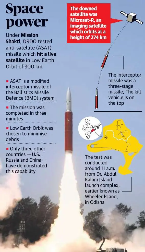
  • Public Awareness and Education: through national portals, media engagement, civil society involvement, etc.
  • Training and Capacity Building: NCAP identifies lack of capacity on air quality issues due to limited manpower and infrastructure in the CPCB and SPCBs, lack of formal training for various associated stakeholders etc. as one of the major hurdle in an effective implementation of air pollution management plans.
  • Setting up Air Information Centre: which will be responsible for creating a dashboard, data analysis, interpretation, dissemination. This may be set up with the assistance of the IITs, IIMs.
  • Operationalize the NPL-India Certification Scheme (NPL-ICS) for certification of monitoring instrument. It will help to cater to the country’s needs with respect to the online monitoring of air pollution. The proposed certification scheme will have three major components i.e. NPL-India Certification body (NICB), certification committee, and testing and calibration facility.
  • Air-Quality Forecasting System (AQFS): as a state-of-the-art modelling system, it will forecast the following day’s air quality. The satellite data available through ISRO to be integrated for monitoring and forecasting under the NCAP.
  • Network of Technical Institutions- Knowledge Partners: Dedicated air pollution units will be supported in the universities, organizations, and institutions and a network of highly qualified and experienced academicians, academic administrators, and technical institutions will be created.
  • Technology Assessment Cell (TAC): It will evaluate significant technologies with reference to prevention, control, and abatement of pollution. Technology induction/ transfer would be facilitated, where necessary, with time bound goals for indigenization and local manufacturing.o The TAC will be created involving the IITs, IIMs, the major universities, industries, and using the existing mechanisms and programme of the Department of Science & Technology, India Innovation Hub, etc.