Great Indian bustard (Ardeotis Nigriceps) – Population Fall | UPSC IAS

Great Indian bustard (Ardeotis Nigriceps) - Population Fall UPSC IAS

Great Indian bustard (Ardeotis Nigriceps) - Population Fall  UPSC IAS

Great Indian bustard (Ardeotis Nigriceps) – Population Fall | UPSC – IAS

A recent study suggests that, Great Indian Bustard population has been falling continuously, from around 1,260 in 1969 to less than 200 in 2018.

About Great Indian bustard (Ardeotis Nigriceps)

  • It’s among the heaviest bird with a horizontal body and long bare legs giving it an ostrich like appearance.
  • Habitat: Arid and semi-arid grasslands, open country with thorn scrub, tall grass interspersed with cultivation. It avoids irrigated areas.
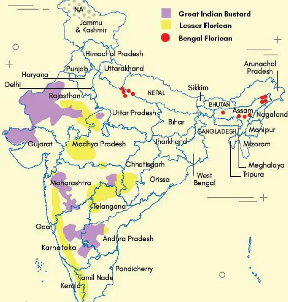
  • Currently, it is found in only six states in the country –
    • Madhya Pradesh,
    • Gujarat,
    • Maharashtra,
    • Andhra Pradesh,
    • Rajasthan and
    • Karnataka.
  • It is endemic to Indian Sub-continent, found in central India, western India and eastern Pakistan.
  • Protection: Listed in Schedule I of the Wildlife (Protection) Act, 1972 and Critically Endangered on the IUCN Red List
  • It is also listed in Appendix I of CITES and covered under CMS or Bonn Convention.
  • Bustard Species Found In India: Great Indian Bustard, the Lesser Florican and the Bengal Florican; Houbara also belong to Bustard family but it’s a migratory species.
  • Importance to Ecosystem: GIB is an indicator species for grassland habitats and its gradual disappearance from such environments shows their deterioration.
  • Once the species is lost, there will be no other species to replace it, and that will destabilise the ecosystem of the grassland and affect critical bio-diversities, as well as blackbucks and wolves, who share their habitat with the GIB.
  • Threat: Hunting, poaching, habitat erosion, ‘greening’ projects that transform arid grasslands to wooded areas, change of land use from grassland to farmland, collisions with high tension electric wires, fast moving vehicles and free-ranging dogs in villages
Great Indian bustard (Ardeotis Nigriceps) - Population Fall | UPSC IAS PIB PCS UPPCS UPPSC the Hindu

Conservation Steps:

Great Indian Bustard, popularly known as ‘Godawan’, is Rajasthan’s state bird. The state government has started “Project Godawan” for its conservation at Desert National Park (DNP) in Jaisalmer. It’s one of the Species for The Recovery Programme under the Integrated Development of Wildlife Habitats of the Ministry of Environment and Forests.

Integrated Development of Wildlife Habitats | UPSC – IAS

It is a Centrally Sponsored Scheme where GoI provides financial and technical assistance to the State/UT Governments for activities aimed at wildlife conservation. The scheme has three components viz- Support to Protected Areas (National Parks, Wildlife Sanctuaries, Conservation Reserves and Community Reserves), Protection of Wildlife Outside Protected Area and Recovery programmes for saving critically endangered species and habitats.

Great Indian bustard (Ardeotis Nigriceps) Recovery Programme

  • It recommends linking local livelihoods with bustard conservation
  • A profitable and equitable mechanism to share revenues generated from ecotourism with local communities should be developed
  • For effective conservation, the guidelines direct state governments to identify the core breeding areas for bustards and keep them inviolate from human disturbances
  • The guidelines suggest restriction on infrastructure development and land use diversion for roads, high tension electric poles, intensive agriculture, wind power generators and construction
  • Only low intensity, traditional pastoral activities should be allowed, that too, not during the breeding season, say the guidelines

Convention on the Conservation of Migratory Species of Wild Animals (CMS) or Bonn convention

  • It is the only convention under UNEP which provides a global platform for the conservation and sustainable use of migratory animals and their habitats ( and their migration routes). India is a member of the convention.
  • Migratory species threatened with extinction are listed on Appendix I of the Convention.

Blue Economy its Significance and Challenges | UPSC – IAS

Blue Economy upsc

Blue Economy upsc

Blue Economy and its Components | UPSC – IAS

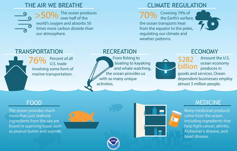
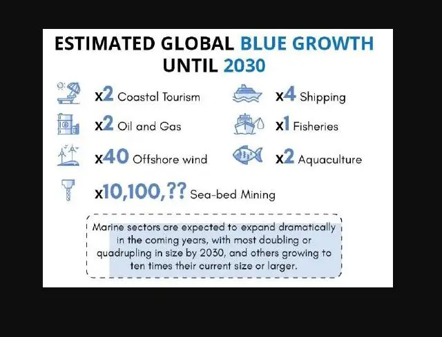
As per the World Bank, Blue Economy is the sustainable use of ocean resources for economic growth, improved livelihoods, and jobs while preserving the health of ocean ecosystem. It covers several sectors linked directly or indirectly to the oceans such as –

  • Fishing, minerals, shipping and port infrastructure,
  • Marine biotechnology,
  • Marine renewable energy,
  • Marine tourism,
  • Ocean governance and education.

Blue Economy its Significance and Challenges | UPSC - IAS

Significance of Blue economy | UPSC – IAS

Economic Benefits:

  • Oceans provide 30 percent of oil and gas resources.
  • 90% of goods trade takes place through Oceans Sea of Line Communication.
  • Ocean contributes $2.5 trillion to world economy with around 60 million people are employed in fisheries and aquaculture.
  • Seabed Mining of polymetallic nodules and polymetallic sulphides to extract nickel, cobalt, manganese and rare earth metals.

Environmental Benefits:

  • Mangroves and other vegetated ocean habitats sequester 25 percent of the extra CO2 from fossil fuels, i.e., Blue Carbon.
  • Protection of coastal communities from disasters like floods and storms.
  • A Sustainable Blue Economy can help to achieve commitments under UN’s Sustainable Development Goals 2030, Paris climate agreement 2015 and the UN Ocean Conference 2017.

Challenges to Blue Economy | UPSC – IAS

  • Unsustainable development near marine areas: Physical alterations and destruction of marine and coastal habitats & landscapes largely due to coastal development, deforestation, & mining.
  • FAO estimates that approximately 57 percent of fish stocks are fully exploited and another 30 percent are over-exploited, depleted, or recovering.
  • Marine pollution: It is in the form of excess nutrients from untreated sewerage, agricultural
    runoff, and marine debris such as plastics. Deep sea mining can cause long term irreversible ecological damage to marine ecosystem.
  • Impacts of climate change: Threats of both slow-onset events like sea-level rise and more intense and frequent weather events like cyclones. Long-term climate change impacts on ocean systems like changes in sea temperature, acidity, and major oceanic currents.
  • Geopolitical issues: Geopolitical tussle between in various regions like South China Sea, Indian Ocean Region etc. and undermining International Laws like UNCLOS limits the countries from achieving the full potential of Blue Economy.
  • Unfair trade practices: Many times fishing agreements allow access to an EEZ of country to foreign operators. These operators restrict transfer of specific fishing knowledge to national stakeholders leading to low appropriation of fisheries export revenues by national operators. So the potential for national exploitation of those resources is reduced in the long run.
  • Other non-conventional threats: Defense and security related threats like piracy and terrorism combined with natural disasters (Small Island Developing States are particularly vulnerable).

Blue economy and India  | UPSC – IAS

India is trying to achieve the potential of Blue Economy by promoting the spirit of ‘SAGAR-Security and Growth for All in the Region’ in Indian Ocean Region. Some initiatives by India are:  (important for UPSC)

Sagarmala Project: Sagarmala initiative focus on three pillars of development

  • Supporting and enabling Port-led Development through appropriate policy and institutional interventions.
    • Port Infrastructure Enhancement, including modernization and setting up of new ports.
    • Efficient Evacuation to and from hinterland by developing new lines/linkages for transport (including roads, rail, inland waterways and coastal routes).
  • Coastal Economic Zones: 14 CEZs are being developed under Sagarmala initiative covering all the Maritime States.
    • CEZs are spatial economic regions comprising of a group of coastal districts or districts with a strong linkage to the ports in that region.
    • CEZ will help to tap synergies of planned economic corridors.
  • Resource exploration: India in recent times has shifted its focus towards Indian Ocean resource exploration. E.g. India has explored 75000 sq km of Indian Ocean Seabed and is developing technologies (like remotely operated vehicles) for mining the resources
  • International relations and security: India is cooperating with Indian Ocean littoral countries and projecting itself as ‘net security provider’ to ensure a safe, secure and stable Indian Ocean Region (IOR). India is also cooperating with extra regional powers like US, Japan in IOR. E.g. Asia-Africa growth corridor, QUAD etc.

Sustainable Blue Economy Conference

  • It’s the first global conference on the sustainable blue economy.
  •  It was convened by Kenya and co-hosted Canada and Japan.

Archipelagic & Territorial waters, and Contiguous zone | UPSC

INS kohassa - India’s fourth Air Station UPSC IAS Gk today

Different Areas under UNCLOS III :Internal waters

Covers all water and waterways on the landward side of the baseline. The coastal state is free to set laws, regulate use, and use any resource. Foreign vessels have no right of passage within internal waters.

Territorial waters :

  • Out to 12 nautical miles from the baseline, the coastal state is free to set laws, regulate use, and use any resource.
  • Vessels were given the right of innocent passage through any territorial waters, with strategic straits allowing the passage of military craft as transit passage, in that naval vessels are allowed to maintain postures that would be illegal in territorial waters.
  • “Innocent passage” is defined by the convention as passing through waters in an expeditious and continuous manner, which is not “prejudicial to the peace, good order or the securityof the coastal state.
  • Fishing, polluting, weapons practice, and spying are not “innocent“, and submarines and other underwater vehicles are required to navigate on the surface and to show their flag. Nations can also temporarily suspend innocent passage in specific areas of their territorial seas, if doing so is essential for the protection of its security.

Archipelagic waters :

  • The convention defines how the state can draw its territorial borders.
  • A baseline is drawn between the outermost points of the outermost islands, subject to these points being sufficiently close to one another.
  • All waters inside this baseline are designated Archipelagic Waters.
  • The state has full sovereignty over these waters (like internal waters), but foreign vessels have right of innocent passage through archipelagic waters (like territorial waters).

Contiguous zone :

Contiguous zone is 24 nautical miles from the territorial sea baseline in which a state could continue to enforce laws in four specific areas: pollution, taxation, customs, and immigration.

What are the factors affecting the salinity of the sea water ? | UPSC – IAS

salinity describe the general distribution of salinity in the oceans UPSC IAS factors affecting salinity of ocean water

salinity describe the general distribution of salinity in the oceans UPSC IAS factors affecting salinity of ocean water

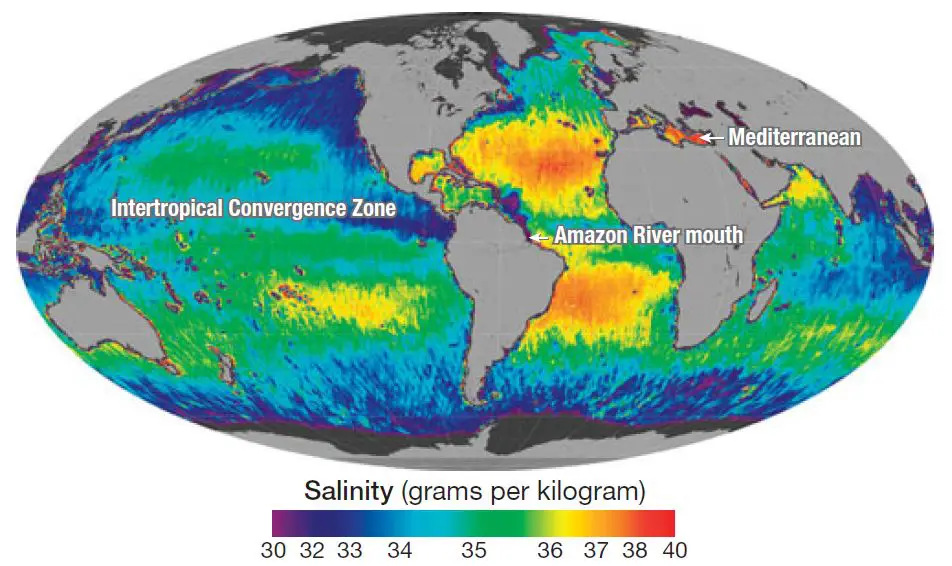
[ Image explanation – Lowest salinity (violet and blue areas) is found in areas of freshwater runoff, such as the mouths of rivers, and where rainfall is high (as in the ITCZ); highest salinity (red and yellow) is found where evaporation rates are highest.]

Factors affecting the salinity of the sea or ocean water | UPSC – IAS

The salinity of ocean water is a measure of the concentration of dissolved salts, which are mostly – sodium chloride but also include salts containing magnesium, sulfur, calcium, and potassium. The average salinity of seawater is about 35 parts per thousand, or 3.5 percent of total mass.

  • The geographic distribution of surface salinity varies. At any given location on the ocean surface, the salinity depends on how much evaporation is taking place and how much freshwater (primarily from rainfall and stream discharge) is being added.

What are the two factors that affect the salinity of ocean water ?

  • The salinity of Ocean water in the surface layer of oceans depend mainly on evaporation and precipitation.
  • Evaporation of ocean water and formation of sea ice both increase the salinity of the ocean.
  • However these “salinity raising” factors are continually counter-balanced by the processes that decrease salinity such as the continuous input of fresh water from, precipitation of – rain, rivers & snow.

Note – Where the evaporation rate is high, so is salinity; where the inflow of freshwater is high, salinity is low

  • Surface salinity is greatly influenced in coastal regions by the freshwater flow from rivers, and in polar regions by the processes of freezing and thawing of ice.
  • Wind, also influences salinity of an area by transferring water to other areas.
  • The ocean currents contribute to the salinity variations. Salinity, temperature and density of water are interrelated. Hence, any change in the temperature or density influences the salinity of an area.

Highest and Lowest Salinity of Ocean Water | UPSC – IAS

Typically the lowest salinities are found where rainfall is heavy and near the mouths of major rivers. Salinity is highest in partly landlocked seas in dry, hot regions because here the evaporation rate is high and stream discharge is minimal.

As a general pattern, salinity is low in equatorial regions because of heavy rainfall, cloudiness, and humidity, all of which inhibit evaporation, and also because of considerable river discharge. Salinity rises to a general maximum in the subtropics, where precipitation is low and evaporation extensive, and decreases to a general minimum in the polar regions, where evaporation is minimal and there is considerable inflow of freshwater from rivers and ice caps. Where the evaporation rate is high, so is salinity; where the inflow of freshwater is high, salinity is low

Note – Atlantic ocean is saltiest out of all oceans

  • Surface waters in the Atlantic have the highest salinity, higher than 37 parts per thousand in some areas. This is because, on average, there is more evaporation than combined rainfall and river runoff into the Atlantic Ocean, maintaining higher salinity than in the other basins.
  • Effects of ocean salinity – Although ocean salinity does vary from place to place, the variability of dissolved salt is very small: from about 32 parts per thousand to about 37 parts per thousand. Nonetheless, this small variation can have a massive influence on ocean circulation.

Salinity of Ocean water Affects Ocean Water Density | UPSC – IAS

  • Seawater density varies with temperature, degree of salinity, and depth. High temperature produces low density, and high salinity produces high density. Deep water has high density because of low temperature and because of the pressure of the overlying water.
  • Surface layers of seawater tend to contract and sink in cold regions, whereas in warmer areas deeper waters tend to rise to the surface.
  • Surface currents also affect this situation, particularly by producing an upwelling of colder, denser water in some localities. As we will see later in this chapter, differences in density are partially responsible for a vast, slow circulation of deep ocean water.

Salinity of freshwater | UPSC – IAS

  • Salinity of freshwater is nearly equal to zero. The salinity of water in the ocean averages about 35 parts per thousand (ppt). The mixture of seawater and fresh water in estuaries is called brackish water and its salinity can range from 0.5 to 35 ppt.

Vertical distribution of salinity in oceans | UPSC – IAS

  • Very cold and very salty water forms in polar regions every winter. This cold and salty water is denser, so it sinks toward the seafloor.

Pacific ocean salinity

Salinity also varies latitudinally, reaching a maximum of 37 parts per thousand in the southeastern area. The water near the equator, which can have a salinity as low as 34 parts per thousand, is less salty than that found in the mid-latitudes because of abundant equatorial precipitation throughout the year.

  • Indian ocean salinity – The surface salinity in Indian ocean ranges from 32 to 37 parts per 1000.

Enclosed Seas in the world (example)

  • Enclosed Sea — black sea ,dead sea
  • Partially enclosed Sea – Mediterranean sea, red sea

Theory of Isostasy | Geography Optional | UPSC – IAS

Postulations of Airy theory of Isostasy

Theory of Isostasy | Geography Optional | UPSC – IAS

Introduction to Theory of Isostasy

The term “Isostasy” is derived from “Isostasios”, a word of Greek language meaning the state of being in balance or equal standing or in equipoise. The theory of isostasy explains, the tendency of the earth’s crust to attain equilibrium and the distribution of the material in the earth’s crust which conforms to the observed gravity values.

The Theory of Isostasy UPSC IAS

  • Theory of Isostasy, is a fundamental concept in geology, is based on the opposing influence of two main forces – Buoyancy and Gravity
  • It is the state of gravitational equilibrium between earth’s crust and mantle, Such that – The crust floats at an elevation that depends on its thickness and density.
  • It is the idea that the lighter crust must be floating on the denser underlying mantle.

History and Explanation (Theory of Isostasy)

  • Theory of Isostasy was developed from gravity surveys in the mountains of India, in 1850. The term was first proposed by Clarence Dutton, an American geologist in 1889.
  • This doctrine states that wherever equilibrium exists in the earth’s surface, equal mass must underlie equal surface areas; in other words a great continental mass must be formed of lighter material than that supposed to constitute the ocean-floor.
  • Thus, there exists a gravitational balance between crustal segments of different thickness. According to Dutton, the elevated masses are characterized by rocks of low density and the depressed basins by rocks of higher density.
  • In order to compensate for its greater height these lighter continental material must extend downward to some distance under the continent and below the ocean-floor level in order that unit areas beneath the oceans and continents may remain in stable equilibrium.
  • Accordingly, a level of uniform pressure is thought to exist where the pressure due to elevated masses and depressed areas would be equal. This is known as the ‘Isopiestic-Level‘.

Understanding the Concept of Theory of Isostasy

  • It is invoked to explain how different topographic heights can exists on the Earth’s surface. Isostatic equilibrium is an ideal state where the crust and mantle would settle into in absence of disturbing forces. These are the examples of processes that perturb isostasy :-
    • The waxing and waning of ice sheets,
    • Erosion, sedimentation, and
    • Extrusive volcanism
  • The physical properties of the lithosphere (the rocky shell that forms Earth’s exterior) are affected by the way the mantle and crust respond to these perturbations.
  • Therefore, understanding the dynamics of isostasy helps us figure out more complex phenomena such as:-
    • Mountain building,
    • Sedimentary basin formation,
    • The break-up of continents and
    • The formation of new ocean basins

Postulations of Airy (Theory of Isostasy – UPSC)

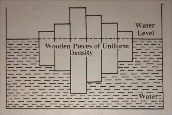
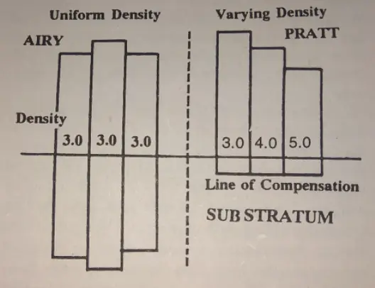
  • According to him the crust of relatively lighter material is floating in the substra­tum of denser material. In other words, ‘sial’ is floating in ‘sima’.
  • He considered the density of different columns (plains, plateaus, mountains, etc.) to be the same. Hence, he proposed the idea of ‘Uniform density with varying thickness’.

Postulations of Airy theory of Isostasy

Postulations of Pratt  (Theory of Isostasy – UPSC)

  • Pratt considered land blocks of various heights to be different in terms of their density.
  • The taller landmass has lesser density and smaller height features to be denser. If there is a higher column, density will be lesser and if there is a shorter column, density will be higher
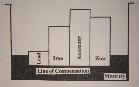
  • He accepted that all blocks of different height get compensated at a certain depth into the substratum. Thus, he denounced the root concept of Airy and accepted the ‘concept of a level of compensation’.

Postulations of Pratt - Theory of Isostasy


Difference between pratt and airy Isostasy

      Views of Airy        Views of Pratt
•Uniform density of crustal  material. •Varying density of  crustal  material.
•Varying depth up to which root penetrates. crustal material reaches. •Uniform depth up to which crustal material reaches.
•Deeper root below the    mountain  and smaller   beneath plain. •No root formation, but a  level of Compensation.

Both theories predict a relative deficiency of mass under high mountains,

  • But –Airy’s theory is now known to be a better explanation of mountains within continental regions, whereas –

Pratt’s theory essentially explains the difference between continents and oceans, since the continent crust is largely of granitic composition which is less dense than the basaltic ocean basin.

UPSC – CSE  Previous Year’s Questions (Mains)

  • UPSC – CSE 2001 : Present a critical analysis of the theory of isostasy.
  • UPSC – CSE 2007 : Define the concept of isostasy and discuss the postulations of Airy and Pratt.
  • UPSC – CSE 2011 : Explain the concept of Isostasy as postulated by Airy and Pratt
  • Difference between pratt and airy isostasy or Examine the difference between airy and pratt in view of isostasy..

Why are the world’s major deserts located on 20 to 30 degrees of latitude?

As you follow the Tropics of Cancer and Capricorn, thirty degrees on either side of the equator, you will see, distributed with suspicious regularity an earthy colored band of drylands surrounding the planet, a sere belt averting greener climes: the deserts of the world. They lie in the so-called Horse Latitudes, where constant high-pressure systems drive away the rain clouds.

Why are deserts often located at 30 degrees from the equator ?

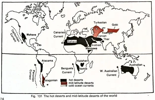
There are four major reasons responsible for why the major hot deserts of the world are located between 20° – 30° N on the west of the continents:-

Offshore trade winds

  • Offshore trade winds in the region and location in rain shadow zone – Trade winds that blow in the region, shed their moisture on the eastern  part and by the time they reach the western margin, they become dry.

Anticyclonic conditions

  •  Areas between 20–30 degree latitudes on western margins of continents are the regions of descending air. It means the air gets compressed and warm as it descends and thus the moisture holding capacity keeps decreasing.

Leeward sides of mountains/Parallel mountain ranges

  • In the case of few deserts, mountains are situated as a barrier which prevents orographic rainfall. For example:- presence of Rockies on the western coast of North -America does not let moisture bearing winds do rainfall in leeward sides. In the case of Thar desert in India, Aravallis are situated parallel to the region. Therefore the moisture holding winds pass away from the region because there is absence of mountain barriers.

Presence of cold ocean currents

  • Presence of cold ocean currents along the western coast of continents – tend to stabilise the air over the coast. This prevents cloud formation and rainfall