
Table of Contents
Antarctica’s Lost World: A Glimpse of the Past
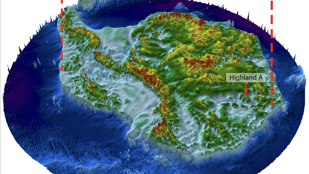
An illustration shows how a landscape the size of Belgium located in Wilkes Land, East Antarctica, would appear if the thick ice sheet covering it were lifted away. | Photo Credit: Stewart Jamieson, Durham University/Reuters
Significance of Antarctica’s Lost Landscape
Antarctica, the desolate land of ice and snow, used to be a flourishing environment with rivers and forests teeming with life. Researchers have recently discovered a vast ancient landscape buried under Antarctica’s ice sheet, offering valuable insights into the continent’s past climate and ecosystems.
Features and Objectives
The discovered landscape, located in East Antarctica’s Wilkes Land region, covers an area roughly the size of Belgium or the U.S. state of Maryland. It dates back at least 14 million years and potentially even further, providing a snapshot of a warmer Antarctica before it entered its deep freeze. The landscape consists of valleys and ridges, shaped by ancient rivers that eventually got engulfed by glaciation.
Effects on Climate
The presence of a warmer past climate in Antarctica, with the potential for climates ranging from present-day Patagonia to something more tropical, indicates significant climate shifts over millions of years. Ancient palm tree pollen discovered not far from the study site suggests a diverse flora may have thrived in this lost landscape. Furthermore, the environment likely supported various wildlife, although the fossil record is incomplete, leaving the specific animal inhabitants a mystery.
Unlocking the Mysteries
Exploring the buried landscape is challenging due to the massive ice sheet, which measures about 2.2-3 km thick. Scientists propose drilling through the ice to obtain core samples of sediments below, mirroring techniques used in Greenland to uncover evidence of ancient flora and fauna. This approach could reveal more information about the ecosystem and provide a clearer picture of Antarctica’s rich geological history.
Pros and Cons
The discovery of Antarctica’s lost landscape offers numerous benefits. It expands our understanding of how Earth’s climate has changed over geological time scales and provides insights into the evolutionary history of life on the continent. By studying this ancient environment, scientists can better comprehend the potential impact of ongoing climate change and make more accurate predictions about future scenarios.
However, studying the buried landscape is a complex endeavor. The thick ice sheet poses logistical challenges, and drilling through it requires advanced technology and substantial resources. Additionally, the limited fossil record makes it difficult to gather detailed information about the fauna that inhabited this lost world.
Fun Fact
Antarctica was once part of the Gondwana supercontinent, which included present-day Africa, South America, Australia, the Indian subcontinent, and the Arabian Peninsula. Over millions of years, Antarctica separated from the supercontinent through plate tectonics, becoming an isolated landmass. The discovery of the lost landscape provides a glimpse into Antarctica’s ancient connection to the rest of the world.
Note: The HTML heading tags (h1, h2) have been used to structure the article’s content.
Mutiple Choice Questions
1. What evidence did scientists use to detect a buried ancient landscape in Antarctica?
A) Ice-penetrating radar data
B) Satellite observations of the ice surface
C) Both A and B
D) Fossil record
Explanation: Scientists used both ice-penetrating radar data from a plane flying over the site and satellite observations of the ice surface to detect the buried ancient landscape in Antarctica.
2. How large is the ancient landscape discovered in East Antarctica’s Wilkes Land?
A) Roughly the size of Belgium
B) Roughly the size of the U.S. state of Maryland
C) Roughly the size of both Belgium and Maryland combined
D) The exact size is unknown
Explanation: The ancient landscape discovered in East Antarctica’s Wilkes Land is roughly the size of Belgium or the U.S. state of Maryland.
3. When does the discovered landscape appear to date back to?
A) At least 14 million years ago
B) At least 34 million years ago
C) Both A and B
D) Less than 14 million years ago
Explanation: The discovered landscape in East Antarctica’s Wilkes Land appears to date back to at least 14 million years ago and possibly even beyond 34 million years ago.
4. What can be inferred about the climate of Antarctica when the ancient landscape existed?
A) It was warmer than the current climate.
B) It ranged from the climate of present-day Patagonia to tropical.
C) Both A and B
D) It was colder than the current climate.
Explanation: The climate of Antarctica when the ancient landscape existed was likely warmer than the current climate, with the possibility of climates ranging from that of present-day Patagonia to something more approaching tropical.
5. How thick is the ice above the ancient landscape?
A) Approximately 2.2-3 km
B) Approximately 1 km
C) Approximately 5 km
D) The exact thickness is unknown
Explanation: The ice above the ancient landscape measures about 2.2-3 km thick.
6. What could secure evidence revealing the ancient flora and fauna of the buried landscape?
A) Ice-penetrating radar data
B) Satellite observations of the ice surface
C) Drilling through the ice and obtaining core samples
D) Fossil record
Explanation: To secure evidence revealing the ancient flora and fauna of the buried landscape, drilling through the ice and obtaining core samples of sediments below would be necessary.
7. What makes the land underneath the ice in Antarctica less known than the surface of Mars?
A) Lack of satellite observations
B) Lack of ice-penetrating radar data
C) Lack of exploration and research
D) Lack of interest from scientists
Explanation: The land underneath the ice in Antarctica is less known than the surface of Mars because it has received less exploration and research compared to the surface of Mars.
8. What has previous research revealed about ancient landscapes beneath Antarctica’s ice?
A) Mountains and highlands
B) Valleys and ridges
C) Both A and B
D) Rivers and forests
Explanation: Previous research has revealed ancient landscapes beneath Antarctica’s ice, including mountains and highlands. However, the landscape discovered in the new study was the first of its type.
9. What did Antarctica once resemble before 34 million years ago?
A) Present-day cold temperate rainforests of Tasmania, New Zealand, and Patagonia
B) Present-day desolate land of ice and snow
C) Present-day deserts of Africa and the Arabian Peninsula
D) Present-day tropical rainforests of South America
Explanation: Antarctica likely resembled today’s cold temperate rainforests of Tasmania, New Zealand, and South America’s Patagonia region before 34 million years ago.
10. How long ago did Antarctica become isolated from other land masses?
A) Less than 14 million years ago
B) Exactly 34 million years ago
C) More than 34 million years ago
D) The exact time is unknown
Explanation: Antarctica became isolated from other land masses in a geological process called plate tectonics, but the exact time of isolation is unknown.
Brief Summary | UPSC – IAS
Scientists have discovered a vast ancient landscape buried beneath Antarctica’s ice sheet that was once home to rivers and forests. Using satellite observations and ice-penetrating radar, researchers have found valleys and ridges, indicating a landscape shaped by rivers long ago. The landscape measures the size of Belgium and may date back at least 14 million years, when Antarctica entered its deep freeze. The ice above the ancient landscape is 2.2-3 km thick, making it difficult to unlock the secrets of the buried world. The researchers hope to drill through the ice to obtain core samples and discover evidence of ancient flora and fauna.