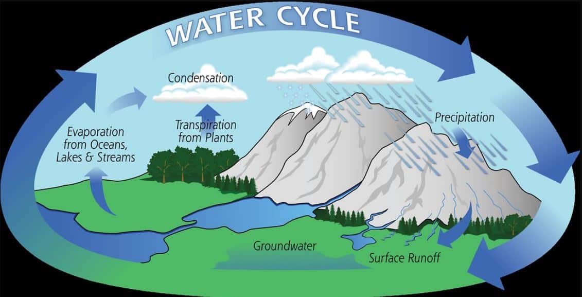
Precipitation is an important step concerned with hydrological cycle. So it is very interesting to know how water moves upward to the sky and how we get the rain. As such precipitation is an interesting topic, and today we are going to discuss this topic under the following captions. They are:-
- Definition of precipitation
- Formation, Size and Rate of Precipitation
- Different classes of precipitation
- Precipitation measurement
- Effects of Climate Change on precipitation
Concept of precipitation | UPSC – IAS
Precipitation in meteorology refers to all forms of liquid or solid water particles that form in the atmosphere and then fall to the earth’s surface. Precipitation is defined as liquid or solid condensation of water vapor falling from clouds or deposited from air onto the ground. It is the primary connection in the water cycle that provides for the delivery of atmospheric water to the Earth.
- It includes rain, sleet, snow, hail and drizzle plus a few less common occurrences such as ice pellets, diamond dust and freezing rain. Frost and dew are not classified as precipitation because they form directly on solid surfaces.
There are two types of precipitation, liquid and solid types.
- Solid precipitation: Precipitation in the form of ice flakes, such as snow, is called solid precipitation, and that in the form of water drops is sometimes called liquid precipitation.
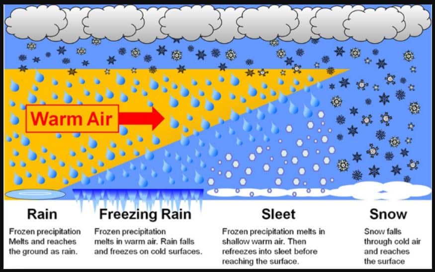
- Liquid precipitation: Liquid forms of precipitation include rain and drizzle. Rain or drizzle that freezes on contact within a subfreezing air mass is called “freezing rain” or “freezing drizzle”. Frozen forms of precipitation include snow, ice needles, ice pellets, hail, and graupel.
So, what is rain?
- Rain is drops of liquid water falling from the sky. In order for the raindrops to become heavy enough to fall, droplets of water in the cloud collide together with other droplets and other particles in the air – like soot and dust – to become larger. Once the drops become too heavy to stay in the cloud, it falls as rain.
Raindrops can be up to 6 mm in diameter, but anything less than 0.5 mm is considered as drizzle. Drizzle consists of very small droplets of water falling from low level stratus clouds. Drizzle droplets are less than 0.5 mm in diameter – larger than the droplets in clouds, but smaller than raindrops.
- Freezing rain is rain droplets which fall in supercooled liquid form, but freeze on contact with the ground or another object to form clear ice – also known as glaze. Supercooling occurs in clouds where droplets remain in a liquid form in temperatures below the normal freezing point. In order for the super-cooled droplets to freeze on contact, the ground temperature is normally close to or below 0 °C. Freezing rain can fall as rain droplets or drizzle.
Solid precipitation: Hail is solid precipitation in the form of balls or pieces of ice known as hailstones. Hail only forms in cumulonimbus clouds – more commonly known as thunder clouds.
- In thunderclouds, drops of water are continuously taken up and down through the cloud. When they go to the top of the cloud, it is very cold and they freeze. As the up draughts in thunderclouds are very big, they can keep these hailstones for a long time, so they get larger and larger by becoming coated with more and more ice. Then, when they get really big, the up draughts in the cloud cannot hold them up anymore and they fall to earth, and by this time they are big balls of ice, and so don’t have time to melt before they reach the ground. Hail can only be formed in this way, unlike snow which can be formed in fronts, and orographically too, just like rain. Hailstones can vary in size from 5 mm to 150 mm in diameter, however most hailstones are smaller than 25 mm.
- Another form of solid precipitation is Ice pellets. Ice pellets are snowflakes which have started to melt, and then re-frozen as they fall through colder air. The result is a grainy snow pellet encased in ice. Ice pellets are generally smaller than hailstones and bounce when they hit the ground.
- Snow is tiny ice crystals stuck together to become snowflakes. If enough ice crystals stick together, they’ll become heavy enough to fall to the ground.
- When coming to sleet, it has no internationally agreed definition but is reported in meteorological observations as “rain and snow mixed”. Sleet, which is sometimes known as ice pellets, is basically snow which has begun the melting process before it reaches the ground.
So, next question is what is diamond dust? | UPSC – IAS
Diamond dust, sometimes just called ice crystals, consists of extremely small ice crystals, usually formed at low levels at temperatures below -30° C. The name diamond dust comes from the sparkling effect created when light reflects on the ice crystals in the air.
Formation, Size and Rate of Precipitation | UPSC – IAS
- The clouds floating overhead contain water vapor and cloud droplets, which are small drops of condensed water. These droplets are very too small to fall as precipitation, but they are large enough to form visible clouds. Water is continually evaporating and condensing in the sky. If you look closely at a cloud you can see some parts disappearing (evaporating) while other parts are growing (condensation).
- Most of the condensed water in clouds does not fall as precipitation because their fall speed is not large enough to overcome updrafts which support the clouds. For precipitation to happen, first tiny water droplets must condense on even tinier dust, salt, or smoke particles, which act as a nucleus. Water droplets may grow as a result of additional condensation of water vapor when the particles collide. If enough collisions occur to produce a droplet with a fall velocity which exceeds the cloud updraft speed, then it will fall out of the cloud as precipitation. This is not a trivial task since millions of cloud droplets are required to produce a single raindrop. A more efficient mechanism (known as the Bergeron-Findeisen process) for producing a precipitation-sized drop is through a process which leads to the rapid growth of ice crystals at the expense of the water vapor present in a cloud. These crystals may fall as snow, or melt and fall as rain.
- Rain is the liquid form of precipitation on Earth. It is part of the hydrologic cycle that begins when water evaporates and forms clouds in the atmosphere. The water that forms these clouds is frozen and vaporized. Once enough water has evaporated, it is then released in the form of droplets of rain back to the surface of the Earth.
- A stationary raindrop initially experiences acceleration due to gravity as would any falling body. As gravity increases the speed of the raindrop in its descent, drag retards the downward acceleration of the raindrop. Usually, air resistance that comes in contact with the water molecules as they fall causes the drag. The combination of these two forces causes a raindrop to reach a terminal velocity when the drag force is approximately equal to the weight of the raindrop. At this point, a raindrop experiences no further acceleration and therefore falls at a constant velocity.
- The magnitude of the terminal velocity of an object is also affected by its orientation. A common misconception is the shape of the raindrop. It is often depicted as pointy and lopsided.
- Precipitation rates vary geographically and over time. Precipitation does not fall in the same amounts throughout the world, in a country, or even in a city.
- The Global Precipitation Measurement Core Observatory (GPM) surveys Earth’s weather from 65 degrees north to 65 degrees south latitude. GPM works along with a constellation of other satellites to provide worldwide coverage.
- On the ground, precipitation can be measured by an array of rain gauges scattered around the world. From its 253-mile-high (407 kilometers) orbit, the GPM satellite passes over almost the entire world. GPM circles the globe every 93 minutes, completing 16 orbits per day. GPM is one of a constellation of weather satellites.
- The satellite carries a microwave imager. Its scanning antenna rotates 32 times per minute, while a downward pointing detector reads microwaves reflected from the atmosphere below. As it orbits, GPM scans the Earth’s atmosphere with its Dual-Frequency Precipitation Radar.
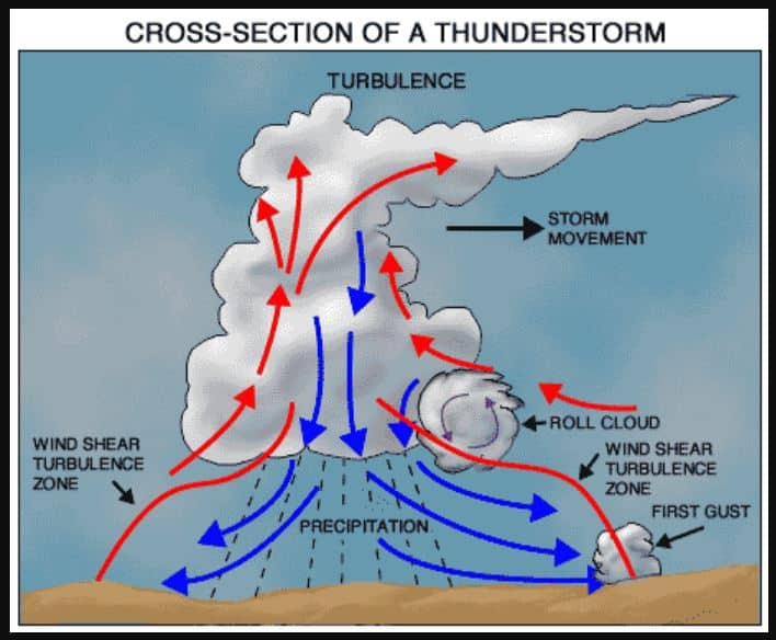
Different kinds of precipitation or Rainfall | UPSC – IAS
There are three types of rainfall explain with suitable diagram:-
- Convectional rainfall
- Orographic rainfall
- Cyclonic rainfall.
Orographic Precipitation or Rainfall | UPSC – IAS
Orographic precipitation results when warm moist air moving across the ocean is forced to rise by large mountains. As the air rises, it cools; this is because a higher elevation results in cooler temperatures.
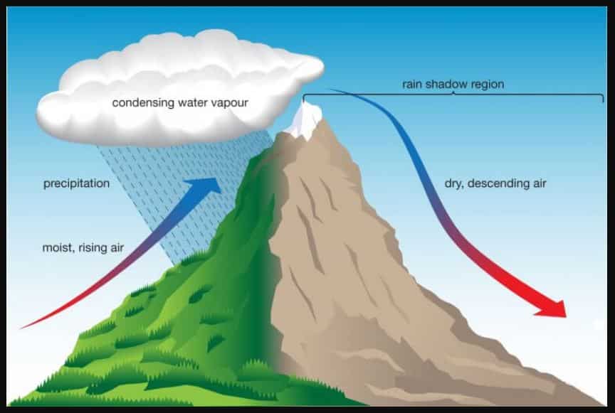
Cold air cannot hold as much moisture as warm air. As air cools, the water vapor in the air condenses and water droplets form. Cloud forms and precipitation (rain or snow) occurs on the windward side of the mountain. Then the air is dry and rises over the top of mountain. As the air moves back down the mountain, it collects moisture from the ground via evaporation. This side of the mountain is called the leeward side. It receives very little precipitation.
- In orographic rainfall, the leeward side of the mountain gets less rainfall.
- Orographic precipitation occurs due to air masses being lifted to higher altitudes by a mountain.
Convectional Precipitation or Rainfall | UPSC – IAS
- Convective precipitation is also known as thermodynamic precipitation. Convectional precipitation results from the heating of the earth’s surface. The warm ground heats the air over it. As the air warms, the air molecules begin to move further apart. With increased distance between molecules, the molecules are less densely packed.
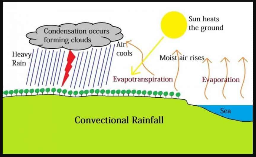
- Thus, the air becomes “lighter” and rises rapidly into the atmosphere. As the air rises, it cools. Water vapor in the air condenses into clouds and precipitation. This type of precipitation is common in the Prairies and Ontario.
Characteristics of convectional rainfall:-
- Heavy rainfall with lightning and thunder takes place which does not last long.
- This type of rainfall generally takes place in the equatorial regions and internal parts of the continents, predominantly in the northern hemisphere.
- Such rain is usually in the summer or the hotter part of the day.
- This rainfall is usually associated with hail and graupel,
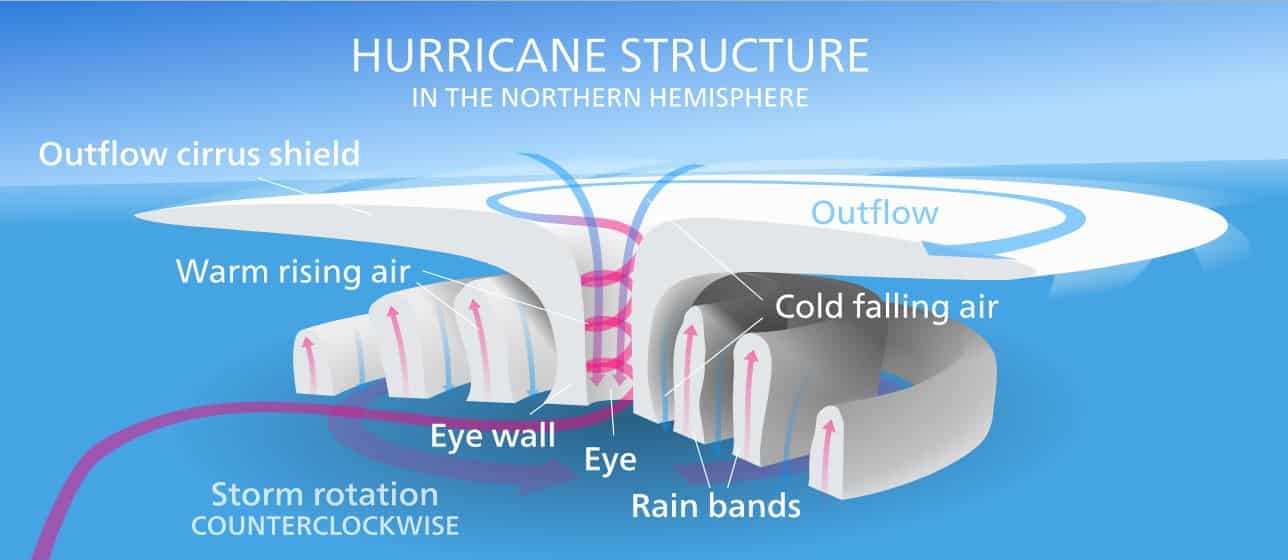
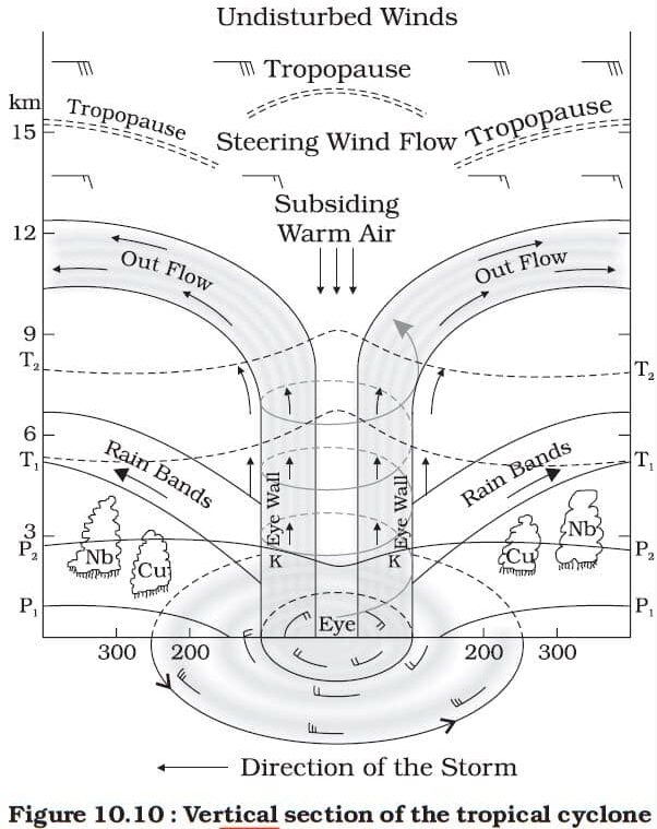
Cyclonic or Frontal precipitation or Rainfall | UPSC – IAS
- Cyclonic or Frontal precipitation results when the leading edge of a warm, moist air mass meets a cool and dry air mass. The molecules in the cold air are more tightly packed together, and thus, the cold air is heavier than the warm air. The warmer air mass is forced up over the cool air. As it rises, the warm air cools, the water vapor in the air condenses, clouds and precipitation results. This kind of precipitation is common in Atlantic Canada.
- This type of system is called Frontal Precipitation because the moisture tends to occur along the front of the air mass.
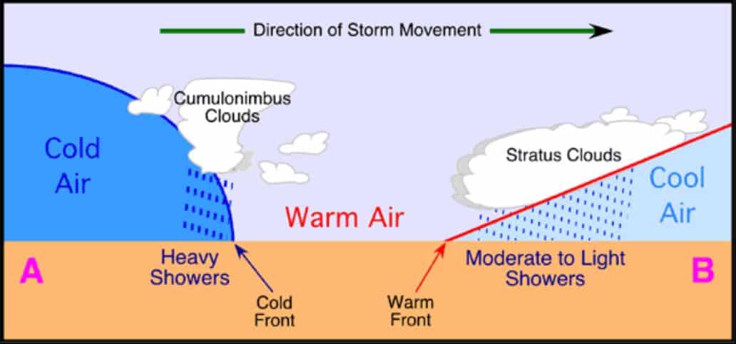
- A cyclonic storm is a large, low pressure system that forms when a warm air mass and a cold air mass collide. This collision often occurs under the polar-front jet stream which spreads cold, dry arctic air near warm, moist tropical air. The rotation of the earth causes the air to circulate in a counterclockwise direction around an area of low pressure.
Other Types of Rainfall | UPSC – IAS
Dynamic precipitation or stratiform precipitation | UPSC – IAS
- Dynamic precipitation is also known as stratiform precipitation. Dynamic precipitation results from a forced lifting of air. These forcing mechanisms include processes that cause low level convergence and upper level divergence.
- As unsaturated air rises the relative humidity of the air will increase. Once the air saturates, continued lifting will produce clouds and eventually precipitation. Dynamic precipitation tends to have a less intense rain rate than convective precipitation and also tends to last longer.
Monsoonal Rainfall Characteristics | UPSC – IAS
This type of precipitation is characterized by seasonal reversal of winds that carry oceanic moisture (especially the south-west monsoon) with them and cause extensive rainfall in the south and southeast Asia.
- The duration of the monsoon is between 100 to 120 days from early June to mid-September.
- A monsoon arises due to a difference in temperatures between a land mass and the adjacent ocean.
- Around the time of its arrival, the normal rainfall increases suddenly and continues for several days. This is known as the ‘burst’ of the monsoon.
- A wind from the southwest or south that brings heavy rainfall to southern Asia in the summer.
Effects of Climate Change on precipitation | UPSC – IAS
- As temperatures rise and the air becomes warmer, more moisture evaporates from land and water into the atmosphere. More moisture in the air generally means we can expect more rain and snow (called precipitation) and more heavy downpours. But this extra precipitation is not spread evenly around the globe, and some places might actually get less precipitation than they used to get. That is because climate change causes shifts in air and ocean currents, which can change weather patterns.
- On average, the world is already getting more precipitation now than it did 100 years ago: nearly 2 percent more worldwide. The effects vary by region.
- In future precipitation is expected to increase in higher latitudes and decrease in areas closer to the Equator.
- This is the matter of concern, because too little or too much water can be a problem. In many places, people depend on rain and snowmelt to fill lakes and streams and provide a source of water for drinking, watering crops, and other uses. However, heavy rain can cause flooding.
Effects on agriculture due to Precipitation:
- The crops that we grow for food need specific conditions to thrive, including the right temperature and enough water. A changing climate could have both positive and negative effects on crops. Global climate change will also affect agriculture and food supply in many other ways.
- Climate change could make it too hot to grow certain crops, and droughts caused by climate change could reduce the amount of water available for irrigation. Climate change is also likely to cause stronger storms and more floods, which can damage crops. Higher temperatures and changing rainfall patterns could help some kinds of weeds and pests to spread to new areas.
Effects on water supply due to Precipitation:
- Climate change is affecting where, when, and how much water is available for people to use. Many parts of the world already have very little water, and climate change could make this problem worse. Rising temperatures, changing precipitation patterns, and increasing droughts will affect the amount of water in lakes, rivers, and streams, as well as the amount of water that seeps into the ground to replenish ground water.
Effects on forests due to Precipitation:
- Forests provide homes for many kinds of plants and animals. They also protect water quality, offer opportunities for recreation, and provide people with wood. Forests are sensitive to many effects of climate change, including shifting weather patterns, drought, wildfires, and the spread of pests like the mountain pine beetle. Unlike some animals, trees can’t just get up and move when the temperature gets too hot or other conditions change!
- As the Earth gets warmer and droughts increase, wildfires are expected to occur more often and be more destructive. Wildfires do occur naturally, but the extremely dry conditions resulting from droughts allow fires to start more easily, spread faster, and burn longer. Fires don’t just change the landscape; they also threaten people’s homes and lives.
- Directly or indirectly global climate change affecting precipitation pattern and there by threatening human beings.
Conclusion | UPSC – IAS
- All of the precipitation that falls originated as water vapor that was evaporated from the surface of the Earth. It is always raining somewhere on the Earth, just as evaporation is always occurring over most of the Earth’s surface. So, a cloudy day with no precipitation indicates that there is either
- Not enough water vapor available to the cloud for precipitation to form, or
- That the rising motion creating the cloud is not strong enough — or there may be both the reasons.