We all know the sky can be full of water. But most of the time we can’t witness the water. The drops of water are too small to see. Clouds are visible accumulations of water droplets or solid ice crystals that float in the Earth’s troposphere moving with the wind. From space, clouds are visible as a white blanket surrounding the planet. So in this session we are going to discuss the origin, types and also importance of clouds.
Origin of clouds | UPSC – IAS
As defined by the World Meteorological Organization (WMO), it’s primarily “a hydrometeor consisting of a visible aggregate of minute particles of liquid water or ice, or both, suspended in the free air and usually not touching the Earth’s surface.”Thus, clouds are the visible sign of ongoing atmospheric processes and as such they are a useful diagnostic tool.
Clouds are made of tiny drops of water or ice crystals that settle on dust particles in the atmosphere. The droplets are so small – i.e., a diameter of about a hundredth of a millimeter – in which each cubic meter of air contain 100 million droplets.
Formation of clouds | UPSC – IAS
Clouds form when the invisible water vapor in the air condenses into visible water droplets or ice crystals. There is water around us all the time in the form of tiny gas particles, also known as water vapor. There are some tiny particles floating around in the air – such as salt and dust – these are called aerosols.
The water vapor and the aerosols are constantly bumping into each other. When the air is cooled, some of the water vapor sticks to the aerosols when they collide – this is like condensation. Eventually, bigger water droplets form around the aerosol particles, and these water droplets start sticking together with other droplets, forming clouds.
The warmer the air is, the more water vapor it can hold. Clouds are usually produced through condensation – as the air rises, it will cool and reduced temperature of the air, decreases its ability to hold water vapor so that condensation occurs. The height at which dew point is reached and clouds are formed that point is called as condensation level.
Required elements for cloud formation
Clouds consist of many tiny droplets resulting from the condensation of water vapor (gaseous state) into liquid water or ice (solid state). They form when the air is cooled to its dew point. This is considered its condensation or saturation point.
The first requirement for cloud formation is moisture. This moisture is constantly recycled through the earth-atmosphere system by means of the hydrologic cycle. Moisture in this cycle exists normally in the 3 states of water: solid, liquid, and vapor.
The primary way to cool the atmosphere is through upward vertical motion or lifting of air. Thus the second requirement for cloud formation is a source of lift, through the following processes:
Fronts associated with low pressure systems Orographic or mountain barriers
Convection
Convergence (forced coming together of airflow)
While vertical motion is the primary method of cooling that leads to cloud formation, there are two other atmospheric cooling processes. These processes are advection and radiation, and they can lead to cooling of the lower layers of the atmosphere.
Advection refers to the horizontal movement of air or moisture across the earth’s surface. For example, if mild moist air moves (advects) over a snow pack or other cold surface (land or water), the air may be cooled to its saturation point from below. This may lead to fog formation.
Radiational cooling can also cool the lower layers of the atmosphere on clear, calm and dry nights. As the earth’s surface cools, it will cool the air in contact with it. This air may be cooled to its saturation point resulting in the formation of late night or early morning fog or ground fog. This type of fog occurs frequently in river valleys.
Thus, moisture and lift are required for cloud formation. This lift must cool the atmosphere sufficiently so it approaches its dew point or saturation point.
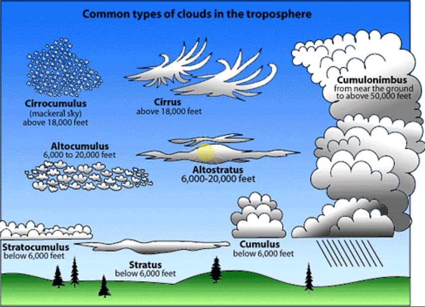
Types of Clouds | UPSC – IAS
Clouds are an important part of Earth’s weather. There are many kinds of clouds. The meteorologist classifies clouds mainly by their appearance.
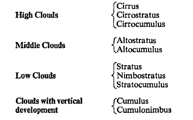
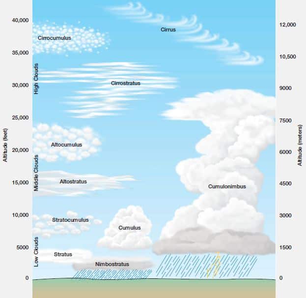
After World War II, the World Meteorological Organization published a new International Cloud Atlas (1956) in two volumes. It contains 224 plates, describing 10 main cloud genera (families) subdivided into 14 species based on cloud shape and structure. Nine general varieties, based on transparency and geometric arrangement are also described. The genera, listed according to their height, are as follows:
High clouds: These clouds are high up in the sky, mean heights from 5 to 13 km, or 3 to 8 miles. The important high cloud types are,
Cirrus
Cirrocumulus
Cirrostratus
Middle clouds: Middle clouds are found between low and high clouds, mean heights 2 to 7 km, or 1 to 4 miles. The following are some important middle clouds,
Altocumulus
Altostratus
Low clouds: Low clouds form closer to Earth’s surface. Low clouds can even touch the ground, mean heights 0 to 2 km, or 0 to 1.2 miles.. These clouds are called as fog. They are,
Nimbostratus
Stratocumulus
Stratus
Cumulus
Cumulonimbus
Another way the clouds are named is by their shape. Cirrus clouds are high clouds. They look like feathers. Cumulus clouds are middle clouds. These clouds look like giant cotton balls in the sky. Stratus clouds are low clouds. They cover the sky like bed sheets.
Heights given are approximate averages for temperate latitudes. Clouds of each genus are generally lower in the Polar Regions and higher in the tropics.
Four principal classes are recognized when clouds are classified according to the kind of air motions that produce them:
Layer clouds formed by the widespread regular ascent of air,
Layer clouds formed by widespread irregular stirring or turbulence,
Cumuliform clouds formed by penetrative convection, and
Orographic clouds formed by the ascent of air over hills and mountains.
So what are the causes for cloud formation?
There are five factors which can lead to air rising, cooling and clouds formation
Surface heating – This happens when the ground is heated by the sun which heats the air in contact with it causing it to rise. The rising columns are often called thermals. Surface heating tends to produce cumulus clouds.
Topography forcing – The topography – or shape and features of the area – can cause clouds to be formed. When air is forced to rise over a barrier of mountains or hills it cools as it rises. Layered clouds are often produced by this way.
Frontal – Clouds are formed when a mass of warm air rises up over a mass of cold, dense air over large areas along fronts. A ‘front’ is the boundary between warm, moist air and cooler, drier air.
Convergence – Streams of air flowing from different directions are forced to rise where they flow together, or converge. This can cause cumulus cloud and showery conditions.
Turbulence – A sudden change in wind speed with height creating turbulent dynamics in the air.
The range of ways in which clouds can be formed and the variable nature of the atmosphere results in an enormous variety of shapes, sizes and textures of clouds.
Atmospheric processes creating lift and clouds | UPSC – IAS
Since cold air (dense) sinks and warm air (less dense) rises, clouds that form in an unstable environment (warm below and cold aloft) tend to be lumpy or globular in appearance. These clouds will resemble bubbles in a pot of boiling water.
These are the cumuliform or convective clouds that we are all familiar with and are due to the localized nature of the sudden updrafts and downdrafts of convection.
On the other hand, a stable environment (cold surface and warm aloft) is characterized by a more gradual lifting process resulting in extensive areas of layered or stratiform type clouds. These clouds last longer than those involved in convective processes.
Clouds due to lift by fronts
For over three-quarters of the 20th century, the low pressure/cyclone conceptual model developed by the Norwegian School of meteorologists has dominated weather analysis techniques. With the advances in satellite and radar technology, this concept continues to evolve, but the conceptual model still forms the foundation for understanding frontal lift and cloud formation.
In the case of a warm front, both the warm advancing air and the cold retreating air are moving in the same direction. As warm air glides up and over cold surface air (warm front), the clouds tend to be layered.
In contrast, cold fronts cause more abrupt lifting with more intense localized vertical motion as the cold and warm air masses collide. This generally results in cumuliform clouds with showery conditions as the cold air undercuts and forces the warm air up.
Frontal lift Clouds are generally of the stratiform layered type (stable) when associated with warm fronts. Cold fronts are generally associated with cumuliform clouds (unstable). Thunderstorms are most likely with cold fronts but can accompany warm fronts.
Orographic lift clouds
Air flow perpendicular to a range of hills or mountains is forced to rise up and over the mountains (i.e. the orographic barrier). As the air rises on the windward side of the mountain range (or hills), it cools (expansion) and may eventually reach its saturation point with clouds forming. The reverse is true as the air descends down the leeward side of the mountains. This subsiding air is warmed through compression.
Subsiding, warming air can hold more moisture before reaching saturation. As a result, clouds tend to break up to the lee of mountains.
This process frequently happens during a winter snowstorm, with heavy snow along the windward side and lesser amounts to the lee of the mountains. It is referred to as the umbrella or shadowing effect of mountains.
Lift due to convection
We are all familiar with the white cotton ball (cumulus) type clouds on a warm summer afternoon. This is the process of convection.
The earth’s atmosphere is transparent to incoming solar radiation. Once this radiation hits the ground, it will convert to heat energy. As the ground warms, the air in contact with the ground is also warmed through conduction.
As the air is warmed, it becomes less dense, thus it rises (convection). However, as air rises it cools, with clouds ultimately forming over the updraft. The spacing of these up and down drafts results in the observed distribution of cumulus clouds. On the edges of the clouds, cool air sinks to replace the warm air rising, thereby completing the convection cell.
Lift due to Convection results in clouds and may occur in combination with other forms of lift (frontal or orographic) with showers or thunderstorms ultimately developing.
Convergence and lift
Another source of lift, which is really a combination of the above processes, is convergence. When air is forced to converge or come together, it can only go upward (can’t go into the ground). An example would be the air flowing inward toward the center of low pressure which is forced to rise.
Colors of clouds | UPSC – IAS
Before going to cloud color, we must understand why the sky is blue? The rays from the sun have all of the colors in the visible color spectrum in them, so the rays appear to be white. This “white” sunlight passes through the Earth’s atmosphere, and the tiny airborne molecules, such as nitrogen particles, scatter the light from the blue part of the color spectrum. The molecules scatter the blue light until it is evenly distributed. The other colors in the spectrum reach the Earth’s surface with no interference, so their color isn’t distributed throughout the sky. Therefore, the sky appears to be blue.
Clouds are white because the water droplets are bigger than the particles that scatter the blue light in the sky. The clouds scatter and reflect all the visible colors of light that strike them. Since the visible colors of the sun appear to be white, the clouds that reflect that light must be white too. So clouds are white because they reflect the white light from the sun.
In some cases, if the cloud is super thick or filled with a lot of water molecules; sunlight cannot pass through the cloud. Therefore, clouds can appear very dark because of the lack of sunlight shining through.
The white colors of clouds come from the condensed water vapor having a high reflective quality. When all wavelengths of light are reflected back we can see white color. The grey color comes from seeing clouds from beneath. White clouds are white if we notice, on sunny days. This is because we can see the sunlight directly hitting them and see that light almost completely reflected back. On cloudy days most sunlight is blocked by the translucent and refractive quality of cloud cover. This makes clouds appear darker in color as part of the light has been uniformly absorbed.
The color of a cloud also depends on the color of the light that illuminates it. When sunlight passes through thick layer of atmosphere and dust particles at sunset, blue color is scattered by Rayleigh scattering and only red-to-orange color remains. The clouds reflect these unscattered red/orange rays and appear in that color. The effect is much like shining a red spotlight on a white sheet.
Since the Earth is spherical, the clouds at different heights turn red at different time when the sun crosses the horizon. Just before the sunset, the color of low clouds (e.g. stratus) will turn red first. Shortly after the sunset, the high clouds (e.g. cirrus) would be gradually stained in deep red and become apparent under the darken background. A viewer on the ground can distinguish the clouds at different heights according to the relative timing of their color change during sunset.
Clouds at night are visible only when there is a source of light. Thin clouds will generally appear white under the white moonlight. For the bottom of dense low clouds, the main light source is the light from the ground originated from street lamps and other light sources in cities. Such light shines on the cloud aloft and is scattered by the base of a low cloud, making the low cloud appears yellowish orange or white when observed in urban area. The phenomena will be more obvious if the cloud is lower or denser.
Finally, clouds have color. Some are white, some are grey, and in special circumstances such as major storms can have weird colors like green or red. This goes back to refraction. Most color that we can see is visible, because our eyes perceive how objects absorb or reflect certain wavelengths of light
Importance of clouds | UPSC – IAS
Clouds are essential to the earth-atmosphere system. Clouds complete the following functions:
Clouds help to regulate Earth’s energy balance by reflecting and scattering solar radiation and by absorbing Earth’s infrared energy.
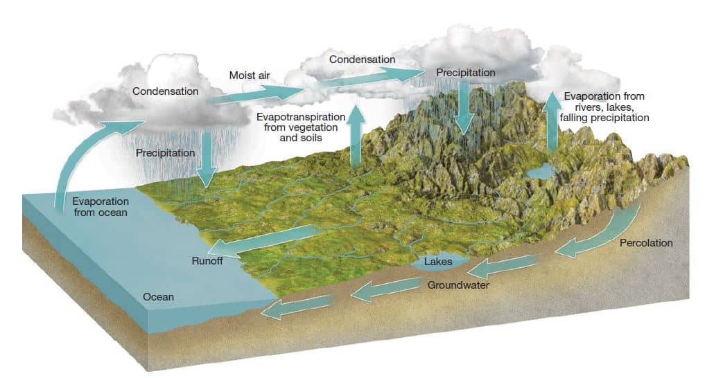
They are required for precipitation to occur and, hence are an essential part of the hydrologic cycle.
Clouds indicate what type of atmospheric processes are occurring (e.g., cumulus clouds indicate surface heating and atmospheric turbulence).
Clouds help to redistribute the extra heat from the equator toward the poles.
Clouds are important for many reasons. Rain and snow are two of those reasons. At night, clouds reflect heat and keep the ground warmer. During the day, clouds make shade that can keep us cooler.
Clouds are an important part of our atmosphere and they have a critical role in controlling the amount of the sun’s energy that reaches the earth’s surface. Clouds can have a cooling effect on the atmosphere, which counteract increases in temperature caused by climate change. Understanding exactly how clouds impact on our climate and ensuring that we can accurately model the current role and extent of clouds is critical to determine how any changes in climate will affect clouds and how clouds will affect climate in the future.
In order to predict the climate several decades into the future, we need to understand many aspects of the climate system, one being the role of clouds in determining the climate’s sensitivity to change. Clouds affect the climate but changes in the climate, in turn, affect the clouds. This relationship creates a complicated system of climate feedbacks, in which clouds modulate Earth’s radiation and water balances.
Clouds are an important part of the water cycle. The water cycle is the movement of water from the Earth into the sky and then back down to Earth again.
The sun heats water on the surface of the Earth, and causes it to evaporate. Evaporation is the process when water moves from liquid to vapor form. Water vapor is made up of tiny water droplets in the air. Water can also move into the air through transpiration.
The greenhouse effect is not only produced by the greenhouse gases, clouds absorb long wavelength (infrared) radiation from the surface of the Earth and radiate some of it back down. In addition to this absorption and re-radiation of infrared radiation from the Earth’s surface they may simply reflect it back to the surface.
Clouds also have a major role in reflecting some of the Sun’s short wavelength (visible light) radiation back into space. Thus clouds share a role with the greenhouse gases and also share a role with the ice and snow fields of the high latitudes.
Conclusion | UPSC – IAS
A cloud is a large collection of very tiny droplets of water or ice crystals. The droplets are so small and light that they can float in the air. All air contains water, but near the ground it is usually in the form of an invisible gas called water vapor.
When warm air rises, it expands and cools. Cool air can’t hold as much water vapor as warm air, so some of the vapor condenses into tiny pieces of dust that are floating in the air and forms a tiny droplet around each dust particle. When billions of these droplets come together they become a visible cloud.
Clouds are important in weather forecasting and also play an important role in hydrological cycle.