Classification of Air masses and Fronts | Geography Optional | UPSC – IAS
Air Masses
Although the troposphere is a continuous body of mixed gases that surrounds the planet, it is by no means a uniform blanket of air. Instead, it is composed of many large parcels of air that are distinct from one another. Such large parcels are referred to as air masses.
Characteristics Air Masses
To be recognized as a distinct air mass, a parcel of air must meet three requirements:
It must be large. A typical air mass is more than 1600 kilometers (1000 miles) across and several kilometers deep (from Earth’s surface to the top of the air mass).
It must have uniform properties in the horizontal dimension. This means that at any given altitude in the air mass, its physical characteristics:- primarily temperature, humidity, and stability; are relatively homogeneous.
It must travel as a unit. It must be distinct from the surrounding air, and when it moves it must retain its original characteristics and not be torn apart by differences in airflow.
Origin of Air Masses
An air mass develops its characteristics when it stagnates or remains over a uniform land or sea surface long enough to acquire the temperature/humidity/stability characteristics of the surface below.
This stagnation needs to last for only a few days if the underlying surface has prominent temperature and moisture characteristics. Stable air is more likely to remain stagnant for a few days than unstable air, so regions with anticyclonic (high pressure) conditions commonly form air masses.
Source Regions of Air Masses
The formation of air masses is usually associated with what are called source regions: regions of Earth’s surface that are particularly well suited to generate air masses. Such regions must be extensive, physically uniform, and associated with air that is stationary or anticyclonic.
Ideal source regions are – ocean surfaces and extensive flat land areas that have a uniform covering of snow, forest, or desert.
Air masses rarely form over the irregular terrain of mountain ranges.
Image portrays the principal recognized source regions for air masses that affect North America. Warm air masses can form in any season over the waters of the southern North Atlantic, the Gulf of Mexico/Caribbean Sea, and the southern North Pacific, and in summer, they can form over the deserts of the southwestern United States and northwestern Mexico. Cold air masses develop over the northern portions of the Atlantic and Pacific Oceans and over the snow-covered lands of north-central Canada.
It may well be that the concept of source regions is of more theoretical value than actual value. A broader view, one subscribed to by many atmospheric scientists, holds that air masses can originate almost anywhere in the low or high latitudes but rarely in the midlatitudes due to the prevailing westerlies where persistent wind would prevent air mass formation.
Classification of Air Masses
Air masses are classified on the basis of source region. The latitude of the source region correlates directly with the temperature of the air mass, and the nature of the surface strongly influences the humidity content of the air mass.Thus,
A low-latitude air mass is warm or hot
A high-latitude one is cool or cold.
If the air mass develops over a continental surface, it is likely to be dry; if it originates overan ocean, it is usually moist. A one- or two-letter code is generally used to identify air masses. Although some authorities recognize other categories, the basic classification is sixfold are as follows:-
Movement and Modification of Air Masses
Some air masses remain in their source region for long periods, even indefinitely. In such cases, the weather associated with the air mass persists with little variation. Our interest, however, is in masses that leave their source region and move into other regions, particularly into the midlatitudes. When an air mass departs from its source region, its structure begins to change. This change is due in part to thermal modification (warming or cooling from below), in part to dynamic modification (uplift, subsidence, convergence, turbulence), and perhaps also in part to addition or subtraction of moisture.
Once it leaves its source area, an air mass modifies the weather of the regions into which it moves: it takes source-region characteristics into other regions.
A midwinter outburst of continental polar (cP) air from northern Canada sweeps down across the central part of North America. With a source-region temperature of −46°C (−50°F) around Great Slave Lake, the air mass has warmed to −34°C (−30°F) by the time it reaches Winnipeg, Manitoba, and it continues to warm as it moves southward. Throughout its southward course, the air mass becomes warmer, but it also brings some of the coldest weather that each of these places will receive all winter. Thus, the air mass is modified, but it also modifies the weather in all regions it passes through. Temperature, of course, is only one of the characteristics modified by a moving air mass. There are also modifications in humidity and stability.
North American Air Masses
The North American continent is a prominent area of air mass interaction. The lack of mountains trending east to west permits polar air to sweep southward and tropical air to flow northward unhindered by terrain, particularly over the eastern two-thirds of the continent. In the western part of the continent, though, air masses moving off the Pacific are impeded by the prominent north– south trending mountain ranges.
Continental polar (cP) – Air masses develop in central and northern Canada, and Arctic (A) air masses originate farther north and so are colder and drier than cP air masses – both are dominant features in winter with their cold, dry, stable nature. Maritime polar (mP) air from the Pacific in winter can bring cloudiness and heavy precipitation to the mountainous west coastal regions. In summer, cool Pacific mP air produces fog and low stratus clouds along the coast. North Atlantic mP air masses are also cool, moist, and unstable, but except for occasional incursions into the mid-Atlantic coastal region, Atlantic mPair does not affect North America because the prevailing circulation of the atmosphere is westerly.
Maritime tropical (mT)air from the Atlantic/Caribbean/ Gulf of Mexico is warm, moist, and unstable. It strongly influences weather and climate east of the Rockies in the United States, southern Canada, and much of Mexico, serving as the principal precipitation source in this broad region. It is more prevalent in summer than in winter, bringing periods of uncomfortable humid heat. Pacific mT air originates over water in areas of anticyclonic subsidence, and so it tends to be cooler, drier, and more stable than Atlantic mT air; it is felt only in the southwestern United States and northwestern Mexico, where it may produce coastal fog and moderate orographic rainfall where forced to ascend mountain slopes. It is also the source of some summer rains in the southwestern interior.
Continental tropical (cT) air is relatively unimportant in North America because its source region is not extensive. In summer, hot, very dry, unstable cT air surges into the southern Great Plains area on occasion, bringing heat waves and dry conditions.
Equatorial (E) air affects North America only in association with hurricanes. It is similar to mT air except that E air provides an even more copious source of rain than does mT air because of high humidity and instability.
FRONTS
When unlike air masses meet, they do not mix readily; instead, a boundary zone called a front develops between them. A front is not a simple two-dimensional boundary. A typical front is a narrow three-dimensional transition zone several kilometers or even tens of kilometers wide. Within this zone, the properties of the air change rapidly.
The frontal concept was developed by Norwegian meteorologists during World War I, and the term front was coined because these scientists considered the clash between unlike air masses to be analogous to a confrontation between opposing armies along a battle front. As the more “aggressive” air mass advances at the expense of the other, some mixing of the two occurs within the frontal zone, but for the most part the air masses retain their separate identities as one is displaced by the other.
Types of Fronts
(Cold, Warm, Stationary, and Occluded)
The most conspicuous difference between air masses is usually temperature. A cold frontforms where an advancing cold air mass meets and displaces warmer air (see image), whereas a warm front forms where an advancing warm air mass meets colder air (see image).
In both cases, there is warm air on one side of the front and cool air on the other, with a fairly abrupt temperature gradient between.
Air masses may also have different densities, humidity levels, wind patterns, and stability, and so these factors can have a steep gradient through the front as well. In some cases, a front may remain stationary for a few hours or even a few days.
More commonly, however, a front is in more or less constant motion. Usually one air mass is displacing the other; thus, the front advances in the direction dictated by the movement of the more active air mass. Regardless of which air mass is advancing, it is always the warmer air that rises over the cooler.
The warmer, lighter air is inevitably forced aloft, and the cooler, denser air mass functions as a wedge over which the lifting occurs. As you can see in both the images fronts “lean” or slope upward from the surface, and it is along this slope that the warmer air rises and cools adiabatically to form clouds and often precipitation.
Indeed, fronts lean so much that they are much closer to horizontal features than vertical ones. The slope of a typical front averages about 1:150, meaning that 150 kilometers away from the surface position of the front, the height of the front is only 1 kilometer above the ground.
Because of this very low angle of slope (less than 1°), the steepness shown in most diagrams of fronts is greatly exaggerated. Notice that the “leading edge” of a cold front precedes its higher altitude “trailing edge,” whereas a warm front leans “forward” so that the higher altitude part of the front is ahead of its lower altitude “trailing edge.”
Cold Fronts
Image Explanation: A cold front forms when a cold air mass is actively underriding a warm air mass. As a cold front advances, the warm air ahead of it is forced upward. This displacement often creates cloudiness and relatively heavy precipitation along and immediately behind the groundlevel position of the front. (In this diagram, the vertical scale has been exaggerated.)
Because of friction with the ground, the advance of the lower portion of a cold air mass is slowed relative to the upper portion. As a result, a cold front tends to become steeper as it moves forward and usually develops a protruding “nose” a few hundred meters above the ground.
The average cold front is twice as steep as the average warm front. Moreover, cold fronts normally move faster than warm fronts because the dense, cold air mass easily displaces the lighter, warm air.
This combination of steeper slope and faster advance leads to rapid lifting and adiabatic cooling of the warm air ahead of the cold front. The rapid lifting often makes the warm air very unstable, and the result is blustery and violent weather along the cold front.
Vertically developed clouds, such as cumulonimbusclouds, are common, with considerable turbulence and showery precipitation.
Both clouds and precipitation tend to be concentrated along and immediately behind the ground-level position of the front. Precipitation is usually of higher intensity but shorter duration than that associated with a warm front.
On a weather map, the ground-level position of a cold front is shown either by a blue line or a solid line studded at intervals with solid triangles that extend in the direction toward which the front is moving.
Warm Fronts
Image Explanation – A warm front forms when a warm air mass is actively overriding a cold air mass. As warm air rises above cooler air, widespread cloudiness and precipitation develop along and in advance of the ground-level position of the front. Higher and less dense clouds are often dozens or hundreds of kilometers ahead of the ground-level position of the front. (In this diagram, the vertical scale has been exaggerated.)
The slope of a typical warm front is more gentle than that of a cold front, averaging about 1:200. As the warm air pushes against and rises over the retreating cold air, it cools adiabatically, usually resulting in clouds and precipitation.
Because the frontal uplift is very gradual, clouds form slowly and turbulence is limited. High-flying cirrus clouds may signal the approaching front many hours before it arrives. As the front comes closer, the clouds become lower, thicker, and more extensive, typically developing into altocumulus or altostratus. Precipitation usually occurs broadly;
It is likely to be protracted and gentle, without much convective activity. If the rising air is inherently unstable, however, precipitation can be showery and even violent. Most precipitation falls ahead of the ground-level position of the moving front.
The ground-level position of a warm front is portrayed on a weather map either by a red line or by a solid line along which solid semicircles are located at regular intervals, with the semicircles extending in the direction toward which the front is moving
Stationary Fronts
When neither air mass displaces the other or if a cold front or warm front “stalls” their common boundary is called a stationary front. It is difficult to generalize about the weather along such a front, but often gently rising warm air produces limited precipitation similar to that along a warm front.
As Image shows, stationary fronts are portrayed on a weather map by a combination of warm and cold front symbols,alternating on opposite sides of the line—cold air is opposite the triangles, and warm air opposite the half circles.
Occluded Fronts
A fourth type of front, called an occluded front, is formed when a cold front overtakes a warm front. Occluded fronts are shown on a weather map by a combination of warm and cold front symbols, alternating on the same side of the line.
Air Masses, Fronts, and Major Atmospheric Disturbances
We will now turn our attention to the major kinds of atmospheric disturbances that occur within the general circulation. Most of these disturbances involve unsettled and sometimes violent atmospheric conditions and are referred to as storms.
Some, however, produce calm, clear, quiet weather that is quite the opposite of stormy. Some of these disturbances involve air mass contrasts or fronts, and many are associated with migrating pressure cells. The following are common characteristics of atmospheric disturbances in general:-
They are smaller than the components of the general circulation, although they are extremely variable in size.
They are migratory.
They have a relatively brief duration, persisting for only a few minutes, a few hours, or a few days.
They produce characteristic and relatively predictable weather conditions.
Midlatitude Disturbances: The midlatitudes are the principal “battleground” of tropospheric phenomena: where polar and tropical air masses meet, where most fronts occur, and where weather is most dynamic and changeable from season to season and from day to day. Many kinds of atmospheric disturbances are associated with the midlatitudes, but two of these – midlatitude cyclones and mid latitude anticyclones – are much more important than the others because of their size and prevalence.
Tropical Disturbances: The low latitudes are characterized by monotony – the same weather day after day, week after week, month after month. Almost the only breaks are provided by transient atmospheric disturbances, of which by far the most significant are tropical cyclones (locally known as hurricanes when they intensify), but also less dramatic disturbances known as easterly waves.
Localized Severe Weather: Other localized atmospheric disturbances occur in many parts of the world. Short-lived but sometimes severe atmospheric disturbances such as thunderstorms and tornadoes often develop in conjunction with other kinds of storms.
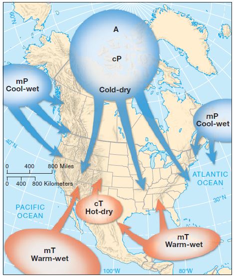
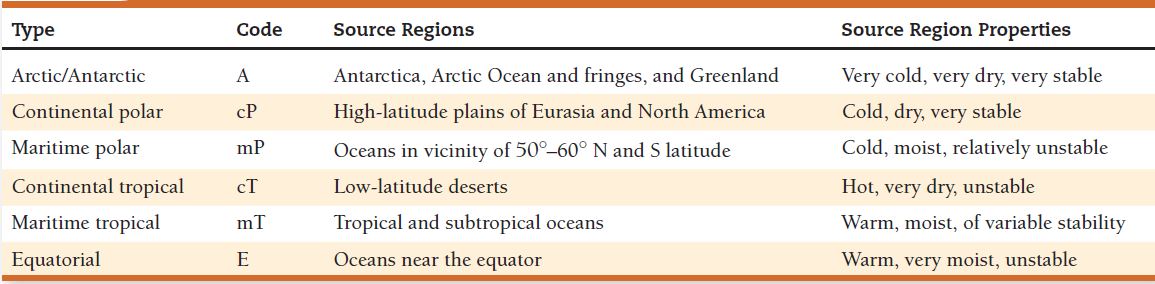
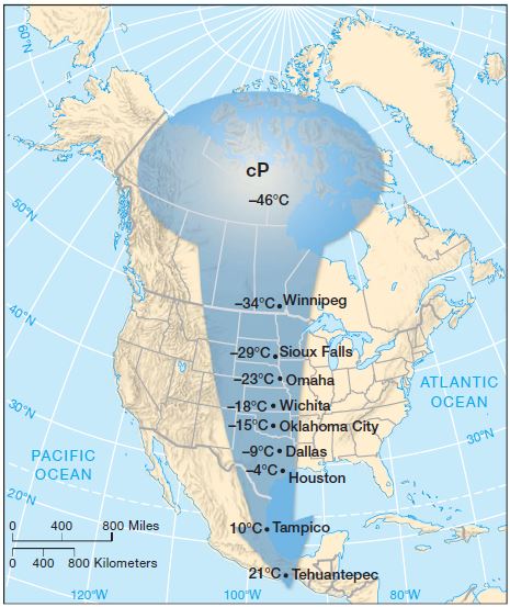
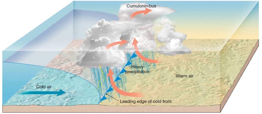 Image Explanation: A cold front forms when a cold air mass is actively underriding a warm air mass. As a cold front advances, the warm air ahead of it is forced upward. This displacement often creates cloudiness and relatively heavy precipitation along and immediately behind the groundlevel position of the front. (In this diagram, the vertical scale has been exaggerated.)
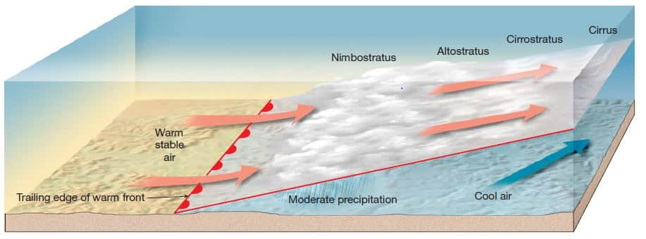 Image Explanation – A warm front forms when a warm air mass is actively overriding a cold air mass. As warm air rises above cooler air, widespread cloudiness and precipitation develop along and in advance of the ground-level position of the front. Higher and less dense clouds are often dozens or hundreds of kilometers ahead of the ground-level position of the front. (In this diagram, the vertical scale has been exaggerated.)


 | UPSC - IAS")


